University of Minnesota
http://www.umn.edu/
612-625-5000
http://www.umn.edu/
612-625-5000
Minnesota Biodiversity Atlas
Bell Museum
Dataset: MIN-Plants
Taxa: Ruscaceae
Search Criteria: excluding cultivated/captive occurrences
Bell Museum plants | |
 MIN:Plants |  Maianthemum canadense Desfontaines 696504[1296988]Smith, Welby 6911978-05-29 United States, Minnesota, Wright, T122N R26W SW1/4 of NW1/4 sect. 35, 45.333902 -93.929411 |
MIN:Plants | Maianthemum canadense Desfontaines 701025[]Dorio, J. 2151977-06-10 United States, Minnesota, Morrison, Ripley Esker, ca. 3 mi. NE of Camp Ripley junction.;Ripley Esker Scientific Natural Area;042N;31W;19, 46.116667 -94.308333 |
MIN:Plants | Maianthemum canadense Desfontaines 723693[]Smith, Welby 23091980-06-01 United States, Minnesota, Wright, Wright Co.; near the SW shore of Schmidt Lake, about 5 mi. E of Buffalo. NW1/4 of SE1/4 of sec.25, T120N R25W;M Schmidt Crawford Woods Scientific Natural Area;120N;25W;25, 45.171303 -93.773325 |
MIN:Plants | Maianthemum canadense Desfontaines 724258[]Smith, Welby 22791980-05-30 United States, Minnesota, Isanti, Ca. 2.5 mi. N of Cambridge, on the W side of hwy. 65.;;036N;23W;16, 45.60954 -93.208771 |
MIN:Plants | Maianthemum canadense Desfontaines 727275[]Smith, Welby 22281980-05-27 United States, Minnesota, Winona, Winona Co. T107N R9W SW1/4 Sec.16. In the valley of Bear Creek, ca. 1 mi. E of Altura.;Dorer Memorial Hardwood State Forest;107N;09W;16, 44.06641 -91.909908 |
MIN:Plants | Maianthemum canadense Desfontaines 728135[]Eikum, B. 1351979-07-17 United States, Minnesota, Dakota, Hastings;Hastings Scientific Natural Area;115N;17W;, 44.73907 -92.86266 |
MIN:Plants | Maianthemum canadense Desfontaines 734859[]Cross-Cella, J. 351980-06-05 United States, Minnesota, Becker, Green Water Lake Natural Area: 5 mi. W of Ponsford.;Greenwater Lake Scientific Natural Area / White Earth Indian Reservation;141N;38W;34, 46.982671 -95.485016 |
MIN:Plants | Maianthemum canadense Desfontaines 741503[]Converse, C. 8651982-05-25 United States, Minnesota, Pope, Moe Woods.;Moe Woods, The Nature Conservancy;123N;36W;34, 45.41981 -95.183337 |
MIN:Plants | Maianthemum canadense Desfontaines 745852[]Smith, Welby 41221981-06-06 United States, Minnesota, Wright, Wright Co.; at the NE end of a small unnamed lake in Hanover; NW1/4 of SE1/4 of sec.35, T120N R24W;;120N;24W;35, 45.156744 -93.673683 |
MIN:Plants | Maianthemum canadense Desfontaines 750192[]Almendinger, J. 29061980-09-24 United States, Minnesota, Hubbard, 1/4 mi. S of Co. Rd. 44.;;144N;34W;27, 47.261724 -94.972799 |
MIN:Plants | Maianthemum canadense Desfontaines 758769[]Smith, Welby 63101982-06-13 United States, Minnesota, Wright, Wright Co.; on the S side of Lake Caroline, about 2 mi. N-NE of South Haven. NE1/4 of SW1/4 of sec.3, T121N R28W;;121N;28W;3, 45.31686 -94.193944 |
MIN:Plants | Maianthemum canadense Desfontaines 782637[]Tenney, M. 1621982-06-02 United States, Minnesota, Winona, Whitewater State Park, Winona Co, T107N R10W Sec.19 SW1/4 NE1/4 SE1/4;Whitewater State Park;107N;10W;19, 44.056381 -92.069193 |
MIN:Plants | Maianthemum canadense Desfontaines 817557[]Taylor, B. T9481891-07-00 United States, Minnesota, Pope, Glenwood.;;N;;, 45.648982 -95.401248 |
MIN:Plants | Maianthemum canadense Desfontaines 832204[]Moyle, J.; et al. 36951941-06-29 United States, Minnesota, Fillmore, Fillmore Co. Near Wycoff;Dorer Memorial Hardwood State Forest / Wykoff Balsam Fir Scientific Natural Area;103N;12W;, 43.718601 -92.256548 |
MIN:Plants | Maianthemum canadense Desfontaines 836750[]Smith, Welby 140281988-05-14 United States, Minnesota, Benton, Benton Co.; Wisneski State Wildlife Management Area, about 5 mi due E of Rice; SE1/4 SE1/4 sec.30, T38N R30W;Wisneski Wildlife Area;038N;30W;30, 45.753334 -94.1166687 |
MIN:Plants | Maianthemum canadense Desfontaines 841089[]Smith, Welby 134961987-07-13 United States, Minnesota, Scott, Murphy-Hanrahan County Park Reserve. Scott County...Murphy-Hanrahan Regional Park, on the S side of Hanrahan Lake, about 2 mi W of Burnsville. SW1/4 NW1/4 sec. 34, T115N R21W. 115N 21W 34, 44.7277778 -93.3363889 |
MIN:Plants | Maianthemum canadense Desfontaines 890077[]Kassube, J. s.n.1878-05-00 United States, Minnesota, Hennepin, Minneapolis.;;N;;, 44.979965 -93.263836 |
MIN:Plants | Maianthemum canadense Desfontaines 89020[]Manning, Sara s.n.1883-06-09 United States, Minnesota, Wabasha, Lake City.;;N;;, 44.449412 -92.266844 |
MIN:Plants | Maianthemum canadense Desfontaines 89056[]Burglehaus, F. s.n.1891-05-29 United States, Minnesota, Hennepin, [no further data];;;;, 45 -93.47 |
MIN:Plants | Maianthemum canadense Desfontaines 89057[]Rosendahl, C. 21501909-06-22 United States, Minnesota, Snelling Reservation [old regional park spanning junction of Minnesota and Mississippi rivers];;028N;23W;, 44.90516 -93.16646 |
MIN:Plants | Maianthemum canadense Desfontaines 89058[]Ballard, C. B681891-06-00 United States, Minnesota, Carver, Chaska.;;N;;, 44.789407 -93.602179 |
MIN:Plants | Maianthemum canadense Desfontaines 89059[]Tilden, Josephine 21893-06-00 United States, Minnesota, Cass, Gull Lake.;;N;;, 46.446379 -94.35099 |
MIN:Plants | Maianthemum canadense Desfontaines 89060[]Butters, F.; et al. R27671914-06-12 United States, Minnesota, Morrison, N of Randall.;;130N;30W;06, 46.091077 -94.50362 |
MIN:Plants | Maianthemum canadense Desfontaines 89061[]Sheldon, Edmund S2181891-06-00 United States, Minnesota, Blue Earth, Lake Washington.;;N;;, 44.23865 -93.867678 |
MIN:Plants | Maianthemum canadense Desfontaines 89062[]MacMillan, C.; et al. 147SK1900-08-00 United States, Minnesota, Polk, Maple Lake;;148N;43W;, 47.659239 -96.15975 |
MIN:Plants | Maianthemum canadense Desfontaines 89063[]Moore, W. s.n.1907-06-04 United States, Minnesota, Ramsey, Groveland Park [St. Paul neighborhood between Highland and Summit aves.];;028N;23W;, 44.93059 -93.185623 |
MIN:Plants | Maianthemum canadense Desfontaines 89065[]Goldsmith, G. G1461912-00-00 United States, Minnesota, Rice, Northfield.;;;;, 44.45833 -93.16139 |
MIN:Plants | Maianthemum canadense Desfontaines 89066[]Ainslie, G. s.n.1902-05-30 United States, Minnesota, Olmsted, Oronoco.;;108N;14W;, 44.158626 -92.527868 |
MIN:Plants | Maianthemum canadense Desfontaines 89067[]Aiton, G. s.n.1891-05-00 United States, Minnesota, Hennepin, Minneapolis.;;N;;, 44.979965 -93.263836 |
MIN:Plants | Maianthemum canadense Desfontaines 89068[]Rosendahl, C. 4161902-06-08 United States, Minnesota, Houston, Spring Grove.;;101N;07W;, 43.543165 -91.672028 |
MIN:Plants | Maianthemum canadense Desfontaines 89069[]Ballard, C. B4181891-07-00 United States, Minnesota, Scott, New Prague.;;113N;23W;, 44.551346 -93.574768 |
MIN:Plants | Maianthemum canadense Desfontaines 89070[]McElligott, T. s.n.1890-07-01 United States, Minnesota, McLeod, Glencoe.;;N;;, 44.769129 -94.151642 |
MIN:Plants | Maianthemum canadense Desfontaines 89071[]Ballard, C. B8701891-08-00 United States, Minnesota, Carver, Waconia.;;116N;25W;, 44.850796 -93.786909 |
MIN:Plants | Maianthemum canadense Desfontaines 89073[]Frost, W. T561/21892-06-00 United States, Minnesota, Meeker, Litchfield.;;N;;, 45.127185 -94.528047 |
MIN:Plants | Maianthemum canadense Desfontaines 89074[]Frost, W. F1121892-06-00 United States, Minnesota, Meeker, Litchfield.;;N;;, 45.127185 -94.528047 |
MIN:Plants | Maianthemum canadense Desfontaines 89075[]Hammond, George 461881-06-00 United States, Minnesota, Wabasha, Lake City.;;N;;, 44.449412 -92.266844 |
MIN:Plants | Maianthemum canadense Desfontaines 89076[]Hammond, George 471881-05-00 United States, Minnesota, Wabasha, Lake City.;;N;;, 44.449412 -92.266844 |
MIN:Plants | Maianthemum canadense Desfontaines 89078[]Rosendahl, C. 5481902-06-17 United States, Minnesota, Houston, Spring Grove.;;101N;07W;, 43.543165 -91.672028 |
MIN:Plants | Maianthemum canadense Desfontaines 89079[]Herrick, C. s.n.1878-05-00 United States, Minnesota, Hennepin, Minneapolis.;;N;;, 44.979965 -93.263836 |
MIN:Plants | Maianthemum canadense Desfontaines 89080[]Holzinger, John s.n.1886-05-29 United States, Minnesota, Winona, Winona. Homer Road.;;106N;06W;, 44.0333 -91.6333 |
MIN:Plants | Maianthemum canadense Desfontaines 89081[]Ainslie, G. 1034 United States, Minnesota, Olmsted, N of Rochester.;;106N;14W;00, 44.026075 -92.466466 |
MIN:Plants | Maianthemum canadense Desfontaines 89082[]Rosendahl, C. 21381909-06-21 United States, Minnesota, Snelling Reservation [old regional park spanning junction of Minnesota and Mississippi rivers];;028N;23W;, 44.90516 -93.16646 |
MIN:Plants | Maianthemum canadense Desfontaines 89083[]Aiton, G. 116-141891-05-00 United States, Minnesota, Hennepin, [no further data];;;;, 45 -93.47 |
MIN:Plants | Maianthemum canadense Desfontaines 89084[]Aiton, G. s.n.1890-06-00 United States, Minnesota, Hennepin, Vic. of Minneapolis.;;N;;, 44.979965 -93.263836 |
MIN:Plants | Maianthemum canadense Desfontaines 89085[]Manning, Sara s.n.1892-06-07 United States, Minnesota, Wabasha, Lake City.;;N;;, 44.449412 -92.266844 |
MIN:Plants | Maianthemum canadense Desfontaines 89086[]Butters, F.; et al. 35811918-07-08 United States, Minnesota, Crow Wing, 8 mi. E of Brainerd.;;;;, 46.357899 -94.033007 |
MIN:Plants | Maianthemum canadense Desfontaines 89087[]Sheldon, Edmund S33591892-08-00 United States, Minnesota, Otter Tail, Battle Lake.;;N;;, 46.280516 -95.713658 |
MIN:Plants | Maianthemum canadense Desfontaines 89089[]Wheeler, William 981899-06-03 United States, Minnesota, Houston, Winnebago Valley, Houston Co.;Dorer Memorial Hardwood State Forest;N;;, 43.537379 -91.40119 |
MIN:Plants | Maianthemum canadense Desfontaines 89090[]Sheldon, Edmund S25271892-06-00 United States, Minnesota, Mille Lacs, Mille Lacs IR.;Mille Lacs Indian Reservation;N;;, 46.091622 -93.670618 |
MIN:Plants | Maianthemum canadense Desfontaines 89091[]Bergman, H. 31211914-08-28 United States, Minnesota, Hubbard, Benedict.;;143N;32W;35, 47.15737 -94.695189 |
MIN:Plants | Maianthemum canadense Desfontaines 89092[]Bergman, H. 29361914-07-09 United States, Minnesota, Hubbard, Benedict.;;143N;32W;35, 47.15737 -94.695189 |
MIN:Plants | Maianthemum canadense Desfontaines 89093[]Sandberg, John s.n.1890-06-00 United States, Minnesota, Hennepin, [no further data];;;;, 45 -93.47 |
MIN:Plants | Maianthemum canadense Desfontaines 89095[]Moyer, Lycurgus; Aiton, G. s.n.1897-06-25 United States, Minnesota, Hennepin, [no further data];;;;, 45 -93.47 |
MIN:Plants | Maianthemum canadense Desfontaines 89096[]Sandberg, John s.n.1894-06-00 United States, Minnesota, Hennepin, Vic. of Minneapolis.;;N;;, 44.979965 -93.263836 |
MIN:Plants | Maianthemum canadense Desfontaines 89097[]Manning, Sara s.n.1888-06-09 United States, Minnesota, Wabasha, Lake City.;;N;;, 44.449412 -92.266844 |
MIN:Plants | Maianthemum canadense Desfontaines 89098[]Oestlund, O. s.n.1884-06-03 United States, Minnesota, Ramsey, Ramsey Co.;;;;, 45.03333 -93.08333 |
MIN:Plants | Maianthemum canadense Desfontaines 454241[]US Nat. Arboretum staff 77-1191977-00-00 United States, Maine, Somerset, Somerset Co. |
MIN:Plants | Maianthemum canadense Desfontaines 499065[]Capistrant, A. AMC11961998-05-19 United States, Minnesota, Washington, Washington Co.;;030N;21W;22, 45.07212 -92.913072 |
MIN:Plants | Maianthemum canadense Desfontaines 690671[]Shane, L. 77-231977-07-11 United States, Maine, Oxford, Oxford Co. ... on trail up north side of Mt. Sabattus, Lovell township, 305m |
MIN:Plants | Maianthemum canadense Desfontaines 916050[]Smith, Welby 224871993-06-18 United States, Minnesota, Grant, Grant County...On the south side of Ask Lake, about 1.5 miles east-southest of Ashby...T 130N R 41W NW1/4 of SW1/4 of Sec 12. 130N 41W 12, 46.0847222 -95.7886111 |
MIN:Plants | Maianthemum canadense Desfontaines 226838[]Butters, F.; et al. s.n.1928-06-19 United States, Wisconsin, Polk, St. Croix Falls;Saint Croix National Riverway;;;, 45.4119 -98.6389 |
MIN:Plants | Maianthemum canadense Desfontaines 438592[]Juhnke, C. 222 CMJ FRO2000-08-12 United States, Minnesota, Goodhue, Frontenac State Park Goodhue County ... NE across Cty. Rd. 2 from Villa Maria ... T112N R13W NE NE NW 13;Frontenac State Park;112N;13W;13, 44.50502 -92.31891 |
MIN:Plants | Maianthemum canadense Desfontaines 295372[]Benner, F.; Benner, J. 2301928-06-01 United States, Wisconsin, Polk, 8 mi. N. St. Croix Falls, on River Road;Saint Croix National Riverway;;;, 45.481172 -92.687024 |
MIN:Plants | Maianthemum canadense Desfontaines 487936[]Smith, Welby 167361990-05-29 United States, Minnesota, Dodge, Dodge County...About 1/2 mile east of Mantorville...South Branch Middle Fork Zumbro River...T 107N R 16W NE1/4 of NE1/4 of Sec 21. 107N 16W 21, 44.0630569 -92.7416687 |
MIN:Plants | Maianthemum canadense Desfontaines 919303[]Cholewa, A. 27182010-05-25 United States, Minnesota, Sherburne, North end of Blue Loop Trail, approx. 100 yards east of North Sand Dunes Forest road.;Sand Dunes State Forest;034N;27W;16, 45.4355556 -93.6994444 |
MIN:Plants | Maianthemum canadense Desfontaines 89025[]Steele, E.; et al. 1311901-08-19 United States, Virginia, Page, Stony Man Mountain and vicinity in the Blue Ridge, near Luray ... Glen Builah [?];Shenandoah National Park, 1158m |
MIN:Plants | Maianthemum canadense Desfontaines 301991[]Himebaugh, W. s.n.1928-05-00 United States, Minnesota, Chisago, Taylors Falls;Saint Croix National Riverway;034N;19W;, 45.404919 -92.652086 |
MIN:Plants | Maianthemum canadense Desfontaines 426919[]DeMink, L. 3791999-08-20 United States, Minnesota, Morrison, Crane Meadows National Wildlife Refuge; SWNE 30-T40N-R31W;Crane Meadows National Wildlife Refuge;040N;31W;30, 45.933896 -94.251565 |
MIN:Plants | Maianthemum canadense Desfontaines 271271[]Anonymous s.n.1922-05-20 United States, Wisconsin, Saint Croix, St. Croix near Stillwater, Wisconsin side;Saint Croix National Riverway;;;, 45.093688 -92.758563 |
MIN:Plants | Maianthemum canadense Desfontaines 271219[]Horn, Elsa s.n.1923-06-09 United States, Wisconsin, Polk, Taylor's Falls, Wis.;Saint Croix National Riverway;;;, 45.402145 -92.633371 |
MIN:Plants | Maianthemum canadense Desfontaines 910139[]Anderson, Derek 8332008-05-29 United States, Minnesota, Dodge, Dodge County...Ca. 3.5 km east of Blooming Prairie on County Road 2. North of the roadway, along the Middle Fork of the Cedar River...T105N, R18W, NWSW28. 105N 18W 28, 43.865 -93.0008333 |
MIN:Plants | Maianthemum canadense Desfontaines 914837[]Smith, Welby 225131993-06-18 United States, Minnesota, Douglas, Douglas County...Lake Carlos State Park, about 6 miles north of Alexandria... T129N R 37W SE1/4 of SW 1/4 of Sec 9;Lake Carlos State Park;129N;37W;09, 45.9958333 -95.3469444 |
MIN:Plants | Maianthemum canadense Desfontaines 912811[]Smith, Welby 241411994-05-26 United States, Minnesota, Mower, Mower County ... Lake Louise State Park, about one mile northwest of LeRoy ... T101N R14W SW1/4 of SE1/4 of Sec 21;Lake Louise State Park;101N;14W;21, 43.5305556 -92.5177778 |
MIN:Plants | Maianthemum canadense Desfontaines 919763[]Smith, Welby 221521993-05-19 United States, Minnesota, Becker, Becker County...About 2.5 miles east of White Earth...T142N R40W NW1/4 of NW1/4 of Sec 29;White Earth Indian Reservation;142N;40W;29, 47.0897222 -95.7816667 |
MIN:Plants | Maianthemum canadense Desfontaines 461431[]Gerdes, Lynden; et al. 24591998-05-22 United States, Minnesota, Cook, T64N R03E S03NENW. Cook County; Superior National Forest, BWCAW. In vic. of portage between John Lake & the Royal River;Boundary Waters Canoe Area Wilderness / Superior National Forest;064N;03E;3, 48.063612 -90.046985 |
MIN:Plants | Maianthemum canadense Desfontaines 226836[]Butters, F.; et al. s.n.1928-06-19 United States, Wisconsin, Polk, St. Croix Falls;Saint Croix National Riverway;;;, 45.4119 -98.6389 |
MIN:Plants | Maianthemum canadense Desfontaines 89052[]Butters, F. s.n.1920-06-05 United States, Wisconsin, Polk, St. Croix Falls;Saint Croix National Riverway;;;, 45.4119 -98.6389 |
MIN:Plants | Maianthemum canadense Desfontaines 526540[]Kaul, R.; et al. 69761991-06-24 United States, Minnesota, Cook, Cook County ... at the mouth of the Onion River gorge, Lutsen, where it opens to Lake Superior.;North Shore / Superior National Forest;059N;04W;, 47.608421 -90.77092 |
MIN:Plants | Maianthemum canadense Desfontaines 455384[]Cholewa, A. 25792006-06-07 United States, Minnesota, Beltrami, Beltrami County, Big Bass Lake boat access, Buena Vista State Forest, just south of Co. Rd. 20. T147N R32W Sec 19 SE1/4 of SW1/4. 147N 32W 19, 47.526314 -94.793699 |
MIN:Plants | Maianthemum canadense Desfontaines 924648[]Cholewa, A. 28122011-07-08 United States, Minnesota, Anoka, Island Lake, north of picnic area along trail around north end of lake.;Martin-Island-Linwood Lakes County Park;033N;22W;09, 45.371198 -93.096569 |
MIN:Plants | Maianthemum canadense Desfontaines 923338[]Smith, Welby 202141992-05-20 United States, Minnesota, Pennington, East bank of the Red Lake River, just across the river (southeast) from St. Hilare [sic]. SE1/4 of SE1/4 of section;;152N;43W;06, 48.0072222 -96.2011111 |
MIN:Plants | Maianthemum canadense Desfontaines 923382[]Smith, Welby 201621992-05-14 United States, Minnesota, Rice, About 6.5 miles N-NE of Faribault; along Cannon River. NE1/4 of NE1/4 of section.;Cannon River Wilderness Park;110N;20W;04, 44.3708333 -93.2230556 |
MIN:Plants | Maianthemum canadense Desfontaines 924493[]Smith, Welby 202741992-05-21 United States, Minnesota, Polk, North side of Maple Lake; about 2 miles south of Mentor. NW1/4 of SE1/4 of section.;;148N;43W;05, 47.6638889 -96.1563889 |
MIN:Plants | Maianthemum canadense Desfontaines 923098[]Anderson, Derek 11352009-05-12 United States, Minnesota, Dodge, About 2.5 km southeast of Claremont, along Dodge Center Creek...T107N, R18W, NE34;Claremont Wildlife Management Area;107N;18W;34, 44.0344444 -92.9697222 |
MIN:Plants | Maianthemum canadense Desfontaines 923096[]Anderson, Derek 12012009-06-04 United States, Minnesota, Mower, Ramsey Mill Pond WMA, about 7.5 km north of Austin, along the Cedar River...T103N, R18W, NWSE11;Ramsey Mill Pond Wildlife Management Area;103N;18W;11, 43.7372222 -92.9555556 |
MIN:Plants | Maianthemum canadense Desfontaines 931763[]Smith, Welby R. 203891992-06-12 United States, Minnesota, Le Sueur, about 2 miles east of Waterville. NW1/4 of NE1/4 of section;Sakatah Lake State Park;109N;23W;25, 44.2241667 -93.5294444 |
MIN:Plants | Maianthemum canadense Desfontaines 392775[]Anderson, Derek S. 22892014-06-13 United States, Minnesota, Pennington, Higinbotham Wildlife Management Area, approximately 6.5km southwest of St. Hilaire. From County Road 3, travel 3.2km south on County Road 15, then 800 meters west on County Road 54. T152N R44W SW1/4 of SE1/4 Sec. 09, 47.993625 -96.294907 |
MIN:Plants |  Maianthemum canadense Desfontaines 960279[1318808]Marsh, Ellen F. 1886-05-29 United States, Indiana |
MIN:Plants |  Maianthemum canadense Desfontaines 960276[1318811]Linnell, Bertha 1926-07-00 United States, Maine |
MIN:Plants |  Maianthemum canadense Desfontaines 960275[1318812]Friesner, Ray C. 102431936-08-19 United States, Maine, Waldo, bordering Megunticook Lake |
MIN:Plants |  Maianthemum canadense Desfontaines 960274[1318813]Thompson, Betty 1935-06-22 United States, Wisconsin, Douglas |
MIN:Plants |  Maianthemum canadense Desfontaines 960273[1318814]Oliver, Elizabeth 1930-07-00 United States, Michigan, Crystal Lake |
MIN:Plants |  Maianthemum canadense Desfontaines 960272[1318815]Sundberg, Marsh 1969-06-15 United States, Wisconsin, Washburn, Tomahawk Scout Reservation |
MIN:Plants |  Maianthemum canadense Desfontaines 960271[1318816]Thompson, Betty 1935-06-16 United States, Wisconsin, Douglas |
MIN:Plants | 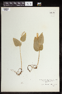 Maianthemum canadense Desfontaines 960487[1318985]Kaliher, Earl L. 1927-06-30 United States, Minnesota, Todd |
MIN:Plants | 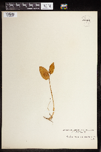 Maianthemum canadense Desfontaines 960486[1318986]Kramer, Leona 1927-00-00 United States, Minnesota, Mower |
MIN:Plants | 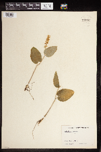 Maianthemum canadense Desfontaines 960485[1318987]Kramer, Leona 1927-00-00 United States, Minnesota, Mower |
MIN:Plants | 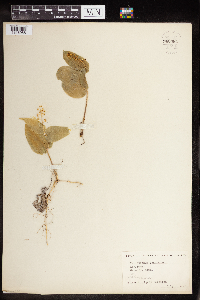 Maianthemum canadense Desfontaines 960484[1318988]Harrigan, Agnes 1924-07-00 United States, Minnesota |
MIN:Plants | 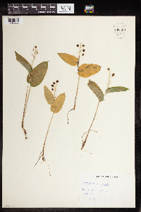 Maianthemum canadense Desfontaines 960483[1318989] 1948-07-25 United States, Minnesota, Red Lake Reservation, 48.0833 -95.0833 |
MIN:Plants | 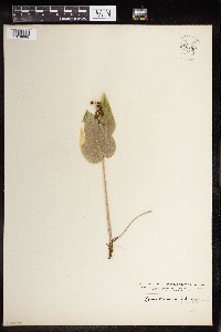 Maianthemum canadense Desfontaines 960482[1318990]Stork, H.E. 1925-00-00 United States, Minnesota, Itasca |
Google Map
Google Maps is a web mapping service provided by Google that features a map that users can pan (by dragging the mouse) and zoom (by using the mouse wheel). Collection points are displayed as colored markers that when clicked on, displays the full information for that collection. When multiple species are queried (separated by semi-colons), different colored markers denote each individual species.