University of Minnesota
http://www.umn.edu/
612-625-5000
http://www.umn.edu/
612-625-5000
Minnesota Biodiversity Atlas
Bell Museum
Dataset: MIN-Plants
Taxa: Brassicaceae
Search Criteria: excluding cultivated/captive occurrences
Bell Museum plants | |
 MIN:Plants | 491539[]Schimpf, D. DJS3342003-05-29 United States, California, Los Angeles, Los Angeles County, Long Beach, T4S R12W Sec 34 ... Approx. 5500 E Pacific Coast Hwy.;;004S;12W;34, 33.7805557 -118.1286087 |
MIN:Plants | Boechera laevigata (Muhlenberg ex Willdenow) Al-Shehbaz 973381[1398934]Lee, Michael United States, Minnesota, Winona, Detailed locality information protected. This is typically done to protect rare or threatened species localities. |
MIN:Plants | Boechera laevigata (Muhlenberg ex Willdenow) Al-Shehbaz 973380[1398933]Lee, Michael United States, Minnesota, Fillmore, Detailed locality information protected. This is typically done to protect rare or threatened species localities. |
MIN:Plants | Boechera laevigata (Muhlenberg ex Willdenow) Al-Shehbaz 977256[1402840]Lee, Michael United States, Minnesota, Fillmore, Detailed locality information protected. This is typically done to protect rare or threatened species localities. |
MIN:Plants | Draba aureola S. Watson 529338[]Gillett, G. 1401952-08-02 United States, California, Shasta, Lassen Volcanic National Park...south of 1915 Black Dacite flow...Summit area of Lassen Peak...Shasta County;Lassen Volcanic National Park, 122m |
MIN:Plants | Draba cana Rydberg 298306[]Mexia, Ynes United States, Alaska, Detailed locality information protected. This is typically done to protect rare or threatened species localities. |
MIN:Plants | Draba cana Rydberg 403533[]Spetzman, L. United States, Alaska, Detailed locality information protected. This is typically done to protect rare or threatened species localities. |
MIN:Plants | Draba cana Rydberg 436763[1352955]Scott, P. United States, Minnesota, Lake, Detailed locality information protected. This is typically done to protect rare or threatened species localities. |
MIN:Plants | Draba cana Rydberg 487960[1352956]Lee, Michael; et al. United States, Minnesota, Cook, Detailed locality information protected. This is typically done to protect rare or threatened species localities. |
MIN:Plants | Draba cana Rydberg 922536[1352954]et al.; Gerdes, Lynden United States, Minnesota, Lake, Detailed locality information protected. This is typically done to protect rare or threatened species localities. |
MIN:Plants | Draba cana Rydberg 936783[1352953]Anderson, Chel; Rowe, Erika United States, Minnesota, Lake, Detailed locality information protected. This is typically done to protect rare or threatened species localities. |
MIN:Plants | Streptanthus tortuosus Kellogg 232869[]Congdon, J. s.n.1888-05-21 United States, California, Mariposa, Yosemite Region, Mariposa County;Yosemite National Park |
MIN:Plants | Streptanthus tortuosus Kellogg 233099[]Congdon, J. s.n.1899-08-28 United States, California, Mariposa, Tenaya Trail, Indian Canyon, Mariposa County;Yosemite National Park |
MIN:Plants | Streptanthus tortuosus Kellogg 232838[]Congdon, J. s.n.1895-05-16 United States, California, Mariposa, Aqua Fria Canyon, Mariposa County;Yosemite National Park |
MIN:Plants | Streptanthus tortuosus Kellogg 225470[]Abrams, Le Roy 44981911-06-23 United States, California, Mariposa, Yosemite National Park...Yosemite Valley;Yosemite National Park;;;, 37.92687 -119.50378, 1372m |
MIN:Plants | Draba cana Rydberg 960711[1329316]Lee, Michael United States, Minnesota, Cook, Detailed locality information protected. This is typically done to protect rare or threatened species localities. |
MIN:Plants | Streptanthus tortuosus Kellogg 460952[]Michener; et al. 191893-06-07 United States, California, Sonoma, Sonoma County...Hood's Peak |
MIN:Plants | Streptanthus tortuosus Kellogg 232835[]Congdon, J. s.n.1898-08-03 United States, California, Mariposa, Bridal Veil Trail, Mariposa County;Yosemite National Park |
MIN:Plants | Streptanthus tortuosus Kellogg 121131[]Sonne, C. 191891-07-00 United States, California, Nevada, Sierra Nevada Mountains...Above Donner Lake, Nevada Co. |
MIN:Plants | Streptanthus tortuosus Kellogg 233060[]Congdon, J. s.n.1885-06-01 United States, California, Mariposa, Hite's Cove, Mariposa County;Yosemite National Park;;;, 37.82714 -119.54224 |
MIN:Plants | Streptanthus tortuosus Kellogg 232816[]Congdon, J. s.n.1883-05-31 United States, California, Mariposa, Aqua Fria Canyon, Mariposa County;Yosemite National Park |
MIN:Plants | Streptanthus tortuosus Kellogg 232844[]Congdon, J. s.n.1885-07-01 United States, California, Mariposa, Yosemite Road, Mariposa County;Yosemite National Park |
MIN:Plants | Streptanthus tortuosus Kellogg 232878[]Congdon, J. s.n.1894-08-14 United States, California, Mariposa, Lake Tenaya Trail, Mariposa County;Yosemite National Park |
MIN:Plants | Streptanthus tortuosus Kellogg 121120[]Michener; et al. s.n.1892-05-30 United States, California, Sonoma, Sonoma Co. ...Hood's Peak |
MIN:Plants | Streptanthus tortuosus Kellogg 233101[]Congdon, J. s.n.1890-08-10 United States, California, Mariposa, Crescent Lake, Mariposa County;Yosemite National Park;;;, 37.56466 -119.53348 |
MIN:Plants | Streptanthus tortuosus Kellogg 232818[]Congdon, J. s.n.1892-04-24 United States, California, Mariposa, Aqua Fria;Yosemite National Park |
MIN:Plants | Streptanthus tortuosus Kellogg 232837[]Congdon, J. s.n.1888-05-25 United States, California, Mariposa, Yosemite Region, Mariposa County;Yosemite National Park |
MIN:Plants | Streptanthus tortuosus Kellogg 233062[]Congdon, J. s.n.1883-07-10 United States, California, Mariposa, Mt. Buckingham Trail, Mariposa County;Yosemite National Park |
MIN:Plants | Streptanthus tortuosus Kellogg 232817[]Congdon, J. s.n.1883-04-00 United States, California, Mariposa, Aqua Fria Canyon, Mariposa County;Yosemite National Park |
MIN:Plants | Streptanthus tortuosus Kellogg 121132[]Sonne, C. 191891-07-00 United States, California, Nevada, Sierra Nevada Mountains...Above Donner Lake, Nevada Co. |
MIN:Plants | 800675[]Garton, C. 239591987-08-04 Canada, Ontario, Thunder Bay, Thunder Bay Distr. ...Back yards along HEPC ft. of way on Dorothy St. Kakabeka Falls, Paipoonge Twp.;;;;, 48.4 -89.6166667 |
MIN:Plants | 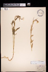 972687[1398240]Blytt s.n. Norway |
MIN:Plants | Draba albertina Greene 118894[]Coville, Frederick; Funston, Frederick 15681891-08-08 United States, California, Tulare, Near Mineral King, Sierra Nevada. Tulare County;Sequoia National Park |
MIN:Plants | Draba albertina Greene 585841[]Porter, C.; et al. 93131963-06-20 United States, Wyoming, Teton, Teton County. Grand Teton National Park...Pacific Creek near Moran.;Grand Teton National Park, 2042m |
MIN:Plants | Draba albertina Greene 580486[]Hunnewell, F. 31051914-08-17 United States, Wyoming, Park, Yellowstone National Park...by Yellowstone Lake;Yellowstone National Park |
MIN:Plants | Cardamine breweri S. Watson 118147[]Burglehaus, F. s.n.1894-08-26 United States, Wyoming, Park, Yellowstone Park...near Mammoth Hot Springs;Yellowstone National Park, 2134m |
MIN:Plants | Cardamine breweri S. Watson 118442[]Nelson, Aven; et al. 56541899-07-03 United States, Wyoming, Park, Yellowstone National Park...Mammoth Hot Springs;Yellowstone National Park |
MIN:Plants | 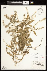 Rorippa palustris (L.) Besser 453716[1134507]Moore, John 6271971-10-08 United States, Minnesota, Sherburne, NW1/4 S-19 Santiago Twnshp.;;035N;28W;19, 45.508388 -93.871722 |
MIN:Plants | 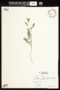 Rorippa palustris (L.) Besser 478504[1134544]Wheeler, Gerald 173971997-08-29 United States, Minnesota, Renville, Birch Coulee State Memorial Park. Renville County ... Ca. 1.5 mi. NE of Morton; S of Rt. 2; Birch Coulee State Memorial Park ... along creek ... NW1/4 NW1/4 Sec. 28 T113N R34W (Birch Cooley 28). 113N 34W 28, 44.563403 -94.944223 |
MIN:Plants | 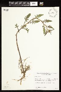 Rorippa palustris (L.) Besser 489368[1134527]Gerdes, Lynden; et al. 34561999-06-15 United States, Minnesota, Cook, Superior National Forest. T64N R03E S01NW Cook County ... Superior National Forest. Northeastern tip of the larger, upland island in the northern portion of South Fowl Lake; just north of campsite.. 064N 03E 1, 48.057227 -90.005821 |
MIN:Plants |  Rorippa palustris (L.) Besser 432689[1134551]Gerdes, Lynden 35781999-07-10 United States, Minnesota, Cook, Superior National Forest. T65N R04W S26. Cook County...Superior National Forest. West of active gravel pit; approximately .25 mile north of the Gunflint Trail (Cty. 12) & FR1347 junction; west off FR1347.. 065N 04W 26, 48.084497 -90.803753 |
MIN:Plants |  Rorippa palustris (L.) Besser 920293[1134513]Smith, Welby 257671995-07-18 United States, Minnesota, Pipestone, Split Rock Creek State Park. about 7 miles south-southwest of Pipestone. Split Rock Creek. NW1/4 of SW1/4 of Section T105N R46W NW1/4 of SW1/4 of Sec 15. 105N 46W 15, 43.8986111 -96.3638889 |
MIN:Plants |  Rorippa palustris (L.) Besser 493720[1134528]Gerdes, Lynden 36731999-08-02 United States, Minnesota, Cook, Superior National Forest. T65N R04W S26SWNE. Cook County...Superior National Forest, Gunflint Trail area. Cross River gravel/sand pit ~0.2 mile north of the Gunflint Trail (Cty. 12) and FR 1347 junction. Wet, western edge of west pit.. 065N 04W 26, 48.084497 -90.803753 |
MIN:Plants |  Rorippa palustris (L.) Besser 492560[1134543]Capistrant, A. AMC13561998-07-22 United States, Minnesota, Ramsey, [no further data];;029N;22W;21, 44.9847716 -93.0559436 |
MIN:Plants |  Rorippa palustris (L.) Besser 492346[1134509]Capistrant, A. AMC15641998-08-05 United States, Minnesota, Carver, [no further data];;116N;23W;16, 44.855973 -93.592079 |
MIN:Plants |  Rorippa palustris (L.) Besser 429936[1134524]Addison, B. s.n.1994-06-00 United States, Minnesota, Anoka, Rice Creek Gardens, Blaine.;;031N;23W;17, 45.1754 -93.234994 |
MIN:Plants |  Rorippa palustris (L.) Besser 337026[1134535]Lakela, Olga 15011936-07-09 United States, Minnesota, Saint Louis, On Oatka Beach Addition, gravel flat pumped from St. Louis Bay, Duluth.;Minnesota Point;049N;13W;18, 46.741215 -92.062388 |
MIN:Plants |  Rorippa palustris (L.) Besser 352708[1134533]Eneboe, H. 571937-06-28 United States, Minnesota, Hennepin, Barge terminal, Mississippi River flats, S of Washington Avenue bridge, Minneapolis.;;029N;24W;25, 44.969959 -93.237021 |
MIN:Plants |  Rorippa palustris (L.) Besser 356117[1134554]Lakela, Olga 31701939-07-20 United States, Minnesota, Saint Louis, Adjoining the recreational grounds, Minnesota Point, Duluth.;Minnesota Point;N;;, 46.741215 -92.062388 |
MIN:Plants |  Rorippa palustris (L.) Besser 356963[1134534]Stevenson, J. 3511912-08-22 United States, Minnesota, Itasca, Grand Rapids;;055N;25W;, 47.215547 -93.522987 |
MIN:Plants |  Rorippa palustris (L.) Besser 373661[1134557]Lakela, Olga 50631942-06-23 United States, Minnesota, Carlton, Ditch along r.r. tracks. Holyoke.;;N;;, 46.467443 -92.388528 |
MIN:Plants |  Rorippa palustris (L.) Besser 373790[1134542]Moore, John; et al. 150191941-08-08 United States, Minnesota, Aitkin, 1 mi. W of Aitkin. Aitkin Co.;;047N;27W;, 46.547376 -93.745854 |
MIN:Plants |  Rorippa palustris (L.) Besser 385619[1134555]Moyle, J. 40591945-08-29 United States, Minnesota, Fillmore, Fillmore Co. Whalen. Along the Root River.;Dorer Memorial Hardwood State Forest;103N;09W;, 43.716976 -91.909804 |
MIN:Plants | 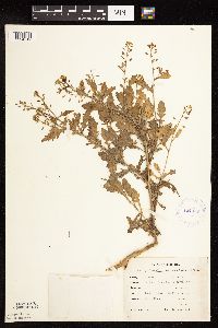 Rorippa palustris (L.) Besser 424049[1134512]Emanuel, J. 1901946-09-10 United States, Minnesota, Itasca, County: Itasca. Locality: Nashwauk Township (McCarty Lake).;;057N;23W;21, 47.406646 -93.270038 |
MIN:Plants | 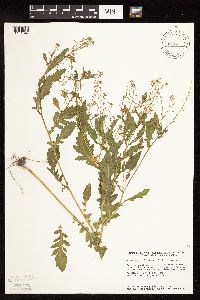 Rorippa palustris (L.) Besser 427448[1134547]Smith, Welby 148651988-08-17 United States, Minnesota, Meeker, Meeker Co. At the W end of Minnesota Lake, about 3 mi SW of Litchfield; at the public access; SW1/4 NW1/4 sec.34, T119N Meeker Co. At the W end of Minnesota Lake, about 3 mi SW of Litchfield; at the public access; SW1/4 NW1/4 sec.34, T119N R31W. 119N 31W 34, 45.0750008 -94.5602798 |
MIN:Plants | 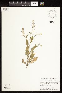 Rorippa palustris (L.) Besser 440532[1134501]Smith, Welby 149201988-08-17 United States, Minnesota, Meeker, Meeker Co. About 3.5 mi W of Kingston; along the North Fork Crow River, near the Hwy.27 crossing; SW1/4 NE1/4 sec.13, t1 Meeker Co. About 3.5 mi W of Kingston; along the North Fork Crow River, near the Hwy.27 crossing; SW1/4 NE1/4 sec.13, t120N R30W. 120N 30W 13, 45.2036095 -94.3880539 |
MIN:Plants | 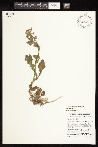 Rorippa palustris (L.) Besser 447435[1134518]Husveth, J. 96-0571996-05-18 United States, Minnesota, Wabasha, Wabasha Co. T110N R11W SW1/4 of the sE1/4 of S12; Bank of the Zumbro River;Dorer Memorial Hardwood State Forest;110N;11W;12, 44.344416 -92.079071 |
MIN:Plants |  Rorippa palustris (L.) Besser 453228[1134504]Smith, Welby 146611988-08-04 United States, Minnesota, Mille Lacs, Mille Lacs County...About 11 miles north of Milaca...Rum River...SW1/4 SE1/4 section 26, T 40N R 27W;;040N;27W;26, 45.925 -93.6680556 |
MIN:Plants |  Rorippa palustris (L.) Besser 504920[1134525]Nation, R. 94-1781994-06-30 United States, Minnesota, Mower, Lake Louise State Park. Lake Louise State Park. Mower County...Tract #1A, S of the Old Minnesota Highway 56 road bed. T101N R14W E1/2 SW1/4 of Sec.21. 101N 14W 21, 43.536578 -92.519043 |
MIN:Plants |  Rorippa palustris (L.) Besser 514347[1134519]Smith, Welby 156241989-07-09 United States, Minnesota, Roseau, Roseau Co.; about 18 miles northwest of Greenbush; NE1/4 NW1/4 sec.19, T 163N R 44W;;163N;44W;19, 48.9361115 -96.3952789 |
MIN:Plants |  Rorippa palustris (L.) Besser 514536[1134508]Myhre, K. 27301992-07-15 United States, Minnesota, Cass, Cass Co.; located on the E shore of Mabel Lake, NW of the campground; T141N R27W SE1/4 of SE1/4 of Sec 3;Chippewa National Forest;141N;27W;3, 47.058662 -94.083833 |
MIN:Plants |  Rorippa palustris (L.) Besser 515022[1134536]Monson, Paul 60231984-08-02 United States, Minnesota, Cook, Grand Portage National Monument; Cook Co.; R-5E, T-64N, S-26, Ca. 4.5 mi. NW of visitor center.;Grand Portage National Monument / North Shore;064N;05E;26, 47.998261 -89.76966 |
MIN:Plants | 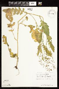 Rorippa palustris (L.) Besser 519831[1134520]Schimpf, D.; et al. 1971983-08-24 United States, Minnesota, Cook, Grand Portage National Monument; Cook Co.; R-5E, T-64N, S-25, about 4 mi. NW of Visitor Center.;Grand Portage National Monument / North Shore;064N;05E;25, 47.998144 -89.748285 |
MIN:Plants |  Rorippa palustris (L.) Besser 527518[1134541]Lakela, Olga 184621954-09-18 United States, Minnesota, Lake, Basswood Lake at the [Quetico-Superior Wilderness] Research Center. Sec. 9, T64N, R10. Lake co.;Boundary Waters Canoe Area Wilderness / Superior National Forest;064N;10W;09, 48.031651 -91.618862 |
MIN:Plants |  Rorippa palustris (L.) Besser 715135[1134556]Severson, M. 1151979-08-13 United States, Minnesota, Polk, (TNC) 4.5 mi. S of Fischer, W1/2 NW1/4 of Sec;Malmberg Prairie Scientific Natural Area;149N;48W;16, 47.72417 -96.813965 |
MIN:Plants |  Rorippa palustris (L.) Besser 728940[1134511]Herman, J. 391979-06-12 United States, Minnesota, Mahnomen, Mahnomen Co. Santee Prairie: 3 mi SE of Bejou, Sec. 6, 7, T145N, R41W.;Santee Prairie Scientific Natural Area / White Earth Indian Reservation;145N;41W;, 47.368425 -95.869122 |
MIN:Plants | 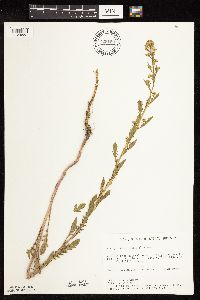 Rorippa palustris (L.) Besser 729199[1134553]Berlin, N. 921979-06-27 United States, Minnesota, Goodhue, Wacouta Pond Natural Area: 5 mi. SE of Red Wing, Portions of: Sec. 6, T112N, R13W and Sec. 31, 32, T113N, R13W.;Wacouta Pond Natural Area, The Nature Conservancy;N;;, 44.535146 -92.41987 |
MIN:Plants | 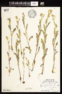 Rorippa palustris (L.) Besser 739511[1134537]Stackler, S. 17521976-07-02 United States, Minnesota, Carlton, Ca. 6 mi. E, 1/2 mi. S, 1/2 mi. E Barnum.;;045N;17W;6, 46.54245 -92.55012 |
MIN:Plants | 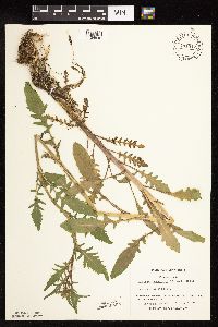 Rorippa palustris (L.) Besser 741312[1134540]Converse, C. 10061982-06-07 United States, Minnesota, Douglas, Staffanson Prairie;Staffanson Prairie, The Nature Conservancy;127N;40W;18, 45.810665 -95.748005 |
MIN:Plants | 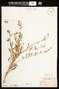 Rorippa palustris (L.) Besser 763760[1134538]Burglehaus, F. s.n.1892-08-00 United States, Minnesota, Hennepin, Minneapolis;;N;;, 44.979965 -93.263836 |
MIN:Plants |  Rorippa palustris (L.) Besser 773693[1134505]Boe, J. 6571979-07-10 United States, Minnesota, Lake of the Woods, Lake of the Woods County...Rocky Point...near summer homes...(NW1/2 Sec. 8, R34W, T163N);;163N;34W;08, 48.952145 -95.059118 |
MIN:Plants |  Rorippa palustris (L.) Besser 782420[1134532]Tenney, M. 2581982-06-22 United States, Minnesota, Winona, Whitewater State Park. Winona Co. T107N, R10W, Sec. 19, NE1/2 NE1/4 SE1/4.;Whitewater State Park;107N;10W;19, 44.056381 -92.069193 |
MIN:Plants |  Rorippa palustris (L.) Besser 782508[1134531]Tenney, M. 2821982-06-29 United States, Minnesota, Winona, Whitewater State Park. Winona Co. T107N, R10W, Sec. 29, SW1/4 NW1/4 NW1/4;Whitewater State Park;107N;10W;29, 44.042035 -92.049333 |
MIN:Plants |  Rorippa palustris (L.) Besser 793166[1134549]Ownbey, Gerald 71901987-09-02 United States, Minnesota, Koochiching, Koochiching Co.; T70N, R26W, Sec. 34, NE1/4. Bank of Rainy River.;;070N;26W;34, 48.510734 -93.668292 |
MIN:Plants |  Rorippa palustris (L.) Besser 795964[1134499]Smith, Welby 86221983-08-11 United States, Minnesota, Lake of the Woods, Zippel Bay State Park. On the S shore of Lake of the Woods. SE1/4 SW1/4 Sec. 2, T162N, R33W.;Zippel Bay State Park;162N;33W;2, 48.880239 -94.861224 |
MIN:Plants |  Rorippa palustris (L.) Besser 801142[1134548]Smith, Welby 107731985-07-13 United States, Minnesota, Fillmore, Fillmore Co. In the Root River, about 1 mi NE of Lanesboro. SW1/4 SE1/4 Sec. 7, T103N, R10W.;Dorer Memorial Hardwood State Forest;103N;10W;7, 43.738955 -92.07918 |
MIN:Plants |  Rorippa palustris (L.) Besser 814640[1134546]Wheeler, Gerald 114911988-07-27 United States, Minnesota, Lac Qui Parle, Lac Qui Parle Wildlife Management Area. Ca. 6 mi. NNE of Bellingham; Lac Qui Parle WMA. Adjacent to the Minnesota River. N1/2 Sec. 12 T120N, R45W (Agassiz Tw Ca. 6 mi. NNE of Bellingham; Lac Qui Parle WMA. Adjacent to the Minnesota River. N1/2 Sec. 12 T120N, R45W (Agassiz Twp.). 120N 45W 12, 45.214682 -96.23671 |
MIN:Plants |  Rorippa palustris (L.) Besser 814651[1134506]Wheeler, Gerald 108911988-06-26 United States, Minnesota, Traverse, Traverse County...Ca. 5.5 mi. SW of Wheaton; wayside park N of Rte. 27...Mustinka River...W1/2 NE1/4 Sec. 32, T127N, R47W (Lake Twp.). 127N 47W 32, 45.767018 -96.604078 |
MIN:Plants |  Rorippa palustris (L.) Besser 815778[1134552]Wheeler, Gerald 112131988-07-19 United States, Minnesota, Big Stone, Barry Lake Wildlife Management Area. Big Stone Co.; Ca. 1 mi. NW of Barry; ca. 0.7 mi. E of Rte. 57. On the margin of Barry Lake. W1/2 SE1/4 NE1/4 Sec. 8, T124N, R47W (Toqua Twp.).. 124N 47W 8, 45.565691 -96.586118 |
MIN:Plants |  Rorippa palustris (L.) Besser 828601[1134539]Delaney, B. 902171990-08-26 United States, Minnesota, Isanti, Isanti Co.; growing along N bank of Rum River W of Walbo Landing; 5 mi W of Cambridge. NE1/4 SE1/4 sec.28, T36N, R24W;;036N;24W;28, 45.58024 -93.337775 |
MIN:Plants |  Rorippa palustris (L.) Besser 832455[1134510]Moyle, J. 40431945-08-01 United States, Minnesota, Freeborn, Freeborn Co, Albert Lea L.;Albert Lea Wildlife Management Area;102N;21W;, 43.629478 -93.34871 |
MIN:Plants |  Rorippa palustris (L.) Besser 832456[1134530]Moyle, J. 41311945-07-13 United States, Minnesota, Traverse, Traverse Co. Shore of Lake Traverse;;;;, 45.696005 -96.745148 |
MIN:Plants |  Rorippa palustris (L.) Besser 840379[1134500]Smith, Welby 136121987-07-27 United States, Minnesota, Washington, Rice Lake Wildlife Management Area. Washington Co. Rice Lake State Wildlife Management Area, about 1 mi E of Hugo. SE1/4 NE1/4 sec.21, T31N R21W, Washington Co. Rice Lake State Wildlife Management Area, about 1 mi E of Hugo. SE1/4 NE1/4 sec.21, T31N R21W, at the edge of Rice Lake.. 031N 21W 21, 45.1611099 -92.9625015 |
MIN:Plants |  Rorippa palustris (L.) Besser 841750[1134502]Smith, Welby 137001987-08-04 United States, Minnesota, Washington, Washington Co. About 12 mi NW of Marine on St. Croix; NW1/4 NW1/4 sec.28, T32N R21W;;032N;21W;28, 45.232068 -92.96821 |
MIN:Plants | 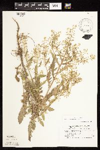 Rorippa palustris (L.) Besser 518974[1134521]Smith, Welby 210751992-07-23 United States, Minnesota, Le Sueur, Le Sueur County...About one mile east of Elysian, on the north side of Highway 60...T109N R23W SW1/4 of SW1/4 of Sec 31;;109N;23W;31, 44.1983333 -93.6436111 |
MIN:Plants |  Rorippa palustris (L.) Besser 670757[1134522]Heitlinger, M. 6171972-07-18 United States, Minnesota, McLeod, McLeod County, Schaefer Prairie...SE 1/4 of Sec. 34, T 115N, R29W...drainage ditch leading into Buffalo Creek.;Schaefer Prairie, The Nature Conservancy;115N;29W;34, 44.72505 -94.30491 |
MIN:Plants |  Rorippa palustris (L.) Besser 759151[1134523]Smith, Welby 70071982-07-30 United States, Minnesota, Mower, Brandt-Larson Wildlife Management Area. Mower County...Brandt-Larson State Wildlife Management Area. About 4 mi. NE of Lyle...Otter Creek. NE1/4 SW1/4 Sec. 16, T101N, R17W.. 101N 17W 16, 43.550746 -92.878835 |
MIN:Plants |  Rorippa palustris (L.) Besser 726318[1134515]Smith, Welby 29151980-07-20 United States, Minnesota, Wright, on S bank of Mississippi River, about 1/4 mi E of Clearwater. SE1/4 SE1/4 Sec.;;123N;27W;35, 45.416899 -94.04856 |
MIN:Plants | 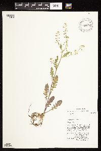 Rorippa palustris (L.) Besser 816705[1134514]Welling, C. CW90-0631990-08-02 United States, Minnesota, Ramsey, Soil from the wetland immediately north of Minnesota State Highway 96 and 0.6 km E of Highway 61, section 12 of White Bear township, Ramsey County. 030N 22W 12, 45.101081 -92.99472 |
MIN:Plants | 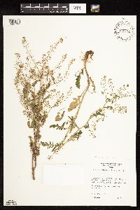 Rorippa palustris (L.) Besser 835401[1134558]Monson, Paul 50051974-07-24 United States, Wisconsin, Buffalo, Buffalo Co. R-13W, T-22N. Mississippi R. backwaters area, SE of Wabasha, MN. |
MIN:Plants | 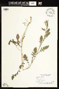 Rorippa palustris (L.) Besser 473605[1134517]Nation, R. 94-1031994-06-21 United States, Minnesota, Mower, Lake Louise State Park. Mower Co.; Tract #13N. T101N R14W NE1/4 of SE1/4 of Sec. 21;Lake Louise State Park;101N;14W;21, 43.53658 -92.51904 |
MIN:Plants |  Rorippa palustris (L.) Besser 468588[1183265]Shimek, B. s.n.1916-07-12 United States, Iowa, Dickinson, Swamp north of old mail box. S.W. 1/4 Sec. 23-99-37. Dickinson County.;;099N;37W;23 |
MIN:Plants | 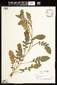 Rorippa palustris (L.) Besser 473603[1134516]Nation, R. 94-1271994-06-21 United States, Minnesota, Mower, Lake Louise State Park. Mower Co.; Tract #22A. T101N R14W NE1/4 of Sec. 21;Lake Louise State Park;101N;14W;21, 43.536578 -92.519043 |
MIN:Plants | 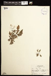 Rorippa palustris (L.) Besser 399279[1183264]Spetzman, L. 4001947-07-28 United States, Alaska, Canning River ... bottom of big bluff in the valley across the river;Arctic National Wildlife Refuge;;;, 69.2833333 -146.0166667 |
MIN:Plants | 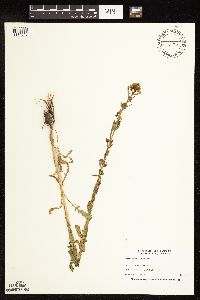 Rorippa palustris (L.) Besser 473606[1134545]Nation, R. 94-0801994-06-08 United States, Minnesota, Mower, Lake Louise State Park. Mower Co.; Tract #3B. T101N R14W NW1/4 of SW1/4 of Sec. 21;Lake Louise State Park;101N;14W;21, 43.536578 -92.519043 |
MIN:Plants | 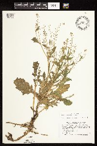 Rorippa palustris (L.) Besser 477208[1134503]Smith, Welby 17101A1990-06-28 United States, Minnesota, Waseca, Waseca County ... At the north end of Buffalo Lake, about 3 miles south of Janesville ... T107N R24W NE1/4 of NE1/4 of Sec 20. 107N 24W 20, 44.0658333 -93.73 |
MIN:Plants | 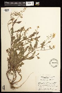 Rorippa palustris (L.) Besser 528338[1183263]Garton, C. 18121952-07-10 Canada, Ontario, Thunder Bay, Thunder Bay District...Farm 1-1/2 miles northeast of Little Pigeon Bay, on Pine Bay Road, Crooks Township |
MIN:Plants |  Rorippa palustris (L.) Besser 432722[1134529]Gerdes, Lynden; et al. 34561999-06-15 United States, Minnesota, Cook, Superior National Forest. T64N R03E S01NW. Cook County...Superior National Forest. Northeastern tip of the larger, upland island in the northern portion of South Fowl Lake; just north of campsite.. 064N 03E 1, 48.057227 -90.005821 |
MIN:Plants | 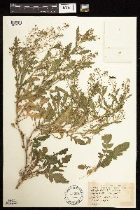 Rorippa palustris (L.) Besser 489805[1183266]Stevens, O. s.n.1933-09-18 United States, North Dakota, Cass, Fargo. |
MIN:Plants | 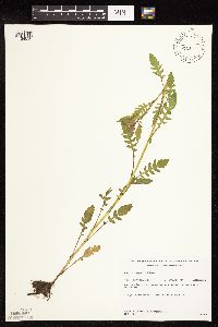 Rorippa palustris (L.) Besser 432201[1134550]Gerdes, Lynden; et al. 34871999-06-23 United States, Minnesota, Cook, Superior National Forest. T65N R02W S19SENE. Cook County...Superior National Forest. Northeast corner of the most southeastern bay of Gunflint Lake.. 065N 02W 19, 48.098709 -90.630416 |
Google Map
Google Maps is a web mapping service provided by Google that features a map that users can pan (by dragging the mouse) and zoom (by using the mouse wheel). Collection points are displayed as colored markers that when clicked on, displays the full information for that collection. When multiple species are queried (separated by semi-colons), different colored markers denote each individual species.