University of Minnesota
http://www.umn.edu/
612-625-5000
http://www.umn.edu/
612-625-5000
Minnesota Biodiversity Atlas
Bell Museum
Dataset: MIN-Plants
Taxa: Lycopodiaceae
Search Criteria: excluding cultivated/captive occurrences
Bell Museum plants | |
 MIN:Plants |  371700[1339874]Lakela, Olga 48091941-08-17 United States, Minnesota, Lake, At S.N. Forest Lodge. Lake Co.;Superior National Forest;N;;, 47.75 -91.5 |
MIN:Plants |  371932[1339910]Lakela, Olga 48331941-08-19 United States, Minnesota, Saint Louis, Lake Vermilion near Soudan. St. Louis Co.;;N;;, 47.891581 -92.366824 |
MIN:Plants |  383510[1339876]Moore, John W. 161061943-09-07 United States, Minnesota, Lake, Palisade Head, Lake Co.;North Shore / Palisade Head;056N;07W;22, 47.323861 -91.212348 |
MIN:Plants |  387750[1339869]Butters, F.K. 809a1944-07-30 United States, Minnesota, Cook, Cook Co. Between South Lake and Partridge Lake. T65N R2W;Boundary Waters Canoe Area Wilderness / Superior National Forest;065N;02W;, 48.084387 -90.488868 |
MIN:Plants | 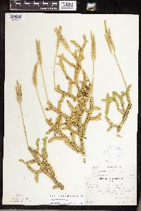 387751[1339837]Butters, F.K. 809b1944-07-30 United States, Minnesota, Cook, Cook Co. Between South Lake and Partridge Lake. T65N R2W;Boundary Waters Canoe Area Wilderness / Superior National Forest;065N;02W;, 48.084387 -90.488868 |
MIN:Plants | 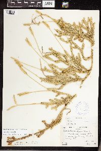 387753[1339868]Butters, F.K. 8861944-08-02 United States, Minnesota, Cook, Cook Co. Along trail to Lima Mt. T64N R1W;Superior National Forest;064N;01W;, 47.726653 -90.386005 |
MIN:Plants | 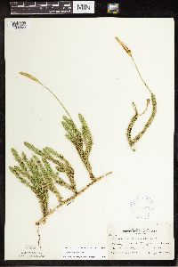 387756[1339923]Lakela, Olga 56981944-08-13 United States, Minnesota, Cook, At Temperance River, Cook Co.;North Shore / Temperance River State Park;059N;04W;, 47.557593 -90.875149 |
MIN:Plants | 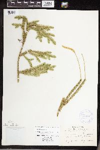 388059[1339842]Lakela, Olga 56981944-08-13 United States, Minnesota, Cook, At Temperance River, Cook Co.;North Shore / Temperance River State Park;059N;04W;, 47.557593 -90.875149 |
MIN:Plants | 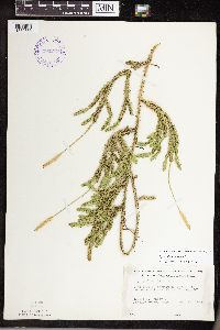 393273[1339835]Ownbey, Gerald 9971948-08-11 United States, Minnesota, Cook, Cook County...Near Temperance River Falls, Hwy.#61;North Shore / Temperance River State Park;059N;04W;, 47.557593 -90.875149 |
MIN:Plants | 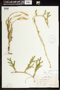 407291[1339916]Lakela, Olga 98121949-09-12 United States, Minnesota, Saint Louis, Near Jasper Peak [now Chester Peak], [highway] #1. Soudan. St. Louis Co.;;062N;15W;36, 47.8 -92.2 |
MIN:Plants | 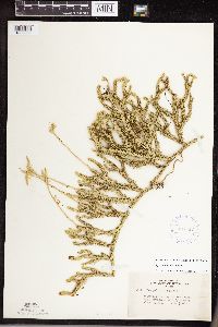 407627[1339908]Lakela, Olga 83321949-06-20 United States, Minnesota, Saint Louis, Along railroad right-away, Armstrong Lake.;;062N;14W;, 47.850158 -92.075839 |
MIN:Plants | 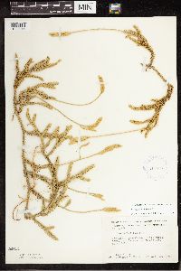 412959[1339946]Moore, John 119241939-08-19 United States, Minnesota, Koochiching, Koochiching Co. 1 mi west of Tilson Bay, Rainy Lake.;;071N;23W;, 48.606604 -93.401815 |
MIN:Plants | 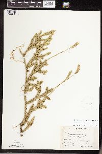 419339[1339840]Briggs, John De Q. 1211945-08-03 United States, Minnesota, Cook, Cook Co. Sawbill Laek, T62N R4W;Boundary Waters Canoe Area Wilderness / Superior National Forest;062N;04W;, 47.88583 -90.87778 |
MIN:Plants | 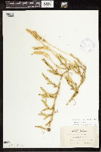 419930[1339944]Lakela, Olga 98231949-08-30 United States, Minnesota, Koochiching, On road to Black Bay, Rainy River, Koochiching Co.;;;;, 48.5667 -93.15 |
MIN:Plants | 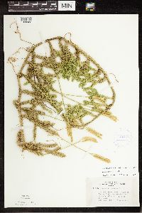 421303[1339922]Lakela, Olga 117901950-08-26 United States, Minnesota, Saint Louis, Lac La Croix, 8 mi W of Curtain Falls, St. Louis Co.;Boundary Waters Canoe Area Wilderness / Superior National Forest;N;;, 48.3333 -92.1167 |
MIN:Plants | 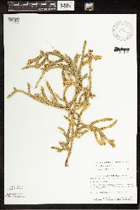 428336[1339935]Smith, Welby 138831987-08-19 United States, Minnesota, Lake, Lake County...In the BWCAW, Superior National Forest; at the NE end of Makwa Lake. SE1/4 SW1/4 sec.23, T64N R6W;Boundary Waters Canoe Area Wilderness / Superior National Forest;064N;06W;23, 48.011561 -91.056073 |
MIN:Plants |  430633[1311308]Smith, Welby 195341991-07-16 United States, Minnesota, Koochiching, Koochiching State Forest. Koochiching County...On the north side of TH 65, about 18 miles northwest of Silverdale... T 65N R 24W SE1/4 of NE1/4 of Sec 3. 065N 24W 3, 48.1333351 -93.4186096 |
MIN:Plants |  442758[1339912]Lakela, Olga 131181951-07-11 United States, Minnesota, Saint Louis, Trailside to Rainy Lake about 1 mi from Kettle Falls, St. Louis Co.;Voyageurs National Park;070N;18W;, 48.49944 -92.63889 |
MIN:Plants |  442829[1339913]Lakela, Olga 129931951-07-10 United States, Minnesota, Saint Louis, A point on Namakan Lake at Kettle Falls, St. Louis Co.;Voyageurs National Park;070N;18W;, 48.49944 -92.63889 |
MIN:Plants |  462516[1339929]Lakela, Olga 158081952-09-11 United States, Minnesota, Saint Louis, St. Louis Co. Sand Point Lake W of Harrison's Narrows;Voyageurs National Park;N;;, 48.483546 -92.838098 |
MIN:Plants |  462847[1339871]Lakela, Olga 153121952-07-26 United States, Minnesota, Saint Louis, St. Louis Co. SE corner of the county, on old North Shore road;;N;;, 46.903742 -92.335123 |
MIN:Plants |  473655[1311305]Myhre, K. 16051992-04-27 United States, Minnesota, Cass, Cass Co.; 2 mile south of Lake Winnibigoshish; T 146N R 27W SE1/4 of SW1/4 of Sec 35;Chippewa National Forest / Leech Lake Indian Reservation;146N;27W;35, 47.414111 -94.069312 |
MIN:Plants |  492974[1339918]Lakela, Olga 167501953-08-09 United States, Minnesota, Saint Louis, St. Louis County...Bottle Lake portage to Lac la Croix;Boundary Waters Canoe Area Wilderness / Superior National Forest;067N;13W;34, 48.3333 -92.1167 |
MIN:Plants |  508253[1339948]Myhre, K. 34721993-04-22 United States, Minnesota, Pine, Pine Co.; located 1/2 mi NE Nickerson; T45N R17W NE1/4 of NE1/4 of Sec 4;;045N;17W;4, 46.410467 -92.498314 |
MIN:Plants |  520072[1311303]Smith, Welby 195961991-07-17 United States, Minnesota, Itasca, Itasca Co.; Scenic State Park, about 3 mi SE of Big Fork; T60N R26W NE1/4 of NE1/4 of Sec 1;Scenic State Park;060N;26W;1, 47.7213898 -93.5805588 |
MIN:Plants |  525850[1339953]Lakela, Olga 190181955-08-03 United States, Minnesota, Saint Louis, St. Louis Co. Johnson's Lake, S of Namakan Lake. R68 T18.;Voyageurs National Park;068N;18W;, 48.433517 -92.705646 |
MIN:Plants |  526828[1339898]Lakela, Olga 181971954-08-14 United States, Minnesota, Lake, Above Chippewa Lake S of Friday Bay, Lake Co.;Boundary Waters Canoe Area Wilderness / Superior National Forest;066N;11W;31, 48.156545 -91.788226 |
MIN:Plants |  527235[1339930]Lakela, Olga 179991954-07-24 United States, Minnesota, Saint Louis, St. Louis County...On Moose [=Moose Camp] Lake portage from Gun Lake;Boundary Waters Canoe Area Wilderness / Superior National Forest;T065N R12W S13, 48.114819 -91.809779 |
MIN:Plants |  532331[1339895]Lakela, Olga 198531956-06-16 United States, Minnesota, Saint Louis, St. Louis Co. S side of Seven Beaver Lake, headwaters of St. Louis River.;Superior National Forest;058N;12W;, 47.499159 -91.811429 |
MIN:Plants |  533108[1339909]Lakela, Olga 206951956-08-07 United States, Minnesota, Saint Louis, St. Louis County...Above Bullet Lake; Superior National Forest, N of Ely.;Boundary Waters Canoe Area Wilderness / Superior National Forest;065N;12W;12, 48.1167 -91.8 |
MIN:Plants |  543166[1339847]Lakela, Olga 216951957-07-26 United States, Minnesota, Lake, Lake Co. Tomahawk Trail W of Isabella Lake;Boundary Waters Canoe Area Wilderness / Superior National Forest;062N;08W;35, 47.800713 -91.52116 |
MIN:Plants |  543514[1339896]Lakela, Olga 220451957-08-17 United States, Minnesota, Lake, Lake Co. Hwy.#2, 35 mi N of Two Harbors;Superior National Forest;N;;, 47.529375 -91.670732 |
MIN:Plants |  543599[1339862]Lakela, Olga 224731957-09-13 United States, Minnesota, Lake, Lake Co. Snow Bank Lake, at the lodge area.;Boundary Waters Canoe Area Wilderness / Superior National Forest;N;;, 47.988692 -91.416956 |
MIN:Plants |  55149[1339864]Moyer, Lycurgus s.n. United States, Minnesota, Saint Louis, Virginia;;N;;, 47.53779 -92.552714 |
MIN:Plants |  55171[1339880]Lyon 291902-05-17 United States, Minnesota, Clearwater, Lake Itasca;Itasca State Park;143N;36W;00, 47.19557 -95.23322 |
MIN:Plants |  55172[1339945]Sheldon, Edmund S29951892-07-00 United States, Minnesota, Mille Lacs, Milaca;;N;;, 45.755799 -93.654408 |
MIN:Plants |  55173[1339885]Anderson, A. A525 1/21893-07-00 United States, Minnesota, Cass, Gull Lake. Cass Co.;;N;;, 46.446379 -94.35099 |
MIN:Plants |  55174[1339940]Arthur, J.C. 31A1886-07-19 United States, Minnesota, Saint Louis, Vermillion Lake, 47.891581 -92.366824 |
MIN:Plants |  55176[1339872]Lugger, O. s.n.1891-00-00 United States, Minnesota, Saint Louis, Tower;;N;;, 47.805475 -92.274605 |
MIN:Plants |  55177[1339959]Arthur, J.C. 98A1886-07-21 United States, Minnesota, Saint Louis, Vermillion Lake, 47.891581 -92.366824 |
MIN:Plants |  55178[1339886]MacMillan, C. M&S341890-08-00 United States, Minnesota, Cass, Lake Kilpatrick, Cass Co.;;135N;29W;00, 46.50016 -94.32908 |
MIN:Plants |  55179[1339911]Roberts, Thomas s.n.1878-07-00 United States, Minnesota, Saint Louis, French River;;N;;, 46.942992 -91.949958 |
MIN:Plants |  55180[1339938]Rosendahl, C. 43121922-07-00 United States, Minnesota, Clearwater, Itasca State Park.;Itasca State Park;143N;36W;, 47.197458 -95.201964 |
MIN:Plants |  564942[1339834]Cotter, Shirley 3441948-08-06 United States, Minnesota, Clearwater, Garrison Point Bog, Itasca Park, Clearwater Co.;Itasca State Park;143N;36W;, 47.197458 -95.201964 |
MIN:Plants |  576158[1339902]Tucker, Shirley C. 42921959-06-28 United States, Minnesota, Clearwater, N boundary of Itasca Park; Clearwater Co.;Itasca State Park;143N;36W;, 47.197458 -95.201964 |
MIN:Plants |  578823[1339843]Ownbey, Gerald 31401962-06-19 United States, Minnesota, Clearwater, Clearwater Co. Iron Springs Bog, 1 mi N of Itasca State Park. T144N, R36W, SW1/4 Sec.28.;Iron Springs Bog Scientific Natural Area;144N;36W;28, 47.260649 -95.244129 |
MIN:Plants |  583278[1339863]Kellner, H. 3061956-08-10 United States, Minnesota, Lake, Lake Co. At station 5, Shovel Pt. site.;North Shore / Tettegouche State Park;056N;07W;14, 47.33958 -91.198054 |
MIN:Plants |  583279[1339855]Kellner, H. 5001956-07-13 United States, Minnesota, Lake, Lake Co. Atop Silver Cliff;;N;;, 47.06882 -91.592398 |
MIN:Plants |  583290[1339931]Kellner, H. 3471956-07-17 United States, Minnesota, Lake, Lake County...Along Cathedral Cliff, Encampment Forest.;North Shore;053N;10W;11, 47.079941 -91.618995 |
MIN:Plants |  588041[1339844]Marion, J. s.n.1982-00-00 United States, Minnesota, Cook, Cook Co, North Shore of Lake Superior, ca. 200 ft. from lakeshore.;North Shore;;;, 47.46396 -91.02551 |
MIN:Plants |  590212[1339866]Voss, E. 100611961-07-16 United States, Minnesota, Lake, Lake County...Near S end of Cloquet Lake, Sec. 9-16, T57N R9W, ca. 14 mi W of Finland.;Superior National Forest;057N;09W;09, 47.437098 -91.48128 |
MIN:Plants |  603608[1339891]Moore, John 268791966-06-10 United States, Minnesota, Anoka, Anoka Co. Along the NW shore of Fish Lake, Cedar Creek Natural History Area.;Cedar Creek National History Area;034N;23W;, 45.402965 -93.16682 |
MIN:Plants |  603642[1339892]Moore, John 270911967-05-30 United States, Minnesota, Anoka, Anoka Co. Along the SE shore of Fish Lake, Cedar Creek Natural History Area.;Cedar Creek National History Area;034N;23W;, 45.402965 -93.16682 |
MIN:Plants |  621350[1339943]Grether, David s.n.1970-11-17 United States, Minnesota, Benton, Benton County...Along Hwy.10...sec.26, T37N, R31W, Watab Twp, Watab Hills area.;;037N;31W;26, 45.669188 -94.16477 |
MIN:Plants |  631557[1339881]Richards, Donald 16171971-06-13 United States, Minnesota, Itasca, Itasca County...N shore of lake; Deer Lake, 18 mi NW of Grand Rapids;;;;, 47.37852 -93.66181 |
MIN:Plants |  669743[1339879]Wheeler, Gerald s.n.1975-07-15 United States, Minnesota, Lake, Lake County...4 mi NW of Beaver Bay, Lax Lake Site (Mile-post 7), 1/2 mi N of the entrance gate.;North Shore / Tettegouche State Park;056N;08W;00, 47.33958 -91.198054 |
MIN:Plants |  669749[1339860]Wheeler, Gerald s.n.1975-08-08 United States, Minnesota, Lake, Lake Co. Approx. 2 mi NE of Silver Bay, Palisade Head; trail leading up to Palisade Head;North Shore / Palisade Head;056N;07W;22, 47.314832 -91.227203 |
MIN:Plants |  669825[1339926]Wheeler, Gerald s.n.1975-07-09 United States, Minnesota, Saint Louis, St. Louis Co. 5 mi S of Babbitt, Embarrass Site;;N;;, 47.636156 -91.944603 |
MIN:Plants |  679006[1339867]Ownbey, Gerald 50291975-07-25 United States, Minnesota, Cook, Cook County...Grand Portage. Near summit of Mt. Josephine.;Grand Portage Indian Reservation / North Shore;064N;06E;34, 47.98333 -89.65917 |
MIN:Plants |  684851[1339856]Meyer, Rob 311977-08-07 United States, Minnesota, Cook, Cook Co. Superior National Forest. E side of river between Sea Gull Lake and Gull Lake. SE1/4 SW1/4 Sec. 31 T66N R4W.;Superior National Forest;T066N R04W S31, 48.156559 -90.88954 |
MIN:Plants | 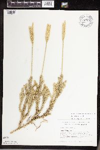 684852[1339897]Meyer, Rob 401977-08-08 United States, Minnesota, Cook, Superior National Forest. Cook Co. Superior National Forest. 4.0 mi S of Trails End National Forest campground along Gunflint Trail; W side of Gun Cook Co. Superior National Forest. 4.0 mi S of Trails End National Forest campground along Gunflint Trail; W side of Gunflint Trail; NE1/4 NE1/4 sec.8 T65N R4W.. 065N 04W 8, 48.127957 -90.868849 |
MIN:Plants | 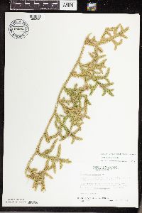 686864[1339882]Wheeler, Gerald 12901977-05-15 United States, Minnesota, Itasca, Itasca Co. Coll. Site #6. NW1/4 SW1/4 Sec.32 T55N R26W, approx. 6 mi SW of Grand Rapids.;;055N;26W;32, 47.201795 -93.678693 |
MIN:Plants | 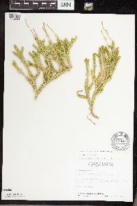 687136[1339883]Wheeler, Gerald 1563-a1977-06-04 United States, Minnesota, Itasca, Itasca Co. Coll. Site #39. SE1/4 SE1/4 Sec.29 T57N R25W, approx. 10 mi N of Grand Rapids.;;057N;25W;29, 47.381921 -93.530214 |
MIN:Plants | 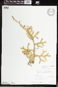 691353[1339832]Clemants, Steven 7151977-06-18 United States, Minnesota, Clearwater, Clearwater Co. 1.5 mi N of Itasca Post Office; T144N R36W SE1/4 Sec. 22.;Itasca State Park;144N;36W;22, 47.275091 -95.222472 |
MIN:Plants | 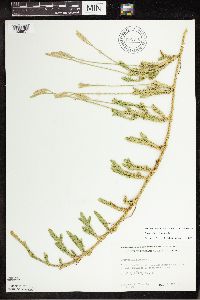 691376[1339951]Clemants, Steven 7361977-06-28 United States, Minnesota, Beltrami, 8.85 mi N of Tamarack River on Rt.72. ;Beltrami Island State Forest / Red Lake Wildlife Management Area;156N;31W;36, 48.287425 -94.564987 |
MIN:Plants | 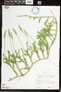 691411[1339884]Ownbey, Gerald 60581978-07-11 United States, Minnesota, Cass, Chippewa National Forest / Leech Lake Indian Reservation. Cass Co. Bowstring Twp, T144N, R29W, Sec.13, SW1/4. W side of U.S. Forest Service Rd.#2131, 2.4 mi S of its jnc. with U Cass Co. Bowstring Twp, T144N, R29W, Sec.13, SW1/4. W side of U.S. Forest Service Rd.#2131, 2.4 mi S of its jnc. with U.S.F.S. Rd.#3762.. 144N 29W 13, 47.285386 -94.301761 |
MIN:Plants | 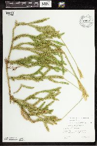 694801[1339960]Wagner, W. 731831973-08-09 United States, Minnesota, Beltrami, Beltrami Co.: 1 mi W of junc. Rte.1 & Blackduck Rd, T1512N, R33W, sect.26.;Red Lake Indian Reservation;151N;33W;26, 47.867478 -94.840165 |
MIN:Plants | 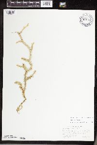 694805[1339887]Wagner, W. 756351975-08-20 United States, Minnesota, Cass, Cass Co.: Ottertail Peninsula, Leech Lake, 0.3 mi E of W. Junction of 2132 with crossroad from 2132 to Two Points Rd.;Chippewa National Forest / Leech Lake Indian Reservation;N;;, 47.221477 -94.412916 |
MIN:Plants | 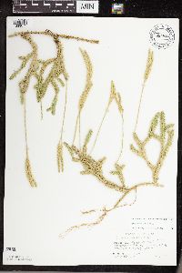 694826[1339873]Wagner, W. 755071975-08-00 United States, Minnesota, Itasca, Itasca Co.: Morph Meadow Wildlife Management Area, R29W, T147N, Sec.22;Chippewa National Forest / Leech Lake Indian Reservation;147N;29W;22, 47.53684 -94.339016 |
MIN:Plants | 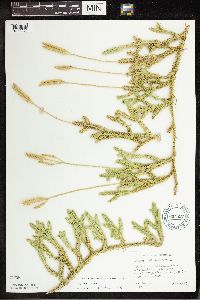 694827[1339964]Wagner, W. 731531973-08-03 United States, Minnesota, Beltrami, Beltrami Co.; Red Lakes Area, Indian Service Rd.18, 0.4 mi of Minn. Rt.1, R33W, T151N, sec.25;Red Lake Indian Reservation;151N;33W;25, 47.868166 -94.818547 |
MIN:Plants | 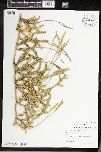 694860[1339904]Wagner, W. 731071973-07-27 United States, Minnesota, Clearwater, Clearwater Co.: Anchor-Matson Rd, T143N, R37W, Sec.24.;White Earth Indian Reservation;143N;37W;24, 47.187731 -95.307688 |
MIN:Plants | 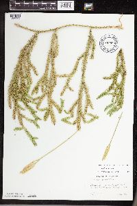 694883[1339905]Wagner, W. 731821973-08-09 United States, Minnesota, Beltrami, Beltrami Co.; 1 mi W of jnc. Rt.1 and Blackduck Rd, Sec. 26, T151N, R33W.;;151N;33W;26, 47.867478 -94.840165 |
MIN:Plants |  699131[1339934]Sather, Nancy 1491977-06-29 United States, Minnesota, Saint Louis, St. Louis Co. NE1/4, SE1/4, S15 and W1/2, NW1/4, SW1/4, S14, T60N, R12W;Superior National Forest;T060N R12W S14, 47.679999 -91.84956 |
MIN:Plants |  699132[1339950]Sather, Nancy 111976-05-13 United States, Minnesota, Saint Louis, St. Louis Co. Phenology plot 8. SE1/4, S2, T59N, R12W;Superior National Forest;059N;12W;02, 47.622439 -91.824615 |
MIN:Plants |  699133[1339915]Sather, Nancy 1791976-07-07 United States, Minnesota, Lake, Lake Co. USFS road #112 W of hwy.2; plot #10, S1, T59N, R11W;Superior National Forest;059N;11W;01, 47.625115 -91.665222 |
MIN:Plants |  717227[1339947]Peck, J. 80-8571980-08-20 United States, Minnesota, Winona, Winona Co.: John Latsch park.;John Latch State Park;N;;, 44.007211 -91.682929 |
MIN:Plants |  717936[1339949]Johnson, Gary s.n.1978-05-07 United States, Minnesota, Kanabec, Kanabec Co.: 2 mi E of jnc. of hwy 27 and 47, N1/2 of Sec. 20, Hay Brook Twp.;;T042N R24W S20, 46.108821 -93.399469 |
MIN:Plants |  722620[1339963]Lustig, K. 9411979-08-20 United States, Minnesota, Anoka, 18 miles southeast of Cambridge;Boot Lake Scientific Natural Area;033N;22W;, 45.336595 -93.126045 |
MIN:Plants |  724694[1339845]Smith, Welby 25101980-06-14 United States, Minnesota, Lake, Lake County...T56N R11W, SW1/4 NE1/4 sec.24.;Superior National Forest;056N;11W;24, 47.32143 -91.675187 |
MIN:Plants |  724870[1311309]Smith, Welby 30501980-07-28 United States, Minnesota, Saint Louis, St. Louis County...T62N R13W, NW1/4 SW1/4 SW1/4 sec.28. About 1/4 mi SE of Purvis Lake.;Purvis Lake-Ober Foundation Scientific Natural Area;062N;13W;28, 47.823966 -91.996687 |
MIN:Plants |  727240[1311313]Smith, Welby 24631980-06-12 United States, Minnesota, Saint Louis, St. Louis Co. T51N R18W, NW1/4 SW1/4 sec.4. On the N side of Co.Rd.8, about 13 mi due E of Floodwood.;;051N;18W;4, 46.92911 -92.919648 |
MIN:Plants |  730025[1339875]Phelps, V. 201980-06-20 United States, Minnesota, Pine, Pine Co. Kettle River Natural Area: 5.5 mi E of Hinckley. SW1/4, NW1/4, Sec.15, T41N, R20W;Kettle River Scientific Natural Area / Sandstone National Wildlife Refuge;041N;20W;15, 46.026704 -92.861009 |
MIN:Plants |  770202[1339967]Smith, Welby 85201983-08-01 United States, Minnesota, Carlton, Carlton Co. Hemlock Ravine State Scientific and Natural Area, about 2.5 mi S of Esko; NW1/4 SE1/4 sec.3, T48N R16W;Hemlock Ravine Scientific Natural Area;048N;16W;3, 46.668678 -92.351353 |
MIN:Plants |  773669[1339942]Boe, J. 14471979-08-12 United States, Minnesota, Lake of the Woods, Lake of the Woods Co. Northwest Angle, near Forestry cabin; Sec.14 R35W T167N;Northwest Angle;167N;35W;14, 49.287271 -95.125557 |
MIN:Plants |  773903[1339941]Boe, J. 7871979-07-15 United States, Minnesota, Lake of the Woods, Lake of the Woods Co. Angle Inlet; N1/2 Sec.31 R34W T168N;Northwest Angle;168N;34W;31, 49.346587 -95.047469 |
MIN:Plants |  774964[1339965]Wheeler, Gerald 61421982-07-17 United States, Minnesota, Carlton, Carlton Co. Approx. 1.5 mi E of the jnc. of Rt.23 and the Soo Railroad tracks. T47N R16W Sec.23;;047N;16W;23, 46.540282 -92.332494 |
MIN:Plants |  775089[1339962]Peterson, Betty s.n.1984-11-00 United States, Minnesota, Sherburne, Sherburne Co. Between Big Lake and Elk River, growing on a 2 acre privalte lot at Co.Rt.15 and 224th St.;;N;;, 45.384459 -93.833304 |
MIN:Plants |  792834[1339878]Johnson, Gary s.n.1986-07-29 United States, Minnesota, Beltrami, SE1/4 Sec. 28. Summit [Twp.], Beltrami Co.;;149N;30W;28, 47.72847 -94.526026 |
MIN:Plants |  792835[1339890]Johnson, Gary s.n.1986-08-07 United States, Minnesota, Kanabec, SE1/4 S.19 and NE1/4 S.30 T42N R23W Kanabec Co.;;T042N R23W S30, 46.101114 -93.294426 |
MIN:Plants |  792836[1339888]Johnson, Gary s.n.1987-08-09 United States, Minnesota, Kanabec, SE1/4 S.27 Hillman [Twp.], Kanabec Co.;;T041N R24W S27, 46.002998 -93.360459 |
MIN:Plants |  792837[1339889]Johnson, Gary s.n.1987-08-09 United States, Minnesota, Kanabec, NW1/4 S.20 T42N R24W Kanabec Co.;;T042N R24W S20, 46.108821 -93.399469 |
MIN:Plants |  818207[1311304]Engels, A. s.n.1991-07-29 United States, Minnesota, Aitkin, Aitkin Co, T51N R26W Sec. 23 NE1/4 NE1/4. Ca. 1 mi E of gen. hwy. 169 & co. rd. 7 on dirt road paralleling Willow River;Hill River State Forest;051N;26W;23, 46.897588 -93.595646 |
MIN:Plants |  818211[1311312]Engels, A. s.n.1991-07-29 United States, Minnesota, Aitkin, Aitkin Co, T51N R26W S23 NW1/4 NW1/4, ca. 0.5 mi E of gen. hwy. 169 and co. rd. 7 on dirt road paralleling Willow River;Hill River State Forest;051N;26W;23, 46.897588 -93.595646 |
MIN:Plants |  821141[1311306]Vixie, D. 4531979-07-26 United States, Minnesota, Saint Louis, Moss Lake (formerly Mud Lake), Ely; Morse Twp. T62N R12W S4 SE1/4. Elevation 1450 ft.;;062N;12W;4, 47.882157 -91.873168 |
MIN:Plants |  828646[1339901]Gordon, William E. 40-531940-07-01 United States, Minnesota, Clearwater, Clearwater Co, Itasca State Park, west of Lake Itasca near north boundary.;Itasca State Park;144N;36W;, 47.197458 -95.201964 |
MIN:Plants |  829559[1311311]Boe, J. 920609071992-06-09 United States, Minnesota, Roseau, Roseau Co. Beltrami Island State Forest; NE1/4 SE1/4 Sec.34 T161N R35W.;Beltrami Island State Forest;161N;35W;34, 48.720177 -95.144524 |
MIN:Plants | 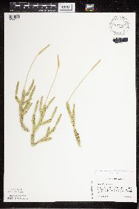 831353[1311334]Engels, A. s.n.1992-06-25 United States, Minnesota, Aitkin, Hill River State Forest. Aitkin Co. Moose-Willow River Wildlife Management Area [this locale actually just outside WMA], Willow River Rd. about 1 mi east of Hwy.169. T51N R26W, NE1/4 NW1/4 Sec.12.. 051N 26W 12, 46.926154 -93.585474 |
MIN:Plants | 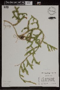 839295[1311307]Cholewa, A.F. 22821995-06-23 United States, Minnesota, Aitkin, Savanna Portage State Park. Aitkin Co. Savanna Portage State Park, about 17 mi NE of McGregor, N of old homesite on W end of Wolf Lake, T50N R22W S6 Aitkin Co. Savanna Portage State Park, about 17 mi NE of McGregor, N of old homesite on W end of Wolf Lake, T50N R22W S6 NE1/4.. 050N 22W 6, 46.850494 -93.192696 |
MIN:Plants | 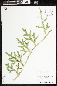 438345[1339973]Whitfeld, T.J.S. 6322005-07-21 United States, Minnesota, Clearwater, Clearwater County...1/4 east [sic] of Waldee Trail; 3/4 west [sic] of Hwy 39...T143N R37W NESW5;White Earth Indian Reservation;143N;37W;05, 47.225851 -95.395675 |
MIN:Plants | 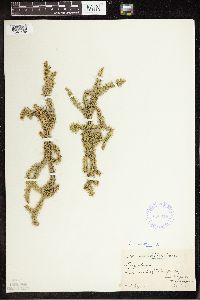 358314[1341459]Cooper, William 1941910-08-13 United States, Michigan, Keweenaw, Tobin's Harbor, Isle Royale;Isle Royale National Park;;;, 48.010955 -88.828422 |
Google Map
Google Maps is a web mapping service provided by Google that features a map that users can pan (by dragging the mouse) and zoom (by using the mouse wheel). Collection points are displayed as colored markers that when clicked on, displays the full information for that collection. When multiple species are queried (separated by semi-colons), different colored markers denote each individual species.