University of Minnesota
http://www.umn.edu/
612-625-5000
http://www.umn.edu/
612-625-5000
Minnesota Biodiversity Atlas
Bell Museum
Dataset: MIN-Plants
Taxa: Lycopodiaceae
Search Criteria: excluding cultivated/captive occurrences
Bell Museum plants | |
 MIN:Plants | 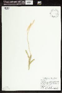 431715[1339966]Dahle, Rolf M. 020462002-10-09 United States, Minnesota, Itasca, Itasca County...About two miles northeast of the town of Swan River. On the east side of Hwy 65, about half way between the highway and a small bog lake...T 53 R 22 NW1/4 of NE!/4 of Sec 6. 053N 22W 6, 47.106945 -93.1711121 |
MIN:Plants | 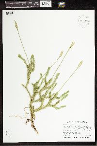 907243[1339971]Smith, Welby 309632008-07-02 United States, Minnesota, Saint Louis, St. Louis County ... About 18 miles E-SE of Gilbert, in Superior National Forest ... T57N R14W SW1/4 of SW1/4 of Sec 34;Superior National Forest;057N;14W;34, 47.3744444 -92.1072222 |
MIN:Plants | 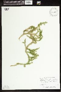 455758[1339927]Carlson, Bruce 006961998-06-30 United States, Minnesota, Crow Wing, Crow Wing Co.; Collected 0.5 miles north of Erskine Lake and 1.1 miles ESE of Pine Center. DNR Releve 7623; T43N R28W NWNW16. 043N 28W 16, 46.212571 -93.890839 |
MIN:Plants | 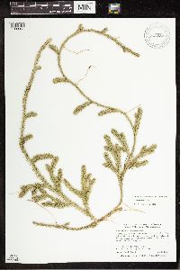 907082[1339957]Smith, Welby 284192000-05-05 United States, Minnesota, Pennington, Oriniak Wildlife Management Area. Pennington County...Oriniak State Wildlife Management Area about 12 miles SE of Thief River Falls...T 152N R 41W SE1/4 of SE1/4 of Sec 18. 152N 41W 18, 47.9797222 -95.9466667 |
MIN:Plants | 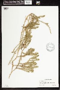 904767[1341457]Lawrence, Donald s.n.1953-08-20 United States, Alaska, Tlingit Point area.;Glacier Bay National Park;;;, 58.797845 -136.458473 |
MIN:Plants | 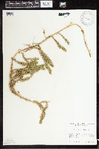 520322[1341518]Lawrence, Donald s.n.1952-08-20 United States, Alaska, Tlingit Point area.;Glacier Bay National Park;;;, 58.7577778 -136.18 |
MIN:Plants | 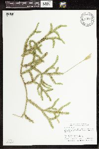 915075[1339970]Smith, Welby 314232009-08-29 United States, Minnesota, Cook, Boundary Waters Canoe Area Wilderness / Superior National Forest. Cook County...Boundary Waters Canoe Area Wilderness, Superior National Forest. On the north side of Winchell Lake... T64N R2W NW1/4 of SE1/4 of Sec 30. 064N 02W 30, 47.9941667 -90.6247222 |
MIN:Plants | 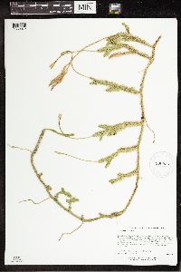 900936[1339972]Lee, Michael MDL39412005-06-09 United States, Minnesota, Becker, Two Inlets State Forest. Becker County...Two Inlets State Forest...on the north side of One Acre Lake, four miles south of Two Inlets...T141N R36W NE1/4 of SE1/4 of SW1/4 Sec. 26. 141N 36W 26, 46.995488 -95.203537 |
MIN:Plants | 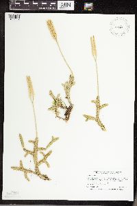 492623[1339857]Smith, Welby 258451995-08-14 United States, Minnesota, Cook, Boundary Waters Canoe Area Wilderness / Superior National Forest. Cook County ... In the Boundary Waters Canoe Area Wilderness, Superior National Forest ... southwest end of Zenith Lake ... T 63N R 5W NE1/4 of NE1/4 of Sec 14. 063N 05W 14, 47.9438896 -90.9169464 |
MIN:Plants | 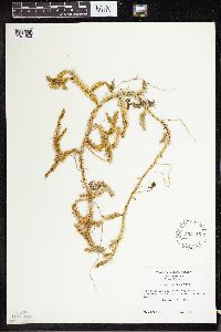 553145[1341502]Porter, C.L. 77221958-09-09 United States, Washington, Jefferson, Washington. Olympic Peninsula ... Jefferson County. Near Ruby Beach.;Olympic National Park;;;, 47.710912 -124.415477 |
MIN:Plants | 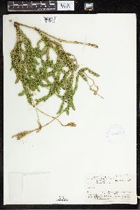 421699[1341503]Ahlgren, Clifford 8991950-08-10 Canada, Ontario, Rainy River, 1/8 mile south of Moose Bay, Quetico Park;;;;, 47.708531 -81.84899 |
MIN:Plants | 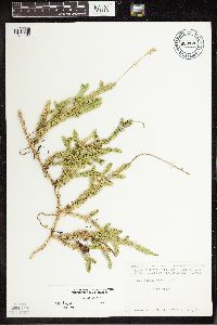 680176[1341462]Coffin, Barbara 4071976-07-02 United States, Wisconsin, Ashland, Presque Isle Point, Stockton Island, Apostle Islands National Lakeshore;Apostle Islands National Lakeshore;;;, 46.963491 -90.660423 |
MIN:Plants |  923083[1339933]Smith, Welby 204221992-06-16 United States, Minnesota, Cass, About one mile south of Lake Thirteen in Chippewa National Forest...T 144N R 31W NW1/4 of SW1/4 of Sec 24;Chippewa National Forest / Leech Lake Indian Reservation;144N;31W;24, 47.2694444 -94.5519444 |
MIN:Plants |  930115[1339848]Smith, Welby 161031989-08-13 United States, Minnesota, Cook, SE end of Ranger Lake. NW1/4 of SE1/4 of section;Boundary Waters Canoe Area Wilderness / Superior National Forest;063N;04W;03, 47.969101 -90.817411 |
MIN:Plants |  935357[1339851]Smith, Welby R. 333152011-08-10 United States, Minnesota, Lake, Boga Lake, off the west end of Lake Isabella. SW of NE of section;Boundary Waters Canoe Area Wilderness / Superior National Forest;062N;07W;32, 47.80995 -91.2363667 |
MIN:Plants |  937005[1339936]Smith, Welby R. 302882007-07-12 United States, Minnesota, Beltrami, About 17 miles north of Four Town. NE of NW of section;;158N;36W;05, 48.537376 -95.3122395 |
MIN:Plants | 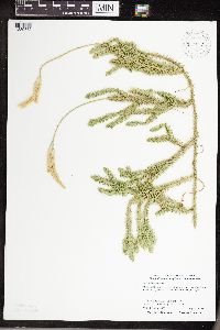 222153[1339852]Smith, Welby R. 306792007-08-23 United States, Minnesota, Koochiching, At the north end of Moose Lake. SE of SE of section;;068N;24W;09, 48.3915724 -93.4245327 |
MIN:Plants | 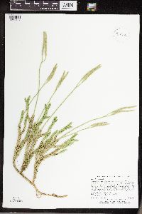 932260[1339849]Lee, Michael MDL47422008-07-30 United States, Minnesota, Hubbard, Along the lower reaches of the Schoolcraft River south of Lake Plantagenet, eight miles south-southwest of Bemidji. East of the river. E1/2 of NE1/4 of NE1/4 of section;;145N;34W;25, 47.3514845 -94.9270457 |
MIN:Plants | 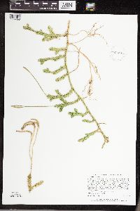 932281[1339850]Lee, Michael MDL46442008-06-26 United States, Minnesota, Cass, South of Boy Lake, six miles south-southwest of the town of Boy River, seven miles north-northeast of Longville. SE1/4 of NW1/4 of NW1/4 of section;;142N;27W;31, 47.0791584 -94.1550481 |
MIN:Plants |  939664[1339968]Smith, Welby R. 321562010-08-29 United States, Minnesota, Cook, About 13 miles northwest of Lutsen. SE of NW of section;;062N;04W;33, 47.8126358 -90.8463763 |
MIN:Plants | 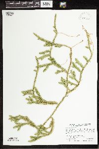 939897[1339921]Smith, Welby R. 307662007-09-05 United States, Minnesota, Saint Louis, About 12 miles N-NW of Virginia. NW of SW of section;;060N;18W;16, 47.680828 -92.6434913 |
MIN:Plants | 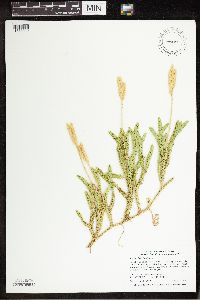 730280[1339919]Smith, Welby R. 320902010-08-28 United States, Minnesota, Cook, About 8 miles N-NW of Hovland. NE of SW of section;Grand Portage State Forest;063N;03E;11, 47.9530556 -90.0327778 |
MIN:Plants | 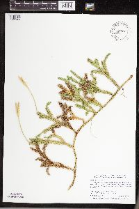 438722[1339900]Smith, Welby R. 307122007-08-24 United States, Minnesota, Koochiching, About 10 miles east of Big Falls. SE of SW of section;Koochiching State Forest;066N;25W;20, 48.1880556 -93.5869444 |
MIN:Plants | 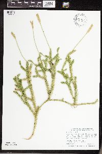 939938[1339853]Smith, Welby R. 307232007-08-24 United States, Minnesota, Koochiching, Along Hwy 65. NE of SW of section;Nett Lake Indian Reservation;065N;23W;16, 48.1163889 -93.3066667 |
MIN:Plants | 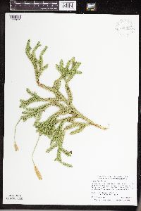 939926[1339899]Smith, Welby R. 307352007-08-24 United States, Minnesota, Itasca, About 13 miles south of Togo. SW of SW of section;George Washington State Forest;060N;22W;31, 47.6342267 -93.1910205 |
MIN:Plants |  939885[1339928]Smith, Welby R. 307782007-09-05 United States, Minnesota, Saint Louis, About 7 miles northwest of Cook. SE of SW of section;;063N;19W;19, 47.9235943 -92.8217 |
MIN:Plants |  939869[1339920]Smith, Welby R. 307942007-09-06 United States, Minnesota, Saint Louis, About 6 miles southeast of Hibbing. NW of SW of section;;056N;19W;06, 47.3623126 -92.5515897 |
MIN:Plants |  942029[1339894]Smith, Welby R. 319972010-08-05 United States, Minnesota, Cook, On the north side of Dugout Lake. NE of NE of section;Boundary Waters Canoe Area Wilderness / Superior National Forest;063N;01W;18, 47.9441251 -90.4934287 |
MIN:Plants |  948197[1292412]Smith, Welby R. WRS308042007-09-06 United States, Minnesota, Saint Louis, About 6 miles southeast of Hibbing.; T056N R19W sec06, 47.3623126 -92.5515897 |
MIN:Plants |  947892[1292027]Smith, Welby R. 305132007-08-02 United States, Minnesota, Aitkin, Hill River State Forest, about 6 miles east of Hill City. SW of SE of section; T052N R25W sec14, 46.9892306 -93.4724094 |
MIN:Plants |  947968[1291974]Smith, Welby R. 305952007-08-16 United States, Minnesota, Carlton, In Fond Du Lac State forest, about 5 miles northeast of Cromwell. NW of SW of section; T049N R20W sec13, 46.7271603 -92.8260808 |
MIN:Plants |  952112[1297210]Smith, Welby R. 349782014-06-24 United States, Minnesota, Saint Louis |
MIN:Plants |  953020[1297627]Smith, Welby R. 31028 United States, Minnesota, Lake |
MIN:Plants | 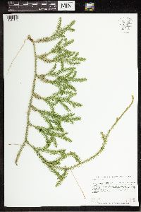 959882[1318179]Anderson, Chel E. 24422017-08-02 United States, Minnesota, Koochiching, ~17 mi SW from Big Falls on Hwy 71; ~2 mi W on Koochiching Cty NFR90; ~500 meters NE into swamp forest., 48.03 -94.09 |
MIN:Plants | 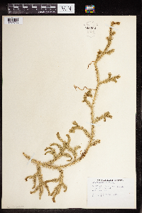 960262[1318733]Eyerdam, Walter 53821948-08-10 United States, Alaska, Washington Bay, Kuiu Island |
MIN:Plants | 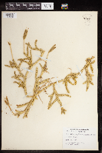 960261[1318734]Eyerdam, Walter 70701948-08-15 United States, Alaska, Port San Juan, Evans Island |
MIN:Plants | 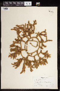 960260[1318735] 91900-00-00 United States, New Hampshire |
MIN:Plants |  960258[1318737] 1888-00-00 United States, Maine |
MIN:Plants |  960496[1318976]Stork, H.E. 1925-00-00 United States, Minnesota, Itasca |
MIN:Plants |  960467[1329005] 1925-00-00 United States, Minnesota, Itasca |
MIN:Plants |  963130[1346801]Whitfeld, T.J.S. 24692019-06-22 United States, Minnesota, Cass, US Army Corps of Engineers Winnibigoshish Recreation Area, triangle; 47.422547 -94.053783, 47.422547 -94.053783 |
MIN:Plants |  968005[1368565]T. J. S. Whitfeld 21672019-06-17 United States, Minnesota, Lake, Boundary Waters Canoe Area Wilderness, northeast part of Alice Lake, 47.947108 -91.208844, 472m |
MIN:Plants |  557379[1341451]Moir, D.R. 1957-07-10 Canada, Ontario, vicinity of Sandy Lake, Sandborn Bay, 52.980283 -93.387657 |
MIN:Plants |  557380[1341453]Moir, D.R. 1957-07-10 Canada, Ontario, vicinity of Sandy Lake, Sandborn Bay, 52.980283 -93.387657 |
MIN:Plants |  557370[1341454]Moir, D.R. 1957-07-07 Canada, Ontario, Vicinity of Sandy Lake, 53.033333 -92.916667 |
MIN:Plants |  557159[1341455]Moir, D.R. 1957-07-27 Canada, Ontario, Sandy Lake. W side of S Bay, E end of lake |
MIN:Plants |  556352[1341456]Moir, D.R. 1953-07-01 Canada, Ontario, Vicinity of Pickle Lake, 48.943056 -85.5775 |
MIN:Plants |  522835[1341463]W.S. Cooper 1907-08-18 United States, Maine, Mt. Katahdin, 45.904284 -68.921356, 610m |
MIN:Plants |  55150[1341464]Topping, D.L. 1895-09-24 United States, New York, Chenango, Bainbridge, 42.293413 -75.479348 |
MIN:Plants |  503950[1341465]Russell, N.H. 1954-08-08 United States, New York, Albany, E.N. Huyck Preserve. Rensselaerville, 42.515161 -74.134253 |
MIN:Plants |  486871[1341466]Churchill, J.R. 1908-07-20 Canada, New Brunswick, Connors. St. John River, 47.2 -68.833333 |
MIN:Plants |  423098[1341467]R.T. Ward 1949-07-31 United States, Alaska, Juneau Ice Field; Camp 12 ridge, 58.301944 -134.419722, 762m |
MIN:Plants |  55165[1341468] United States, New York, 43 -75 |
MIN:Plants | 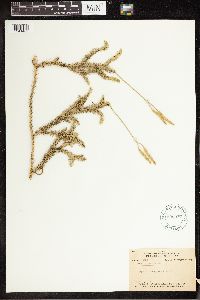 598076[1341469]Gates, Frank C. 1925-07-31 United States, Michigan, Emmet, vicinity of the University of Michigan Biological Station, 45.560011 -84.677821 |
MIN:Plants | 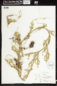 622508[1341470]Rolland-Germain 1965-06-21 Canada, Quebec, Terrebonne, Saint-Hippolyte, 45.521984 -73.68348 |
MIN:Plants | 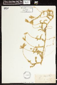 516435[1341471]Howell 1895-08-00 United States, Alaska, Yes Bay, 55.913333 -131.793611 |
MIN:Plants | 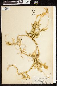 55168[1341472]C.V. Piper 1890-07-20 United States, Washington, Union City, 47.35 -123.0833 |
MIN:Plants | 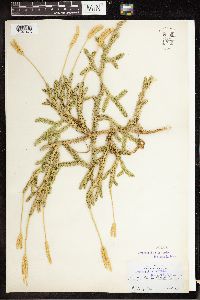 55151[1341473]Carlton C. Curtis 1894-07-15 United States, Maine, Portland, 43.661471 -70.255326 |
MIN:Plants | 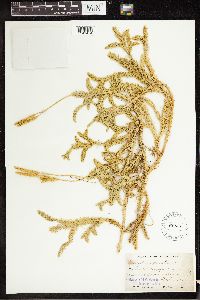 55157[1341474]M.W. Gorman 1894-09-02 United States, Alaska, Shores of Bshur Canal[?]; 64.969324 -153.540365, 64.969324 -153.540365 |
MIN:Plants | 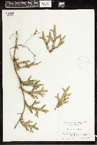 415904[1341475]Stanley L. Glowenke 1946-05-29 United States, Pennsylvania, Lackawanna, Lackawana Mts. 1.5 mi NW of Jermyn, 41.546282 -75.565994 |
MIN:Plants | 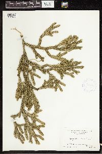 415903[1341476]Stanley L. Glowenke 1946-05-25 United States, Pennsylvania, Hollisters, along Roaring Brook, 41.24036 -76.102427 |
MIN:Plants |  486923[1341477]Walter Deane 1889-08-07 United States, New Hampshire, E of Jaffrey, 42.813973 -72.023136 |
MIN:Plants |  521798[1341478]S & B 1907-09-12 United States, Maryland, Garrett, Thayerville |
MIN:Plants |  398150[1341479]Harper, Francis 1947-06-27 Canada, Keewatin, NW extremity of Nueltin Lake, Windy River 1 mile above mouth, 60.444616 -99.563171 |
MIN:Plants |  600438[1341480]Radford, A.E. 1966-10-08 United States, North Carolina, Haywood, Beech Gap, W Fork of Pigeon River, 35.525185 -82.840555 |
MIN:Plants | 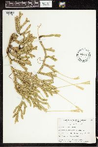 449751[1341481]Garton, C.E. 1950-08-17 Canada, Ontario, Thunder Bay, S end of Trout Lake, Gorham Twp., 46.317691 -79.338149 |
MIN:Plants | 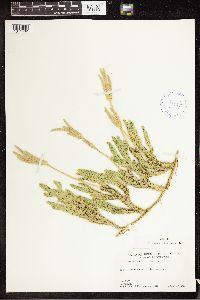 414477[1341482]M.O. Malte 1927-07-15 Canada, New Brunswick, St. Leonard, 47.163316 -67.924614 |
MIN:Plants | 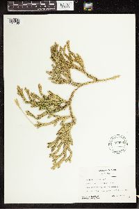 559506[1341483]J.H. Soper 1950-07-12 Canada, Ontario, Muskoka, Camp Billie Bear near Huntsville, 45.333333 -79.216667 |
MIN:Plants | 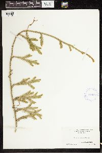 415106[1341484]R.T. Whittenberger 1942-06-17 United States, Pennsylvania, Sullivan, 1.25 mi W of Eagles Mere, 41.410909 -76.606045 |
MIN:Plants | 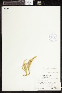 415404[1341485]R.T. Ward 1949-09-07 United States, Alaska, Juneau Ice Field; Camp 4 ridge, 58.65455 -134.296387, 1311m |
MIN:Plants | 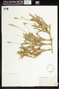 55153[1341486]Topping, D.L. 1895-10-02 United States, New York, Delaware, Harpersfield, 42.438412 -74.687375 |
MIN:Plants | 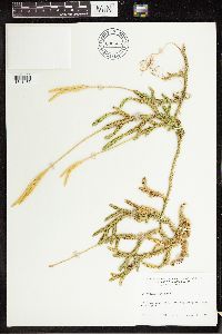 690405[1341487]H.E. Ahles 1977-08-29 United States, Massachusetts, Hampshire, along Massachusetts Road 9 in Goshen |
MIN:Plants | 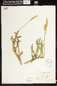 565470[1341488]Hans Wilkens 1939-08-13 United States, Pennsylvania, Sullivan, W of Laporte |
MIN:Plants |  55155[1341489] 1890-08-22 Canada, Newfoundland and Labrador, Trinity Bay, 48.978611 -53.792222 |
MIN:Plants |  423587[1341490]R.M. and A.F. Tryon 1947-08-31 Canada, Ontario, Thunder Bay, Thunder Cape; 1 mile NW of Silver Islet, 48.343566 -88.832061 |
MIN:Plants |  425021[1341491]Marie-Victorin 1940-08-18 Canada, Quebec, Gaspe, Claude River |
MIN:Plants |  388058[1341492]Eaton, A.A. 1896-00-00 United States, New Hampshire, Kensington, 42.927033 -70.943945 |
MIN:Plants |  402842[1341493]L.H. Sinners 1940-08-26 United States, Wisconsin, Bayfield, Sand Bay |
MIN:Plants |  55159[1341494]L.F. Clarke 1899-08-11 Canada, Ontario, Sudbury, 46.5 -80.966667 |
MIN:Plants |  55166[1341495]Fisher, G.L. 1899-08-22 Canada, Ontario, Wahnapitae, 46.75 -80.75 |
MIN:Plants |  55163[1341496]Rosendahl, C.O. 1902-07-00 Canada, British Columbia, Vancouver Island, Renfrew |
MIN:Plants | 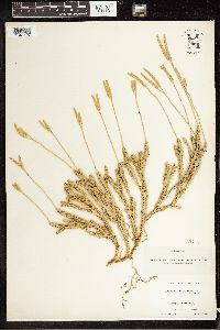 55169[1341497]Fernald, M.L. 1893-07-10 United States, Maine, Aroostook, Mouth of the Aroostook River, Fort Fairfield, 46.432848 -68.465847 |
MIN:Plants | 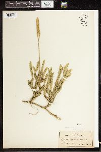 55154[1341498]John W. Harshberger 1904-07-13 United States, Pennsylvania, Pocono Plateau, 41.247532 -75.30032 |
MIN:Plants | 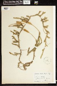 55147[1341499]K.M. Wiegand 1914-09-06 United States, New York, Cayuga, Summer Hill. Lake Como to Homer, 42.6333 -76.3167 |
MIN:Plants | 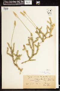 55156[1341500]Fisher, G.L. 1898-08-08 Canada, Ontario, Baysville, 45.148889 -79.114722 |
MIN:Plants |  333769[1341501]Rodney H. True 1926-08-16 United States, New Hampshire, Coos, Mt. Evans, Gorham, 44.3833 -71.1167 |
MIN:Plants |  929789[1341504]Mark J. Leoschke 1999-09-04 United States, Iowa, Monroe, Union Twp. T73N R18W S20, 41.110361 -92.955813 |
MIN:Plants |  425020[1341505]F.F. Lucien 1939-07-19 Canada, Quebec, Labelle, Bellerive |
MIN:Plants |  385147[1341506]R.M. Tryon Jr. 1941-07-15 United States, Michigan, Mountain Lake, 43.63977 -86.026731 |
MIN:Plants |  303926[1341507]T.G. Yuncker 1929-08-20 Canada, Ontario, Near Spanish River, 46.166667 -82.333333 |
MIN:Plants |  415670[1341508]W.F. Westerfeld United States, Pennsylvania, Clearfield, Girard Twp, 42.000334 -80.318119 |
MIN:Plants |  589255[1341509] United States, New York, Sullivan, Catskill Mountains. W slope of W branch of Mongaup River, about 1.5 mi N of Mongaup Valley and 5 mi WNW of Monticello, 41.446548 -74.761833 |
MIN:Plants |  291625[1341510]J.M. Grant 1923-05-00 United States, Washington, Marysville |
MIN:Plants |  449690[1341511]Garton, C.E. 1950-08-20 Canada, Ontario, Thunder Bay, 1 mile W of Perry's Bay on T-Harbour Trail, Silver Islet, Sibley, 45.517008 -79.317775 |
MIN:Plants |  528489[1341512]Garton, C.E. 1951-07-24 Canada, Ontario, Thunder Bay, NE corner of Roundtable Lake, Hardwick Twp., 48.214368 -90.156385 |
MIN:Plants |  594825[1341513]W.K.W. Baldwin 1961-06-30 Canada, Ontario, Ignace, 1 mi NE at fire tower, 49.416667 -91.666667 |
MIN:Plants |  388062[1341514]H.G. Washburn 1942-11-20 United States, Wisconsin, Price, 5 mi W of Flambeau Reservation. NE of Park Falls, 45.973735 -90.364371 |
MIN:Plants |  388060[1341515]Wadmond, S.C. 1927-09-17 United States, Wisconsin, Walworth, Edge of Larix swamp, East Troy. Section 3, 42.835837 -88.355116 |
MIN:Plants |  508184[1341516] United States, Washington |
MIN:Plants |  599565[1341517] United States, Alaska |
Google Map
Google Maps is a web mapping service provided by Google that features a map that users can pan (by dragging the mouse) and zoom (by using the mouse wheel). Collection points are displayed as colored markers that when clicked on, displays the full information for that collection. When multiple species are queried (separated by semi-colons), different colored markers denote each individual species.