University of Minnesota
http://www.umn.edu/
612-625-5000
http://www.umn.edu/
612-625-5000
Minnesota Biodiversity Atlas
Bell Museum
Dataset: MIN-Plants
Taxa: Amphicarpaea
Search Criteria: excluding cultivated/captive occurrences
Bell Museum plants | |
 MIN:Plants | 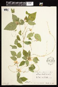 Amphicarpaea bracteata (L.) Fernald 561423[1074590]Ovington, John s.n.1959-08-15 United States, Minnesota, Anoka, Cedar Creek Natural History Area;Cedar Creek National History Area;034N;23W;, 45.41027 -93.198658 |
MIN:Plants | 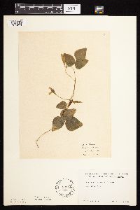 Amphicarpaea bracteata (L.) Fernald 564441[1074574]Rhone, R. s.n.1940-08-23 United States, Minnesota, Itasca, Deer River;;N;;, 47.339548 -93.793367 |
MIN:Plants | 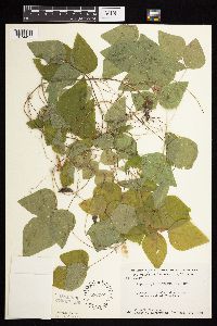 Amphicarpaea bracteata (L.) Fernald 566222[1074497]Moore, John 242401958-09-17 United States, Minnesota, Blue Earth, 3 mi W of Mankato;;N;;, 44.15765 -94.110782 |
MIN:Plants | 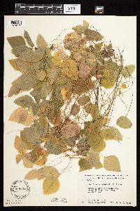 Amphicarpaea bracteata (L.) Fernald 566238[1074573]Moore, John; Heig, V. 240291958-09-09 United States, Minnesota, Kittson, 1/4 mi. N of Hallock;;N;;, 48.787998 -96.944387 |
MIN:Plants | 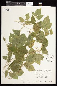 Amphicarpaea bracteata (L.) Fernald 568792[1074543]Moore, John 252681960-08-18 United States, Minnesota, Blue Earth, s shore of Loon Lake;;N;;, 44.091614 -94.178912 |
MIN:Plants | 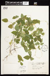 Amphicarpaea bracteata (L.) Fernald 568849[1074604]Moore, John 252141960-08-12 United States, Minnesota, Anoka, S of farmsted S side of Fish Lake.;Cedar Creek National History Area;034N;23W;, 45.392237 -93.168622 |
MIN:Plants | 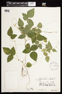 Amphicarpaea bracteata (L.) Fernald 572575[1074494]Moore, John 257041961-08-07 United States, Minnesota, Anoka, NE of the Cornea Cabin, Cedar Creek Natural History Area;Cedar Creek National History Area;034N;23W;, 45.409938 -93.199044 |
MIN:Plants | 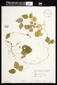 Amphicarpaea bracteata (L.) Fernald 574413[1074592]Moore, John; et al. 248131959-09-17 United States, Minnesota, Kittson, Kittson County...2 mi. S of St. Vincent;;;;, 48.937614 -97.223327 |
MIN:Plants |  Amphicarpaea bracteata (L.) Fernald 574623[1074493]Moore, John 247191959-07-29 United States, Minnesota, Kittson, below dam at Bronson State Park;Lake Bronson State Park;161N;46W;, 48.721982 -96.613159 |
MIN:Plants |  Amphicarpaea bracteata (L.) Fernald 583830[1074541]Gunderson, R. 5411961-08-06 United States, Minnesota, Washington, St. Croix River, 3 mi N of Stillwater;Saint Croix National Riverway;030N;20W;, 45.09983 -92.80583 |
MIN:Plants |  Amphicarpaea bracteata (L.) Fernald 590079[1074602]Meierotto, R. s.n.1963-07-26 United States, Minnesota, Becker, Becker Co. Sec. 5, T142N, R36W.;Itasca State Park;142N;36W;5, 47.1449325 -95.2653681 |
MIN:Plants |  Amphicarpaea bracteata (L.) Fernald 591976[1074601]Moore, John 267751965-08-11 United States, Minnesota, Blue Earth, 3 mi. W of Mankato;;N;;, 44.15765 -94.110782 |
MIN:Plants | 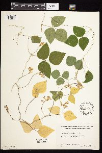 Amphicarpaea bracteata (L.) Fernald 592369[1074492]Westkaemper, Remberta s.n.1964-08-00 United States, Minnesota, Stearns, Stearns County...St. Joseph, St. Benedict's [College] woods;;124N;29W;10, 45.5661717 -94.3116988 |
MIN:Plants | 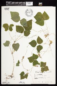 Amphicarpaea bracteata (L.) Fernald 669979[1074430]Grimm, Eric 301974-07-15 United States, Minnesota, Hennepin, Hennepin County...YMCA Camp Ihduhapi, Loretto;;118N;24W;12, 45.04384 -93.65598 |
MIN:Plants | 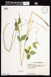 Amphicarpaea bracteata (L.) Fernald 670653[1074435]Heitlinger, M. 6381972-07-23 United States, Minnesota, McLeod, Schaefer Prairie, SE1/4 S34, T115N, R29W; NW corner of tract, near pond;Schaefer Prairie, The Nature Conservancy;115N;29W;34, 44.7250496 -94.3049103 |
MIN:Plants | 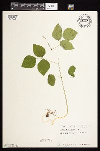 Amphicarpaea bracteata (L.) Fernald 685180[1074581]Stassen, Carol 531977-05-28 United States, Minnesota, Lyon, Camden State Park; T110N, R42W, Sec. 5;Camden State Park;110N;42W;5, 44.3631806 -95.9274434 |
MIN:Plants | 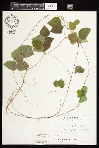 Amphicarpaea bracteata (L.) Fernald 687544[1074597]Wheeler, Gerald; Glaser, Paul 19861977-07-09 United States, Minnesota, Itasca, Site 101. E1/2 NE1/4 Sec. 32, T56N, R25W; ca. 3.5 mi. N of Grand Rapids. Adjacent to Hwy. 38.;;056N;25W;32, 47.2895709 -93.5442015 |
MIN:Plants | 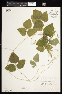 Amphicarpaea bracteata (L.) Fernald 696537[1074455]Smith, Welby 6391978-08-02 United States, Minnesota, Wright, Wright Co. T121N, R26W, NE1/4 Sec. 10. 1/2 mi. NW of the jct. of state aid road 39 and county aid road 111.;Lake Maria State Park;121N;26W;10, 45.3039609 -93.9428922 |
MIN:Plants | 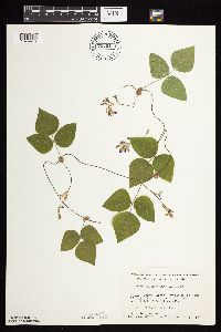 Amphicarpaea bracteata (L.) Fernald 701011[1074475]Dorio, J. 7271977-08-03 United States, Minnesota, Morrison, Ripley Esker, ca. 3 mi. NE of Camp Ripley jct. NE of old field. T42N, R31W, Sec. 19.;Ripley Esker Scientific Natural Area;042N;31W;19, 46.1062834 -94.30299 |
MIN:Plants | 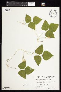 Amphicarpaea bracteata (L.) Fernald 701247[1074469]Dorio, J. 5711977-07-16 United States, Minnesota, Stearns, Stearns Co. Partch Woods, 4.5 mi. NW of St. Joseph, on Co. Rd. 3. T125N, R29W, Sec. 19.;Partch Woods Scientific Natural Area;125N;29W;19, 45.6228979 -94.3771346 |
MIN:Plants | 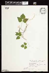 Amphicarpaea bracteata (L.) Fernald 701311[1074470]Dorio, J. 6291977-07-22 United States, Minnesota, Benton, Benton Co. Englund Ecotone, ca. 5 mi. SE of Rice. T37N, R31W, Sec. 13.;Englund Ecotone, The Nature Conservancy;037N;31W;13, 45.6985631 -94.1434524 |
MIN:Plants | 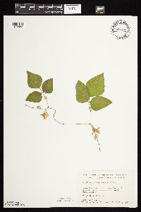 Amphicarpaea bracteata (L.) Fernald 701388[1074468]Dorio, J. 6641977-07-26 United States, Minnesota, Morrison, Lake Alexander, ca. 7 mi. N of Randall on Co. Rd. 6. T131N, R30W, Sec. 6.;;131N;30W;6, 46.1870677 -94.5062348 |
MIN:Plants | 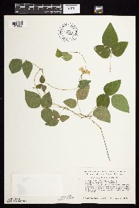 Amphicarpaea bracteata (L.) Fernald 704621[1074456]Smith, Welby 16721979-08-16 United States, Minnesota, Wabasha, T109N, R09W, NE1/4 NE1/4 Sec. 19. 1/6 km due E of Hwy. 61.;;109N;09W;19, 44.2291857 -91.9393697 |
MIN:Plants | 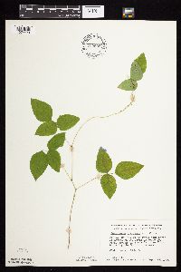 Amphicarpaea bracteata (L.) Fernald 709939[1074429]Wheeler, Gerald 49671979-09-17 United States, Minnesota, Washington, William O'Brien State Park. William O'Brien State Park; just S of Marine on St. Croix on Rte. 95. In the woodland bordering the St. Croix River. T William O'Brien State Park; just S of Marine on St. Croix on Rte. 95. In the woodland bordering the St. Croix River. T32N, R19W, Sec. 31.. 032N 19W 31, 45.2171528 -92.7641397 |
MIN:Plants | 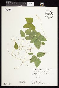 Amphicarpaea bracteata (L.) Fernald 715545[1074496]Farrell, P. 1501979-08-16 United States, Minnesota, Beltrami, Pennington Orchid Bog SNA: 1 mi N of Pennington, NW1/4 S3, T146N, R30W;Leech Lake Indian Reservation / Pennington Bog Scientific Natural Area;146N;30W;3, 47.491615 -94.4690408 |
MIN:Plants | 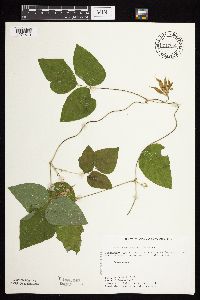 Amphicarpaea bracteata (L.) Fernald 717689[1074610]Farrell, P. 1931979-08-27 United States, Minnesota, Norman, Frenchman's Bluff: 2.5 mi N of Flom, frac. S18, T143N, R43W;Frenchmans Bluff Scientific Natural Area;143N;43W;18, 47.2019677 -96.1838932 |
MIN:Plants | 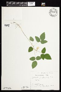 Amphicarpaea bracteata (L.) Fernald 722606[1074463]Lustig, K. 9921979-08-23 United States, Minnesota, Anoka, 18 mi. SE of Cambridge;Boot Lake Scientific Natural Area;033N;22W;, 45.337481 -93.123213 |
MIN:Plants | 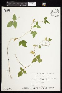 Amphicarpaea bracteata (L.) Fernald 722891[1074465]Lustig, K. 11491979-09-14 United States, Minnesota, Anoka, Anoka Co. Helen Allison Savanna: 14 mi. SE of Cambridge, N1/2 of NE1/4 of Sec. 2, T33N, R23W.;Helen Allison Savanna Scientific Natural Area;033N;23W;2, 45.3777015 -93.1738785 |
MIN:Plants | 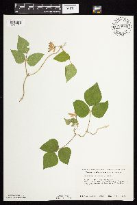 Amphicarpaea bracteata (L.) Fernald 723881[1074464]Smith, Welby 32621980-08-10 United States, Minnesota, Wright, Wright Co. T120N, R23W, NW1/4 NW1/4 Sec. 18. About 2 mi. E of St. Michael. Overlooking the Crow River.;;120N;23W;18, 45.2012961 -93.6354612 |
MIN:Plants | 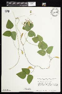 Amphicarpaea bracteata (L.) Fernald 724652[1074462]Smith, Welby 33581980-08-17 United States, Minnesota, Wright, Wright Co. T119N, R25W, NW1/4 NE1/4 Sec. 15. Between Hwy. 55 and Soo Line R.R. tracks, ca. 1/4 mi. NW of the springs wa Wright Co. T119N, R25W, NW1/4 NE1/4 Sec. 15. Between Hwy. 55 and Soo Line R.R. tracks, ca. 1/4 mi. NW of the springs wayside.. 119N 25W 15, 45.1157732 -93.817185 |
MIN:Plants | 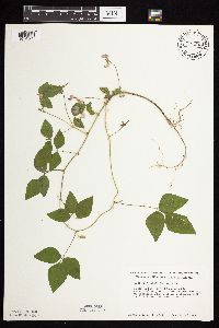 Amphicarpaea bracteata (L.) Fernald 727255[1074563]Smith, Welby 34881980-08-23 United States, Minnesota, Wright, Wright Co. T121N, R23W; SE1/4 NE1/4 Sec. 36. On W bank of the Mississippi River at its confluence with the Crow River j Wright Co. T121N, R23W; SE1/4 NE1/4 Sec. 36. On W bank of the Mississippi River at its confluence with the Crow River just W of Dayton.. 121N 23W 36, 45.24467 -93.5210509 |
MIN:Plants | 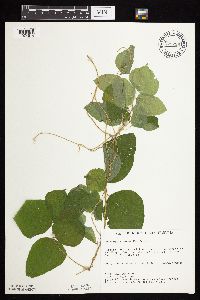 Amphicarpaea bracteata (L.) Fernald 729229[1074514]Berlin, N. 1441979-08-13 United States, Minnesota, Goodhue, Wacouta Pond Natural Area: 5 mi. SE of Red Wing. Portions of Sec. 6, T112N, R13W, and Sec. 31, 32, T113N, R13W.;Wacouta Pond Natural Area, The Nature Conservancy;N;;, 44.5351457 -92.4198697 |
MIN:Plants | 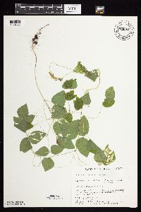 Amphicarpaea bracteata (L.) Fernald 729581[1074565]Converse, C. 5521980-07-30 United States, Minnesota, Pine, 21 mi E of Hinckley. NW1/4 NW1/4 Sec.;Saint Croix State Park;040N;17W;5, 45.98042 -92.49605 |
MIN:Plants | 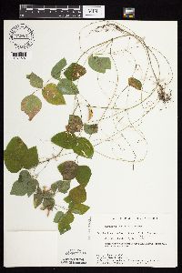 Amphicarpaea bracteata (L.) Fernald 729831[1074607]Converse, C. 6431980-08-29 United States, Minnesota, Pine, Pine Co. Kettle River Natural Area: 5.5 mi E of Hinckley. NE1/4 NE1/4 Sec. 22, T41N, R20W.;Kettle River Scientific Natural Area / Sandstone National Wildlife Refuge;041N;20W;22, 46.0184802 -92.8567103 |
MIN:Plants | 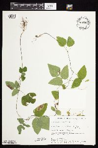 Amphicarpaea bracteata (L.) Fernald 730379[1074564]Phelps, V. 1371980-09-08 United States, Minnesota, Chisago, Chisago Co. Goose Creek Natural Area: 5 mi. SE of Rush City. SW1/4 SE1/4 Sec. 7, T36N, R20W.;Wild River State Park;036N;20W;7, 45.62207 -92.8927646 |
MIN:Plants | 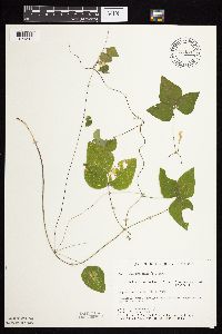 Amphicarpaea bracteata (L.) Fernald 734294[1074513]Cross-Cella, J. 3591980-08-29 United States, Minnesota, Becker, Becker Co. Green Water Lake Natural Area: 5 mi. W of Ponsford. NW1/4 SW1/4 Sec. 34, T141N, R38W.;Greenwater Lake Scientific Natural Area / White Earth Indian Reservation;141N;38W;34, 46.9838935 -95.4976994 |
MIN:Plants | 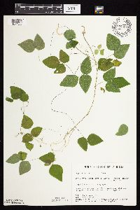 Amphicarpaea bracteata (L.) Fernald 734858[1074566]Severson, M. 6871980-08-06 United States, Minnesota, Becker, Becker Co. Green Water Lake Natural Area: 5 mi. W of Ponsford. NW1/4 SE1/4 Sec. 33, T141N, R38W.;Greenwater Lake Scientific Natural Area / White Earth Indian Reservation;141N;38W;33, 46.9838935 -95.4976994 |
MIN:Plants | 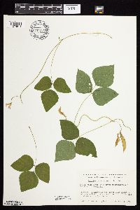 Amphicarpaea bracteata (L.) Fernald 737276[1074511]Kachman, R. 4431980-08-23 United States, Minnesota, Freeborn, White Woods County Park. Freeborn Co, to the north of the power line right-of-way where line crosses the top of the hill in White Woods Nature Park.. 101N 22W 10, 43.5645499 -93.4581322 |
MIN:Plants | 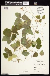 Amphicarpaea bracteata (L.) Fernald 737980[1074512]Lounsbury, S. s.n.1977-08-24 United States, Minnesota, Saint Louis, St. Louis River Estuary, Waterfront Trail Area.;;048N;15W;02, 46.6713118 -92.2080012 |
MIN:Plants | 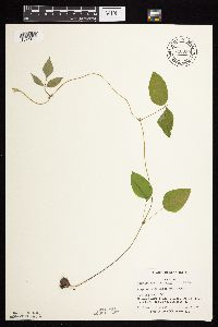 Amphicarpaea bracteata (L.) Fernald 740030[1074431]Converse, C. 10711982-06-08 United States, Minnesota, Pope, Ordway Prairie: T123N, R36W, SE1/4 NE1/4 Sec. 30.;Ordway Prairie, The Nature Conservancy;123N;36W;30, 45.4342616 -95.2450181 |
MIN:Plants | 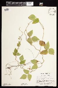 Amphicarpaea bracteata (L.) Fernald 741209[1074428]Converse, C. 18681982-07-28 United States, Minnesota, Pope, Moe Woods: T123N, R36W, SW1/4 SW1/4 Sec. 34.;Moe Woods, The Nature Conservancy;123N;36W;34, 45.4198101 -95.1833376 |
MIN:Plants | 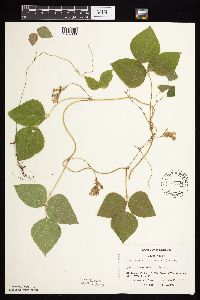 Amphicarpaea bracteata (L.) Fernald 741304[1074606]Converse, C. 19331982-08-07 United States, Minnesota, Douglas, Douglas County...Staffanson Prairie: T127N, R40W, NW1/4, NE1/4 NE1/4 NW1/4 of Sec. 18.;Staffanson Prairie, The Nature Conservancy;127N;40W;18, 45.810665 -95.7480052 |
MIN:Plants | 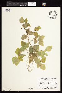 Amphicarpaea bracteata (L.) Fernald 746498[1074518]Smith, Welby 55951981-08-26 United States, Minnesota, Mower, Wild Indigo Scientific Natural Area. Wild Indigo Scientific and Natural Area. Ca. 1/2 mi. SW of the jct. on Hwy. 56 and Hwy. 2 in Brownsdale. SE1/4 SW1/4 S Wild Indigo Scientific and Natural Area. Ca. 1/2 mi. SW of the jct. on Hwy. 56 and Hwy. 2 in Brownsdale. SE1/4 SW1/4 Sec. 9, T103N, R17W.. 103N 17W 9, 43.739626 -92.8792409 |
MIN:Plants | 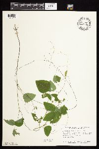 Amphicarpaea bracteata (L.) Fernald 746575[1074516]Smith, Welby 57021981-09-04 United States, Minnesota, Wright, Wright Co. Floodplain of the North Fork Crow River, at the Hwy. 3 crossing near French Lake. SW1/4 NW1/4 Sec. 22, T120N Wright Co. Floodplain of the North Fork Crow River, at the Hwy. 3 crossing near French Lake. SW1/4 NW1/4 Sec. 22, T120N, R28W.. 120N 28W 22, 45.1895171 -94.1857239 |
MIN:Plants | 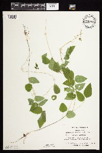 Amphicarpaea bracteata (L.) Fernald 746748[1074504]Englebretson, E. 10031982-08-08 United States, Minnesota, Hennepin, Hardscrabble Woods: T117N, R24W in Sec. 26.;Hardscrabble Woods, The Nature Conservancy;117N;24W;26, 44.9131703 -93.6760053 |
MIN:Plants | 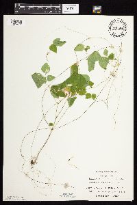 Amphicarpaea bracteata (L.) Fernald 746846[1074517]Englebretson, E. 1041982-08-08 United States, Minnesota, Hennepin, M.G. Tusler Sanctuary: T117N, R24W in Sec. 26.;M G Tusler Sanctuary, The Nature Conservancy;117N;24W;26, 44.9131703 -93.6760053 |
MIN:Plants | 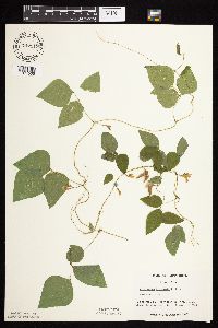 Amphicarpaea bracteata (L.) Fernald 747112[1074505]Galatowitsch, S. 6641982-08-18 United States, Minnesota, Houston, Caledonia Oaks: T102N, R05W, E1/2 SW1/4 Sec. 24.;Caledonia Oaks, The Nature Conservancy;102N;05W;24, 43.6231026 -91.3824233 |
MIN:Plants | 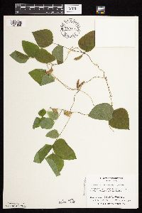 Amphicarpaea bracteata (L.) Fernald 753125[1074608]Boe, J. 20501983-08-27 United States, Minnesota, Kittson, Norway Dunes: NW1/4 NE1/4 Sec. 10; T160N, R46W.;Norway Dunes, The Nature Conservancy;160N;46W;10, 48.6957357 -96.5727704 |
MIN:Plants | 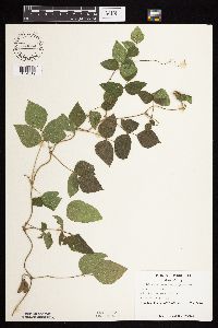 Amphicarpaea bracteata (L.) Fernald 753554[1074519]Duxbury, Alexis 23781983-09-03 United States, Minnesota, Murray, Lundblad Prairie: W1/2 NW1/4 Sec. 1, T105N, R41W.;Lundblad Prairie Scientific Natural Area;105N;41W;1, 43.9278165 -95.7133858 |
MIN:Plants | 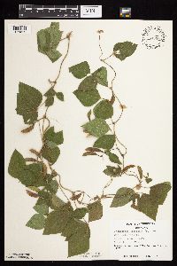 Amphicarpaea bracteata (L.) Fernald 753558[1074520]Duxbury, Alexis 23961983-09-05 United States, Minnesota, Nobles, Compass Prairie: part of SE1/4 SW1/4 Sec. 3; T101N, R41W.;Compass Prairie Scientific Natural Area;101N;41W;3, 43.5801077 -95.7438528 |
MIN:Plants | 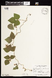 Amphicarpaea bracteata (L.) Fernald 758740[1074526]Smith, Welby 72891982-08-15 United States, Minnesota, Wright, Wright Co. About 2 1/2 mi. WNW of Maple Lake. Adjacent to Hwy. 55. SW1/4 SW1/4 Sec. 35, T121N, R27W.;;121N;27W;35, 45.2460532 -94.0453538 |
MIN:Plants | 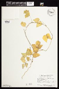 Amphicarpaea bracteata (L.) Fernald 759023[1074506]Smith, Welby 76121982-09-11 United States, Minnesota, Dakota, Fort Snelling State Park. Dakota County...Fort Snelling State Park. In the Minnesota Valley 1/2 mi. E of Gun Club Lake. SE1/4 NW1/4 Sec. 4, T27N, R23W.. 027N 23W 4, 44.8549971 -93.1772975 |
MIN:Plants |  Amphicarpaea bracteata (L.) Fernald 759249[1074507]Smith, Welby 69171982-07-28 United States, Minnesota, Mower, Racine Prairie Scientific Natural Area. Racine Prairie State Scientific and Natural Area. Strip adjacent to the E side of Hwy. 63 and, ca. 2 mi. N of Racine. Racine Prairie State Scientific and Natural Area. Strip adjacent to the E side of Hwy. 63 and, ca. 2 mi. N of Racine. NE1/4 NE1/4 Sec. 22, T104N, R14W.. 104N 14W 22, 43.7976425 -92.4992666 |
MIN:Plants |  Amphicarpaea bracteata (L.) Fernald 763386[1074548]Lugger, O. s.n.1900-09-00 United States, Minnesota, Blue Earth, Mankato;;108N;26W;00, 44.17072 -93.992534 |
MIN:Plants |  Amphicarpaea bracteata (L.) Fernald 764996[1074500]Lugger, O. s.n.1900-08-00 United States, Minnesota, Goodhue, Zumbrota;;110N;15W;31, 44.2894248 -92.6611953 |
MIN:Plants |  Amphicarpaea bracteata (L.) Fernald 770747[1074508]Smith, Welby 86661983-08-16 United States, Minnesota, Mower, Lake Louise State Park. Lake Louise State Park, ca. 1/5 mi. NW of Le Roy. Wood on the N bank of the Iowa River. NE1/4 NW1/4 Sec. 28, T101N, R1 Lake Louise State Park, ca. 1/5 mi. NW of Le Roy. Wood on the N bank of the Iowa River. NE1/4 NW1/4 Sec. 28, T101N, R14W.. 101N 14W 28, 43.5220987 -92.5189584 |
MIN:Plants | 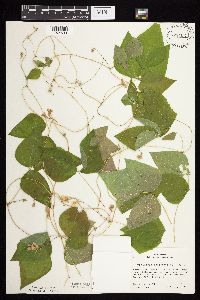 Amphicarpaea bracteata (L.) Fernald 773402[1074509]Boe, J. 16191979-08-15 United States, Minnesota, Lake of the Woods, Wheeler's Point. Near shore of Lake of the Woods. T162N, R32W, NE1/4 Sec. 24.;;162N;32W;24, 48.8377135 -94.7080128 |
MIN:Plants | 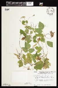 Amphicarpaea bracteata (L.) Fernald 774479[1074510]Monson, Paul s.n.1983-08-31 United States, Minnesota, Saint Louis, Voyageurs National Park. R17W, T68N, NE1/4 Sec. 26. Mukooda Lake. Portage at Winter Road at NE corner.;Voyageurs National Park;068N;17W;26, 48.3448952 -92.4874577 |
MIN:Plants | 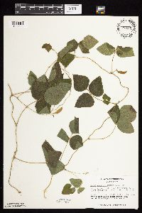 Amphicarpaea bracteata (L.) Fernald 778100[1074522]Duxbury, Alexis 21801983-08-15 United States, Minnesota, Lincoln, Hole-in-the-Mountain Prairie, The Nature Conservancy. Hole-in-the-Mountain Prairie: Portions of S1/2 Sec. 19, and SW1/4 Sec. 20; T109N, R45W. Restricted to narrow zone alon Hole-in-the-Mountain Prairie: Portions of S1/2 Sec. 19, and SW1/4 Sec. 20; T109N, R45W. Restricted to narrow zone along margin of ditch on western edge of preserve.. 109N 45W , 44.2337348 -96.291139 |
MIN:Plants | 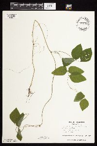 Amphicarpaea bracteata (L.) Fernald 778110[1074577]Duxbury, Alexis 22481983-08-16 United States, Minnesota, Redwood, Redwood Co. Wahpeton Prairie: S1/2 NW1/4 Sec. 29; T110N, R38W.;Wahpeton Prairie, The Nature Conservancy;110N;38W;29, 44.3047823 -95.4408133 |
MIN:Plants | 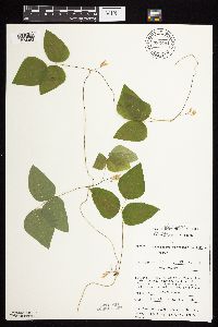 Amphicarpaea bracteata (L.) Fernald 782481[1074458]Tenney, M. 5171982-08-10 United States, Minnesota, Winona, Whitewater State Park. Winona Co. T107N, R12W, Sec. 19, SW1/4 SE1/4 NW1/4.;Whitewater State Park;107N;12W;19, 44.056381 -92.0691934 |
MIN:Plants | 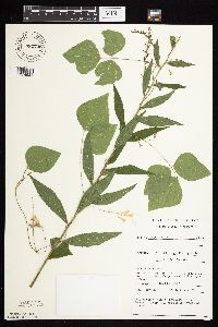 Amphicarpaea bracteata (L.) Fernald 782740[1074521]Tenney, M. 5111982-08-05 United States, Minnesota, Fillmore, Forestville State Park. Fillmore Co. T102N, R12W, Sec. 24, SW1/4 NW1/4 NW1/4 SW1/4.;Forestville State Park;102N;12W;24, 43.6234111 -92.2191515 |
MIN:Plants | 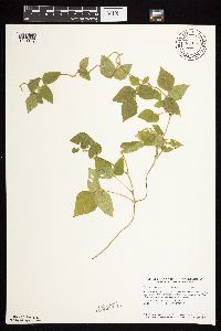 Amphicarpaea bracteata (L.) Fernald 787163[1074459]Smith, Welby 110781985-08-13 United States, Minnesota, Rock, Rock County ... Blue Mounds State Park, about 3 miles north-northeast of Luverne ... SW1/4 NW1/4 Sec. 25, T103N, R45W;Blue Mounds State Park;103N;45W;25, 43.6963882 -96.1897202 |
MIN:Plants | 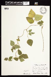 Amphicarpaea bracteata (L.) Fernald 787229[1074461]Smith, Welby 110031985-08-10 United States, Minnesota, Dodge, Iron Horse Prairie Scientific Natural Area. Dodge Co. Iron Horse State Scientific and Natural Area, ca. 1 1/2 mi. S of Hayfield. NW1/4 SE1/4 Sec. 27, T105N, R17W. Dodge Co. Iron Horse State Scientific and Natural Area, ca. 1 1/2 mi. S of Hayfield. NW1/4 SE1/4 Sec. 27, T105N, R17W. 105N 17W 27, 43.8675003 -92.8486099 |
MIN:Plants | 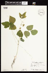 Amphicarpaea bracteata (L.) Fernald 787511[1074524]Smith, Welby 106371985-07-01 United States, Minnesota, Wright, Wright Co. Near the SW shore of Schmidt Lake. NW1/4 SE1/4 Sec. 25, T120N, R25W;M Schmidt Crawford Woods Scientific Natural Area;120N;25W;25, 45.172755 -93.7759866 |
MIN:Plants | 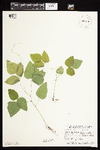 Amphicarpaea bracteata (L.) Fernald 787529[1074523]Smith, Welby 106171985-07-01 United States, Minnesota, Hennepin, Wolsfeld Woods SNA. Hennepin County ... Wolsfeld Woods State Scientific and Natural Area, about 2 1/2 miles west of Plymouth ... SW1/4 NE1/4 Sec. 27, T118N, R23W. 118N 23W 27, 45.002224 -93.5733337 |
MIN:Plants | 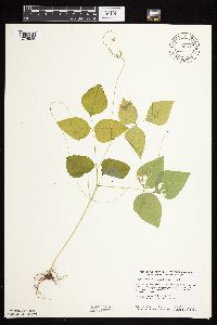 Amphicarpaea bracteata (L.) Fernald 792092[1074525]Smith, Welby 105991985-07-01 United States, Minnesota, Stearns, Stearns Co. Partch Woods State Scientific and Natural Area, ca. 3 1/2 mi. ENE of Avon. SE1/4 NW1/4 Sec. 19, T125N, R29W;Partch Woods Scientific Natural Area;125N;29W;19, 45.6222229 -94.3777771 |
MIN:Plants | 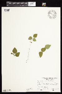 Amphicarpaea bracteata (L.) Fernald 794058[1074527]Wheeler, Gerald 63811982-08-11 United States, Minnesota, Mahnomen, Mahnomen Co. Approx. 1.5 mi N of the jct. of Rt. 113 and Rt. 4 (W side of road on Rte. 4). T143N, R39W, Sec. 19.;White Earth Indian Reservation;143N;39W;19, 47.1869818 -95.6681393 |
MIN:Plants | 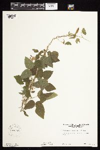 Amphicarpaea bracteata (L.) Fernald 795713[1074427]Sanford, J. s.n.1947-08-02 United States, Minnesota, Clearwater, Itasca State Park, E side of N arm of Itasca Lake.;Itasca State Park;143N;36W;, 47.229174 -95.194411 |
MIN:Plants | 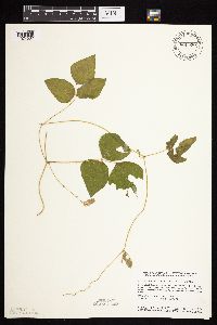 Amphicarpaea bracteata (L.) Fernald 800930[1074532]Smith, Welby 124071986-08-10 United States, Minnesota, Wabasha, Dorer Memorial Hardwood State Forest. Wabasha County ... Snake Creek Recreation Area, about 3 miles south of Kellogg. NE1/4 SE1/4 Sec. 10 T109N, R10W. 109N 10W 10, 44.2569427 -91.9916687 |
MIN:Plants | 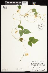 Amphicarpaea bracteata (L.) Fernald 800985[1074614]Smith, Welby 124971986-08-21 United States, Minnesota, Anoka, Lamprey Pass Wildlife Management Area. Anoka Co. Lamprey Pass State Wildlife Management Area, about 2 mi. SW of Forest Lake. NW1/4 SE1/4 Sec. 13 T32N, R22W. 032N 22W 13, 45.259809 -93.027734 |
MIN:Plants | 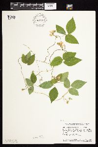 Amphicarpaea bracteata (L.) Fernald 801010[1074453]Smith, Welby 124591986-08-11 United States, Minnesota, Goodhue, Goodhue County ... Hay Creek Recreation Area, about 2 miles south of Red Wing ... NE1/4 NE1/4 Sec. 12, T112N, R15W;Dorer Memorial Hardwood State Forest;112N;15W;12, 44.5247231 -92.5538864 |
MIN:Plants | 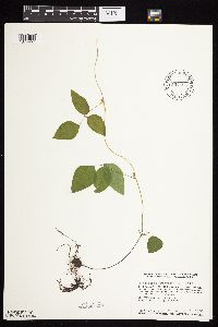 Amphicarpaea bracteata (L.) Fernald 804658[1074457]Smith, Welby 116291986-06-03 United States, Minnesota, Mower, Brandt-Larson State Wildlife Management Area, ca. 4 mi. NE of Lyle. Along Otter Creek. NE1/4 SW1/4 Sec. 16, T101N, R17;Brandt-Larson Wildlife Management Area;101N;17W;16, 43.5469437 -92.8813858 |
MIN:Plants | 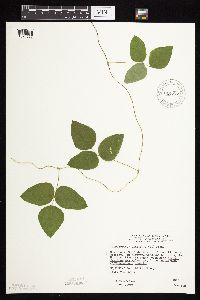 Amphicarpaea bracteata (L.) Fernald 814777[1074567]Wheeler, Gerald 109541988-06-26 United States, Minnesota, Traverse, ca 3 mi SW of Wheaton; E of Rte 27, near airport; bordering the Mustinka River (S bank), N1/2 N1/2 S26, T127N, R47W (Lak ca 3 mi SW of Wheaton; E of Rte 27, near airport; bordering the Mustinka River (S bank), N1/2 N1/2 S26, T127N, R47W (Lake Twp). 127N 47W 26, 45.7813539 -96.5418855 |
MIN:Plants | 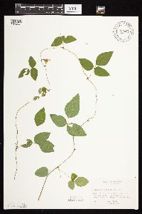 Amphicarpaea bracteata (L.) Fernald 816401[1074561]Bender, J. s.n.1986-08-07 United States, Minnesota, Washington, Belwin Outdoor Education Laboratory, T28N, R20W, S10;Belwin Outdoor Education Laboratory;028N;20W;10, 44.9271878 -92.7918522 |
MIN:Plants | 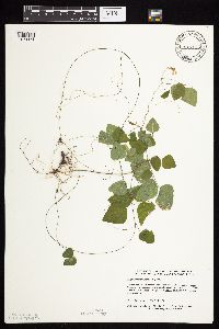 Amphicarpaea bracteata (L.) Fernald 817115[1074471]Delaney, B. 892891989-08-24 United States, Minnesota, Isanti, On E side of West Twin Lake. NW1/4 SW1/4 Sec. 11, T34N, R22W.;;034N;22W;11, 45.4484881 -93.0519446 |
MIN:Plants | 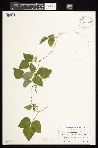 Amphicarpaea bracteata (L.) Fernald 818143[1074613]Engels, A. s.n.1991-08-18 United States, Minnesota, Aitkin, Aitkin Co. T49N, R25W, Sec. 33, NW1/4. Engels Farm, ca. 2 1/2 mi. SW of Palisade. Near Mississippi River.;;049N;25W;33, 46.6886847 -93.5163112 |
MIN:Plants | 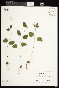 Amphicarpaea bracteata (L.) Fernald 831730[1074454]Harris, Fred 920211992-06-03 United States, Minnesota, Marshall, Marshall Co.; on 1st terrace on E bank of Red River; SW1/4 SW1/4 Sec 22 T156N R50W;;156N;50W;22, 48.3183771 -97.0759647 |
MIN:Plants | 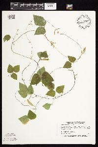 Amphicarpaea bracteata (L.) Fernald 833102[1074584]Myhre, K. 30221992-08-12 United States, Minnesota, Cass, Cass Co. Located on Partridge Point in Headquarters Bay in Leech Lake; T142N R28W SW1/4 of SW1/4 of Sec.19;Chippewa National Forest / Leech Lake Indian Reservation;142N;28W;19, 47.1040954 -94.2772948 |
MIN:Plants | 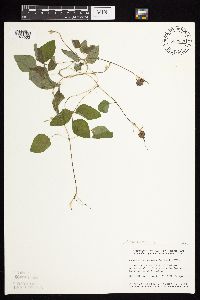 Amphicarpaea bracteata (L.) Fernald 833832[1074502]Smith, Welby 141451988-05-31 United States, Minnesota, Lac Qui Parle, Lac Qui Parle Co. About 11 mi S-SW of Madison. NE1/4 NW1/4 sec 9, T116N R45W;;116N;45W;9, 45.1458508 -96.3181817 |
MIN:Plants | 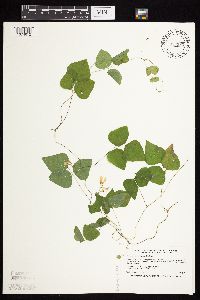 Amphicarpaea bracteata (L.) Fernald 833989[1074612]Smith, Welby 197431991-07-19 United States, Minnesota, Todd, Staples Wildlife Management Area. Todd County ... Staples State Wildlife Management Area, about 4 miles south of Staples (town) ... T133N R33W SW1/4 of NE1/4 of Sec 36. 133N 33W 36, 46.2936096 -94.7861099 |
MIN:Plants | 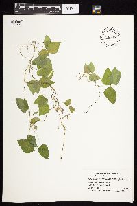 Amphicarpaea bracteata (L.) Fernald 834252[1074486]Smith, Welby 197111991-07-18 United States, Minnesota, Roseau, Roseau County ... On the south side of Elm Point in Lake of the Woods, about 0.25 mi south of the international border ... T164N R36W NE1/4 of NE1/4 of Sec 28.. 164N 36W 28, 48.9958344 -95.2916641 |
MIN:Plants | 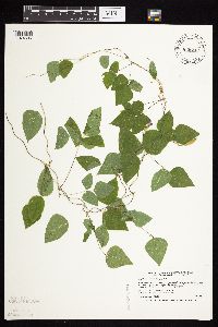 Amphicarpaea bracteata (L.) Fernald 836032[1074605]Smith, Welby 199671991-08-09 United States, Minnesota, Aitkin, Aitkin County ... South shore of Porcupine Lake, in Solena State Forest ... T45N R24W NE1/4 of NW1/4 of sec. 24;Solana State Forest;045N;24W;24, 46.3761101 -93.3177795 |
MIN:Plants | 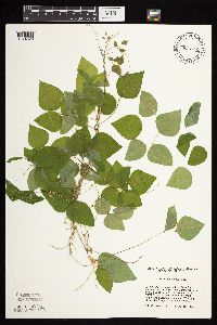 Amphicarpaea bracteata (L.) Fernald 836312[1074529]Cholewa, A. 24161995-08-10 United States, Minnesota, Aitkin, Savanna Portage State Park. Aitkin Co. Savanna Portage State Park, about 17 mi NE of McGregor, snowmobile trail at SE end of ridge NE of Savanna Lak Aitkin Co. Savanna Portage State Park, about 17 mi NE of McGregor, snowmobile trail at SE end of ridge NE of Savanna Lake, T50N R22W S6 about center of NW1/4.. 050N 22W 6, 46.845996 -93.1774497 |
MIN:Plants | 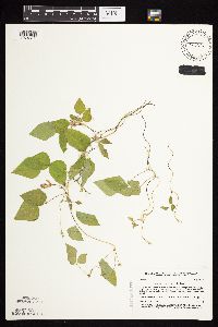 Amphicarpaea bracteata (L.) Fernald 837222[1074611]Smith, Welby 190881991-07-05 United States, Minnesota, Morrison, Camp Ripley Military Reservation. Camp Ripley Military Reservation. Morrison Co. Along the N margin of Prentice Pond (an artificial impoundment on Broken Camp Ripley Military Reservation. Morrison Co. Along the N margin of Prentice Pond (an artificial impoundment on Broken Bow Creek), about 4 km SW of Fort Ripley; UTM: 391400E 5111500N T131N R30W etc.. 131N 30W 24, 46.1293409 -94.4015749 |
MIN:Plants | 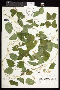 Amphicarpaea bracteata (L.) Fernald 838339[1074534]Smith, Welby 178531990-08-08 United States, Minnesota, Red Lake, Red Lake County ... At 'Old Crossing Treaty State Wayside Park'. On the N bank of the Red Lake River, about 6 miles west of the town of Red Lake Falls ... T151N R45W SE1/4 of SW1/4 sec. 27. 151N 45W 27, 47.8666649 -96.4113922 |
MIN:Plants | 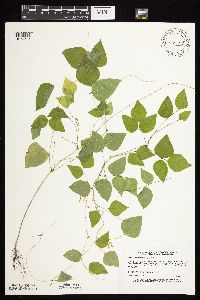 Amphicarpaea bracteata (L.) Fernald 838407[1074585]Myhre, K. 43341993-08-06 United States, Minnesota, Pine, Pine Co. Located 22 mi E of the town of Hinckley; T41N R17W SW1/4 of SE1/4 of Sec 23.;;041N;17W;23, 46.0198075 -92.4570501 |
MIN:Plants | 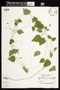 Amphicarpaea bracteata (L.) Fernald 840283[1074560]Myhre, K. 43921993-08-08 United States, Minnesota, Pine, Pine Co. Located 1 mi N of the town of Sandstone; T42N R20W SW1/4 of SW1/4 of Sec 3.;Banning State Park;042N;20W;3, 46.15073 -92.85555 |
MIN:Plants | 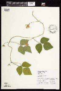 Amphicarpaea bracteata (L.) Fernald 436918[1074480]Juhnke, C. 534 CMJ FRO1999-08-24 United States, Minnesota, Goodhue, Frontenac State Park Goodhue County ... Near bridge east of Pleasant Valley Lakelet ... T112N R13W NE NE NE 14;Frontenac State Park;112N;13W;14, 44.5054851 -92.3394045 |
MIN:Plants | 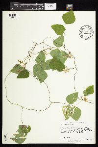 Amphicarpaea bracteata (L.) Fernald 910714[1074483]Rowe, Erika ERR2812007-08-29 United States, Minnesota, Hubbard, Paul Bunyan State Forest. Hubbard County...6 miles NW of Akeley; 0.5 mile east of Inner Forest Road in Paul Bunyan SF...west side of Waboose Lake...T141N R33W SESE S03. 141N 33W 3, 47.0527778 -94.8344444 |
MIN:Plants | 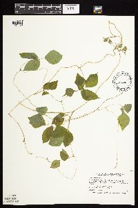 Amphicarpaea bracteata (L.) Fernald 480620[1074488]Smith, Welby 209091992-07-15 United States, Minnesota, Marshall, Old Mill State Park. Marshall County ... In Old Mill State Park, about 11 miles east of Argyle ... forest along the Middle River ... T156N R46W NW1/4 of SE1/4 of Sec 4. 156N 46W 4, 48.3602791 -96.5702744 |
MIN:Plants | 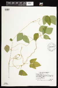 Amphicarpaea bracteata (L.) Fernald 913906[1074554]Smith, Welby 226251993-06-29 United States, Minnesota, Swift, Swift County... In Lake Monson State Park, about 17 miles northwest of Wilmar... T121N R37W SW1/4 of NW1/4 of Sec 1;Monson Lake State Park;121N;37W;01, 45.3236111 -95.2688889 |
MIN:Plants |  Amphicarpaea bracteata (L.) Fernald 911310[1074556]Smith, Welby 253881994-09-02 United States, Minnesota, Dodge, Dodge County...Along the South Branch Middle Fork Zumbro River, about 3 miles east of Mantorville...T 107N R 16W NE1/4 of SW1/4 of Sec 13. 107N 16W 13, 44.0705556 -92.6883333 |
MIN:Plants |  Amphicarpaea bracteata (L.) Fernald 476216[1074537]Smith, Welby 168841990-06-16 United States, Minnesota, Waseca, Goose Lake County Park. Waseca County ... Goose Lake County Park, at the southwest end of Goose Lake, about 2 miles east of Waseca ... T 107N R 22W NW1/4 of SW1/4 of sec 14. 107N 22W 14, 44.0705566 -93.4436111 |
MIN:Plants |  Amphicarpaea bracteata (L.) Fernald 485762[1074423]Rand, Edward s.n.1892-07-28 United States, Maine, Hancock, Mount Desert Island...Somes Stream |
MIN:Plants |  Amphicarpaea bracteata (L.) Fernald 906091[1074609]Warwick, Patrick; et al. M82008-10-15 United States, Minnesota, Ramsey, Ramsey Co, Hidden Falls Park, approx 0.5 Km south of Ford parkway along East Rivr Road.;Hidden Falls - Crosby Farm Regional Park;028N;23W;17, 44.910966 -93.197369 |
MIN:Plants | 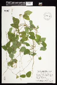 Amphicarpaea bracteata (L.) Fernald 896501[1074425]Smith, Welby 156741989-07-11 United States, Minnesota, Kanabec, Mille Lacs Wildlife Management Area. Kanabek County ... Mille Lacs State Wildlife Management Area, about 9 miles northwest of Mora ...SW1/4 SW1/4 section 16, T40N R 25W. 040N 25W 16, 45.9511111 -93.4711111 |
MIN:Plants | 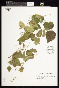 Amphicarpaea bracteata (L.) Fernald 923835[1074424]Smith, Welby 235501993-08-11 United States, Minnesota, Isanti, 13 miles southwest of Cambridge. NW1/4 of SW1/4 of section;Lyndon Cedarglade County Park;034N;25W;13, 45.4377778 -93.4075 |
MIN:Plants | 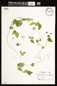 Amphicarpaea bracteata (L.) Fernald 921211[1122564]Smith, Welby 249831994-07-27 United States, Minnesota, Crow Wing, Crow Wing State Park, about 4 miles southwest of Barrows...T 44N R 32W NW1/4 of SE1/4 of Sec 23;Crow Wing State Park;044N;32W;23, 46.2772222 -94.3391667 |
MIN:Plants | 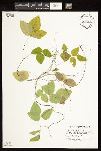 Amphicarpaea bracteata (L.) Fernald 921264[1122556]Smith, Welby 247811994-07-14 United States, Minnesota, Koochiching, Koochiching State Forest. Along the Big Fork River, about 15 mi south of the town of Big Fork [sic; actually Big Falls]... T 63N R 27W NW1/4 of NE1/4 of Sec 14. 063N 27W 14, 47.9538889 -93.755 |
Google Map
Google Maps is a web mapping service provided by Google that features a map that users can pan (by dragging the mouse) and zoom (by using the mouse wheel). Collection points are displayed as colored markers that when clicked on, displays the full information for that collection. When multiple species are queried (separated by semi-colons), different colored markers denote each individual species.