University of Minnesota
http://www.umn.edu/
612-625-5000
http://www.umn.edu/
612-625-5000
Minnesota Biodiversity Atlas
Bell Museum
Dataset: MIN-Plants
Taxa: Equisetaceae
Search Criteria: excluding cultivated/captive occurrences
Bell Museum plants | |
 MIN:Plants | 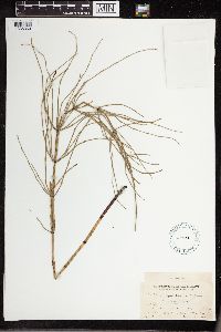 54788[1336360]Eaton, Alvah A. 38c1904-07-06 United States, Maine, Ft. Kent; St. John River |
MIN:Plants | 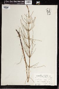 54205[1336453]Eaton, A.A. 1904-07-06 United States, Maine, St. John River, Fort Kent |
MIN:Plants | 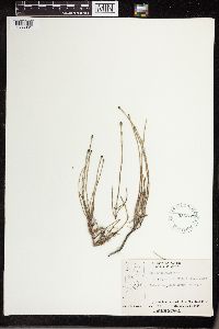 556862[1336361]Moir, D.R. 20961953-07-25 Canada, Ontario, 15 miles from the mouth of the Black Duck River, 56.80017 -89.05015 |
MIN:Plants | 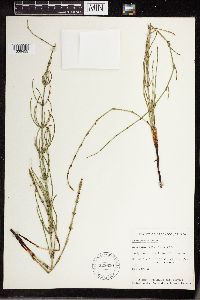 528650[1336455]Gillett, J.M. 1950-07-07 Canada, Labrador, Goose Bay |
MIN:Plants | 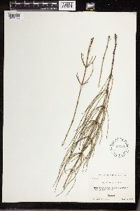 534926[1336456]Ahles, H.E. 1952-07-04 United States, Vermont, Orleans, edge of Willoughby Lake |
MIN:Plants | 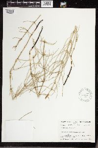 579688[1336457]Raup, H.M. 1939-07-16 Canada, Alberta, Mackenzie District, vicinity of Brintnell Lake, 55.800579 -114.714607 |
MIN:Plants | 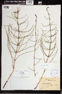 388176[1336458]Wadmond, S.C. 1907-07-11 United States, Wisconsin, Douglas, Gordan |
MIN:Plants | 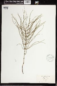 581172[1336459]Dutton, D. Lewis 1922-08-03 United States, Vermont, Brandon, 152m |
MIN:Plants |  581182[1336460]Dutton, D. Lewis 1922-06-03 United States, Massachusetts, Leicester, 42.245926 -71.908684, 122m |
MIN:Plants |  54792[1336362]Eaton, Alvah A. 38a1904-07-06 United States, Maine, St. John R.; Fort Kent. |
MIN:Plants |  380592[1336461]Clausen, Robert T. 1939-07-04 United States, New York, Tompkins, Cayuga Lake, 122m |
MIN:Plants |  53554[1336462]Spetzman, L.A. 1951-07-08 United States, Alaska, Sagavanirktok River |
MIN:Plants |  416139[1336463]Spetzman, L.A. 1950-07-17 United States, Alaska, Ncatak & Kugururok Rivers |
MIN:Plants | 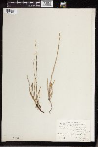 54794[1336363]Eaton, Alvah A. 37B1904-07-06 United States, Maine, shore of St. John River; Ft. Kent |
MIN:Plants | 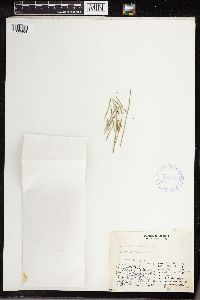 408308[1336464]Spetzman, L.A. 1949-07-17 United States, Alaska, Kanayut Lake [Kanayut River, Kanayut Bluff], 68.746944 -151.159167, 914m |
MIN:Plants | 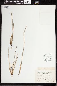 54791[1336364]Eaton, Alvah A. 37031904-07-06 United States, Maine, shore of St. John River; Ft. Kent |
MIN:Plants |  569366[1336465]Thieret, John W. 1961-07-15 Canada, Northwest Territories, Mackenzie River, Yellowknife Highway |
MIN:Plants | 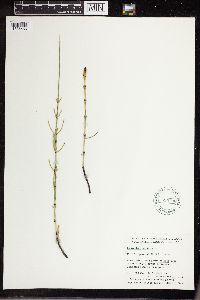 595736[1336466]Cody, W.J. 1955-06-20 Canada, Northwest Territories, Mackenzie District, Fort Simpson |
MIN:Plants | 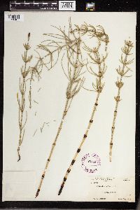 264616[1336467]Manning, W.H. 1923-06-10 United States, New York, Tompkins, valley of Cayuga Inlet, Ithaca |
MIN:Plants | 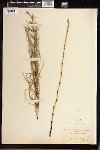 54799[1336365]Hill, A.J. 391900-06-00 Canada, British Columbia, New Westminster |
MIN:Plants | 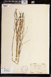 388175[1336468]Pringle, C.G. 1879-08-04 Canada, Near Sorel, shore of Richelieu River |
MIN:Plants | 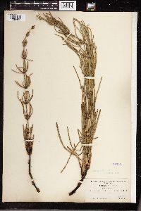 354950[1336469]Macoun, John 1905-06-16 Canada, British Columbia, Selkirk, near Lardo, 50.15 -116.983333, 549m |
MIN:Plants |  594735[1336366]Baldwin, W.K.W. 90741961-07-08 Canada, Ontario, Kenora District; Minnitaki Lake: southeaster bay, inlet of English R., 49.933333 -91.766667 |
MIN:Plants |  54798[1336470]Macoun, John 1877-06-00 Canada, Ontario, Belleville |
MIN:Plants |  812072[1336471]Bursik, R. 1987-06-23 United States, Idaho, Clearwater, St. Joe National Forest, Pinchot Marsh. 24 miles E of Clarkia. T43N R4E S26, 1645m |
MIN:Plants |  812073[1336472]Bursik, R. 1987-06-21 United States, Idaho, Valley, Payette National Forest, T19N T6E S36, 1889m |
MIN:Plants | 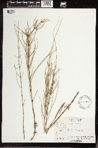 557558[1336473]Moir, D.R. 1953-07-25 Canada, Ontario, 15 miles from the mouth of the Black Duck River, 56.80017 -89.05015 |
MIN:Plants | 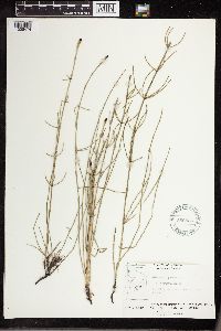 556836[1336474]Moir, D.R. 1952-07-17 Canada, Ontario, vicinity of junction of the Fawn and Otter Rivers |
MIN:Plants | 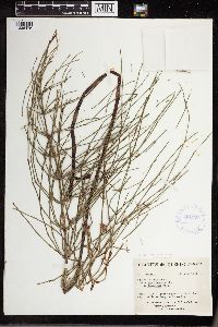 424997[1336475]Marie-Victorin 1942-08-23 Canada, Quebec, Montmorency, Saint-Joachim, Petit Cap |
MIN:Plants | 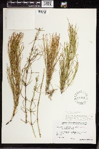 539652[1336476]Marr, J.W. 484281948-09-07 Canada, Quebec, Ungava Bay Region; On Koksoak River ca. 10 miles below mouth of Larch River., 57.766667 -69.333333 |
MIN:Plants | 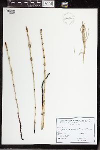 926626[1336986]Heise, W. 2008-05-30 Poland, Krakow-Podgorki Tynieckie, 220m |
MIN:Plants | 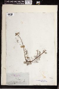 54807[1336987]Ball, J. 1850-09-00 United Kingdom, Near Aberfraw, Anglesey Island |
MIN:Plants | 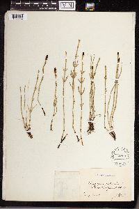 54800[1336988]Landmark, Jonas R. 1900-07-13 Norway |
MIN:Plants | 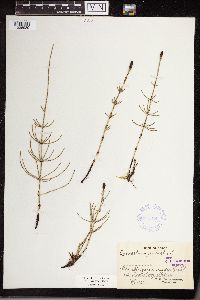 341314[1336989]Gustafsson, C.E. 1923-06-17 Sweden, Strandangarve. Gislot. Trelleborg, Skaine |
MIN:Plants | 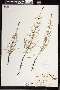 341315[1336990]Gustafsson, C.E. 1922-08-17 Sweden, Skaine, Gustafssacken, Hafgard |
MIN:Plants | 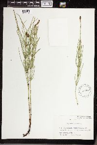 574322[1336991]Ulvinen, Tauno s.n.1961-03-23 Finland, Kiiminki, Church village. in the mouth of the Juuanjoki stream |
MIN:Plants | 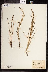 54801[1336992]Obnifk, M. 1885-05-23 Leresnnerssnnberfunderumn by Rind |
MIN:Plants | 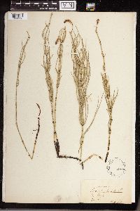 54808[1336993]Raler, C.K. 1911-06-00 Sweden, Pkofde |
MIN:Plants |  54804[1336994]Ninnfam 1885-06-00 Austria, by Fritzing |
MIN:Plants |  963538[1336995]Copineau, C. 1889-08-16 France, Grouches-Luchuel |
MIN:Plants |  54809[1336996]Bagenholm, Gosta 1894-05-00 Scandanavia, Starkkarret in Blunby, Nerke |
MIN:Plants |  54811[1336997]Kaulfuss, T. 1901-07-16 Germany, Bayem: Waldrander Gerasmuble by Vurnberg |
MIN:Plants |  54802[1336998]Kaulfuss, T. 1901-09-07 Germany, Bavaria, Frieyelstein near Narimbergam |
MIN:Plants |  54803[1336999]Kaulfuss, T. 1901-03-06 Germany, Bavaria, Vorimbergam |
MIN:Plants |  260838[1337000]Holmberg, Otto R. 1903-09-08 Sweden, Ortofta |
MIN:Plants |  54813[1338001]Prager, E. 1900-07-00 Germany, Brendenburg, Spaudan. Fiegeles. Glienicke |
MIN:Plants | 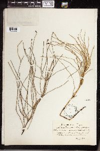 54812[1338002]Gross, R. 1907-07-24 Poland, Gestripp, Torfbreech. Kaliska, Subihum |
MIN:Plants | 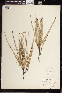 54814[1338003]Bagenholm, Gosta 1904-07-01 Sweden, Upe: Laims |
MIN:Plants | 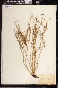 54810[1338004]Manfurz 1886-07-00 by Srindribauim |
MIN:Plants | 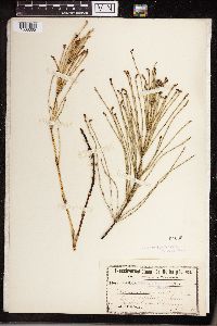 54805[1338005]Schulz, Paul F.F. 1900-06-15 Germany, Rudersdorf: at Wegen |
MIN:Plants | 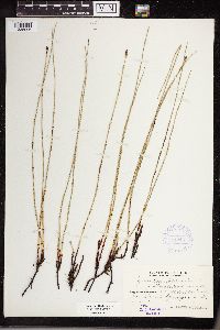 341316[1338006]Montell, Ivstvs 1931-07-21 Finland, Sphaugnetsad |
MIN:Plants | 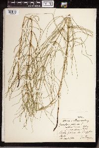 54816[1338007]Prager, E. 1900-06-28 Germany, Berlin, Gekusch. Fungfernheide |
MIN:Plants | 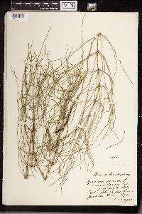 54815[1338008]Prager, E. 1900-06-28 Germany, Berlin, Gebusch der Fungfernheide |
MIN:Plants | 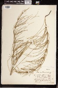 54818[1338009]Prager, E. 1900-07-00 Germany, Spaudan: Tiegelei by Grofs-Glieniski |
MIN:Plants |  972578[1398128]Verbelen, E. 361974-04-16 Belgium |
MIN:Plants |  972725[1398278]Janssens, J. 75/4941976-08-31 Belgium |
MIN:Plants |  974435[1396799]Smith, Welby R WRS363392019-07-09 United States, Minnesota, Clearwater, Iron Springs Bog State Scientific and Natural Area, about 38 km (23.6 miles) southwest of the approximate center of Bemidji at a heading of 227 degrees., 47.25339 -95.24601 |
MIN:Plants |  975993[1373546;1373633]Smith, Welby R WRS367522020-07-13 United States, Minnesota, Clearwater, Iron Springs Bog State Scientific and Natural Area, about 38 km (23.6 miles) southwest of the approximate center of Bemidji., 47.25338 -95.24598 |
MIN:Plants |  907527[1333474]Smith, Welby 290992000-09-08 United States, Minnesota, Cook, Cook County...USFS campground at Temperance River; about 6 mi N of Tofte on Co Hwy 2...T60N R4W SE1/4 of NW1/4 of Sec 33;North Shore / Superior National Forest;060N;04W;33, 47.64 -90.8469444 |
MIN:Plants |  907254[1333530]Smith, Welby 284482000-05-24 United States, Minnesota, Itasca, Chippewa National Forest. Itasca County...Along County Road 4, 1.9 miles east of jct with County Road 36; about 10 miles east of Squaw Lake (town)...T 148N R 25W NW1/4 of NE1/4 of Sec 18. 148N 25W 18, 47.6419444 -93.8866667 |
MIN:Plants |  476788[1311015]Gerdes, Lynden 24401998-05-21 United States, Minnesota, Cook, Boundary Waters Canoe Area Wilderness / Superior National Forest. T64N R03E S03NESE. Cook County ... Superior National Forest, BWCAW. Royal River area, approx. .4 miles NW of Royal Lake. On north side of the Royal River..T064N R03E S3, 48.057476 -90.046009 |
MIN:Plants |  476996[1333489]Lee, Michael MDL21791998-06-26 United States, Minnesota, Benton, Benton County ... along the railroad tracks 1-1/2 miles north of Sartell ... T37N R31W SE1/4 of NW1/4 Sec. 34;;037N;31W;34, 45.6342 -94.207437 |
MIN:Plants | 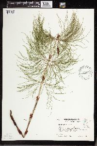 508172[1333469]Kaul, R. 64871989-06-27 United States, Minnesota, Clearwater, Clearwater Co.: Park Drive near the road to Aiton Heights lookout tower, Itasca Park.;Itasca State Park;143N;36W;, 47.197458 -95.201964 |
MIN:Plants | 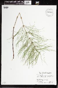 904519[1333571]Smith, Welby 281861999-08-24 United States, Minnesota, Aitkin, Aitkin County...2.5 miles N-NW of Pliny...T 45N R 23W SW1/4 of NE1/4 of Sec 20;Solana State Forest;045N;23W;20, 46.3597222 -93.2797222 |
MIN:Plants | 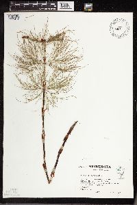 508166[1333471]Kaul, R. 64871989-06-27 United States, Minnesota, Clearwater, Clearwater Co.; Park Drive near the road to Aiton Heights lookout tower, Itasca Park;Itasca State Park;143N;36W;, 47.197458 -95.201964 |
MIN:Plants | 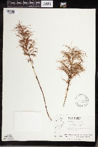 557538[1336570]Moir, D. 9091952-07-26 Canada, Ontario, Province of Ontario ... Vicinity of the junction of the Fawn and Poplar Rivers;;;;, 50 -86 |
MIN:Plants |  508176[1336579]unknown s.n.1938-00-00 United States, Wisconsin, Ashland, Madeline Is.;Apostle Islands National Lakeshore |
MIN:Plants |  907614[1333485]Smith, Welby 286842000-07-11 United States, Minnesota, Aitkin, Aitkin County...Rice Lake National Wildlife Refuge; about 5 miles SW of McGregor...T 47N R 24W SE1/4 of SW1/4 of Sec 23;Rice Lake National Wildlife Refuge;047N;24W;23, 46.5388889 -93.3422222 |
MIN:Plants |  915878[1333580]Smith, Welby 313142009-06-28 United States, Minnesota, Cook, Boundary Waters Canoe Area Wilderness / Superior National Forest. Cook County...Boundary Waters Canoe Area Wilderness, Superior National Forest. A peninsula in Long Island Lake... T 64N R 4W NE1/4 of SW1/4 of Sec 24. 064N 04W 24, 48.0091667 -90.7819444 |
MIN:Plants |  910988[1333429]Smith, Welby 308992008-06-12 United States, Minnesota, Morrison, Rice-Skunk Lake Wildlife Management Area. Morrison County...Rice-Skunk Lake State Wildlife Management Area, about 7 miles southeast of Little Falls...T 40N R 31W SE1/4 of NW1/4 of Sec 32. 040N 31W 32, 45.9222222 -94.2344444 |
MIN:Plants | 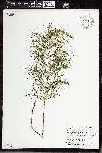 907607[1333475]Smith, Welby 289432000-08-09 United States, Minnesota, Saint Louis, St. Louis County...On the south side of Hwy 1 near the Little Fork River crossing...T 62N R 20W SE1/4 of NW1/4 of Sec 16;;062N;20W;16, 47.8591667 -92.9075 |
MIN:Plants | 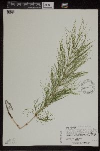 507609[1311018]Lee, Michael MDL21971998-06-30 United States, Minnesota, Benton, Benton County ... Six miles northwest of Milaca ... T38N R28W NW1/4 of NE1/4 sec. 13;;038N;28W;13, 45.785931 -93.772872 |
MIN:Plants | 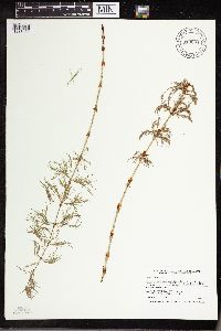 913004[1333430]Smith, Welby 242941994-07-02 United States, Minnesota, Polk, Polk County... On Nancy Sather's farm, about 1.25 miles west of Polk-Clearwater County line... T147N R39W NE1/4 of SE1/4 of Sec 11. 147N 39W 11, 47.5633333 -95.5802778 |
MIN:Plants | 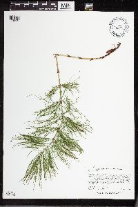 515482[1333539]Lee, Michael MDL38902004-09-24 United States, Minnesota, Becker, Pickerel Potholes Wildlife Management Area. Becker County...Pickerel Lake Potholes State Wildlife Management Area...south of Pickerel Lake, 1-1/2 miles west-southwest of Rochert...T139N R40W NW1/4 of SE1/4 Sec. 15. 139N 40W 15, 46.852129 -95.713519 |
MIN:Plants | 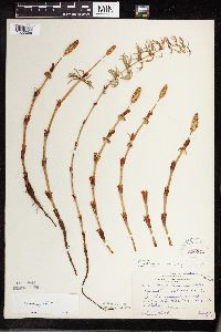 220274[1333396]Rosendahl, C. 44461924-06-08 United States, Minnesota, Aitkin, W of Lake Mill Lacs, along road to Aitkin, Aitkin Co.;;N;;, 46.243154 -93.855818 |
MIN:Plants | 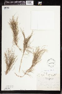 225768[1333412]Bergman, H. 31011914-08-26 United States, Minnesota, Hubbard, Benedict;;143N;32W;35, 47.15729 -94.6957 |
MIN:Plants | 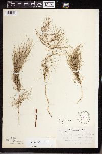 225769[1333413]Bergman, H. 31011914-08-26 United States, Minnesota, Hubbard, Benedict;;143N;32W;35, 47.15729 -94.6957 |
MIN:Plants | 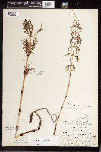 225770[1333400]Butters, F.K. 46241924-07-03 United States, Minnesota, Cook, Near "Botany Bay", North Shore Lake Superior. Cook Co.;;;;, 47.699031 -90.528027 |
MIN:Plants |  274918[1333399]Butters, F. 55451928-06-03 United States, Minnesota, Carlton, Cloquet Forest Expr. Station;;N;;, 46.72161 -92.459357 |
MIN:Plants |  275802[1333404]Moyle, J. 1791930-07-06 United States, Minnesota, Clearwater, Itasca Park; Clearwater Co. Garrison Point Bog, NE SW 15 T143 R36;Itasca State Park;143N;36W;15, 47.202782 -95.222917 |
MIN:Plants |  275805[1333382]Grant, Martin 28771929-07-21 United States, Minnesota, Hubbard, Itasca Park; Hubbard Co. La Salle Creek, NE-NE 7, T143, R35.;Itasca State Park;143N;35W;7, 47.217762 -95.161299 |
MIN:Plants |  276923[1333393]Rosendahl, C. 61961930-05-30 United States, Minnesota, Clearwater, End of West Arm, Lake Itasca, Itasca Park;Itasca State Park;143N;36W;, 47.197458 -95.201964 |
MIN:Plants | 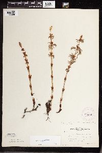 276924[1333398]Rosendahl, C. 61961930-05-30 United States, Minnesota, Clearwater, End of West Arm, Lake Itasca, Itasca Park;Itasca State Park;143N;36W;, 47.197458 -95.201964 |
MIN:Plants | 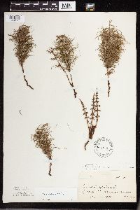 300209[1333385]unknown 101910-06-14 United States, Minnesota, Morrison, Flensburg, Morrison Co.;;N;;, 45.955243 -94.535009 |
MIN:Plants | 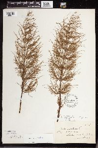 300210[1333511]unknown 131911-08-09 United States, Minnesota, Todd, R.R. track. Staples. Todd Co.;;N;;, 46.355519 -94.792241 |
MIN:Plants | 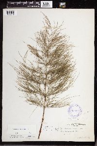 306940[1333519]Cottrell, R. s.n.1935-06-15 United States, Minnesota, Cass, Hackensack;;140N;30W;, 46.930792 -94.520552 |
MIN:Plants |  337002[1333465]Lakela, Olga 1391b1936-06-04 United States, Minnesota, Saint Louis, Across the Street Railway Building, Duluth;;N;;, 46.783273 -92.106579 |
MIN:Plants |  350212[1333468]Nielsen, E. 19581933-05-29 United States, Minnesota, Clearwater, Bohall Trail, Itasca State Park;Itasca State Park;143N;36W;, 47.197458 -95.201964 |
MIN:Plants |  351350[1333552]Nielsen, E. 24621934-05-31 United States, Minnesota, Hubbard, La Salle Creek. Itasca State Park.;Itasca State Park;143N;35W;, 47.19592 -95.107697 |
MIN:Plants |  352334[1333401]Benner, F.R. 7011929-08-22 United States, Minnesota, Cook, E Grand Portage;Grand Portage Indian Reservation / North Shore;063N;06E;, 47.964861 -89.681213 |
MIN:Plants | 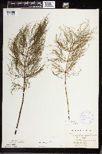 354824[1333463]Barrows, Vera 1111939-07-16 United States, Minnesota, Saint Louis, N of Wynne Lake, Biwabik;;N;;, 47.581672 -92.29395 |
MIN:Plants | 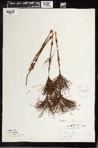 357079[1333417]Rosendahl, C.O. s.n.1918-08-00 United States, Minnesota, Itasca, Grand Rapids, Itasca Co.;;N;;, 47.2349 -93.564359 |
MIN:Plants | 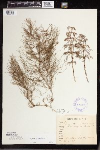 358134[1333462]unknown 121912-06-22 United States, Minnesota, Saint Louis, Meadowlands;;N;;, 47.071884 -92.732416 |
MIN:Plants | 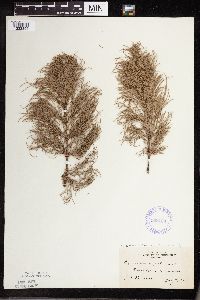 358139[1333394]Stevenson, J. s.n.1912-07-17 United States, Minnesota, Beltrami, Bemidji;;N;;, 47.536341 -94.82277 |
MIN:Plants | 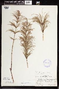 358144[1333403]Benner, F.R. 7011929-08-22 United States, Minnesota, Cook, Just E of Grand Portage, Cook Co.;Grand Portage Indian Reservation / North Shore;063N;06E;, 47.962332 -89.684303 |
MIN:Plants | 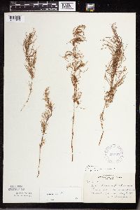 358802[1333418]Bergman, H. 30211914-08-11 United States, Minnesota, Hubbard, Benedict;;143N;32W;35, 47.15729 -94.6957 |
MIN:Plants | 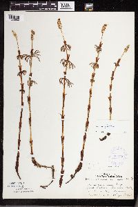 362736[1333500]Lakela, Olga 34831940-06-09 United States, Minnesota, Saint Louis, Jack Lakela`s farm, Palo, St. Louis Co.;;057N;15W;, 47.413046 -92.258987 |
MIN:Plants | 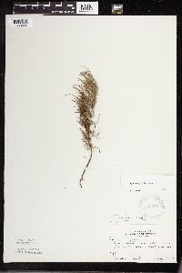 366898[1333564]Carlander, K. s.n.1940-07-14 United States, Minnesota, Lake of the Woods, Oak Island, Lake of the Woods, Lake of the Woods Co.;Northwest Angle;167N;33W;, 49.080632 -94.939312 |
MIN:Plants |  370971[1333397]Moore, John 132491940-06-25 United States, Minnesota, Aitkin, N of McGrath, Aitkin Co.;;N;;, 46.259891 -93.263524 |
MIN:Plants |  373819[1333381]Moore, John 150941941-08-09 United States, Minnesota, Hubbard, 11 mi S of Hubbard Co. N border, along Hwy 71 near Kabecona R, Hubbard Co.;;;;, 47.184183 -94.73672 |
Google Map
Google Maps is a web mapping service provided by Google that features a map that users can pan (by dragging the mouse) and zoom (by using the mouse wheel). Collection points are displayed as colored markers that when clicked on, displays the full information for that collection. When multiple species are queried (separated by semi-colons), different colored markers denote each individual species.