University of Minnesota
http://www.umn.edu/
612-625-5000
http://www.umn.edu/
612-625-5000
Minnesota Biodiversity Atlas
Bell Museum
Dataset: MIN-Plants
Taxa: Lycopodiaceae
Search Criteria: excluding cultivated/captive occurrences
Bell Museum plants | |
 MIN:Plants |  Diphasiastrum digitatum (Dillenius ex A. Braun) Holub 792818[1322852]Johnson, Gary s.n.1987-08-03 United States, Minnesota, Mille Lacs, NE1/4 S.22 T42N R26W. Mille Lacs Co.;;T042N R26W S22, 46.104839 -93.608683 |
MIN:Plants |  Diphasiastrum digitatum (Dillenius ex A. Braun) Holub 814865[1322862]Bender, J. s.n.1986-09-04 United States, Minnesota, Washington, Washington Co.; Vicinity of Belwin Outdoor Education Laboratory, T28N R20W S15 se1/4 nw1/4; south side of county road 21;;028N;20W;15, 44.914129 -92.79392 |
MIN:Plants |  Diphasiastrum digitatum (Dillenius ex A. Braun) Holub 428603[1305818]Walton, G. 24441997-05-29 United States, Minnesota, Carlton, Carlton Co.; T46N, R19W, ne/nw Sec.28, Skelton;;046N;19W;28, 46.4453 -92.753537 |
MIN:Plants |  Diphasiastrum digitatum (Dillenius ex A. Braun) Holub 428604[1322858]Walton, G. 24301997-05-27 United States, Minnesota, Carlton, Carlton Co.; T48N, R17W, sw 1/4 of Sec. 8, Carlton on north side of County 3.;;048N;17W;8, 46.656476 -92.522644 |
MIN:Plants | 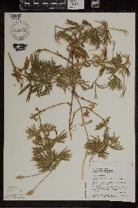 Diphasiastrum digitatum (Dillenius ex A. Braun) Holub 436601[1305816]Walton, G. 24431997-05-29 United States, Minnesota, Carlton, Carlton Co.; T47N, R19W, ne 1/4 of nw 1/4 of Sec.28, Skelton Township.;;047N;19W;28, 46.4453 -92.753537 |
MIN:Plants | 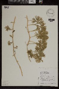 Diphasiastrum digitatum (Dillenius ex A. Braun) Holub 436605[1305812]Walton, G. 24431997-05-29 United States, Minnesota, Carlton, Carlton Co.; T47N, R19W, ne 1/4 of nw 1/4 of Sec.28, Skelton Township;;047N;19W;28, 46.4453 -92.753537 |
MIN:Plants | 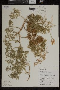 Diphasiastrum digitatum (Dillenius ex A. Braun) Holub 436606[1305810]Walton, G. 24461997-05-29 United States, Minnesota, Carlton, Carlton Co.; T46N, R19W, ne/nw Sec.28, Skelton;;046N;19W;28, 46.4453 -92.753537 |
MIN:Plants | 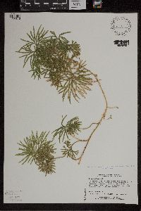 Diphasiastrum digitatum (Dillenius ex A. Braun) Holub 440502[1305815]Lee, Michael MDL11391995-08-31 United States, Minnesota, Wabasha, Wabasha Co.; sand terrace below 150ft, N-facing bluff along Sand Ditch 2 mi SE of Theilman; T109N R11W NWNWSE 5;Dorer Memorial Hardwood State Forest;109N;11W;5, 44.262814 -92.154689 |
MIN:Plants | 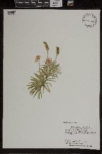 Diphasiastrum digitatum (Dillenius ex A. Braun) Holub 444542[1305817]Dahle, R. 970281997-08-13 United States, Minnesota, Aitkin, Savanna State Forest. Aitkin County...About nine miles northeast of the town of McGregor. About a half mile northwest of Horseshoe Lake...T 49 R 23 SW1/4 of SE1/4 of Sec 14. 049N 23W 14, 46.7258333 -93.2205556 |
MIN:Plants | 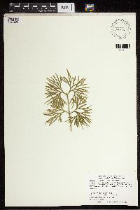 Diphasiastrum digitatum (Dillenius ex A. Braun) Holub 456280[1322854]Dahle, R. 960401996-11-06 United States, Minnesota, Aitkin, Wealthwood State Forest. Aitkin County...In Wealthwood State Forest, about one half mile north of Highway #18, just north of the parking area at the north end of the North Shore Forest Road...T 45N R 27W SW1/4 of SE1/4 of Sec 24. 045N 27W 24, 46.3622222 -93.6944444 |
MIN:Plants | 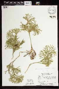 Diphasiastrum digitatum (Dillenius ex A. Braun) Holub 473654[1322859]Myhre, K. 15751992-04-26 United States, Minnesota, Itasca, Chippewa National Forest / Leech Lake Indian Reservation. Itasca Co.; 3 miles Northwest of Little Cut Foot Sioux Lake, the SW1/4 of the NE NW of sect. 14, USFS compartment 57 sta Itasca Co.; 3 miles Northwest of Little Cut Foot Sioux Lake, the SW1/4 of the NE NW of sect. 14, USFS compartment 57 stand 1, Deer River district; T 147N R 27W NE1/4 of NW1/4 of sec 14. 147N 27W 14, 47.556419 -94.31977 |
MIN:Plants |  Diphasiastrum digitatum (Dillenius ex A. Braun) Holub 477996[1322860]Myhre, K. 27751992-07-20 United States, Minnesota, Cass, Cass Co.; located 1.3 miles north of Norway Lake; T 138N R 29W NW1/4 of NW1/4 of Sec 19;;138N;29W;19, 46.758948 -94.404115 |
MIN:Plants | 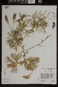 Diphasiastrum digitatum (Dillenius ex A. Braun) Holub 506125[1305813]Cholewa, A.F. 24931996-08-12 United States, Minnesota, Aitkin, Savanna State Forest. Aitkin Co. Savanna State Forest, North Aitkin Lake road, about 1 airmile N of Aitkin Lake, at junction with forest track heading north. T50N R23W S8 SW1/4. 050N 23W 8, 46.829053 -93.289316 |
MIN:Plants | 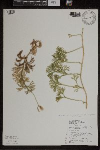 Diphasiastrum digitatum (Dillenius ex A. Braun) Holub 519242[1305811]Walton, G. 26741997-09-15 United States, Minnesota, Lake, Superior National Forest; T60N, R6W, sw1/4 of nw1/4 of Sec.33. Wilson Lake...Lake Co.;Superior National Forest;060N;06W;33, 47.637632 -91.097065 |
MIN:Plants | 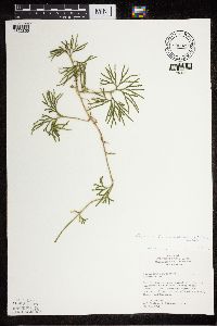 Diphasiastrum digitatum (Dillenius ex A. Braun) Holub 805822[1322855]Cholewa, A.F. 19511990-08-29 United States, Minnesota, Washington, Carpenter Nature Center. Washington Co, T26N R20W S4...Stoffel Ravine, near summit of ridge just SW of Kittentail Knob;Carpenter Nature Center;026N;20W;04, 44.768259 -92.812758 |
MIN:Plants | 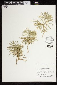 Diphasiastrum digitatum (Dillenius ex A. Braun) Holub 840694[1322861]Myhre, K. 37081993-05-26 United States, Minnesota, Pine, Pine Co.; Located one half mile east of the General C.C. Andrews State Forest; T44N R19W NE1/4 of NE1/4 of Sec 4;;044N;19W;4, 46.324271 -92.751374 |
MIN:Plants | 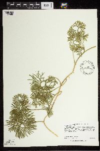 Diphasiastrum digitatum (Dillenius ex A. Braun) Holub 508772[1322853]Lee, Michael MDL22001998-06-30 United States, Minnesota, Benton, Benton County ... Six miles northwest of Milaca ... T38N R28W NW1/4 of NE1/4 Sec. 13;;038N;28W;13, 45.785931 -93.772872 |
MIN:Plants | 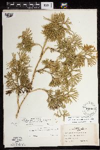 Diphasiastrum digitatum (Dillenius ex A. Braun) Holub 462956[1322865]Lakela, Olga 140821952-05-31 United States, Minnesota, Saint Louis, Floodwood Lake # 73. St. Louis Co.;;054N;21W;, 47.168272 -93.035201 |
MIN:Plants | 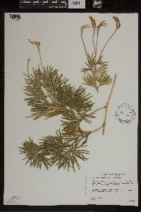 Diphasiastrum digitatum (Dillenius ex A. Braun) Holub 493112[1305814]Gerdes, Lynden 48332004-05-26 United States, Minnesota, Lake, Superior National Forest. T60N R10W S27SESE. Lake County...Superior National Forest. Approximately 10.8 miles WNW of Isabella, MN. Sandy mixed upland west and north of Stony River.. 060N 10W 27, 47.646864 -91.586152 |
MIN:Plants | 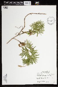 Diphasiastrum digitatum (Dillenius ex A. Braun) Holub 438404[1322844]Gerdes, Lynden 50252005-07-13 United States, Minnesota, Saint Louis, Superior National Forest. T57N R14W S08SENE St. Louis County ... Superior National Forest. South of Hoyt Lakes ... North off the St. Louis River approximately 0.30 miles SE of the Norway Point landing.. 057N 14W 8, 47.43677 -92.144224 |
MIN:Plants | 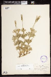 Diphasiastrum digitatum (Dillenius ex A. Braun) Holub 288693[1327164]Fellows, Dana s.n.1908-08-06 United States, Maine, Hancock, Mount Desert;Acadia National Park |
MIN:Plants | 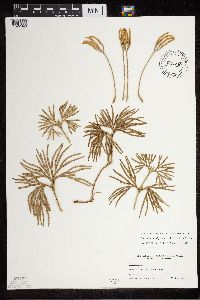 Diphasiastrum digitatum (Dillenius ex A. Braun) Holub 827849[1322848]Gunderson, Harvey s.n.1940-11-26 United States, Minnesota, Goodhue, Goodhue Co, Frontenac;112N;13W;, 44.512272 -92.375148 |
MIN:Plants | 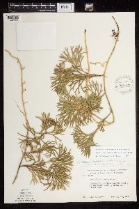 Diphasiastrum digitatum (Dillenius ex A. Braun) Holub 585512[1322868]Moore, John 259351962-05-16 United States, Minnesota, Anoka, Anoka Co.; west 1/2 of the south east 1/4, Sect. 33, Bethel Twp.;Cedar Creek National History Area;034N;23W;33, 45.38856 -93.211195 |
MIN:Plants | 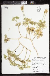 Diphasiastrum digitatum (Dillenius ex A. Braun) Holub 950810[1327165]Johnson, Elissa 782015-10-09 United States, Rhode Island, Kent, Arcadia WIldlife MAnagement Area. West Greenwich, 0.25 miles N of Plain Road, 0.2 miles W of intersection with Midway trail., 41.601731 -71.726603, 58m |
MIN:Plants | 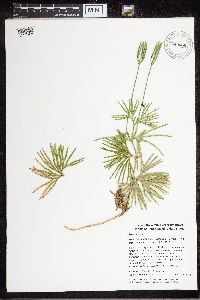 Diphasiastrum digitatum (Dillenius ex A. Braun) Holub 949066[1327166]Whitfeld, Timothy J.S. 2014-07-15 United States, Rhode Island, Kent, Big River Wildlife Management Area, West Greenwich. 1.4 miles S of intersection between Hopkins Rd and Interstate 95 |
MIN:Plants | 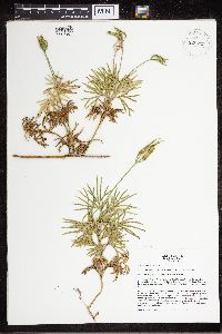 Diphasiastrum digitatum (Dillenius ex A. Braun) Holub 928725[1327167]Leoschke, Mark J. 2004-08-14 United States, Iowa, Mahaska, T76N R15W Section 30. Russel Wildlife Area, about 3 miles N of Oskaloosa |
MIN:Plants | 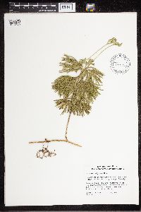 Diphasiastrum digitatum (Dillenius ex A. Braun) Holub 507934[1327168]DeMarey, Deborah M. 17741996-07-02 United States, Massachusetts, Hampden, ridge from Valley View Road and Chestnut Hill Road, old woods road running the length of the ridge |
MIN:Plants | 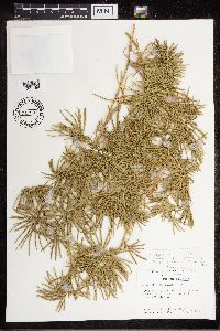 Diphasiastrum digitatum (Dillenius ex A. Braun) Holub 717997[1327169]Jones, Samuel B. 1979-04-28 United States, Georgia, Fannin, between Betty Mt. and Three Forks Mt. along road cut of GA 64. Cohutta Mts. |
MIN:Plants | 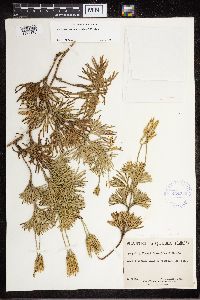 Diphasiastrum digitatum (Dillenius ex A. Braun) Holub 424753[1327170]Marie-Victorin 1941-09-07 Canada, Quebec, Portneuf, Saint-Augustin |
MIN:Plants | 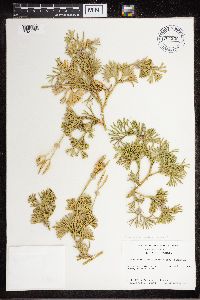 Diphasiastrum digitatum (Dillenius ex A. Braun) Holub 704556[1327171]Jones, Samuel B. 1978-09-13 United States, Georgia, Lumpkin, Hwy 60 on N side of Woody's Gap. |
MIN:Plants | 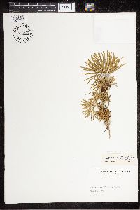 Diphasiastrum digitatum (Dillenius ex A. Braun) Holub 716246[1327172]Frye, Wilbert M. 1941-08-12 United States, West Virginia, Hampshire, Pleasant Dale |
MIN:Plants | 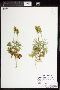 Diphasiastrum digitatum (Dillenius ex A. Braun) Holub 963029[1346619]Whitfeld, T.J.S. 23562019-08-25 United States, Minnesota, Crow Wing, US Army Corps of Engineers Gull Lake Recreation Area, campground-forest, 46.410532 -94.350684 |
MIN:Plants | 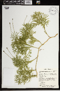 Diphasiastrum digitatum (Dillenius ex A. Braun) Holub 968022[1368585]T. J. S. Whitfeld 2207a2019-06-19 United States, Minnesota, Lake, Boundary Waters Canoe Area Wilderness, along north shoreline of Fish Dance Lake, 47.915667 -91.199361, 474m |
MIN:Plants | 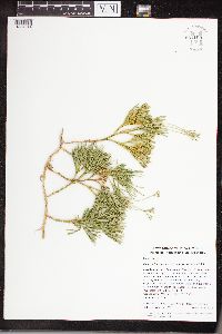 Diphasiastrum digitatum (Dillenius ex A. Braun) Holub 961100[1334244]Whitfeld, Timothy J.S. 17322018-06-12 United States, Rhode Island, Providence, Diamond Hill Reservation, 0.66 miles southeast of the intersection between West Wrentham Road and Pine Swamp Road., 42.0061667 -71.4351111 |
MIN:Plants | 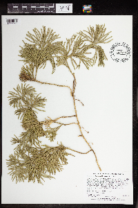 Diphasiastrum digitatum (Dillenius ex A. Braun) Holub 965186[1375852]Lee, Michael MDL51682010-04-01 United States, Minnesota, Benton, 45.69405184 -94.15843159, 326m |
MIN:Plants | 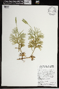 Diphasiastrum digitatum (Dillenius ex A. Braun) Holub 968174[1368789]Timothy J. S. Whitfeld 16202017-07-18 United States, Rhode Island, Providence, Snake Den State Park, 0.65 miles south of intersection betwen Greenville Avenue (Rt. 5) and Brown Avenue., 41.85136 -71.5298 |
MIN:Plants | 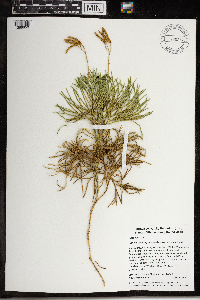 Diphasiastrum digitatum (Dillenius ex A. Braun) Holub 968254[1368850]Morgan Florsheim 522017-10-06 United States, Rhode Island, Kent, Nicholas Farm Wildlife Management Area, 0.3 miles north of intersection Nicholas and Greenhouse roads., 41.6829638889 -71.7747472222, 107m |
MIN:Plants | 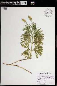 Diphasiastrum digitatum (Dillenius ex A. Braun) Holub 970898[1394366]Smith, Welby R WRS358442017-10-04 United States, Minnesota, Isanti, Twin Lakes State Scientific and Natural Area, about 7.7 km (4.8 miles) SW of North Branch at a heading of 215 degrees., 45.4529667 -93.0486833 |
MIN:Plants | 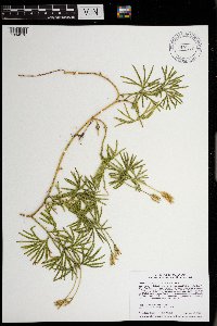 Diphasiastrum digitatum (Dillenius ex A. Braun) Holub 970908[1394376]Smith, Welby R WRS358542017-11-16 United States, Minnesota, Anoka, Boot Lake State Scientific and Natural Area, about 6.8 km (4.2 miles) E-NE of East Bethel at a heading of 70 degrees., 45.3395667 -93.1204167 |
MIN:Plants | 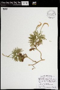 Diphasiastrum digitatum (Dillenius ex A. Braun) Holub 970917[1394385]Smith, Welby R WRS358632018-05-16 United States, Minnesota, Washington, William O'Brien State Park, about 3 km (1.8 miles) N-NE of Marine on St. Croix at a heading of 17 degrees., 45.22405 -92.7593833 |
MIN:Plants | 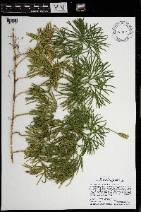 Diphasiastrum digitatum (Dillenius ex A. Braun) Holub 971151[1394620]Smith, Welby R WRS361172018-09-28 United States, Minnesota, Isanti, Twin Lakes State Scientific and Natural Area, about 7.7 km (4.8 miles) SW of North Branch at a heading of 215 degrees., 45.4529667 -93.0486833 |
MIN:Plants |  Diphasiastrum digitatum (Dillenius ex A. Braun) Holub 974403[1396767]Smith, Welby R WRS361942019-06-16 United States, Minnesota, Lake, In the Boundary Waters Canoe Area Wilderness, Superior National Forest. About 42 km (26 miles) nearly due east of the approximate center of Ely. On an island in Insula Lake (unburned by the Pagami Creek Fire of 2011)., 47.91084 -91.28675 |
MIN:Plants |  Diphasiastrum digitatum (Dillenius ex A. Braun) Holub 974389[1396753]Smith, Welby R WRS361952019-06-16 United States, Minnesota, Lake, In the Boundary Waters Canoe Area Wilderness, Superior National Forest. About 42 km (26 miles) nearly due east of the approximate center of Ely. On an island in Insula Lake (unburned by the Pagami Creek Fire of 2011)., 47.91084 -91.28675 |
MIN:Plants |  Diphasiastrum digitatum (Dillenius ex A. Braun) Holub 974354[1396718]Smith, Welby R WRS365952019-10-07 United States, Minnesota, Anoka, Carlos Avery State Wildlife Management Area; 8.75 km (5.4 miles) due west from the junction of Interstate 35 and State 22 in the town of Wyoming., 45.3365833 -93.1162833 |
MIN:Plants |  Diphasiastrum digitatum (Dillenius ex A. Braun) Holub 974312[1396676]Smith, Welby R WRS366052019-10-25 United States, Minnesota, Sherburne, Sand Dune State Forest, about 7.5 km (4.6 miles) southwest of the approximate center of Zimmerman., 45.38955 -93.64756 |
MIN:Plants | 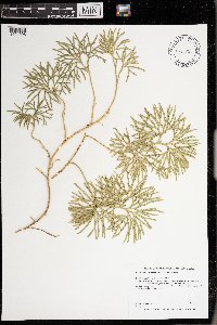 Diphasiastrum digitatum (Dillenius ex A. Braun) Holub 975855[1404908]Dunevitz, Hannah L. 10101994-09-29 United States, Minnesota, Wabasha, in Zumbro Bottoms State Forest. About 1/2 mile north of Tushaus Hill, 44.3 -92.12 |
MIN:Plants | 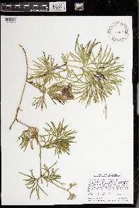 Diphasiastrum digitatum (Dillenius ex A. Braun) Holub 975914[1373467]Smith, Welby R WRS366262020-04-18 United States, Minnesota, Anoka, Lamprey Pass State Scientific and Natural Area; about 3.8 km (2.35 miles) W-SW of the approximate center of the town of Forest Lake., 45.26387 -93.02953 |
MIN:Plants | 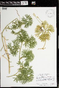 Diphasiastrum digitatum (Dillenius ex A. Braun) Holub 977665[1401253]Anderson, Derek S. 37862021-10-29 United States, Minnesota, Carlton, Fond du Lac State Forest. About 8.7 km southeast of Cromwell. About 4 km south of the intersection of State Hwy 210 and Kettle Lake Rd. At the end of Kettle Lake Rd., 46.64259 -92.78491 |
MIN:Plants | 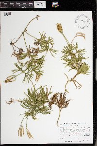 Diphasiastrum digitatum (Dillenius ex A. Braun) Holub 977614[1401202]Anderson, Derek S. 34502020-11-03 United States, Minnesota, Chisago, Chengwatana State Forest. About 9 km northeast of Rush City. About 800 meters west-southwest of Stevens Creek Landing (at the Chisago/Pine County border) on the St. Croix River., 45.72773 -92.8598 |
MIN:Plants | 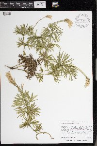 Diphasiastrum digitatum (Dillenius ex A. Braun) Holub 977526[1401112]Anderson, Derek S. 34712021-03-28 United States, Minnesota, Pine, Chengwatana State Forest. About 14 km east of Pine City. About 1 km northwest of the intersection of St. Croix Rd. (Cty. Rd. 118) and the state forest campground road. North of the Snake River., 45.82468 -92.78538 |
MIN:Plants | 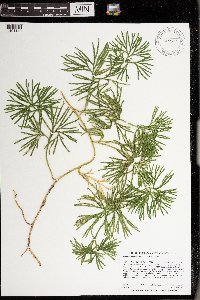 Diphasiastrum digitatum (Dillenius ex A. Braun) Holub 977553[1401140]Anderson, Derek S. 34282020-10-08 United States, Minnesota, Chisago, Carlos Avery WMA. About 4 km east-northeast of Stacy. About 470 m southwest of the Cty. Rd. 19 bridge over the Sunrise River., 45.40516 -92.93594 |
MIN:Plants | 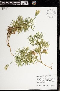 Diphasiastrum digitatum (Dillenius ex A. Braun) Holub 977551[1401138]Anderson, Derek S. 34322020-10-08 United States, Minnesota, Chisago, Carlos Avery WMA. About 6.7 km northeast of Stacy. About 1.3 km northeast of the intersection of Cty. Rd. 18 and Iris Ave., 45.43699 -92.92177 |
MIN:Plants | 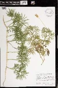 Diphasiastrum digitatum (Dillenius ex A. Braun) Holub 977552[1401139]Anderson, Derek S. 34332020-10-15 United States, Minnesota, Chisago, Carlos Avery WMA. About 3.25 km northeast of Stacy. About 600 meters northeast of the intersection of Hemmingway Ave. and 320th St., 45.41566 -92.95439 |
MIN:Plants | 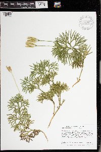 Diphasiastrum digitatum (Dillenius ex A. Braun) Holub 977620[1401208]Anderson, Derek S. 34402020-10-15 United States, Minnesota, Chisago, Carlos Avery WMA. About 3.6 km northeast of Stacy. About 780 meters northeast of the intersection of Hemmingway Ave. and 320th St., 45.41739 -92.9538 |
MIN:Plants | 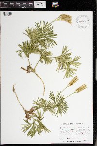 Diphasiastrum digitatum (Dillenius ex A. Braun) Holub 977616[1401204]Anderson, Derek S. 34462020-10-15 United States, Minnesota, Chisago, Carlos Avery WMA. About 3 km north-northeast of Wyoming. About 980 meters southeast of the intersection of Foxhill Ave. and 287th St., 45.35996 -92.97486 |
MIN:Plants | 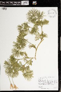 Diphasiastrum digitatum (Dillenius ex A. Braun) Holub 977537[1401124]Anderson, Derek S. 34642021-03-13 United States, Minnesota, Chisago, Carlos Avery Wildlife Management Area: Sunrise Unit. About 4.6 km northeast of Stacy. About 530 m south-southeast of the parking lot on County Road 18 (870 m east of the intersection of Hemingway Ave. and Cty. Rd. 18)., 45.42569 -92.94531 |
MIN:Plants | 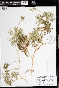 Diphasiastrum digitatum (Dillenius ex A. Braun) Holub 977317[1402901]Lee, Michael MDL65152014-06-25 United States, Minnesota, Fillmore, Rugged forested terrain along the Root River two miles southwest of Rushford, two miles east-northeast of Peterson., 43.79386781647 -91.78918244669, 299m |
MIN:Plants | 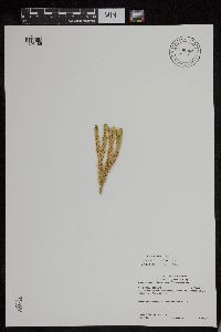 Huperzia selago (L.) Bernhardi ex Schrank & Martius 896366[1295186]Gerdes, Lynden B. 53412006-08-23 United States, Minnesota, Lake, T61N R09W S18NWNE. Superior National Forest. Approximately 13.56 miles NW of Isabella, MN and 1.50 miles S of Bald Eagle Lake., 47.803599 -91.551371 |
MIN:Plants | 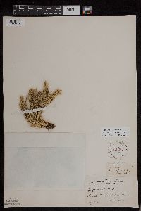 Huperzia selago (L.) Bernhardi ex Schrank & Martius 229266[1295205]Cooper, William S. 3171910-08-00 United States, Michigan, Keweenaw, Scoville Point, Isle Royale [Isle Royale National Park] |
MIN:Plants | 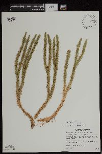 Huperzia selago (L.) Bernhardi ex Schrank & Martius 477760[1295197]Gerdes, Lynden B. 42012000-07-06 United States, Minnesota, Lake, T57N R07W S24SWNE. Little Marais. Small, northeast-facing cliff feature aprox. 1/8 mile SE of the Superior Hiking Trail and County 6 junction. Approx. 1/4 mile SE of the Finland Cemetary., 47.410745 -91.110162 |
MIN:Plants | 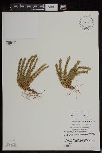 Huperzia selago (L.) Bernhardi ex Schrank & Martius 489097[1295146]Gerdes, Lynden B. 45062001-09-19 United States, Minnesota, Lake, T56N R07W S31SENE. Tettegouche State Park, Silver Bay, MN. Cliff feature approximately 1.30 miles NNE of Nicado Lake., 47.33958 -91.198054 |
MIN:Plants | 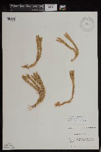 Huperzia selago (L.) Bernhardi ex Schrank & Martius 520220[1295219]Lawrence, D.B. s.n.1952-08-19 United States, Alaska, Glacier Bay National Monument. Tlingit Point area [Glacier Bay National Park], 58.7577778 -136.18 |
MIN:Plants | 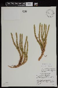 Huperzia selago (L.) Bernhardi ex Schrank & Martius 489100[1295187]Gerdes, Lynden B. 43872001-07-10 United States, Minnesota, Lake, T56N R08W S03SWNE. Finland State Forest, vicinity of Silver Bay, MN. Approximately 6.0 miles NW of town and 2.0 miles NW of Lax Lake., 47.364823 -91.335688 |
MIN:Plants | 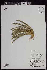 Huperzia selago (L.) Bernhardi ex Schrank & Martius 505509[1295151]Lee, Michael D. MDL3065B2001-07-18 United States, Minnesota, Lake, Along County Road 7 and the East Branch Baptism River, three miles northeast of Finland. T57N R7W S1/2 of SE1/4 of NE1/4 Sec.10., 47.374282 -91.228225 |
MIN:Plants | 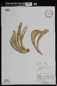 Huperzia selago (L.) Bernhardi ex Schrank & Martius 505439[1295195]Lee, Michael D. MDL2932A2001-06-12 United States, Minnesota, Lake, On the northeast side of Moose Lake 3 1/2 miles northwest of Cramer. T59N R6W NE1/4 of SW1/4 of NE1/4 Sec. 30, 47.562697 -91.137425 |
MIN:Plants | 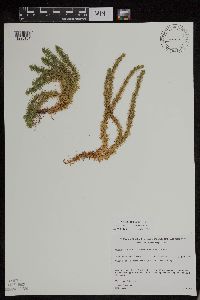 Huperzia selago (L.) Bernhardi ex Schrank & Martius 461292[1295181]Gerdes, Lynden B. 25731998-06-02 United States, Minnesota, Cook, T64N R01E S28SWSWNE. Superior National Forest, BWCAW [Boundary Waters Canoe Area Wilderness]. Clearwater Lake (Cliff 2b)., 48.08486 -90.335202 |
MIN:Plants | 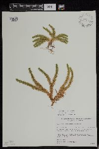 Huperzia selago (L.) Bernhardi ex Schrank & Martius 431642[1295184]Gerdes, Lynden B. 36261999-07-24 United States, Minnesota, Cook, T65N R02E S27NENW. Superior National Forest, West Pike Lake, BWCAW [Boundary Waters Canoe Area Wilderness]. Cliff feature; near south shore; approximatley 0.6 mile west of the southeast corner of the lake., 48.08566 -90.176888 |
MIN:Plants | 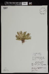 Huperzia selago (L.) Bernhardi ex Schrank & Martius 493431[1295188]Gerdes, Lynden B. 44162001-07-26 United States, Minnesota, Cook, T59N R04W S01NWSW. Leveaux Mountain, Superior National Forest. Approximately 4.2 miles NE of Tofte, 47.623034 -90.777434 |
MIN:Plants | 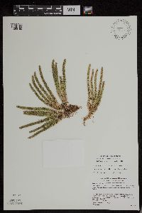 Huperzia selago (L.) Bernhardi ex Schrank & Martius 489117[1295150]Gerdes, Lynden B. 44142001-07-26 United States, Minnesota, Cook, T59N R04W S01NWSW. Leveaux Mountain, Superior National Forest. Approximately 4.1 miles NE of Tofte, 47.623034 -90.777434 |
MIN:Plants | 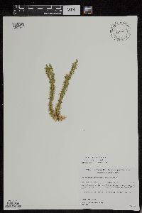 Huperzia selago (L.) Bernhardi ex Schrank & Martius 461289[1295154]Gerdes, Lynden B. 27241998-06-17 United States, Minnesota, Cook, T65N R04W S26NWSE. Superior National Forest. North and NW facing cliffs approx. 0.75 miles NE of Round Lake. South of Hwy 12 & Cross River, on rock face/cliff observable from Hwy. 12., 48.08284 -90.803294 |
MIN:Plants | 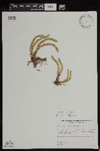 Huperzia selago (L.) Bernhardi ex Schrank & Martius 461290[1295198]Gerdes, Lynden B. 26901998-06-15 United States, Minnesota, Cook, T65N R01W S31NESW. Superior National Forest. South Hiking Trail, at edge of trail/drainage area southeast of East Otter Lake., 48.070172 -90.501305 |
MIN:Plants | 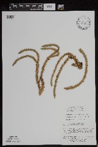 Huperzia selago (L.) Bernhardi ex Schrank & Martius 498916[1295193]Lee, Michael D. MDL29262001-06-07 United States, Minnesota, Lake, Superior National Forest. Along County Road 7 and Nine Mile Creek, 2 1/4 miles north of Cramer. T59N R6W NW1/4 of NW1/4 of NW1/4 Sec. 34, NE1/4 of NE1/4 of NE1/4 Sec. 33, 47.551557 -91.075831 |
MIN:Plants | 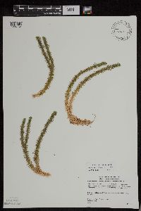 Huperzia selago (L.) Bernhardi ex Schrank & Martius 440620[1295162]Gerdes, Lynden B. 40792000-07-17 United States, Minnesota, Lake, T56N R08W S24SESW. Tettegouche State Park, northwest of Silver Bay, MN. Long, north-facing (east-west trending) cliff feature approx. 0.31 mile north of Bean Lake., 47.33958 -91.198054 |
MIN:Plants |  Huperzia selago (L.) Bernhardi ex Schrank & Martius 812022[1295029]Gerdes, Lynden B. 339B1991-05-14 United States, Minnesota, Saint Louis, T64N R12W S34 SE1/4 of NW1/4. About 5 1/2 mi N of Ely on N facing outcrop. [Boundary Waters Canoe Area Wilderness / Superior National Forest], 47.984081 -91.853681 |
MIN:Plants |  Huperzia selago (L.) Bernhardi ex Schrank & Martius 306582[1295167]Rosendahl, C.O. 62961930-08-26 United States, Minnesota, Cook, Along new road near Grand Portage Harbor. [Grand Portage Indian Reservation; T63N;R6E], 47.9667 -89.7667 |
MIN:Plants |  Huperzia selago (L.) Bernhardi ex Schrank & Martius 353683[1295169]Moyle, J.B. 14491934-07-08 United States, Minnesota, Clearwater, Itasca Park. Roadside near Schneider's resort. [tasca State Park; T143N;R36W], 47.217494 -95.234583 |
MIN:Plants |  Huperzia selago (L.) Bernhardi ex Schrank & Martius 357228[1295164]Butters, F.K. 4031937-07-12 United States, Minnesota, Cook, At W end of Clark's Bay, Pigeon Point [Grand Portage Indian Reservation], 47.997942 -89.538143 |
MIN:Plants | 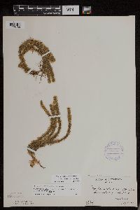 Huperzia selago (L.) Bernhardi ex Schrank & Martius 357393[1295180]Butters, F.K. 3761937-07-11 United States, Minnesota, Cook, South side of Lucile Island [Susie Islands, The Nature Conservancy Preserve; T63N;R7E], 47.973776 -89.578978 |
MIN:Plants | 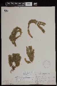 Huperzia selago (L.) Bernhardi ex Schrank & Martius 357397[1295179]Butters, F.K. 1111938-07-11 United States, Minnesota, Cook, South side of Rove Lake [Boundary Waters Canoe Area Wilderness / Superior National Forest; T65N;R1E], 48.092221 -90.37664 |
MIN:Plants | 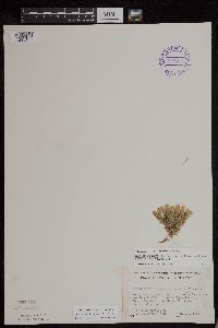 Huperzia selago (L.) Bernhardi ex Schrank & Martius 393214[1295163]Ownbey, Gerald B. 10671948-08-14 United States, Minnesota, Cook, Northwest side of Belle Rose Island, Susie Islands near Grand Portage [Susie Islands, The Nature Conservancy Preserve], 47.973776 -89.578978 |
MIN:Plants |  Huperzia selago (L.) Bernhardi ex Schrank & Martius 393240[1295178]Ownbey, Gerald B. 11151948-08-16 United States, Minnesota, Cook, About midcenter of Long Island, Susie Islands near Grand Portage [Susie Islands, The Nature Conservancy Preserve], 47.975384 -89.603101 |
MIN:Plants | 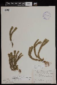 Huperzia selago (L.) Bernhardi ex Schrank & Martius 393250[1295165]Ownbey, Gerald B. 983b1948-08-11 United States, Minnesota, Cook, About 1 mi NE of Cook Co. line, Hwy. #61 [Finland State Forest; T58N;R5W], 47.773356 -90.383836 |
MIN:Plants | 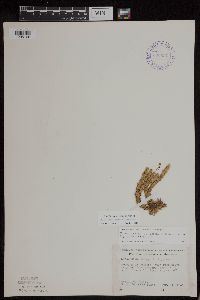 Huperzia selago (L.) Bernhardi ex Schrank & Martius 393251[1295166]Ownbey, Gerald B. 983a1948-08-11 United States, Minnesota, Cook, About 1 mi NE of Cook Co. line, Hwy. #61 [Finland State Forest; T58N;R5W], 47.773356 -90.383836 |
MIN:Plants | 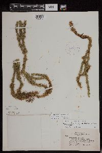 Huperzia selago (L.) Bernhardi ex Schrank & Martius 407307[1295149]Lakela, Olga 92351949-08-06 United States, Minnesota, Saint Louis, Lake Everett, Echo Trail, N of Ely [T64N;R12W], 48.116014 -92.14764 |
MIN:Plants | 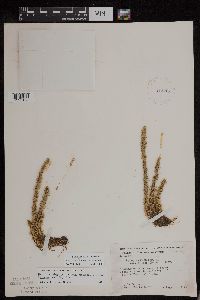 Huperzia selago (L.) Bernhardi ex Schrank & Martius 412252[1295168]Moore, John W. 118741939-08-18 United States, Minnesota, Koochiching, Along the south east shore of Tilson Bay, Rainy Lake [T71N;R23W], 48.606604 -93.401815 |
MIN:Plants | 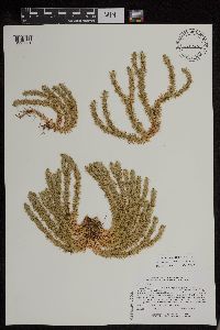 Huperzia selago (L.) Bernhardi ex Schrank & Martius 441766[1295031]Lee, Michael D. MDL15561996-09-11 United States, Minnesota, Carlton, north-facing cliff along the St. Louis River gorge immediately downstream from the Thomson dam, just above Carlton Co.; north-facing cliff along the St. Louis River gorge immediately downstream from the Thomson dam, just above the HWY 210 bridge; T48N R16W SE1/4 SE1/4 Sec. 6, NE1/4 NE1/4 Sec. 7, 46.663361 -92.425737 |
MIN:Plants |  Huperzia selago (L.) Bernhardi ex Schrank & Martius 516101[1295027]Myhre, K.M. 40281993-07-05 United States, Minnesota, Pine, Located 2 mi NE of the town of Sandstone, along a W-facing sandstone escarpment of the Kettle River. T43N R20W NW1/4 of SE1/4 of Sec 35. [Banning State Park], 46.164078 -92.834671 |
MIN:Plants |  Huperzia selago (L.) Bernhardi ex Schrank & Martius 529040[1295177]Lakela, Olga 206491956-08-09 United States, Minnesota, Saint Louis, Gun Lake near Bullet Lake portage, Superior National Forest N of Ely [Boundary Waters Canoe Area Wilderness], 48.114633 -91.831223 |
MIN:Plants |  Huperzia selago (L.) Bernhardi ex Schrank & Martius 543159[1295176]Lakela, Olga 22467a1957-09-13 United States, Minnesota, Lake, Snow Bank Lake [Boundary Waters Canoe Area Wilderness / Superior National Forest], 47.98294 -91.462295 |
MIN:Plants |  Huperzia selago (L.) Bernhardi ex Schrank & Martius 561052[1295171]Ownbey, Gerald B. 2698b1959-06-21 United States, Minnesota, Clearwater, NW1/4 sec.23, T143N, R37W, 1.9 mi W of W boundary of Itasca Park, along forest access road, 47.190765 -95.333918 |
MIN:Plants | 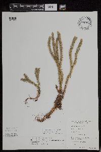 Huperzia selago (L.) Bernhardi ex Schrank & Martius 702024[1295170]Sather, Nancy 4131977-06-20 United States, Minnesota, Saint Louis, Plot G31; SE1/4, SE1/4: T60N R12W S12 [Superior National Forest], 47.695047 -91.807277 |
MIN:Plants | 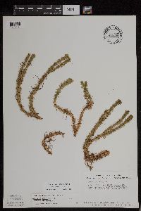 Huperzia selago (L.) Bernhardi ex Schrank & Martius 724512[1295161]Smith, Welby R. 30971980-07-29 United States, Minnesota, Saint Louis, T62N R13W, SE1/4 NW1/4 NW1/4 sec.33; banks of the Beaver River [Bear Island State Forest], 47.809161 -91.996897 |
MIN:Plants | 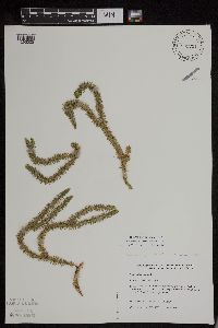 Huperzia selago (L.) Bernhardi ex Schrank & Martius 831791[1295025]Boe, Janet 920608011992-06-08 United States, Minnesota, Roseau, Beltrami Island State Forest; just W of Wabble Grade Forest Road; NE1/4 NE1/4 Sec.26 T161N R37W, 48.734613 -95.385109 |
MIN:Plants | 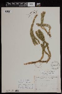 Huperzia selago (L.) Bernhardi ex Schrank & Martius 525871[1295174]Lakela, Olga 187981955-07-12 United States, Minnesota, Saint Louis, south of Gilbert [T58N;R17W], 47.488816 -92.464905 |
MIN:Plants |  Huperzia selago (L.) Bernhardi ex Schrank & Martius 55415[1295218]Sandberg, J.H. s.n.1893-08-00 United States, Washington, Stevens Pass, 1219 - 1829m |
MIN:Plants |  Huperzia selago (L.) Bernhardi ex Schrank & Martius 599840[1295203]Cooper, William S. 2171916-08-28 United States, Alaska, Glacier Bay, Station 22 [Glacier Bay National Park], 58.797428 -136.838127 |
MIN:Plants |  Huperzia selago (L.) Bernhardi ex Schrank & Martius 477217[1295026]Gerdes, Lynden B. 41442000-07-25 United States, Minnesota, Lake, T57N R07W S35NWSW. Wolf Ridge Environmental Learning Center, Finland, MN. Cliff feature on the south side of Wolf Lake., 47.379057 -91.182368 |
MIN:Plants |  Huperzia selago (L.) Bernhardi ex Schrank & Martius 431700[1295190]Dahle, Rolf M. 010332001-09-05 United States, Minnesota, Itasca, In a taconite tailings basin about a mile southwest of the town of Taconite. T56 R24 NW1/4 of NW1/4 of Sec 34, 47.293889 -93.38 |
MIN:Plants |  Huperzia selago (L.) Bernhardi ex Schrank & Martius 436016[1295173]Dahle, Rolf M. 200152000-08-02 United States, Minnesota, Itasca, In a taconite tailings basin just south of the village of Holman. T 56 R 24 SE1/4 of SW1/4 of Sec 26, 47.299444 -93.353333 |
MIN:Plants |  Huperzia selago (L.) Bernhardi ex Schrank & Martius 505472[1295152]Carlson, Bruce W. Wypt 5032004-08-25 United States, Minnesota, Saint Louis, 0.25 miles east of St. Louis County Rd 266, 0.6 miles south of Chris Lake, 0.1 miles north of the West Branch Knife River. DNR Releve 3508. T054N R12W SWNE 35 [Cloquet Valley State Forest], 47.589862 -92.456101 |
Google Map
Google Maps is a web mapping service provided by Google that features a map that users can pan (by dragging the mouse) and zoom (by using the mouse wheel). Collection points are displayed as colored markers that when clicked on, displays the full information for that collection. When multiple species are queried (separated by semi-colons), different colored markers denote each individual species.