University of Minnesota
http://www.umn.edu/
612-625-5000
http://www.umn.edu/
612-625-5000
Minnesota Biodiversity Atlas
Bell Museum
Dataset: MIN-Plants
Taxa: Brassicaceae
Search Criteria: excluding cultivated/captive occurrences
Bell Museum plants | |
 MIN:Plants | Cardamine purpurea Chamisso & Schlechtendal 601073[]Munns, C. 4851966-06-29 United States, Alaska, Primrose Ridge in McKinley National Park;Denali National Park |
MIN:Plants | Draba breweri S. Watson 234149[]Congdon, J. s.n.1895-08-27 United States, California, Tuolumne, Mt. Dana, Tuolumne County;Yosemite National Park;;;, 37.8999 -119.2211 |
MIN:Plants | Draba breweri S. Watson 234155[]Congdon, J. s.n.1898-08-10 United States, California, Tuolumne, Mt. Dana, Tuolumne County;Yosemite National Park;;;, 37.8999 -119.2211 |
MIN:Plants | Draba breweri S. Watson 234150[]Congdon, J. s.n.1894-08-21 United States, California, Tuolumne, Mt. Warren Trail, Tuolumne County;Yosemite National Park |
MIN:Plants | Draba breweri S. Watson 234153[]Congdon, J. s.n.1898-08-10 United States, California, Tuolumne, Mt. Dana, Tuolumne County;Yosemite National Park;;;, 37.8999 -119.2211 |
MIN:Plants | Strigosella africana (L.) Botschantzev 794620[]Schaaf, J. 1151983-06-23 United States, Nevada, White Pine, White Pine County ... Alt. US 93, WP-MP-92-12, 1859m |
MIN:Plants | Lepidium lasiocarpum Nuttall 499396[]Went, F. s.n.1952-04-19 United States, California, Imperial, Salton Sea, Imperial Co. |
MIN:Plants |  Rorippa officinale (R. Brown) P. Royen 234066[1181792]Congdon, J. s.n.1887-06-06 United States, California, Mariposa, Footman Mt.;Yosemite National Park;;;, 37.54549 -119.82489 |
MIN:Plants |  Rorippa officinale (R. Brown) P. Royen 794622[1181791]Schaaf, J. 1091982-08-03 United States, Nevada, Pershing, Pershing Co. ... Humboldt Range, Limerick Canyon ... Elev.: 5600 ft. |
MIN:Plants | Rorippa officinale (R. Brown) P. Royen 453013[]Bright, R. 72-211972-00-00 United States, Idaho, Franklin, [no further data] |
MIN:Plants |  456211[1352548]Beaudry, S. 202005-10-07 United States, Minnesota, Hennepin, Hennepin County...Long Lake Park reserve SE1/4 NW1/4 Sec.35 T 117 R22.;Long Lake County Park;117N;22W;35, 44.89894 -93.431977 |
MIN:Plants | 609648[]Pollard, Henry s.n.1967-08-05 United States, California, Ventura, at Foster Park, Ventura County, Ventura |
MIN:Plants |  456213[1181107]Elakkad, Amar 332005-10-02 United States, Minnesota, Ramsey, University of Minnesota Agriculture Experiment Station field K1. NE1/4 NW1/4 ;;029N;23W;21, 44.984523 -93.177092 |
MIN:Plants |  Rorippa sylvestris (L.) Besser 499381[1134698]Capistrant, A. AMC13271998-06-23 United States, Minnesota, Carver, [no further data];;116N;23W;16, 44.855973 -93.592079 |
MIN:Plants |  Rorippa sylvestris (L.) Besser 829119[1183272]Chick, Drew s.n.1929-08-13 United States, Washington, Pierce, Mount Rainier National Park, at start of Nisqually Glacier Trail;Mount Rainier National Park |
MIN:Plants |  Rorippa sylvestris (L.) Besser 455143[1134699]Dziuk, P. s.n.2002-09-12 United States, Minnesota, Hennepin, Hennepin Co, Minneapolis, Bahman's Nursery, growing area.;;117N;24W;, 44.934498 -93.706443 |
MIN:Plants |  Rorippa sylvestris (L.) Besser 491021[1134697]Capistrant, A. AMC15341998-08-05 United States, Minnesota, Carver, [no further data];;116N;23W;16, 44.855973 -93.592079 |
MIN:Plants | 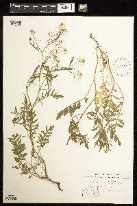 Rorippa sylvestris (L.) Besser 572957[1183273]Stevens, O. 25941962-07-17 United States, North Dakota, Cass, Fargo, Cass Co. |
MIN:Plants | 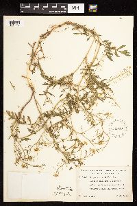 Rorippa sylvestris (L.) Besser 529010[1134701]Lakela, Olga 187491955-07-06 United States, Minnesota, Saint Louis, Edge of parking lot, at Alworth Place, UMD [Univ. of Minn.] Campus, Duluth.;;050N;14W;14, 46.814884 -92.079219 |
MIN:Plants |  Rorippa sylvestris (L.) Besser 532393[1134702]Lakela, Olga 202751956-07-05 United States, Minnesota, Saint Louis, Arboretum grounds at Fond du Lac, Duluth.;;N;;, 46.659664 -92.273248 |
MIN:Plants | 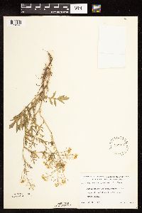 Rorippa sylvestris (L.) Besser 533017[1134700]Lakela, Olga 204461956-07-13 United States, Minnesota, Saint Louis, University of Minnesota, Duluth branch.;;N;;, 46.814884 -92.079219 |
MIN:Plants | 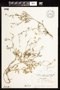 Rorippa sylvestris (L.) Besser 696544[1134695]Smith, Welby 7621978-07-06 United States, Minnesota, Wright, Wright County...T122N, R26W, N1/2 Sec. 7. About 2 mi. SE. of Clearwater. On a bank of the Mississippi [River].;;122N;26W;07, 45.390467 -94.00344 |
MIN:Plants | 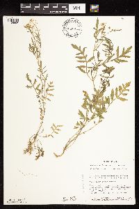 Rorippa sylvestris (L.) Besser 804450[1134696]Smith, Welby 108261985-07-21 United States, Minnesota, Ramsey, Ramsey County...Beach of the Mississippi River, on the N side of the St. Paul Downtown Airport (Holman Field). sec. 4, T 28N R 22W. 028N 22W 4, 44.941358 -93.055503 |
MIN:Plants | 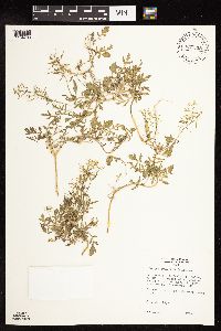 Rorippa sylvestris (L.) Besser 835398[1134703]Monson, Paul 50111974-07-24 United States, Wisconsin, Buffalo, Buffalo Co. R-13W, T-22N. Mississippi R. ...adjacent to river channel SE of Wabasha, MN |
MIN:Plants | 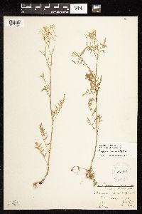 Rorippa sylvestris (L.) Besser 269119[1134704]Wilson, L. 42521927-08-29 United States, Wisconsin, Pierce, Pierce Co. ...Bay City |
MIN:Plants | 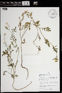 Rorippa sylvestris (L.) Besser 971281[1394758]M. H. Nee 659002020-07-05 United States, Wisconsin, Crawford, Fishing area on Wisconsin River below Hwy. 60/61, just S of junction with Hwy. 60. T 8 N; R 3 W; SW¼ SW¼ sect. 14, 43.165556 -90.704167, 200m |
MIN:Plants |  Rorippa sylvestris (L.) Besser 972685[1398238]Blytt s.n. Norway |
MIN:Plants | Physaria brassicoides Rydberg 501563[]Stevens, O. 14761954-05-29 United States, North Dakota, Billings, Theodore Roosevelt National Memorial Park;Theodore Roosevelt National Park |
MIN:Plants | Lepidium densiflorum Schrader 915013[]Smith, Welby 226531993-07-01 United States, Minnesota, Otter Tail, Inspiration Peak Scenic Wayside Park. Otter Tail County ... Inspiration Peak State Wayside Park, about 12 miles west of Parkers Prairie ... T131N R39W SE1/4 of SW1/4 of Sec 22. 131N 39W 22, 46.1383333 -95.5736111 |
MIN:Plants |  Lepidium densiflorum Schrader 488821[1356031]Gerdes, Lynden; et al. 35421999-06-29 United States, Minnesota, Cook, T65N R01W S28SE Cook County ... Superior National Forest, Duncan Lake, BWCAW... Near tip of peninsula.;Boundary Waters Canoe Area Wilderness / Superior National Forest;065N;01W;28, 48.085413 -90.462089 |
MIN:Plants | Lepidium densiflorum Schrader 910860[]Smith, Welby 219171992-09-03 United States, Minnesota, Watonwan, Watonwan County...At the east end of St. James Lake, just southwest of the town of St. James...T 106N R 32W SW1/4 of NE1/4 of Sec 23. 106N 32W 23, 43.975 -94.6430556 |
MIN:Plants | Lepidium densiflorum Schrader 681465[]Swanson, Steven 8681975-06-24 United States, Wisconsin, La Crosse, Mississippi River (Navigation Pool #8)...La Crosse Co, Site 27...island along the main channel;Upper Mississippi National Wildlife Refuge |
MIN:Plants | Lepidium densiflorum Schrader 500169[]Wheeler, Gerald 191511998-06-15 United States, Minnesota, Scott, Minnesota Valley State Park. Scott County ... Ca. 4.5 mi. NNE of Jordan; 1.2 mi. W of Rte. 169. Louisville Swamp; Carver Rapids Wayside ... SE1/4 NE1/4 NW1/4 Sec. 32 T115N R23W (Louisville 32). 115N 23W 32, 44.725535 -93.612653 |
MIN:Plants | Lepidium densiflorum Schrader 539996[]Tester, John s.n.1957-06-26 United States, Minnesota, Mahnomen, Mahnomen County...Waubun prairie, 3-4 miles w. and 1 mile s. of Waubun. Sect. 33, T. 143N, R. 42W.;Waubun Prairie Wildlife Management Area / White Earth Indian Reservation;143N;42W;33, 47.158904 -96.00743 |
MIN:Plants | Lepidium densiflorum Schrader 492345[]Capistrant, A. AMC13571998-05-11 United States, Minnesota, Ramsey, [no further data];;029N;22W;21, 44.9847716 -93.0559436 |
MIN:Plants | Lepidium densiflorum Schrader 918225[]Smith, Welby 223671993-06-08 United States, Minnesota, Carver, Carver County...Carver Park Reserve; about 5 miles west of Chanhassen...T 116N R 24W SE1/4 of NE1/4 of Sec 11;Carver Park Reserve County Park;116N;24W;11, 44.8716667 -93.6644444 |
MIN:Plants | Lepidium densiflorum Schrader 226920[]Moyer, Lycurgus s.n.1912-07-02 United States, South Dakota, Grant, Big Stone City |
MIN:Plants | Lepidium densiflorum Schrader 570739[]Wheeler, Gerald 160091997-06-08 United States, Minnesota, Nicollet, Swan Lake Wildlife Management Area. Nicollet County ... Ca. 4 mi. SSW of Nicollet on Rte. 23; Swan Lake State WMA, North Star Unit ... N1/2 SE1/4 NW1/4 Sec. 28 T109N R28W (Nicollet 28). 109N 28W 28, 44.217999 -94.200153 |
MIN:Plants | Lepidium densiflorum Schrader 452970[]Wheeler, Gerald 194531998-06-25 United States, Minnesota, Sibley, Sibley Co.; Ca. 8.5 mi. ESE of Green Isle, 4.5 mi. WSW of the jct. of Rte. 6 and Rte. 25, N of road (Rte. 6); N1/2 NE1/4 Sec. 5 T113N R25w. 113N 25W 5, 44.618979 -93.852531 |
MIN:Plants | Lepidium densiflorum Schrader 896818[]Haferman, J. 2071996-06-15 United States, Minnesota, Scott, Approx. 0.1 miles NNE of intersection of State Highway 13 and County Road 44 on N side of highway. SW1/4 of SW1/4 of section.;;115N;22W;36, 44.72459 -93.40903 |
MIN:Plants | Lepidium densiflorum Schrader 904853[]BioBlitz volunteers s.n.2008-06-14 United States, Minnesota, Carver, Rapids Lake Unit, west side of Minnesota River. ;Minnesota Valley National Wildlife Refuge;114N;23W;06, 44.710544 -93.63374 |
MIN:Plants | Lepidium densiflorum Schrader 511504[]Wheeler, Gerald 164991997-07-01 United States, Minnesota, Yellow Medicine, Yellow Medicine County ... Ca. 5 mi. NE of Echo ... SE1/4 SE1/4 Sec. 12 T114N R38W (Sioux Agency 12);Swedes Forest Scientific Natural Area;114N;38W;12, 44.694087 -95.370736 |
MIN:Plants | Lepidium densiflorum Schrader 575539[]Garton, C. 85181961-07-01 Canada, Ontario, Rainy River, Rainy River District...1 mi. W. of Rainy River V, Rainy River, Atwood Twp. |
MIN:Plants | Lepidium densiflorum Schrader 453017[]Univ. of Minn. Agronomy 196 United States, [no data] |
MIN:Plants | Lepidium densiflorum Schrader 119965[]Nelson, Aven; et al. 57451899-07-19 United States, Wyoming, Park, Yellowstone National Park...Yellowstone River;Yellowstone National Park |
MIN:Plants | Lepidium densiflorum Schrader 492061[]Scott, P. 12512000-07-12 United States, Minnesota, Cook, Cook Co ... near east end of Clearwater Lake, BWCAW ... T65N R1E sec.25 SESENW.;Boundary Waters Canoe Area Wilderness / Superior National Forest;065N;01E;25, 48.084883 -90.266093 |
MIN:Plants | Lepidium densiflorum Schrader 295309[]Benner, F.; Benner, J. 1691928-08-02 United States, Wisconsin, Polk, 7 mi N. St. Croix Falls, Wis. on River Road;Saint Croix National Riverway;;;, 45.481172 -92.687024 |
MIN:Plants | Lepidium densiflorum Schrader 699720[]Ziegler, S.; et al. 19451975-07-22 United States, Wisconsin, La Crosse, LaCrosse Co.; Island 21...Mississippi River-mile #695...T15N R7W Sec 17...island E side of main channel;Upper Mississippi National Wildlife Refuge;015N;07W;17, 194m |
MIN:Plants | Lepidium densiflorum Schrader 119681[]Rosendahl, C. 3171902-06-04 United States, Minnesota, Houston, Spring Grove;;101N;07W;, 43.543923 -91.6707 |
MIN:Plants | Lepidium densiflorum Schrader 119682[]Ballard, C. 28051901-06-04 United States, Minnesota, Clay, Moorhead;;N;;, 46.845648 -96.728846 |
MIN:Plants | Lepidium densiflorum Schrader 119705[]Arthur, J.; et al. B5241886-07-29 United States, Minnesota, Lake, Agate Bay;North Shore;052N;11W;01, 47.01954 -91.67918 |
MIN:Plants | Lepidium densiflorum Schrader 119706[]MacMillan, C.; et al. MS11701894-07-00 United States, Minnesota, Lake of the Woods, Oak Point;Pine & Curry Islands Scientific Natural Area;162N;31W;06, 48.87976 -94.69025 |
MIN:Plants | Lepidium densiflorum Schrader 119707[]Skinner, S. 131902-06-09 United States, Minnesota, Jackson, Heron Lake Region;;N;;, 43.760874 -95.255356 |
MIN:Plants | Lepidium densiflorum Schrader 119708[]Sheldon, Edmund s.n.1895-06-00 United States, Minnesota, Hennepin, Minneapolis;;N;;, 44.979965 -93.263836 |
MIN:Plants | Lepidium densiflorum Schrader 119709[]Sandberg, John s.n.1881-05-00 United States, Minnesota, Goodhue, Cannon Falls;;N;;, 44.49989 -92.85476 |
MIN:Plants | Lepidium densiflorum Schrader 119710[]Lyon, H. 1231899-06-17 United States, Minnesota, Houston, Winnebago Valley, Houston Co.;Dorer Memorial Hardwood State Forest;N;;, 43.53967 -91.40968 |
MIN:Plants | Lepidium densiflorum Schrader 119711[]Menzel, Max s.n.1895-06-00 United States, Minnesota, Pipestone, Pipestone [assuming the quarry area; town generally noted as Pipestone City by collector];Pipestone National Monument;106N;46W;01, 44.015848 -96.317669 |
MIN:Plants | Lepidium densiflorum Schrader 119712[]Sheldon, Edmund S30931892-07-00 United States, Minnesota, Mille Lacs, Princeton;;036N;26W;, 45.602777 -93.573848 |
MIN:Plants | Lepidium densiflorum Schrader 119713[]Frost, W. F1051892-06-00 United States, Minnesota, Meeker, Litchfield;;N;;, 45.127185 -94.528047 |
MIN:Plants | Lepidium densiflorum Schrader 119714[]Sheldon, Edmund s.n.1895-06-00 United States, Minnesota, Hennepin, Minneapolis;;N;;, 44.979965 -93.263836 |
MIN:Plants | Lepidium densiflorum Schrader 119715[]Sheldon, Edmund S611891-06-00 United States, Minnesota, Le Sueur, Elysian;;109N;24W;, 44.239498 -93.707142 |
MIN:Plants | Lepidium densiflorum Schrader 119716[]Oestlund, O. s.n.1886-06-04 United States, Minnesota, Hennepin, [no further data];;;;, 45 -93.47 |
MIN:Plants | Lepidium densiflorum Schrader 119717[]Sandberg, John s.n.1890-07-00 United States, Minnesota, Hennepin, [no further data];;;;, 45 -93.47 |
MIN:Plants | Lepidium densiflorum Schrader 119718[]Kassube, J. s.n.1878-05-00 United States, Minnesota, Hennepin, Minneapolis;;N;;, 44.979965 -93.263836 |
MIN:Plants | Lepidium densiflorum Schrader 119719[]Sheldon, Edmund S32071892-07-00 United States, Minnesota, Mille Lacs, Milaca;;037N;27W;, 45.692047 -93.698793 |
MIN:Plants | Lepidium densiflorum Schrader 119720[]Herrick, C. s.n.1877-06-08 United States, Minnesota, Hennepin, Minneapolis;;N;;, 44.979965 -93.263836 |
MIN:Plants | Lepidium densiflorum Schrader 119721[]Holzinger, John s.n.1886-06-00 United States, Minnesota, Winona, Winona Co.;;N;;, 43.926613 -91.67387 |
MIN:Plants | Lepidium densiflorum Schrader 119722[]Taylor, B. T1901891-06-00 United States, Minnesota, Waseca, Janesville;;N;;, 44.116078 -93.708004 |
MIN:Plants | Lepidium densiflorum Schrader 119723[]Sheldon, Edmund S29381892-07-00 United States, Minnesota, Mille Lacs, Milaca;;N;;, 45.755204 -93.648713 |
MIN:Plants | Lepidium densiflorum Schrader 119724[]Manning, Sara s.n.1884-07-07 United States, Minnesota, Wabasha, Lake City;;N;;, 44.44402 -92.273367 |
MIN:Plants | Lepidium densiflorum Schrader 119725[]Moyer, Lycurgus s.n.1892-06-12 United States, Minnesota, Chippewa, Rock Cut, Montevideo.;;117N;40W;, 44.934626 -95.675774 |
MIN:Plants | Lepidium densiflorum Schrader 119726[]Moyer, Lycurgus s.n.1910-10-19 United States, Minnesota, Mille Lacs, Mille Lacs Co.;;;;, 45.938041 -93.630083 |
MIN:Plants | Lepidium densiflorum Schrader 119727[]Moyer, Lycurgus s.n.1885-06-00 United States, Minnesota, Chippewa, Montevideo;;117N;40W;, 44.934626 -95.675774 |
MIN:Plants | Lepidium densiflorum Schrader 119728[]Menzel, Max s.n.1895-05-00 United States, Minnesota, Pipestone, Pipestone [assuming the quarry area; town generally noted as Pipestone City by collector];Pipestone National Monument;106N;46W;01, 44.015848 -96.317669 |
MIN:Plants | Lepidium densiflorum Schrader 119739[]Arthur, J.; et al. B1321886-07-20 United States, Minnesota, Saint Louis, Vermilion Lake;;;;, 47.891581 -92.366824 |
MIN:Plants | Lepidium densiflorum Schrader 119838[]Moyer, Lycurgus 16881893-07-09 United States, Minnesota, Chippewa, Montevideo;;117N;40W;, 44.934626 -95.675774 |
MIN:Plants | Lepidium densiflorum Schrader 119969[]Aiton, G. 16861902-05-24 United States, Minnesota, Olmsted, Rochester;;106N;14W;00, 43.97834 -92.498342 |
MIN:Plants | Lepidium densiflorum Schrader 225525[]Butters, F.; et al. 40751921-06-19 United States, Minnesota, Wilkin, Red River Valley, E of Breckenridge.;;;;, 46.265706 -96.562723 |
MIN:Plants | Lepidium densiflorum Schrader 225548[]Rosendahl, C.; Butters, F. 45291924-07-01 United States, Minnesota, Cook, Cook Co.; Mouth of the Brule River.;Judge Magney State Park / North Shore;062N;03E;, 47.849836 -90.064949 |
MIN:Plants | Lepidium densiflorum Schrader 225549[]Rosendahl, C.; Butters, F. 45381924-07-02 United States, Minnesota, Cook, Cook Co.; Mouth of the Brule River.;Judge Magney State Park / North Shore;062N;03E;, 47.849836 -90.064949 |
MIN:Plants | Lepidium densiflorum Schrader 276114[]Moyle, J. 181930-06-29 United States, Minnesota, Clearwater, Itasca Park. Near campus. SE1/4 SE1/4 Sec. 2, T143N, R36W.;Itasca State Park;143N;36W;2, 47.231973 -95.201528 |
MIN:Plants | Lepidium densiflorum Schrader 337027[]Lakela, Olga 14521936-06-30 United States, Minnesota, Saint Louis, Along Minnesota Avenue at 40th St, Duluth.;;N;;, 46.741215 -92.062388 |
MIN:Plants | Lepidium densiflorum Schrader 349064[]Rosendahl, C.; et al. 30251935-05-19 United States, Minnesota, Pipestone, Near Pipestone. Pipestone Co.;;106N;46W;, 43.979723 -96.367859 |
MIN:Plants | Lepidium densiflorum Schrader 349654[]Hedman, H. 821938-07-00 United States, Minnesota, Hennepin, Minnetonka shore near Arcola;;N;;, 44.94009 -93.58493 |
MIN:Plants | Lepidium densiflorum Schrader 349794[]Nielsen, E. 20881933-07-05 United States, Minnesota, Becker, Near Camp Showandassee, on Long Lake, near Detroit Lakes.;;N;;, 46.81886 -95.89399 |
MIN:Plants | Lepidium densiflorum Schrader 367103[]Moore, John; Moore, Marjorie 101891938-06-26 United States, Minnesota, Dakota, 1/4 mi w of Fifth ave and just s of Church St, South St. Paul.;;028N;22W;, 44.905226 -93.045075 |
MIN:Plants | Lepidium densiflorum Schrader 370234[]Moore, John; et al. 141771941-06-10 United States, Minnesota, Wilkin, Wilkin County...Along a r.r. right-of-way; SE1/4 Sec. 26, Champion Twp.;;130N;45W;26, 46.043255 -96.297069 |
MIN:Plants | Lepidium densiflorum Schrader 381498[]Moore, John; et al. 153971942-06-20 United States, Minnesota, Olmsted, 1 mi n of Rochester, on hwy 63. Olmsted Co.;;;;, 44.036114 -92.469899 |
MIN:Plants | Lepidium densiflorum Schrader 381744[]Moore, John; et al. 153131942-06-19 United States, Minnesota, Steele, Straight River, bridge at n end of Medford, Medford Twp, NE1/4 sec.8. Steele Co.;;108N;20W;08, 44.175058 -93.256678 |
MIN:Plants | Lepidium densiflorum Schrader 385499[]Rosendahl, C. 77401945-09-15 United States, Minnesota, Houston, West Beaver Spring, Sec.17 Caledonia Twp.;Beaver Creek Valley State Park;102N;06W;17, 43.637879 -91.581102 |
MIN:Plants | Lepidium densiflorum Schrader 386228[]Lakela, Olga 30161939-06-24 United States, Minnesota, Saint Louis, Near the dock, Sec. 20, Minnesota Point.;Minnesota Point;049N;13W;20, 46.741215 -92.062388 |
MIN:Plants | Lepidium densiflorum Schrader 394092[]Butters, F.; Abbe, E. 8441944-08-01 United States, Minnesota, Cook, back of an old burned down lodge across the bay from Camp Rockwood, Poplar Lake; T64N R2W.;Superior National Forest;064N;02W;, 48.019752 -90.574838 |
MIN:Plants | Lepidium densiflorum Schrader 412468[]Moore, John; Moore, Marjorie 113681939-08-02 United States, Minnesota, Roseau, 1.3 mi. N of Longworth, elev. 1072 ft.;;N;;, 49.001303 -95.364961 |
MIN:Plants | Lepidium densiflorum Schrader 419065[]Ahlgren, Clifford 1561949-07-09 United States, Minnesota, Lake, Quetico-Superior Wilderness Research Center...Lake Co. T64N R10W;Boundary Waters Canoe Area Wilderness / Superior National Forest;064N;10W;09, 48.031651 -91.618862 |
MIN:Plants | Lepidium densiflorum Schrader 421010[]Lakela, Olga 107881950-07-24 United States, Minnesota, Saint Louis, Pequaywan Lakes, s of Rollins;Cloquet Valley State Forest;N;;, 47.145557 -91.91488 |
MIN:Plants |  Lepidium densiflorum Schrader 428197[1356028]Nation, R. 94-1571994-06-21 United States, Minnesota, Mower, Lake Louise State Park. Mower Co.; Tract #22B. T101N R14W N1/2 NE1/4 of sec.21;Lake Louise State Park;101N;14W;21, 43.536578 -92.519043 |
MIN:Plants | Lepidium densiflorum Schrader 430058[]Smith, Welby 152991989-06-05 United States, Minnesota, Chisago, Wild River State Park. Chisago County...St. Croix Wild River State Park, about 9 miles north-northwest of Taylors Falls...SE1/4 NW1/4 section 17, T 35N R 19W. 035N 19W 17, 45.523056 -92.7486115 |
MIN:Plants |  Lepidium densiflorum Schrader 430132[1356029]Haferman, J. 1261995-07-01 United States, Minnesota, Scott, Scott Co. T115N R22W S36 SW of SW. Approx. 0.1 mi N-NE of intersection of State Hwy.13 and Co. Road 44 on N side of high Scott Co. T115N R22W S36 SW of SW. Approx. 0.1 mi N-NE of intersection of State Hwy.13 and Co. Road 44 on N side of highway.. 115N 22W 36, 44.724586 -93.409031 |
MIN:Plants | 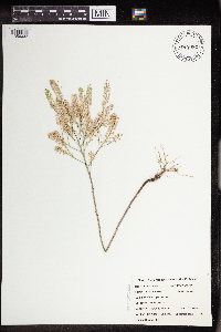 Lepidium densiflorum Schrader 434982[1356032]Hanson, Catherine 691999-07-16 United States, Minnesota, Morrison, Crane Meadows National Wildlife Refuge; NWSE 30-40-31;Crane Meadows National Wildlife Refuge;040N;31W;30, 45.933896 -94.251564 |
MIN:Plants | 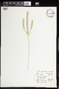 Lepidium densiflorum Schrader 434992[1356033]Belanger, W. 2451999-07-15 United States, Minnesota, Morrison, Crane Meadows National Wildlife Refuge; SWSE 30-40-31;Crane Meadows National Wildlife Refuge;040N;31W;30, 45.933896 -94.251564 |
Google Map
Google Maps is a web mapping service provided by Google that features a map that users can pan (by dragging the mouse) and zoom (by using the mouse wheel). Collection points are displayed as colored markers that when clicked on, displays the full information for that collection. When multiple species are queried (separated by semi-colons), different colored markers denote each individual species.