University of Minnesota
http://www.umn.edu/
612-625-5000
http://www.umn.edu/
612-625-5000
Minnesota Biodiversity Atlas
Bell Museum
Dataset: MIN-Plants
Taxa: Brassicaceae
Search Criteria: excluding cultivated/captive occurrences
Bell Museum plants | |
 MIN:Plants | Lepidium densiflorum Schrader 430058[]Smith, Welby 152991989-06-05 United States, Minnesota, Chisago, Wild River State Park. Chisago County...St. Croix Wild River State Park, about 9 miles north-northwest of Taylors Falls...SE1/4 NW1/4 section 17, T 35N R 19W. 035N 19W 17, 45.523056 -92.7486115 |
MIN:Plants | 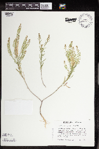 Lepidium densiflorum Schrader 430132[1356029]Haferman, J. 1261995-07-01 United States, Minnesota, Scott, Scott Co. T115N R22W S36 SW of SW. Approx. 0.1 mi N-NE of intersection of State Hwy.13 and Co. Road 44 on N side of high Scott Co. T115N R22W S36 SW of SW. Approx. 0.1 mi N-NE of intersection of State Hwy.13 and Co. Road 44 on N side of highway.. 115N 22W 36, 44.724586 -93.409031 |
MIN:Plants | 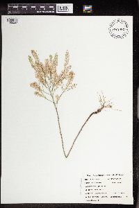 Lepidium densiflorum Schrader 434982[1356032]Hanson, Catherine 691999-07-16 United States, Minnesota, Morrison, Crane Meadows National Wildlife Refuge; NWSE 30-40-31;Crane Meadows National Wildlife Refuge;040N;31W;30, 45.933896 -94.251564 |
MIN:Plants | 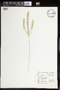 Lepidium densiflorum Schrader 434992[1356033]Belanger, W. 2451999-07-15 United States, Minnesota, Morrison, Crane Meadows National Wildlife Refuge; SWSE 30-40-31;Crane Meadows National Wildlife Refuge;040N;31W;30, 45.933896 -94.251564 |
MIN:Plants | Lepidium densiflorum Schrader 437000[]Moore, John; Hall, Robert 162411944-06-07 United States, Minnesota, Blue Earth, 3 1/2 mi. W of Mankato;;N;;, 44.163556 -94.070065 |
MIN:Plants | Lepidium densiflorum Schrader 437011[]Moore, John; Hall, Robert 162981944-06-08 United States, Minnesota, Nobles, Along Rock Island right-of-way, 1 mi. N of Worthington.;;N;;, 43.634449 -95.596398 |
MIN:Plants | Lepidium densiflorum Schrader 437308[]Moore, John; Hall, Robert 165461944-06-13 United States, Minnesota, Redwood, 1 mi E of Walnut Grove on hwy 14, Redwood Co.;;109N;38W;, 44.239355 -95.41137 |
MIN:Plants | Lepidium densiflorum Schrader 437459[]Moore, John; Hall, Robert 165801944-06-13 United States, Minnesota, Cottonwood, Red Rock Dells, S of Sanborn.;;N;;, 44.123013 -95.102214 |
MIN:Plants | Lepidium densiflorum Schrader 437461[]Moore, John; Hall, Robert 165851944-06-14 United States, Minnesota, Renville, Hwy. 19 at Morton, near bridge. Renville Co.;;113N;34W;, 44.585501 -94.934085 |
MIN:Plants | Lepidium densiflorum Schrader 440185[]Myhre, K. 40641993-07-07 United States, Minnesota, Pine, Pine Co. Located 2.5 mi E of the town of Duxbury. Plants occur in a gravel pit; T42N R17W NE1/4 of NE1/4 of Sec 14;Saint Croix State Forest;042N;17W;14, 46.120445 -92.456627 |
MIN:Plants | Lepidium densiflorum Schrader 444634[]Moore, John; et al. 175711945-07-08 United States, Minnesota, Rock, 4 mi nnw of Luverne;;;;, 43.707661 -96.243452 |
MIN:Plants | Lepidium densiflorum Schrader 446725[]Moore, John; Huff, N. 177851945-07-23 United States, Minnesota, Morrison, below the dam at Little Falls;;N;;, 45.976354 -94.362502 |
MIN:Plants | Lepidium densiflorum Schrader 448733[]Moore, John 171091945-06-08 United States, Minnesota, Todd, along the rail road 1 mi s of Brawerville;;N;;, 46.085833 -94.865833 |
MIN:Plants | Lepidium densiflorum Schrader 448937[]Moore, John; Hall, Robert 163801944-06-09 United States, Minnesota, Rock, Beside Rock Island R.R, NE1/4 Sec. 4, Denver Twp.;;104N;45W;4, 43.841351 -96.242407 |
MIN:Plants | Lepidium densiflorum Schrader 448945[]Moore, John; et al. 164241944-06-11 United States, Minnesota, Lincoln, Lincoln County...3 mi. S of Lake Benton.;;109N;45W;00, 44.241082 -96.261721 |
MIN:Plants | Lepidium densiflorum Schrader 449035[]Moore, John 166511944-06-30 United States, Minnesota, Washington, Washington Co.; 1 mi west of Marine;;031N;20W;, 45.166786 -92.835908 |
MIN:Plants | Lepidium densiflorum Schrader 449255[]Moore, John; et al. 174141945-06-28 United States, Minnesota, Kanabec, Kanabec Co. 8 1/2 mi S of Mora;;038N;24W;, 45.774002 -93.32735 |
MIN:Plants | Lepidium densiflorum Schrader 456933[]Myhre, K. 35921993-05-17 United States, Minnesota, Pine, Saint Croix State Park. Pine Co.; located 1 mile southwest of St. John's Landing Camp; near the public access; T 40N R 18W SW1/4 of SW1/4 of Sec Pine Co.; located 1 mile southwest of St. John's Landing Camp; near the public access; T 40N R 18W SW1/4 of SW1/4 of Sec 1. 040N 18W 1, 45.979814 -92.541081 |
MIN:Plants | Lepidium densiflorum Schrader 458854[]Smith, Welby 155411989-07-04 United States, Minnesota, Freeborn, Carex Wildlife Management Area. Freeborn County...'Carex' State Wildlife Management Area, about 7 miles east-southeast of Hollandale; NW1/4 NW1/4 sec.23, T 103N R 19W. 103N 19W 23, 43.7155556 -93.0866667 |
MIN:Plants | Lepidium densiflorum Schrader 460127[]Smith, Welby 171361990-07-04 United States, Minnesota, Pine, Pine Co.; On the Hinckly [sic] Bike Trail, about 1.5 miles south of Friesland; T 41N R21W NW1/4 of SE1/4 of Sec 1 Pine Co.; On the Hinckly [sic] Bike Trail, about 1.5 miles south of Friesland; T 41N R 21W NW1/4 of SE1/4 of Sec 1. 041N 21W 1, 46.0630569 -92.9361115 |
MIN:Plants | Lepidium densiflorum Schrader 461814[]Smith, Welby 143741988-06-30 United States, Minnesota, Nobles, Nobles Co. About 2 mi SW of Worthington; on the right-of-way of the C&NW Railroad; SW1/4 SE1/4 Sec.32, T102N R40W;;102N;40W;32, 43.6616669 -95.6616669 |
MIN:Plants | Lepidium densiflorum Schrader 464346[]Lee, Michael MDL12981996-06-21 United States, Minnesota, Fillmore, Fillmore Co.; 300ft. bluffs in the city limits of Rushford; T104N R8W SW1/4 SE1/4 SW1/4 Sec. 12;;104N;08W;12, 43.824788 -91.740421 |
MIN:Plants | Lepidium densiflorum Schrader 466714[]Kruse, K. 054 KMK1994-05-29 United States, Minnesota, Goodhue, Frontenac State Park. Goodhue Co.; T: 112N R: 13W Sec: 11 Quarter Sec: NW NW; site #2.;Frontenac State Park;112N;13W;11, 44.51999 -92.339224 |
MIN:Plants | Lepidium densiflorum Schrader 500053[]Rustad, Orwin 401946-06-11 United States, Minnesota, Rice, at Faribault;;N;;, 44.300084 -93.275981 |
MIN:Plants | Lepidium densiflorum Schrader 507259[]Moore, John 206821950-06-21 United States, Minnesota, Martin, 1/2 mi n of Fairmont;;N;;, 43.652178 -94.461083 |
MIN:Plants | Lepidium densiflorum Schrader 508357[]Smith, Welby 168971990-06-20 United States, Minnesota, Dodge, Dodge Co.; Dodge Center Creek Park. On the N side of Dodge Center Creek, and 1 mi W of the town of Dodge Center; Dodge Co.; Dodge Center Creek Park. On the N side of Dodge Center Creek, and 1 mi W of the town of Dodge Center; T107N R17W SW1/4 of SW1/4 of Sec 28. 107N 17W 28, 44.040554 -92.8780518 |
MIN:Plants | Lepidium densiflorum Schrader 514731[]Smith, Welby 192761991-07-09 United States, Minnesota, Koochiching, Pine Island State Forest. Koochiching County...about 5 miles SW of Big Falls. Along Hickes Ridge Road, about 0.5 mile N of US Highway 71, abandoned gravel pit...T154N R25W NE1/4 of SW1/4 of sec 30. 154N 25W 30, 48.1272222 -93.8975 |
MIN:Plants | 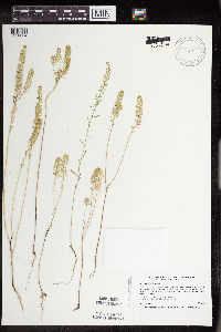 Lepidium densiflorum Schrader 520336[1356034]Smith, Welby 209721992-07-16 United States, Minnesota, Pennington, Pennington County ... on the west side of County Road 73, about 4.5 miles northwest of the center of Thief River Falls; in abandoned gravel pit ...T154N R44W NE1/4 of NE1/4 of Sec 13. 154N 44W 13, 48.163887 -96.2405548 |
MIN:Plants | Lepidium densiflorum Schrader 520602[]Smith, Welby 187651991-06-11 United States, Minnesota, Aitkin, Hill River State Forest. Aitkin Co.; Hill River State Forest, about 5 mi E of Hill City; along an old logging road; Aitkin Co.; Hill River State Forest, about 5 mi E of Hill City; along an old logging road, T52N R25W SW1/4 of NE1/4 of Sec 23. 052N 25W 23, 46.9805565 -93.4805527 |
MIN:Plants | Lepidium densiflorum Schrader 520694[]Smith, Welby 195481991-07-16 United States, Minnesota, Koochiching, Koochiching State Forest. Koochiching County...on the north side of TH 65, about 18 mi northwest of Silverdale...T65N R24W SE1/4 of NE1/4 of sec 3. 065N 24W 3, 48.1500015 -93.4186096 |
MIN:Plants | Lepidium densiflorum Schrader 520916[]Smith, Welby 195751991-07-17 United States, Minnesota, Itasca, Scenic State Park. Itasca Co.; Scenic State Park, about 3 mi SE of Big Fork; T60N R26W NE1/4 of NE1/4 of Sec 1 Itasca Co.; Scenic State Park, about 3 mi SE of Big Fork; T60N R26W NE1/4 of NE1/4 of Sec.1. 060N 26W 1, 47.7213898 -93.5805588 |
MIN:Plants | Lepidium densiflorum Schrader 526163[]Moore, John 210311951-06-25 United States, Minnesota, Todd, 1 1/2 mi. SE of Staples.;;N;;, 46.340161 -94.769991 |
MIN:Plants | Lepidium densiflorum Schrader 526478[]Smith, Welby 116621986-06-08 United States, Minnesota, Sherburne, Sherburne Co. Sherburne National Wildlife Refuge, about 2 1/2 mi SE of Orrock; SW1/4 SE1/4 sec.10, T34N R27W;Sherburne National Wildlife Refuge;034N;27W;10, 45.4444427 -93.6819458 |
MIN:Plants | Lepidium densiflorum Schrader 532753[]Lakela, Olga 200331956-06-24 United States, Minnesota, Saint Louis, S of Hwy. 23, near Pelican Lake at Orr.;Kabetogama State Forest;N;;, 48.06382 -92.90331 |
MIN:Plants | Lepidium densiflorum Schrader 541390[]Scharf, J. s.n.1956-07-27 United States, Minnesota, Pipestone, Pipestone Co.; Holland Marsh. 1 mi. east of Holland. [Holland WMA?];Holland Wildlife Management Area;107N;44W;00, 44.066322 -96.124397 |
MIN:Plants | Lepidium densiflorum Schrader 548921[]Pease, T. 21888-08-24 United States, Minnesota, Anoka, Anoka;;N;;, 45.268067 -93.24412 |
MIN:Plants | Lepidium densiflorum Schrader 553982[]Moore, John; et al. 224011954-09-24 United States, Minnesota, Pipestone, Pipestone County...near the falls, Pipestone National Monument, Pipestone.;Pipestone National Monument;146N;06W;01, 44.013519 -96.324755 |
MIN:Plants | Lepidium densiflorum Schrader 554235[]Moore, John 229211956-06-14 United States, Minnesota, Norman, 6 mi. E of Lockhart.;;N;;, 47.439896 -96.422772 |
MIN:Plants | Lepidium densiflorum Schrader 558192[]Moore, John 237731958-06-10 United States, Minnesota, Kittson, 5 mi. W of Karlstad.;;N;;, 48.577425 -96.629968 |
MIN:Plants | Lepidium densiflorum Schrader 566383[]Moore, John; Heig, V. 241331958-09-10 United States, Minnesota, Kittson, 3 mi. NW of Lake Bronson;;N;;, 48.758982 -96.703876 |
MIN:Plants | Lepidium densiflorum Schrader 566601[]Moore, John; et al. 239681958-06-24 United States, Minnesota, Anoka, on laboratory grounds at Cedar Creek Forest.;Cedar Creek National History Area;034N;23W;27, 45.406779 -93.193727 |
MIN:Plants | Lepidium densiflorum Schrader 566661[]Moore, John; Heig, V. 239961958-09-08 United States, Minnesota, Kittson, On a vacant lot at Hallock.;;N;;, 48.774426 -96.946447 |
MIN:Plants | Lepidium densiflorum Schrader 572784[]Moore, John; et al. 256261961-07-18 United States, Minnesota, Isanti, In old field E of county roadway 1/2 mi. E of the Lundgren Farmstead, Cedar Creek Natural History Area.;Cedar Creek National History Area;034N;23W;, 45.428063 -93.203997 |
MIN:Plants | Lepidium densiflorum Schrader 585686[]Moore, John 261211962-06-29 United States, Minnesota, Kittson, Hallock;;N;;, 48.774426 -96.946447 |
MIN:Plants | Lepidium densiflorum Schrader 592419[]Westkaemper, Remberta s.n.1965-06-00 United States, Minnesota, Stearns, Stearns Co. St. Joseph. St. Benedict College campus.;;124N;29W;, 45.543642 -94.322053 |
MIN:Plants | Lepidium densiflorum Schrader 594139[]Thorne, Robert 305071962-06-18 United States, Minnesota, Clearwater, Opposite Campus of Univ. of Minnesota Biological Station, Itasca State Park.;Itasca State Park;143N;36W;, 47.19557 -95.233216 |
MIN:Plants | Lepidium densiflorum Schrader 594531[]Wadekamper, J. 1301965-09-16 United States, Minnesota, Rice, 1/2 mi. NW of Faribault.;;N;;, 44.300084 -93.275981 |
MIN:Plants | Lepidium densiflorum Schrader 594684[]Moore, John; Goodwin, D. 271946-10-19 United States, Minnesota, Crow Wing, along the s shore of Rabbit Lake;;N;;, 46.530365 -93.924032 |
MIN:Plants | Lepidium densiflorum Schrader 595356[]Cahoon, E. 791956-07-08 United States, Minnesota, Brown, Och's Clay Pit, ca. 1 mi. SW of Springfield.;;N;;, 44.227814 -94.988739 |
MIN:Plants | Lepidium densiflorum Schrader 616449[]Moore, John; Moore, Marjorie 1371969-06-17 United States, Minnesota, Crow Wing, Crow Wing Natural History Area. S end of Chandler Lake, SW1/4 Sec. 22, Garrison Twp.;Crow Wing Natural Area;044N;28W;22, 46.27899 -93.863336 |
MIN:Plants | Lepidium densiflorum Schrader 617053[]Siemers, Ross 471977-06-09 United States, Minnesota, Morrison, MacDougall Homestead Preserve.;MacDougall Homestead, The Nature Conservancy;039N;32W;, 45.868856 -94.31068 |
MIN:Plants | Lepidium densiflorum Schrader 618901[]Monserud, W. 1401949-06-06 United States, Minnesota, Hennepin, Back yard at 5255 Dupont Ave. N, Minneapolis.;;N;;, 44.9074 -93.29345 |
MIN:Plants | Lepidium densiflorum Schrader 636249[]Disrud, D. s.n.1965-07-03 United States, Minnesota, Anoka, T34N, R23W, Sec. 27, NE1/4 of NE1/4;Cedar Creek National History Area;034N;23W;27, 45.406779 -93.193727 |
MIN:Plants | Lepidium densiflorum Schrader 670607[]Heitlinger, M. 2881971-07-11 United States, Minnesota, McLeod, Schaefer Prairie. On W-facing slope of N-S ridge. SE1/4 of Sec. 34, T115N.;Schaefer Prairie, The Nature Conservancy;115N;29W;34, 44.72505 -94.30491 |
MIN:Plants | Lepidium densiflorum Schrader 670803[]Heitlinger, M. 5601972-06-01 United States, Minnesota, McLeod, Schaefer Prairie. SE1/4 of Sec. 34, T115N, R29W.;Schaefer Prairie, The Nature Conservancy;115N;29W;34, 44.72505 -94.30491 |
MIN:Plants | Lepidium densiflorum Schrader 678920[]Ownbey, Gerald 49381975-06-27 United States, Minnesota, Clearwater, 6.8 mi. N of Clearbrook, W side of Rte. 5.;;N;;, 47.79709 -95.441153 |
MIN:Plants | Lepidium densiflorum Schrader 681005[]Swanson, Steven 5181975-06-14 United States, Minnesota, Houston, Mississippi River (Navigation Pool #8). Houston Co, Site 11. A steep r.r. bank on the W side of the main channel.;Upper Mississippi National Wildlife Refuge;N;;, 43.763684 -91.282376 |
MIN:Plants | Lepidium densiflorum Schrader 685087[]Stassen, Carol 311976-06-18 United States, Minnesota, Lyon, Camden State Park. At old gravel pit site near park entrance. T110N, R42W, Sec. 5, SE1/4.;Camden State Park;110N;42W;5, 44.363323 -95.947736 |
MIN:Plants | Lepidium densiflorum Schrader 687023[]Wheeler, Gerald; Glaser, Paul 14491977-05-28 United States, Minnesota, Itasca, Site 28. NW1/4 SW1/4 Sec. 24, T55N, R27W; ca. 7.5 mi. W of Grand Rapids.;;055N;27W;24, 47.232154 -93.713272 |
MIN:Plants | Lepidium densiflorum Schrader 687053[]Wheeler, Gerald; Glaser, Paul 14791977-05-28 United States, Minnesota, Itasca, Site 33. SW1/4 NW1/4 T54N, R26W; ca. 8.5 mi. SW of Grand Rapids.;;054N;26W;28, 47.130995 -93.651027 |
MIN:Plants | Lepidium densiflorum Schrader 690018[]Ownbey, Gerald 55541977-06-08 United States, Minnesota, Washington, Northern outskirts of Afton village near Hwy. 95.;;028N;20W;, 44.907173 -92.81202 |
MIN:Plants | Lepidium densiflorum Schrader 690508[]Siemers, Ross 501977-06-28 United States, Minnesota, Stearns, Stearns Co. Great Blue Heron Rookery Area - Observation Hill. T123N R30W Sec.13.;Cold Spring Heron Colony Scientific Natural Area;123N;30W;13, 45.463971 -94.394322 |
MIN:Plants | Lepidium densiflorum Schrader 693883[]Roefer, Florence s.n.1978-05-28 United States, Minnesota, Cottonwood, Jeffers Petroglyph Historic Site. T107N R35W NW1/4 Sec.9 Delton Twp.;Jeffers Petroglyphs Historical Site;107N;35W;9, 44.086452 -95.049966 |
MIN:Plants | Lepidium densiflorum Schrader 693884[]Roefer, Florence s.n.1978-07-09 United States, Minnesota, Cottonwood, Jeffers Petroglyph Historic Site. T107N R35W NW1/4 Sec.9 Delton Twp.;Jeffers Petroglyphs Historical Site;107N;35W;9, 44.086452 -95.049966 |
MIN:Plants | Lepidium densiflorum Schrader 695841[]Clemants, Steven 12771978-06-20 United States, Minnesota, Crow Wing, 1/2 mi. N of the town of Crow Wing. T144N, R31W intersection sections 16, 17, 19, 20.;;144N;31W;, 46.287206 -94.2925 |
MIN:Plants | Lepidium densiflorum Schrader 698282[]Wheeler, Gerald; Glaser, Paul 30821978-06-30 United States, Minnesota, Beltrami, Red Lake Peatland Scientific Natural Area. Red Lake Peatland: NW1/4 NE1/4 Sec. 1, T156N, R31W; ca. 14.5 mi. N of the Waskish Airport on Rte. 72, just W of the roa Red Lake Peatland: NW1/4 NE1/4 Sec. 1, T156N, R31W; ca. 14.5 mi. N of the Waskish Airport on Rte. 72, just W of the road.. 156N 31W 1, 48.359967 -94.564698 |
MIN:Plants | Lepidium densiflorum Schrader 699723[]Ziegler, S.; et al. 12091975-06-13 United States, Minnesota, Houston, Upper Mississippi National Wildlife Refuge. Mississippi River Navigation Pool #8. Island 12. Mississippi River mile #690.5; T103N, R04W Sec. 13...Island on the W side of main channel. Near the center of the island.. 103N 04W 13, 43.725044 -91.265964, 194m |
MIN:Plants | Lepidium densiflorum Schrader 700934[]Dorio, J. 6551977-07-26 United States, Minnesota, Morrison, Lake Alexander, ca. 7 mi. N of Randall on Co. Rd. 6. T131N, R30W, Sec. 6.;;131N;30W;6, 46.187068 -94.506235 |
MIN:Plants | Lepidium densiflorum Schrader 701365[]Dorio, J. 3841977-06-28 United States, Minnesota, Morrison, Co.: Morrison ... Sandhill Crane Meadow, 4.5 mi. W of Buckman on Hwy. 34. T39N, R31W, Sec. 3 & 4.;Crane Meadows National Wildlife Refuge;039N;31W;, 45.86753 -94.198919 |
MIN:Plants | Lepidium densiflorum Schrader 704677[]Smith, Welby 19891979-08-16 United States, Minnesota, Wabasha, 20 m e of co. rd. 84. T109N R9W NE1/4 SW1/4 sec.7.;Kellogg-Weaver Dunes Scientific Natural Area / Kellogg-Weaver Dunes, The Nature Conservancy;109N;09W;7, 44.258106 -91.93891 |
MIN:Plants | Lepidium densiflorum Schrader 708015[]Smith, Welby 13341979-08-02 United States, Minnesota, Redwood, Redwood Co. 6.5 mi N-NE of Morgan; S of Wabasha Creek and N of co. hwy 10. T112N R34W NW1/4 SE1/4 sec.14.;;112N;34W;14, 44.506793 -94.895945 |
MIN:Plants | Lepidium densiflorum Schrader 708073[]Smith, Welby 14161979-08-22 United States, Minnesota, Clay, Clay County...Buffalo River State Park. 7.5 mi W-SW of Hawley. T139N R46W NW1/4 sec.15.;Buffalo River State Park;139N;46W;15, 46.854948 -96.473403 |
MIN:Plants | Lepidium densiflorum Schrader 710065[]Wheeler, Gerald 50951979-10-06 United States, Minnesota, Le Sueur, Le Sueur Co. Approx. 1 mi sw of Kasota; bluff overlooking the Minnesota River. High Lime Prairie. T109N R26W Sec.6.;East Minnesota River Wildlife Management Area;109N;26W;6, 44.274575 -93.998474 |
MIN:Plants | Lepidium densiflorum Schrader 711682[]Smith, Welby 17591979-08-30 United States, Minnesota, Goodhue, 3/8 mi NW of where e-w co. 18 crosses tracks of the St. Paul & Pacific R.R. T114N R16W SW1/4 sec.15.;;114N;16W;15, 44.67995 -92.722544 |
MIN:Plants | Lepidium densiflorum Schrader 712070[]Smith, Welby 13651979-08-13 United States, Minnesota, Wright, Wright Co.; 0.2 mi N of co. hwy 75, 5.5 mi nw of its jnc with state hwy 25 in Monticello. T122N R25W SE1/4 NW1/4 sec.30.;;122N;25W;30, 45.345989 -93.884027 |
MIN:Plants | Lepidium densiflorum Schrader 712143[]Smith, Welby 18891979-09-13 United States, Minnesota, Wright, Wright co.; Lake Marie [sic] Park. About 1/4 mi NW of the jnc of co. rd. 111 and 39. T121N R26W SE1/4 NE1/4 sec.10.;Lake Maria State Park;121N;26W;10, 45.303961 -93.942892 |
MIN:Plants | Lepidium densiflorum Schrader 717020[]Heitlinger, M. 7331975-07-08 United States, Minnesota, Anoka, Anoka Co. Allison Savanna; in n central portion of tract. N1/2 of NE1/4 of Sec. 2 T33N R23W.;Helen Allison Savanna Scientific Natural Area;033N;23W;2, 45.377702 -93.173879 |
MIN:Plants | Lepidium densiflorum Schrader 717415[]Mathisen, Ron 1171979-07-11 United States, Minnesota, Hubbard, Spearhead Lake Reserve;Spearhead Lake Preserve (Audubon);145N;34W;, 47.368099 -94.990966 |
MIN:Plants | Lepidium densiflorum Schrader 722493[]Lustig, K. 3941979-06-05 United States, Minnesota, Anoka, Anoka County...Boot Lake SNA: 18 mi. SE of Cambridge, Sec. 17, 18, 20, T33N, R22W.;Boot Lake Scientific Natural Area;033N;22W;00, 45.340658 -93.081463 |
MIN:Plants | Lepidium densiflorum Schrader 722692[]Lustig, K. 4921979-06-14 United States, Minnesota, Anoka, Anoka County...Boot Lake SNA: 18 mi se of Cambridge, Sec.17, 18, 19, 20 T33N R22W.;Boot Lake Scientific Natural Area;033N;22W;00, 45.340658 -93.081463 |
MIN:Plants | Lepidium densiflorum Schrader 724942[]Smith, Welby 26961980-07-06 United States, Minnesota, Wright, Wright Co.; on the E side of co. hwy 25, about 1 1/4 mi s of its jnc with state hwy 12 in Montrose. T118N R26W SW1/4 sec Wright Co.; on the E side of co. hwy 25, about 1 1/4 mi s of its jnc with state hwy 12 in Montrose. T118N R26W SW1/4 sec.12.. 118N 26W 12, 45.043113 -93.900405 |
MIN:Plants | Lepidium densiflorum Schrader 726398[]Smith, Welby 29371980-07-20 United States, Minnesota, Wright, Wright Co.; on the W bank of the Mississippi River, about 1/8 mi S of state hwy 101 crossing. T121N R23W SW1/4 Sec.14.;;121N;23W;14, 45.284891 -93.558229 |
MIN:Plants | Lepidium densiflorum Schrader 726415[]Smith, Welby 32921980-08-10 United States, Minnesota, Wright, Wright Co.; between the N shore of Buffalo Lake and co. hwy. 9. T120N R26W SW1/4 NE1/4 sec.25.;;120N;26W;25, 45.172559 -93.899917 |
MIN:Plants | Lepidium densiflorum Schrader 728587[]Eikum, B. 841979-06-18 United States, Minnesota, Dakota, Hastings;Hastings Scientific Natural Area;115N;17W;, 44.73907 -92.86266 |
MIN:Plants | Lepidium densiflorum Schrader 734478[]Petron, T. 1391980-06-23 United States, Minnesota, Clay, Bluestem Prairie: 13 mi E of Moorhead. SW1/4 SE1/4 sec.23 T139N R46W.;Bluestem Prairie Scientific Natural Area;139N;46W;23, 46.840194 -96.452227 |
MIN:Plants | Lepidium densiflorum Schrader 734787[]Severson, M. 2821980-06-11 United States, Minnesota, Becker, Green Water Lake Natural Area: 5 mi w of Ponsford. NE1/4 SE1/4 Sec.33 T141N R38W.;Greenwater Lake Scientific Natural Area / White Earth Indian Reservation;141N;38W;33, 46.983894 -95.497699 |
MIN:Plants | Lepidium densiflorum Schrader 738412[]Galatowitsch, S. 1391982-05-30 United States, Minnesota, Wabasha, Wabasha County...Weaver Dunes: T109N R9W SE1/4 and E1/2 NE1/4 of Sec.7; NW1/4 W1/2 NE1/4 of Sec.8.;Kellogg-Weaver Dunes Scientific Natural Area / Kellogg-Weaver Dunes, The Nature Conservancy;109N;09W;00, 44.233108 -91.917245 |
MIN:Plants | Lepidium densiflorum Schrader 739963[]Converse, C. 9181982-05-31 United States, Minnesota, Chippewa, Chippewa and Swift Cos. Chippewa Prairie: NE1/4 NW1/4 Sec.13 T119N R43W.;Chippewa Prairie, The Nature Conservancy;119N;43W;13, 45.110235 -95.996766 |
MIN:Plants | Lepidium densiflorum Schrader 743980[]Wheeler, Gerald 67541982-06-12 United States, Minnesota, Renville, Renville Co. NW of Morton. T113N, R34W, Sec. 31, NW1/4.;;113N;34W;31, 44.543269 -94.990327 |
MIN:Plants | Lepidium densiflorum Schrader 744605[]Converse, C. 11461982-06-15 United States, Minnesota, Pope, Ordway Prairie: T123N, R36W, SW1/4 NW1/4 Sec. 30.;Ordway Prairie, The Nature Conservancy;123N;36W;, 45.434262 -95.245018 |
MIN:Plants | Lepidium densiflorum Schrader 744759[]Converse, C. 10801982-06-10 United States, Minnesota, Chippewa, Chippewa and Swift Cos. Chippewa Prairie: T119N, R43W, SW1/4 SW1/4 Sec. 12.;Chippewa Prairie, The Nature Conservancy;119N;43W;12, 45.130213 -95.990566 |
MIN:Plants | Lepidium densiflorum Schrader 745368[]Smith, Welby 44251981-06-24 United States, Minnesota, Mower, Wild Indigo Scientific Natural Area. Wild Indigo Scientific and Natural Area. Ca. 4 mi. SW of the jct. of Hwy. 56 and Hwy. 2 in Brownsdale. NE1/4 NW1/4 Sec Wild Indigo Scientific and Natural Area. Ca. 4 mi. SW of the jct. of Hwy. 56 and Hwy. 2 in Brownsdale. NE1/4 NW1/4 Sec. 24, T103N, R18W.. 103N 18W 24, 43.710437 -92.939849 |
MIN:Plants | Lepidium densiflorum Schrader 745516[]Smith, Welby 44781981-06-24 United States, Minnesota, Mower, Wild Indigo Scientific Natural Area. Wild Indigo Scientific and Natural Area. Ca. 2 1/4 mi. E of the jct. of Hwy. 56 and Hwy. 2 in Brownsdale. SE1/4 SW1/4 Wild Indigo Scientific and Natural Area. Ca. 2 1/4 mi. E of the jct. of Hwy. 56 and Hwy. 2 in Brownsdale. SE1/4 SW1/4 Sec. 12, T103N, R17W.. 103N 17W 12, 43.7396 -92.819238 |
MIN:Plants | Lepidium densiflorum Schrader 753108[]Boe, J. 19511983-07-01 United States, Minnesota, Kittson, Norway Dunes: SW1/4 SE1/4 Sec. 10; T160N.;Norway Dunes, The Nature Conservancy;160N;46W;10, 48.695736 -96.57277 |
MIN:Plants | Lepidium densiflorum Schrader 753780[]Duxbury, Alexis 18671983-07-24 United States, Minnesota, Nobles, Compass Prairie: part of SE1/4 SW1/4 Sec. 3; T101N, R41W.;Compass Prairie Scientific Natural Area;101N;41W;3, 43.580108 -95.743853 |
MIN:Plants | Lepidium densiflorum Schrader 758870[]Smith, Welby 63981982-06-15 United States, Minnesota, Mower, Racine Prairie Scientific Natural Area. Racine Prairie State Scientific and Natural Area. Adjacent to the E side of Hwy. 63, ca. 2 mi. N of Racine. NE1/4 NE1/ Racine Prairie State Scientific and Natural Area. Adjacent to the E side of Hwy. 63, ca. 2 mi. N of Racine. NE1/4 NE1/4 Sec. 22, T104N, R14W.. 104N 14W 22, 43.797643 -92.499267 |
MIN:Plants | Lepidium densiflorum Schrader 764046[]Foote, Lewis s.n.1886-07-15 United States, Minnesota, Nobles, Worthington;;N;;, 43.619964 -95.596398 |
MIN:Plants | Lepidium densiflorum Schrader 764047[]Foote, Lewis s.n.1898-07-00 United States, Minnesota, Nobles, Worthington;;N;;, 43.619964 -95.596398 |
MIN:Plants | Lepidium densiflorum Schrader 770228[]Smith, Welby 81501983-06-21 United States, Minnesota, Wabasha, Kellogg-Weaver Dunes Scientific Natural Area / Kellogg-Weaver Dunes, The Nature Conservancy. Kellogg-Weaver Dunes State Scientific and Natural Area. About 4 mi se of Kellogg, on the e side of co. rd. 84. SE1/4 NE1 Kellogg-Weaver Dunes State Scientific and Natural Area. About 4 mi se of Kellogg, on the e side of co. rd. 84. SE1/4 NE1/4 Sec.6 T109N R9W.. 109N 09W 6, 44.272608 -91.938983 |
MIN:Plants | Lepidium densiflorum Schrader 772519[]Boe, J. 9941979-07-20 United States, Minnesota, Lake of the Woods, Spina Trail. 2.7 mi. SW of Range Line. NW1/4 Sec. 11, R34W, T158N.;;158N;34W;11, 48.518083 -94.983787 |
Google Map
Google Maps is a web mapping service provided by Google that features a map that users can pan (by dragging the mouse) and zoom (by using the mouse wheel). Collection points are displayed as colored markers that when clicked on, displays the full information for that collection. When multiple species are queried (separated by semi-colons), different colored markers denote each individual species.