University of Minnesota
http://www.umn.edu/
612-625-5000
http://www.umn.edu/
612-625-5000
Minnesota Biodiversity Atlas
Bell Museum
Dataset: MIN-Plants
Taxa: Lycopodiaceae
Search Criteria: excluding cultivated/captive occurrences
Bell Museum plants | |
 MIN:Plants | 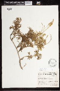 Diphasiastrum x habereri (House) Holub 470277[1327175]Marie-Victorin 1941-09-07 Canada, Quebec, Portnuef, St. Augustin, neighboring the river |
MIN:Plants | 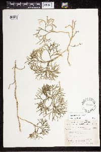 Diphasiastrum x habereri (House) Holub 470526[1327176]Clausen, Robert T. 1944-04-02 United States, New York, Tompkins, Allegheny Plateau, slope along tributary of Six Mile Creek, 5 km S of Dryden, 485m |
MIN:Plants | 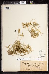 Diphasiastrum x habereri (House) Holub 55214[1327177]Fisher, G.L. 1898-08-04 Canada, Ontario, Dorset |
MIN:Plants | 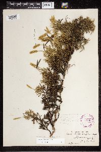 Diphasiastrum x habereri (House) Holub 264892[1327178]Pammel, L.H. 1927-08-15 United States, Michigan, Ishpeming |
MIN:Plants | 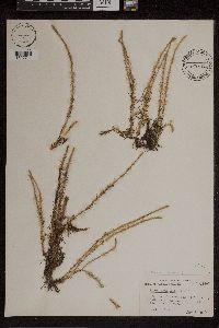 447287[1307744]Abbott, Robinson S. s.n.1955-07-26 United States, Massachusetts, Barnstable, bog near Summerfield Pond, 10 mi. N.E. pf Woods Hol on rt. 28 near traffic circle |
MIN:Plants | 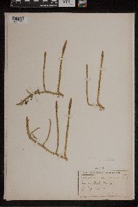 55318[1307748]Lyon, H.L. 6281900-07-12 United States, Massachusetts, Barnstable |
MIN:Plants | 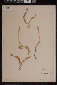 55316[1307749]Eaton, A.A. 901895-09-00 United States, New Hampshire, Rockingham |
MIN:Plants | 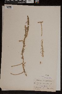 55141[1307750]Lighthipe, Rev. L.H. 2221894-09-10 United States, New Jersey, Middlesex, near Woodbridge |
MIN:Plants |  279119[1307751]Carpenter, D.S. s.n.1920-07-14 United States, Vermont, Rutland |
MIN:Plants |  55315[1307752]Howell, T. 17311895-08-07 United States, Alaska, Ketchikan gateway, Yes Bay |
MIN:Plants |  380428[1307753]Chamberlain, E.B. s.n.1903-09-12 United States, Maine, Cumberland, Cumberland; "The Meadow", 43.79594 -70.259613 |
MIN:Plants |  55313[1307754]Fernald, M.L. s.n.1891-07-16 United States, Maine, York, Chases Pond |
MIN:Plants |  388070[1307755]Wadmond, S.C. s.n.1941-08-06 United States, Michigan, Kalamazoo, Eagle Lake border |
MIN:Plants |  452496[1307756]Durand, E.J. s.n.1905-07-29 United States, New York, Seneca |
MIN:Plants |  523333[1307757]Cooper, W.S. s.n.1903-09-26 United States, Michigan, Montcalm |
MIN:Plants |  593189[1307758]Hartley, T.G. 47671958-07-20 United States, Wisconsin, Jackson, near "Indian Grave Creek" |
MIN:Plants |  522836[1307759]Cooper, W.S. s.n.1906-08-06 United States, Michigan, Chippewa, Fire Island |
MIN:Plants |  553426[1307760]Rolland-Germain, F. 62001955-08-06 Canada, Quebec, Laurentides |
MIN:Plants |  55306[1307761]Eaton, A.A. s.n.1895-09-00 United States, New Hampshire, Rockingham |
MIN:Plants |  55311[1307762]Fernald, M.L. 4362 Canada, Newfoundland, quarry ;;; Laurentian Area at head of Exploits River System |
MIN:Plants | 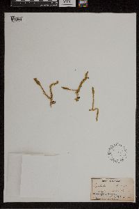 55304[1307763]Small, J.K. s.n.1889-08-16 United States, Pennsylvania, Lancaster |
MIN:Plants | 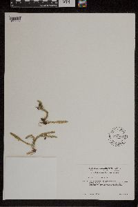 594957[1307764]Baldwin, W.K.W. 93641961-08-05 Canada, Ontario, Kenora, Upper English River Forest section in part ;;; 7 miles northwest of Ignace at Osaquan River ;;; near Jorgenson's road ;;;, 49.45 -91.8 |
MIN:Plants | 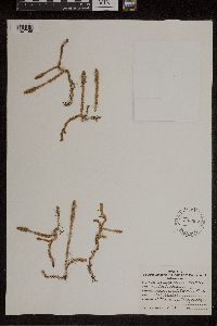 530962[1307765]Rood, A.N. s.n.1928-07-22 United States, Ohio, Trumbull |
MIN:Plants | 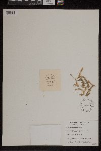 528434[1307766]Garton, C.E. 17471951-09-23 Canada, Ontario, Thunder Bay, South edge of town ;;; Two Island Lake Road |
MIN:Plants |  55307[1307767] 508 United States, New York |
MIN:Plants |  55308[1307768]Small, J.K. s.n.1889-07-16 United States, Pennsylvania, Lancaster |
MIN:Plants |  55305[1307769]Macoun, J. s.n.1888-08-31 Canada, Prince Edward Island |
MIN:Plants |  301679[1307770]Bright, J. 72011932-08-13 United States, Pennsylvania, Fayette, The M.m.r.r. bridge across the Youghioheny River |
MIN:Plants | 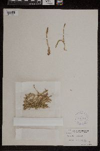 303238[1307771]Muenscher, W.C. 41111934-08-18 United States, New York, Hamilton, Shore of East Stoner Lake |
MIN:Plants | 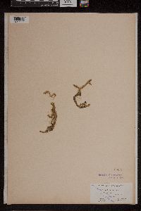 55309[1307772]Robinson, B.L. 1351894-08-06 Canada, Newfoundland and Labrador, 1st census division, Bally Hailey Bog |
MIN:Plants | 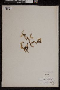 55310[1307773]Waghorne, A.C. s.n.1819-10-08 Canada, Newfoundland and Labrador, quarry near [illegible] |
MIN:Plants | 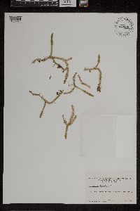 643878[1307774]Ahles, H.E. 692861967-08-15 United States, New Hampshire, Hillsborough, Pleasant Pond, north of Francestown |
MIN:Plants |  337245[1307775]Steinmetz, F.H. 6101936-09-02 United States, Maine, Penobscot, island in Chemo Pond |
MIN:Plants |  388069[1307776] 2001896-09-00 United States, New Hampshire, Rockingham |
MIN:Plants |  260893[1307777]Eggleston, W.W. 21971900-08-10 United States, Vermont |
MIN:Plants |  55314[1307778]Fernald, M.L. 43651911-08-23 Canada, Newfoundland, Laurentian area at Head of Exploits River System |
MIN:Plants |  388068[1307779]Eames, E.H. 11,1751930-09-03 United States, Connecticut, New Haven |
MIN:Plants |  273466[1307780]Beals, A.T. 1922-07-03 United States, New Jersey, Atlantic |
MIN:Plants |  55312[1307781] 901880-09-00 United States, Massachusetts, Middlesex |
MIN:Plants |  333778[1307782]True, Rodney H. 721933-08-23 United States, New York, Oneida, White lake, Woodgate |
MIN:Plants |  291037[1307783]Bright, John 100671934-10-17 United States, Pennsylvania, Fayette, Ohiopyle (state park) |
MIN:Plants | 959212[1307777] United States, New Hampshire |
MIN:Plants | 959211[1307777] United States, Maine |
MIN:Plants |  680114[1307784]Ahles, Harry E. 823991976-08-30 United States, Massachusetts, Hampshire, Plain Road, Hatfield |
MIN:Plants |  267340[1307785]Fassett, N.C. 76881928-09-06 United States, Wisconsin, Douglas, Whitefish Lake |
MIN:Plants |  766624[1307786]Lugger, O. 1866-00-00 United States, Michigan, Mackinac, w. part of L. S. |
MIN:Plants |  775840[1307787]Cooper, William S. 481928-07-13 United States, Oregon, Coos, Coos Bay |
MIN:Plants |  812045[1307788]Bursik, R. 3211987-07-05 United States, Idaho, Bonner, Panhandle National Forest, Kaniksu Marsh RNA; NW 1/4 sec. 24, T59N, R4E, ca. 8 miles S of Priest Lk, ID, 756m |
MIN:Plants |  817300[1307789]Bursik, R. 14341988-07-31 United States, Idaho, Bonner, Panhandle national Forest, Hager Lake |
MIN:Plants |  55329[1341723]Simon, F. s.n.1895-09-16 France, Gallia, Aveyron, 44.296688 2.711326 |
MIN:Plants | 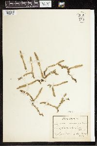 55330[1341724]Semler, Carl s.n.1900-08-29 Germany, Sumpf zwischen Firth und Vach[?], 53.733333 9.083333 |
MIN:Plants | 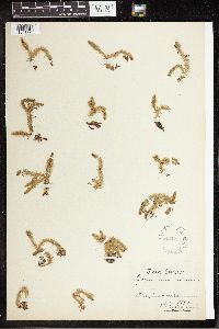 55337[1341725]Heselman, H. s.n.1894-07-00 Sweden, Helsingland, 61.5 17 |
MIN:Plants | 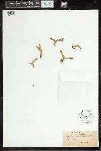 55333[1341726]Montelin, G.W. s.n.1886-00-00 Sweden, 62 15 |
MIN:Plants | 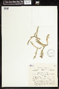 552861[1341727]Ambroz, J. 3011933-08-23 Czech Republic, Bohemia, Rozmberk near Trebon, 49.005636 14.763256, 425m |
MIN:Plants |  552866[1341728]Suza, Jindr 3021935-07-26 Czech Republic, Bohemia, near Tust and near Trebon, 49.005636 14.763256, 480m |
MIN:Plants |  55343[1341729]Krause, H. s.n.1900-09-02 Germany, Pomerania, Halpasfal, 53.666667 15 |
MIN:Plants |  299247[1341730]Bertoch, K. s.n.1911-07-08 Germany, Wurttemberg; Oberschwaben. Eglof, 48 9.583333 |
MIN:Plants |  220322[1341731]Lugger, Otto s.n. Germany, Bonn, 50.715833 7.111389 |
MIN:Plants |  55003[1341732]Veaudes, G. s.n.1890-07-00 Scandinavia, 62.26531 23.184895 |
MIN:Plants |  260880[1341733]Preif s.n.1894-09-07 Germany, near Dulmen, 51.831487 7.280754 |
MIN:Plants |  55338[1341734]Bagenholm, Gosta s.n.1895-06-00 Sweden, [illegible], 62.195449 15.710938 |
MIN:Plants |  341143[1341735]Ball, H. s.n.1916-08-25 Sweden, Vestrogothia, Boras Bosjon, 57.716667 12.916667 |
MIN:Plants |  55340[1341736]Fashinfam[?] s.n.1883-08-00 Scandinavia, 63.231098 19.317708 |
MIN:Plants |  55341[1341737]R.H.M. s.n.1887-07-00 United Kingdom, Near Dunkeld, Perthshire, 56.566667 -3.583333 |
MIN:Plants |  55342[1341738]de Chambuie s.n.1847-07-25 France, Paris, St. Leger, 48.861445 2.337019 |
MIN:Plants |  55331[1341739]Vierhapper s.n.1886-07-00 Austria, [illegible], 47.224529 13.162109 |
MIN:Plants |  55332[1341740]Heynmeit, E.R. s.n.1901-09-03 Germany, Bachthale, Tauscha, and Lotzschen, 50.643507 11.656441 |
MIN:Plants | 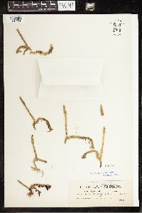 55344[1341741]Paulin 1101 Slovenia, Carniolia, near Labacum, 46.222228 13.964111, 300m |
MIN:Plants | 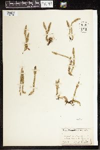 55339[1341742]Ivepffer, A. s.n.1900-08-14 Germany, Schevernia, Gorenrikeu[?], 51.128797 10.583984 |
MIN:Plants | 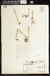 55345[1341743]Schulz, P.F.F. s.n.1907-08-00 Germany, Ufer, Glubigsee, 51.316667 7.516667 |
MIN:Plants | 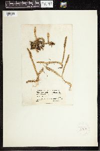 220315[1341744]Fischer, L. 7001869-00-00 Switzerland, Marais de Lossy bei Genf., 46.762114 7.444666 |
MIN:Plants | 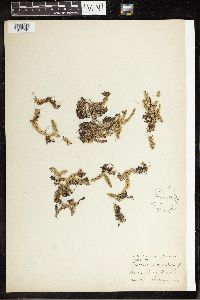 55334[1341745]Bagenholm, G. s.n.1905-08-00 Norway, Mosjoen, 59.816667 11 |
MIN:Plants | 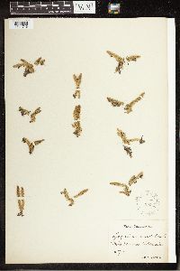 55335[1341746] Norway |
MIN:Plants | 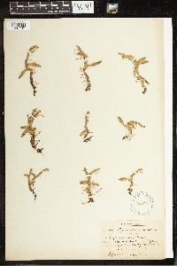 55336[1341747]Bagenholm, Gosta s.n.1893-08-00 Sweden, Smaland, Vasby and Daderja, 59.833333 14.666667 |
MIN:Plants | 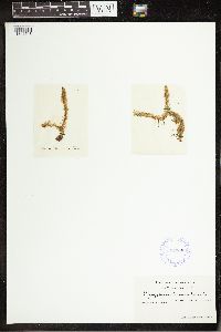 384398[1341748] 5991800-00-00 Europe, 50.285752 18.966145 |
MIN:Plants | 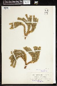 55398[1341779]Dorfler 1901 Austria, Katzenstein mountains near Gmunden, 47.916667 13.8, 1000m |
MIN:Plants |  976726[1402335]Timothy J. S. Whitfeld 29982021-07-20 United States, Minnesota, St. Louis, Between Crane Lake and Dovre Lake, 48.273661 -92.4459, 369m |
MIN:Plants |  976119[1373672]Smith, Welby R WRS368512020-08-17 United States, Minnesota, Anoka, Wollan Park in Lino Lakes. In a very diverse wet meadow community., 45.2062 -93.09985 |
MIN:Plants |  Lycopodium canadense NULL 917155[1339824]Gerdes, Lynden 57972009-07-14 United States, Minnesota, Cook, Greenwood Lake area. North of FR 313 and approx. 0.13 miles south of Tittle Lake. NAD 712211 / 5322913 SENWSE of section;Superior National Forest;064N;02E;14, 48.0241667 -90.1536111 |
MIN:Plants |  Lycopodium canadense NULL 917072[1339823]Gerdes, Lynden B. 58962009-08-23 United States, Minnesota, Cook, Approximately 0.30 miles SE of Lone Lake. UTM: 650070 / 5338696. SWNENESW of section;Boundary Waters Canoe Area Wilderness / Superior National Forest;066N;05W;21, 48.1837619 -90.9809903 |
MIN:Plants |  Lycopodium canadense NULL 915077[1339827]Smith, Welby R. 314262009-08-29 United States, Minnesota, Cook, On the north side of Winchell Lake. NW1/4 of SE1/4 of Section;Boundary Waters Canoe Area Wilderness / Superior National Forest;064N;02W;30, 47.9941667 -90.6247222 |
MIN:Plants |  Lycopodium canadense NULL 917058[1339812]Gerdes, Lynden 58602009-08-10 United States, Minnesota, Cook, Approximately 0.41 miles NNW of Lichen Lake. Just southeast off small bog lake. UTM: 669364 / 5302119. NWNESESW of section;Superior National Forest;062N;03W;17, 47.8500811 -90.7360617 |
MIN:Plants |  Lycopodium canadense NULL 493398[1311301]Gerdes, Lynden 49382004-08-26 United States, Minnesota, Lake, Approximately 6.14 miles N of Isabella, MN and 1.35 mile SW of Helen Lake. East of the Northwest Road (FR 373) ~ 0.10 mile. NESWS [sic] of section;Superior National Forest;060N;08W;04, 47.707351 -91.344749 |
MIN:Plants | 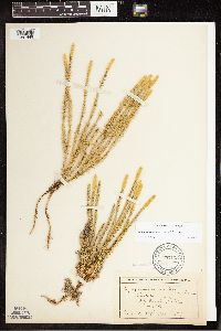 Lycopodium canadense Nessel 55103[1341449]Wheeler, William 8471900-08-00 United States, Michigan, Keweenaw, Tobin's Harbor, Isle Royale;Isle Royale National Park;;;, 48.010955 -88.828422 |
MIN:Plants | 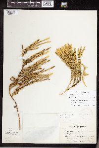 Lycopodium canadense NULL 281990[1339817]Butters, F.K. 62321930-08-19 United States, Minnesota, Cook, Lucille Island;North Shore / Susie Islands, The Nature Conservancy;064N;07E;00, 47.973776 -89.578978 |
MIN:Plants | 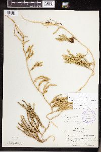 Lycopodium canadense NULL 289023[1339818]Rosendahl, C.O. 62481930-08-19 United States, Minnesota, Cook, W end of nearest island to Pigeon Point [S side], Grand Portage;Grand Portage Indian Reservation / North Shore;064N;07E;00, 47.997942 -89.538143 |
MIN:Plants | 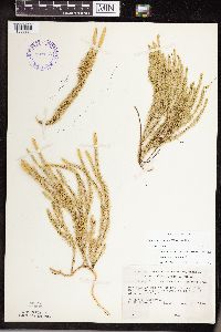 Lycopodium canadense NULL 393173[1339831]Ownbey, Gerald B. 10061948-08-11 United States, Minnesota, Cook, NE of Hovland near Big Bay, Hwy.#61;Grand Portage State Forest / North Shore;062N;04E;00, 47.9333 -89.9333 |
MIN:Plants |  Lycopodium canadense NULL 527019[1339828]Lakela, Olga 185071954-09-26 United States, Minnesota, Saint Louis, Hwy.#5 N of Toivola;;;;, 47.166604 -92.875752 |
MIN:Plants |  Lycopodium canadense NULL 527204[1339829]Lakela, Olga 180851954-08-01 United States, Minnesota, Lake, Back Bay of Basswood Lake;Boundary Waters Canoe Area Wilderness / Superior National Forest;064N;10W;08, 48.074893 -91.57512 |
MIN:Plants |  Lycopodium canadense NULL 55110[1339830]Arthur, J. B1351886-07-20 United States, Minnesota, Saint Louis, Vermilion Lake;;;;, 47.89167 -92.36667 |
MIN:Plants |  Lycopodium canadense NULL 699134[1311299]Sather, Nancy 4171977-06-24 United States, Minnesota, Lake, E of USFS 181, plot G02. NW1/4 SW1/4 of section;Superior National Forest;062N;11W;34, 47.81227 -91.714823 |
MIN:Plants |  Lycopodium canadense NULL 722751[1339826]Trana, Thomas 2518A1977-08-08 United States, Minnesota, Cook, 2 1/2 mi SE of Sea Gull Lake Ranger Station (40 mi N of Tofte);Superior National Forest;065N;04W;00, 48.094771 -90.885475 |
MIN:Plants |  Lycopodium canadense NULL 489263[1311298]Gerdes, Lynden 48372004-06-08 United States, Minnesota, Lake, Approximately 10.67 miles NNE of Isabella, MN and 0.25 mile east of Comfort Creek. NWNW of section;Superior National Forest;061N;07W;20, 47.762938 -91.241587 |
MIN:Plants |  Lycopodium canadense NULL 488042[1339822]Gerdes, Lynden 49232004-08-17 United States, Minnesota, Lake, Approximately 13.83 miles WSW of Isabella, MN: 0.72 miles east of Hwy. 2 and 0.44 mile north of the RR. NWNW of section;Superior National Forest;059N;10W;29, 47.540196 -91.629239 |
MIN:Plants |  Lycopodium canadense NULL 916888[1339821]Smith, Welby R. 312982009-06-27 United States, Minnesota, Cook, Just southeast of Frost Lake. NW1/4 of NW1/4 of Section;Boundary Waters Canoe Area Wilderness / Superior National Forest;064N;04W;35, 47.9875 -90.8066667 |
MIN:Plants | 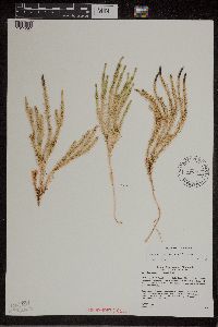 Lycopodium canadense NULL 489162[1311297]Gerdes, Lynden 48432004-06-22 United States, Minnesota, Lake, Approximately 13.76 miles NNE of Isabella, MN and 1.10 mile N of Silver Island Lake. Small, open poor conifer swamp/fen just south of FR 356. SESE of section;Superior National Forest;061N;07W;13, 47.74919 -91.135248 |
MIN:Plants | 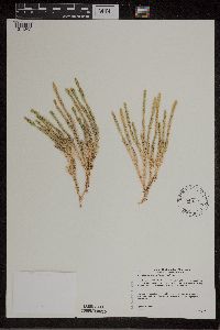 Lycopodium canadense NULL 493607[1311302]Gerdes, Lynden 49082004-08-12 United States, Minnesota, Lake, Approximately 13.3 miles NE of Isabella, MN and 0.07 mile west of an unnamed lake along Fool's Hen Creek. SWSEN [sic] of section;Superior National Forest;061N;07W;14, 47.424316 -91.446357 |
MIN:Plants | 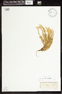 Lycopodium canadense Nessel 508179[1341450]Anonymous s.n.1938-00-00 United States, Wisconsin, Ashland, Madeline Is.;Apostle Islands National Lakeshore;;;, 46.963491 -90.660423 |
MIN:Plants | 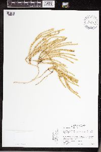 Lycopodium canadense NULL 438842[1339816]Gerdes, Lynden 50772005-09-08 United States, Minnesota, Lake, Superior National Forest. SW of Isabella, MN. Approximately 0.12 miles east of Source Lake. SWSENW of section Source Lake.. 058N 10W 25, 47.480941 -91.550254 |
MIN:Plants |  Lycopodium canadense NULL 921764[1339825]Perry, Ethan 100422010-07-20 United States, Minnesota, Saint Louis, 4.75 miles SE of Bassett Lake and 0.5 miles SW of Kylen Lake. SE1/4 of SE1/4 of section;Superior National Forest;056N;12W;14, 47.3302778 -91.8163889 |
Google Map
Google Maps is a web mapping service provided by Google that features a map that users can pan (by dragging the mouse) and zoom (by using the mouse wheel). Collection points are displayed as colored markers that when clicked on, displays the full information for that collection. When multiple species are queried (separated by semi-colons), different colored markers denote each individual species.