University of Minnesota
http://www.umn.edu/
612-625-5000
http://www.umn.edu/
612-625-5000
Minnesota Biodiversity Atlas
Bell Museum
Dataset: MIN-Plants
Taxa: Brassicaceae
Search Criteria: excluding cultivated/captive occurrences
Bell Museum plants | |
 MIN:Plants |  Nasturtium officinale W.T. Aiton 120463[1134406]Manning, Sara; et al. s.n.1898-06-27 United States, Minnesota, Wabasha, Lake City;;111N;12W;04, 44.447017 -92.258983 |
MIN:Plants |  Nasturtium officinale W.T. Aiton 120464[1134408]Burglehaus, F. s.n.1890-09-16 United States, Minnesota, Hennepin, [no further data];;;;, 45 -93.47 |
MIN:Plants |  Nasturtium officinale W.T. Aiton 120465[1134407]Manning, Sara s.n.1884-06-21 United States, Minnesota, Wabasha, Lake City;;111N;12W;04, 44.447017 -92.258983 |
MIN:Plants |  Nasturtium officinale W.T. Aiton 120466[1134410]Oestlund, O. s.n.1886-07-00 United States, Minnesota, Hennepin, Minneapolis;;029N;24W;25, 44.96996 -93.23702 |
MIN:Plants |  Nasturtium officinale W.T. Aiton 120470[1134401]Ballard, C. B 6081891-07-00 United States, Minnesota, Carver, Chaska;;116N;23W;34, 44.78944 -93.60194 |
MIN:Plants |  Nasturtium officinale W.T. Aiton 120472[1134411]Juni, B. J174 United States, Minnesota, [no data];;;;, 46 -94 |
MIN:Plants |  Nasturtium officinale W.T. Aiton 120473[1134409]Sandberg, John s.n.1879-08-00 United States, Minnesota, Hennepin, [no further data];;;;, 45 -93.47 |
MIN:Plants |  Nasturtium officinale W.T. Aiton 120474[1134397]Lyon, H. 891899-06-12 United States, Minnesota, Houston, Winnebago Valley;Dorer Memorial Hardwood State Forest;;;, 43.66667 -91.50056 |
MIN:Plants | 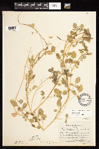 Nasturtium officinale W.T. Aiton 120475[1134396]Aiton, G. s.n.1889-08-00 United States, Minnesota, Hennepin, [no further data];;;;, 45 -93.47 |
MIN:Plants | 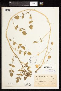 Nasturtium officinale W.T. Aiton 120476[1134412]Kassube, J. s.n.1878-05-00 United States, Minnesota, Hennepin, Minneapolis;;029N;24W;25, 44.96996 -93.23702 |
MIN:Plants | 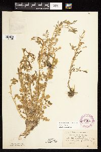 Nasturtium officinale W.T. Aiton 263945[1134405]Holzinger, John s.n. United States, Minnesota, Winona, Lake Winona;;107N;07W;00, 44.052588 -91.672687 |
MIN:Plants | 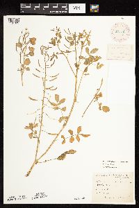 Nasturtium officinale W.T. Aiton 277783[1134395]Roberts, Thomas s.n.1884-07-19 United States, Minnesota, Hennepin, Minnehaha Falls.;Minnehaha Falls Park;028N;23W;17, 44.911796 -93.203433 |
MIN:Plants |  Nasturtium officinale W.T. Aiton 350201[1134399]McCartney, James 571938-07-07 United States, Minnesota, Scott, Minn. River between s.t.h. [highway] #50 and Savage Scott County;;;;, 44.78852 -93.35306 |
MIN:Plants |  Nasturtium officinale W.T. Aiton 373836[1134400]Moore, John; et al. 151131941-09-19 United States, Minnesota, Dakota, Railroad near Nicols, Dakota County;;027N;23W;18, 44.825884 -93.216999 |
MIN:Plants |  Nasturtium officinale W.T. Aiton 439567[1134372]Myhre, K. 31131992-08-17 United States, Minnesota, Cass, Cass County...Located NE of the Crow Wing River and Crow Wing State Park...T133N R29W NW1/4 of NW1/4 of Sec 33;;133N;29W;33, 46.287587 -94.346731 |
MIN:Plants |  Nasturtium officinale W.T. Aiton 459445[1134373]Smith, Welby 129791987-06-16 United States, Minnesota, Washington, Washington County...on the E side of Highway 4, about 1/2 mi NW of Marine on St. Croix; about 150 feet above the floodplain of the St. Croix River...SW1/4 NE1/4 sec.1, T31N R20W. 031N 20W 1, 45.2061111 -92.7797222 |
MIN:Plants |  Nasturtium officinale W.T. Aiton 508691[1134378]Lee, Michael MDL10891995-07-14 United States, Minnesota, Wabasha, Wabasha County...West Indian Creek 5 mi NNE of Plainview...T109N R11W SWNWNE 21;Dorer Memorial Hardwood State Forest;109N;11W;21, 44.229393 -92.13969 |
MIN:Plants |  Nasturtium officinale W.T. Aiton 515981[1134375]Smith, Welby 131531987-06-26 United States, Minnesota, Washington, Saint Croix National Riverway. Washington County ... in the St. Croix Valley, about 2 mi south of Marine on St. Croix ... NW1/4 SE1/4 sec. 18 T 31N R 19W. 031N 19W 18, 45.1730556 -92.7625 |
MIN:Plants |  Nasturtium officinale W.T. Aiton 536285[1134404]Aiton, G. s.n.1890-07-00 United States, Minnesota, Suburbs [assuming of Minneapolis];;;;, 44.979965 -93.263836 |
MIN:Plants |  Nasturtium officinale W.T. Aiton 560707[1134393]Ownbey, Gerald; Ownbey, Findley 22821955-07-14 United States, Minnesota, Hubbard, 6.6. mi. E of Lake George, Hwy. 71 Kabekona Creek.;;144N;33W;33, 47.245807 -94.866017 |
MIN:Plants | 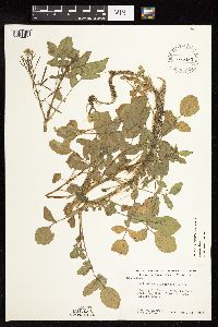 Nasturtium officinale W.T. Aiton 585480[1134403]Moore, John; et al. 261281962-07-24 United States, Minnesota, Anoka, Anoka County...Cedar Creek, N.W.1/4 Sect. 33, Cedar Creek Natural History Area.;Cedar Creek National History Area;034N;23W;33, 45.392178 -93.213974 |
MIN:Plants | 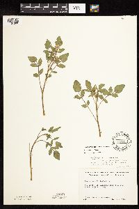 Nasturtium officinale W.T. Aiton 592217[1134398]Westkaemper, Remberta s.n.1964-06-00 United States, Minnesota, Stearns, St. Cloud. St. Cloud Hospital river bank;;124N;28W;12, 45.560451 -94.154376 |
MIN:Plants | 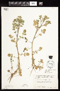 Nasturtium officinale W.T. Aiton 603678[1134414]Moore, John; et al. 268831966-06-14 United States, Minnesota, Houston, Houston County....3 mi north west of Freeburg;Dorer Memorial Hardwood State Forest;102N;05W;24, 43.623103 -91.382423 |
MIN:Plants | 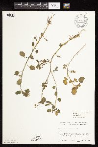 Nasturtium officinale W.T. Aiton 672622[1134388]Wheeler, Gerald s.n.1972-07-19 United States, Minnesota, Stearns, 1 mi east of Kimball...about 1/4 mi north of Hwy. 55.;;121N;29W;02, 45.3196 -94.292314 |
MIN:Plants |  Nasturtium officinale W.T. Aiton 696542[1134387]Smith, Welby 7601978-08-03 United States, Minnesota, Wright, S.W. side of Clearwater Lake. SW1/4 of section;;121N;27W;07, 45.304539 -94.127449 |
MIN:Plants |  Nasturtium officinale W.T. Aiton 708304[1134381_1;1134381_2]Ownbey, Gerald 63481979-08-10 United States, Minnesota, Winona, Along Bear Creek, 1 mi. W of jct. with Bear Creek rte. to Altura (unnumbered) with Rte 27, also to Altura. Bear Creek. SW1/4 of section;Dorer Memorial Hardwood State Forest;107N;09W;14, 44.071424 -91.869216 |
MIN:Plants |  Nasturtium officinale W.T. Aiton 728601[1134382]Eikum, B. 271979-05-16 United States, Minnesota, Dakota, Hastings, Sec. 23, 34, 35;Hastings Scientific Natural Area;115N;17W;00, 44.739075 -92.862655 |
MIN:Plants |  Nasturtium officinale W.T. Aiton 763759[1134402]Burglehaus, F. s.n.1891-09-00 United States, Minnesota, Hennepin, Minneapolis;;029N;24W;25, 44.96996 -93.23702 |
MIN:Plants |  Nasturtium officinale W.T. Aiton 770097[1134386]Smith, Welby 77821983-06-02 United States, Minnesota, Le Sueur, In the Minnesota Valley, about 2 mi east of St. Peter. NW1/4 SE1/4 of Section;Ottawa Wildlife Management Area;110N;26W;14, 44.333847 -93.919081 |
MIN:Plants |  Nasturtium officinale W.T. Aiton 782403[1134389]Tenney, M. 1721982-06-07 United States, Minnesota, Winona, NW1/4 NW1/4 NE1/4 of section;Whitewater State Park;107N;10W;29, 44.042035 -92.049333 |
MIN:Plants |  Nasturtium officinale W.T. Aiton 782748[1134394]Tenney, M. 2691982-06-23 United States, Minnesota, Fillmore, Forestville State Park. Fillmore County...T102N, R12W, Sec. 12 SW1/4 SE1/4 NW1/4;Forestville State Park;102N;12W;12, 43.652157 -92.219233 |
MIN:Plants |  Nasturtium officinale W.T. Aiton 828412[1134374]Delaney, B. 901151990-07-04 United States, Minnesota, Chisago, Chisago County...2.5 mi SW of the bridge at Osceola. SE1/4 SE1/4 sec.31, T33N, R19W;;033N;19W;31, 45.303369 -92.763498 |
MIN:Plants |  Nasturtium officinale W.T. Aiton 829545[1134376]Boe, J. 920609081992-06-09 United States, Minnesota, Roseau, Roseau County...Beltrami Island State Forest...off Tangnes Forest Road...NW1/4 NW1/4 Sec.23 T161N R36W.;Beltrami Island State Forest;161N;36W;23, 48.74928 -95.253943 |
MIN:Plants |  Nasturtium officinale W.T. Aiton 840589[1134377]Smith, Welby 181041990-08-28 United States, Minnesota, Carver, Raquet Wildlife Management Area. Carver Co. ... At the base of a south-facing bluff in the Minnesota River Valley, about 2 mi northwest of Shakopee ... T116N R23W NE1/4 of SW1/4 of Sec 35. 116N 23W 35, 44.8111111 -93.5575 |
MIN:Plants |  Nasturtium officinale W.T. Aiton 841647[1134379]Smith, Welby 133791987-07-07 United States, Minnesota, Washington, Falls Creek Scientific Natural Area. Washington County...About 2 mi NE of Scandia...stream that drains E into the St. Croix River. SE1/4 SE1/4 SW1/4 sec.7, T 32N R 19W. 032N 19W 7, 45.273759 -92.765475 |
MIN:Plants |  Nasturtium officinale W.T. Aiton 842040[1134380]Smith, Welby 150001988-08-30 United States, Minnesota, Washington, Saint Croix National Riverway. Washington County ... About 1/4 mi NE of Stillwater ... W bank of the St. Croix River ... SW1/4 SW1/4 sec.15, T30N R20W. 030N 20W 15, 45.0805556 -92.7983333 |
MIN:Plants |  Nasturtium officinale W.T. Aiton 920817[1134391]Smith, Welby 175521990-07-31 United States, Minnesota, Morrison, At Sylvan Dam on the Crow Wing River. UTM: 393900E 5128500N. SW1/4 of NE1/4 of Sec.;Camp Ripley Military Reservation;133N;29W;30, 46.3036111 -94.3777778 |
MIN:Plants |  Nasturtium officinale W.T. Aiton 438452[1134413]Smith, Welby 256131995-05-16 United States, Minnesota, Lyon, Lyon County...In Camden State Park, about 10 miles southwest of Marshall...T 110N R 42W NE1/4 of SE1/4 of Sec 5;Camden State Park;110N;42W;05, 44.36 -95.9172222 |
MIN:Plants |  Nasturtium officinale W.T. Aiton 923925[1134390]BioBlitz volunteers s.n.2011-06-11 United States, Minnesota, Dakota, Inver Grove Heights, Macalester College's Katherine Ordway Natural History Study Area.;;027N;22W;22, 44.81187 -93.03436 |
MIN:Plants |  Nasturtium officinale W.T. Aiton 966836[1359481]Anderson, Derek S. 28392019-05-14 United States, Minnesota, Chisago, Lawrence Creek SNA. About 750m north of Franconia. In creek valley, about 560m southwest of parking area., 45.38 -92.69 |
MIN:Plants |  Nasturtium officinale W.T. Aiton 973374[1398927]Lee, Michael MDL58182012-05-07 United States, Minnesota, Dakota, Ordway Field Station, Macalester College; Along the Mississippi River at River Lake, Inver Grove Heights., 44.808628143 -93.0217382458, 210m |
MIN:Plants | Nasturtium officinale W.T. Aiton []Timothy J. S. Whitfeld 35202023-05-10 United States, Minnesota, Washington, Crystal Spring Scientific and Natural Area, 0.4 miles northeast of the intersection of Scandia Trail North and Hwy 95, 45.25575 -92.764608, 241m |
MIN:Plants | Nasturtium officinale W.T. Aiton []Kerstin Griffin 741964-05-29 United States, Minnesota, Dakota, Along railroad at Nichols. Found in stream on one side of railroad. Floating out in the water about 30cm deep., 44.825447 -93.221303 |
MIN:Plants |  Nasturtium officinale W.T. Aiton 976376[1403132]Dunevitz, Hannah L. 4401991-07-23 United States, Minnesota, Winona, Area known as Ruprecht's Valley, at the base of an east-facing cliff located 3 miles north of Lewiston., 44.03 -91.87 |
MIN:Plants |  Nasturtium officinale W.T. Aiton 977197[1402780]Lee, Michael MDL62182013-06-11 United States, Minnesota, Pine, Banning State Park. Along the Kettle River just north of the Highway 123 bridge at Sandstone., 46.13176691 -92.85562142, 293m |
MIN:Plants | Lyrocarpa coulteri Hooker & Harvey 480513[]Parker, K. 79141952-04-16 United States, Arizona, Pima, near Dripping Springs...Puerto Blanco Mountains, Organ Pipe Cactus National Monument; Sonoran Desert...Pima County;Organ Pipe Cactus National Monument, 610m |
MIN:Plants | 234258[]Congdon, J. s.n.1896-10-04 United States, California, Mariposa, Wawona;Yosemite National Park;;;, 37.53694 -119.65528 |
MIN:Plants | 234260[]Congdon, J. s.n.1883-06-03 United States, California, Mariposa, Yosemite Valley;Yosemite National Park;;;, 37.71639 -119.66417 |
MIN:Plants | Draba juvenilis Komarov 403575[]Spetzman, L. 9071948-07-29 United States, Alaska, Arctic North Slope...Sadlerochit River;Arctic National Wildlife Refuge;;;, 69.4166667 -149.1666667, 762m |
MIN:Plants | Draba juvenilis Komarov 403534[]Spetzman, L. 8441948-07-26 United States, Alaska, Arctic North Slope...Sadlerochit River;Arctic National Wildlife Refuge;;;, 69.4166667 -149.1666667, 762m |
MIN:Plants | Draba juvenilis Komarov 298363[]Mexia, Ynes 20441928-06-25 United States, Alaska, McKinley National Park...Head of Savage River;Denali National Park;;;, 63.918056 -149.495278, 1000m |
MIN:Plants | Draba juvenilis Komarov 403355[]Spetzman, L. 12931948-07-08 United States, Alaska, Arctic North Slope ... Lake Schrader;Arctic National Wildlife Refuge;;;, 69.4166667 -145, 914m |
MIN:Plants |  461823[1356016]Kaul, R. 53471986-07-29 United States, Minnesota, Steele, Steele Co.; above the Straight River, Owatonna.;;107N;20W;, 44.066112 -93.226071 |
MIN:Plants |  919544[1391764]Smith, Welby 222791993-06-03 United States, Minnesota, Sibley, Vale Wildlife Management Area. Sibley County ... Vale State Wildlife Management Area; in the valley of High Island Creek, about 2.5 miles southwest of its confluence with the Minnesota River ... T113N R26W NE1/4 of SW1/4 of Sec 27. 113N 26W 27, 44.5625 -93.9427778 |
MIN:Plants |  461875[1391793]Kaul, R. 50561985-05-26 United States, Minnesota, Steele, Steele Co.; along Straight River, southwest edge of Owatonna.;;107N;20W;, 44.066112 -93.226071 |
MIN:Plants |  431782[1391814]Smith, Welby 166961990-05-29 United States, Minnesota, Dodge, Dodge County...About 3 miles northwest of Byron...slope overlooking the South Branch Middle Fork Zumbro River... T 107N R 16W NE1/4 of SW1/4 of Sec. 13. 107N 16W 13, 44.0708351 -92.6858368 |
MIN:Plants |  714511[1391824]Ahles, H. 664031967-06-09 United States, New York, Dutchess, Dutchess Co, East Park, Ahles property on Nub Street. |
MIN:Plants |  461960[1356012]Juhnke, C. 264 CMJ FRO1999-05-21 United States, Minnesota, Goodhue, Frontenac State Park Goodhue County ... Along Cty. Rd. 2...100 meters southwest of park entrance..T112N R13W SW SW NW 11;Frontenac State Park;112N;13W;11, 44.51999 -92.339224 |
MIN:Plants |  905509[1391797]Cholewa, A. 26052008-06-09 United States, Minnesota, Ramsey, Ramsey County, Mounds View, approx. 1/4 mile NW of County Highway H on County Highway 10 (near Scout Store). T30N R23W Sec 8, SE1/4. 030N 23W 8, 45.100763 -93.198544 |
MIN:Plants |  119511[1391787]Kassube, J. s.n.1878-06-00 United States, Minnesota, Hennepin, Minneapolis;;N;;, 44.979965 -93.263836 |
MIN:Plants |  119513[1391775]Moyer, Lycurgus s.n.1885-06-00 United States, Minnesota, Chippewa, Montevideo;;117N;40W;, 44.934626 -95.675774 |
MIN:Plants |  360465[1391802]Moyle, J. 36511940-06-23 United States, Minnesota, Lake, near Two Harbors;;N;;, 47.022711 -91.670732 |
MIN:Plants |  381155[1391805]Rosendahl, C.; et al. 75901942-06-17 United States, Minnesota, Winona, Fence corner, Schulz's yard, 2 mi N of Utica;, 44.004486 -91.954879 |
MIN:Plants |  420778[1391799]Lakela, Olga 105561950-06-29 United States, Minnesota, Saint Louis, Congdon River terrace, Duluth;;N;;, 46.82178 -92.06745 |
MIN:Plants |  429862[1356017]Smith, Welby 153761989-06-14 United States, Minnesota, Chisago, Chisago County...In the St. Croix Valley, about 5 miles south-southwest of Taylors Falls...NW1/4 NW1/4 section 2, T 33N R 19W. 033N 19W 22, 45.3283348 -92.7125015 |
MIN:Plants |  443767[1391769]Husveth, J. 96-0821986-06-18 United States, Minnesota, Goodhue, Goodhue Co. T113N R16W NE1/4 of the SW1/4 of S25; bank of the Cannon River.;Dorer Memorial Hardwood State Forest;113N;16W;25, 44.564651 -92.562251 |
MIN:Plants |  446431[1391772]Moore, John; et al. 173831945-06-21 United States, Minnesota, Pennington, Pennington County...1 mi SE of Thief River Falls;;;;, 48.122984 -96.171962 |
MIN:Plants |  449297[1391780]Moore, John; Huff, N. 178951945-07-24 United States, Minnesota, Morrison, at Randall;;N;;, 46.091077 -94.50362 |
MIN:Plants |  475776[1356020]Smith, Welby 206871992-07-08 United States, Minnesota, Goodhue, Dorer Memorial Hardwood State Forest. Goodhue Co.; About 3 miles west of Red Wing; north-facing bluff in the Cannon River Valley; Cannon Valley Trail; erc Goodhue Co.; About 3 miles west of Red Wing; north-facing bluff in the Cannon River Valley; Cannon Valley Trail; T 113N R 15W SW1/4 of SE1/4 of sec 21. 113N 15W 21, 44.5738907 -92.6194458 |
MIN:Plants |  488762[1391778]Moore, John 200411949-06-01 United States, Minnesota, Otter Tail, adjacent to Big Pine Lake;;N;;, 46.609302 -95.4955 |
MIN:Plants |  494325[1391777]Huff, N. s.n.1941-06-08 United States, Minnesota, Hennepin, Minneapolis;;N;;, 44.979965 -93.263836 |
MIN:Plants |  516069[1356018]Myhre, K. 38311993-06-14 United States, Minnesota, Pine, Pine Co.; located 1 mi SW of Tamarack Lake; T41N R17W NE1/4 of SE1/4 of Sec 6;;041N;17W;6, 46.062809 -92.541241 |
MIN:Plants |  519859[1356019]Smith, Welby 210871992-07-23 United States, Minnesota, Le Sueur, Le Sueur Co.; about 1 mi E of Elysian, on the N side of Highway 60. In abandoned gravel pit; Le Sueur Co.; about 1 mi E of Elysian, on the N side of Highway 60. In abandoned gravel pit; T109N R23W SW1/4 of SW1/4 of Sec 31. 109N 23W 31, 44.1983337 -93.6436081 |
MIN:Plants |  552116[1391811]Stevens, O. 19451958-06-20 United States, Minnesota, Clay, Moorhead; N;, 46.845648 -96.728846 |
MIN:Plants |  554291[1391776]Moore, John 231971957-06-14 United States, Minnesota, Pipestone, Pipestone Co.; at Pipestone;;106N;46W;, 43.979723 -96.367859 |
MIN:Plants |  558230[1391821]Moore, John 238271958-06-11 United States, Minnesota, Kittson, Along the Red River 1 mi S of Robbin;;N;;, 48.55829 -97.14257 |
MIN:Plants |  564496[1391807]Rhone, R. s.n.1940-07-15 United States, Minnesota, Ramsey, Montreal & Cleveland, St. Paul. Ramsey Co.;;028N;23W;, 44.905162 -93.166462 |
MIN:Plants |  572731[1391806]Moore, John 253811961-06-06 United States, Minnesota, Houston, at Reno;102N;04W;, 43.62916 -91.318526 |
MIN:Plants |  574567[1391804]Moore, John 246351959-06-17 United States, Minnesota, Pipestone, Pipestone Co.; 2 miles east of Pipestone; 106N;45W;, 43.979365 -96.246045 |
MIN:Plants |  574687[1391820]Moore, John 247611959-07-31 United States, Minnesota, Kittson, Roadside at Hallock;;N;;, 48.774426 -96.946447 |
MIN:Plants |  574721[1391809]Moore, John 246091959-06-05 United States, Minnesota, Blue Earth, N shore of Madison Lake; N;, 44.239469 -93.828345 |
MIN:Plants |  592231[1391798]Westkaemper, Remberta s.n.1963-06-00 United States, Minnesota, Stearns, Stearns Co. St. Benedict's [College] woods.;;124N;29W;, 45.543642 -94.322053 |
MIN:Plants |  603611[1391789]Moore, John; Moore, Marjorie 268761966-06-10 United States, Minnesota, Isanti, near the Cornea Cabin, Cedar Creek Natural History Area.;Cedar Creek National History Area;034N;23W;, 45.428063 -93.203997 |
MIN:Plants |  603978[1391810]Moore, John; Moore, Marjorie 268851966-06-14 United States, Minnesota, Houston, SE1/4 Sec.24 Crooked Creek Twp.; 102N;04W;24, 43.623144 -91.270541 |
MIN:Plants |  611343[1391785]Hsi, Yu-tseng [Eugene] 9521969-06-19 United States, Minnesota, Lyon, State conservation area ca. 1 1/2 mi sw of Camden State Park.;;N;;, 44.347099 -95.946511 |
MIN:Plants |  623140[1391808]Moore, John; et al. 273401970-06-08 United States, Minnesota, Anoka, Anoka County...at east farmstead, Cedar Creek Natural History Area; SE1/4 Sec.34 Bethel Twp.;Cedar Creek National History Area;034N;23W;34, 45.392319 -93.193505 |
MIN:Plants |  645918[1391801]Westkaemper, Remberta s.n.1965-05-00 United States, Minnesota, Stearns, Stearns Co. Roscoe;;N;;, 45.433853 -94.639725 |
MIN:Plants |  657138[1391815]Scanlan, M. 0701973-07-18 United States, Minnesota, Swift, Swift Co. Collected in SW-233, 3-acre woodlot; T122N R42W Sec. 28;;122N;42W;28, 45.347692 -95.942444 |
MIN:Plants |  657139[1391819]Scanlan, M. 0691973-08-02 United States, Minnesota, Big Stone, Collected in BI-246, woodlot on the N shore of Otrey L.; T122N R45W Sec. 29;;122N;45W;29, 45.348141 -96.333414 |
MIN:Plants |  657151[1391817]Scanlan, M. 0721973-08-07 United States, Minnesota, Swift, Swift Co. Collected in SW-254, a 4-acre woodlot; T122N R37W Sec. 25;;122N;37W;25, 45.347721 -95.265571 |
MIN:Plants |  657152[1391816]Scanlan, M. 0731973-07-06 United States, Minnesota, Swift, Swift Co. Collected in SW-210; Sec. 26 T122N R43W;;122N;43W;26, 45.347809 -96.025074 |
MIN:Plants |  657168[1391790]Scanlan, M. 711973-08-07 United States, Minnesota, Swift, Swift Co. in SW-257 (Sec.20 T122N R37W) a 4-acre woodlot that dates from the drought of the 1930's.;;122N;37W;20, 45.361789 -95.347777 |
MIN:Plants |  691033[1391818]Sperling, C. 1291976-05-25 United States, Minnesota, Douglas, 2.5 mi W, 3 mi S of Holmes City;;N;;, 45.790122 -95.593107 |
MIN:Plants |  696539[1391788]Smith, Welby 7571978-05-29 United States, Minnesota, Wright, Wright Co.; 1/4 mi SW of North Lake. T122N R26W SW1/4 sec.35.;;122N;26W;35, 45.333233 -93.921505 |
MIN:Plants |  708444[1391779]Tenney, M. 3901982-07-07 United States, Minnesota, Fillmore, Forestville State Park. Fillmore Co. T102N R12W Sec.13 NW1/4 SW1/4 NE1/4.;Forestville State Park;102N;12W;13, 43.637724 -92.219269 |
MIN:Plants |  711397[1391800]Smith, Welby 9731979-06-12 United States, Minnesota, Winona, Winona co. White Water River. T106N R10W NW1/4 SW1/4 sec.1.;;106N;10W;1, 44.013261 -91.969183 |
MIN:Plants |  721151[1391803]Lustig, K. 4611979-06-13 United States, Minnesota, Sherburne, Clear Lake-Mississippi Scenic and Recreational River, SNA: 12 mi se of St. Cloud, Sec.14, 22,23, T34N R30W.;Clear Lake Scientific Natural Area;034N;30W;, 45.446339 -94.043783 |
MIN:Plants |  727655[1391774]Lustig, K. 4411979-06-08 United States, Minnesota, Sherburne, Mississippi River Islands Scientific Natural Area. Sherburne & Wright Cos. ...Mississippi Scenic and Recreational River Islands SNA: Mississippi River Islands between Monticello and Elk River. sec. 2, 3, 4, T32N, R26, 27W; sec. 7, 9, 18, T121N, R23, 24W. 032N 26W 3, 45.293483 -93.556246 |
MIN:Plants | 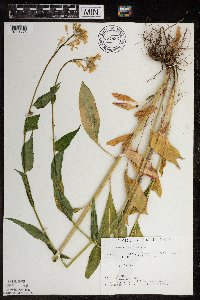 727892[1391773]Eikum, B. 641979-06-03 United States, Minnesota, Dakota, Hastings;Hastings Scientific Natural Area;115N;17W;, 44.73907 -92.86266 |
MIN:Plants | 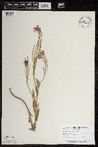 770626[1391768]Smith, Welby 84701983-07-27 United States, Minnesota, Mower, about 3 mi ne of Lyle. NW1/4 NE1/4 sec.29 T101N R17W.;;101N;17W;29, 43.521501 -92.898529 |
Google Map
Google Maps is a web mapping service provided by Google that features a map that users can pan (by dragging the mouse) and zoom (by using the mouse wheel). Collection points are displayed as colored markers that when clicked on, displays the full information for that collection. When multiple species are queried (separated by semi-colons), different colored markers denote each individual species.