University of Minnesota
http://www.umn.edu/
612-625-5000
http://www.umn.edu/
612-625-5000
Minnesota Biodiversity Atlas
Bell Museum
Dataset: MIN-Plants
Taxa: Brassicaceae
Search Criteria: excluding cultivated/captive occurrences
Bell Museum plants | |
 MIN:Plants |  782335[1391794]Tenney, M. 3901982-07-07 United States, Minnesota, Fillmore, Forestville State Park. Fillmore Co. T102N R12W Sec.13 NW1/4 SW1/4 NE1/4.;Forestville State Park;102N;212;13, 43.637724 -92.219269 |
MIN:Plants |  795703[1391792]Bender, J. s.n.1986-05-20 United States, Minnesota, Washington, Along sides of roads at Belwin; Afton Twp.;;028N;20W;, 44.907173 -92.81202 |
MIN:Plants |  799195[1391771]Almendinger, J. s.n.1987-05-15 United States, Minnesota, Washington, Washington Co. MCBS-#7, Hastings, in ravine, 1 mi NW Lock and Dam 2; T27N R21W SE1/4 SW1/4 Sec. 36;;027N;21W;36, 44.782851 -92.87307 |
MIN:Plants |  802741[1391795]Smith, Welby 114981986-05-24 United States, Minnesota, Scott, Minnesota Valley National Wildlife Refuge. Scott County...The Louisville Swamp area, in the Minnesota Valley National Wildlife Refuge, about 6 mi S of Shakopee; NW1/4 SE1/4 Sec. 29 T115N R23W. 115N 23W 29, 44.7355556 -93.5988889 |
MIN:Plants |  805829[1356021]Almendinger, J. s.n.1988-06-27 United States, Minnesota, Washington, Greenburg Island, O'Brien State Park, Marine on St. Croix, center of Greenburg Island; T32N R19W NE1/4 SE1/4 Sec. 31;William O'Brien State Park;032N;19W;31, 45.217153 -92.76414 |
MIN:Plants |  814631[1391786]Wheeler, Gerald 113791988-07-25 United States, Minnesota, Lac Qui Parle, Lac Qui Parle State Park. Ca. 15 mi E of Madison, Lac Qui Parle State Park, N of rte 33, along Lac Qui Parle River; N1/2 NE1/4 Sec. 23 T118N R42W Ca. 15 mi E of Madison, Lac Qui Parle State Park, N of rte 33, along Lac Qui Parle River; N1/2 NE1/4 Sec. 23 T118N R42W (Lac Qui Parle Twp.). 118N 42W 23, 45.015157 -95.888871 |
MIN:Plants |  814769[1391791]Wheeler, Gerald 105301988-05-27 United States, Minnesota, Norman, Ca. 1 mi W of Halstad, roadside park S of rte 200; W1/2 NE1/4 Sec. 25 T145N R49W (Halstad Twp.);;145N;49W;25, 47.347671 -96.840153 |
MIN:Plants |  431702[1391767]Smith, Welby 166681990-05-21 United States, Minnesota, Waseca, Goose Lake County Park. Waseca County ... Goose Lake County Park; at the southwest end of Goose Lake, about 2 miles east of Waseca ... T107N R22W NW1/4 of SW1/4 of Sec 14. 107N 22W 14, 44.0705566 -93.4436111 |
MIN:Plants |  493104[1391766]Bosch, T. 122001-05-25 United States, Minnesota, Big Stone, Approx. 0.5 mile east of Hwy. 75 and 2 miles south of Hwy. 7.;;120N;45W;01, 45.2325 -96.236536 |
MIN:Plants |  477552[1391796]Smith, Welby 206161992-06-25 United States, Minnesota, Redwood, Redwood County...In Alaexander Ramsey city park in Redwood Falls; steep wooded slopes in the Redwood River Valley... T113N R36W NW1/4 of SE1/4 of Sec 36. 113N 36W 36, 44.5480537 -95.1244431 |
MIN:Plants |  499004[1356015]Whitfeld, T.J.S. 3312002-05-29 United States, Minnesota, Pope, Pope County ... 8 miles southeast of Glenwood; between Swenoda Lake and County Rd. 23 ... T124N R37W SESE21;;124N;37W;21, 45.535066 -95.326837 |
MIN:Plants |  906100[1356013]Corcoran, R. 0392008-10-09 United States, Minnesota, Ramsey, Ramsey Co. Grove Park, west-end of soccer field, Northwest of University of Minnesota St Paul campus, south of Larpenteur Ave W, west of Cleveland Ave N. 029N 23W 20, 44.99 -93.1894444 |
MIN:Plants |  919296[1391762]Cholewa, A. 27112010-05-18 United States, Minnesota, Pipestone, Pipestone County, between farmstead and Split Rock Creek State Park, along County Road 20. T105N R46W S15 near center west line. 105N 46W 15, 43.899838 -96.357127 |
MIN:Plants |  453718[1356014]Coulter, M. 15781999-05-28 United States, Minnesota, Sherburne, Sherburne National Wildlife Refuge; SWNW 27-35-27;Sherburne National Wildlife Refuge;035N;27W;27, 45.494037 -93.685104 |
MIN:Plants |  622740[1391823]Coiteux, Louis-Philippe 66-1581966-07-12 Canada, Quebec, Province de Quebec ... Sherbrooke |
MIN:Plants |  477770[1391765]Smith, Welby 174221990-07-23 United States, Minnesota, Steele, Steele County ... Kaplan Woods City Park, on the south side of Owatonna ... on the north side of the Straight River ... T 107N R 20W NE1/4 of NW1/4 of Sec 21. 107N 20W 21, 44.0644455 -93.2350006 |
MIN:Plants |  918246[1391763]Smith, Welby 224331993-06-18 United States, Minnesota, Grant, Grant County ... On the south side of Ask Lake, about 1.5 miles east-southeast of Ashby ...T130N R41W NW1/4 of SW1/4 of Sec 12. 130N 41W 12, 46.0847222 -95.7886111 |
MIN:Plants |  923923[1391761]BioBlitz volunteers s.n.2011-06-11 United States, Minnesota, Dakota, Inver Grove Heights, Macalester College's Katherine Ordway Natural History Study Area.;;027N;22W;22, 44.81187 -93.03436 |
MIN:Plants |  926396[1391760]Schimpf, D. DJS6372011-07-24 United States, Minnesota, Saint Louis, Duluth. Above Glen Place Drive.;;050N;14W;33, 46.7759722 -92.1129167 |
MIN:Plants |  926673[1391759]Schimpf, D. DJS6352011-07-21 United States, Minnesota, Saint Louis, Duluth. Just below Buckingham Creek's entry to tunnel.;;50N;14W;33, 46.7755556 -92.1131944 |
MIN:Plants |  922590[1391813]Smith, Welby 237501993-08-27 United States, Minnesota, McLeod, Lake Marion County Park. Lake Marion County Park; on the south side of Lake Marion, about 6 miles south of Hutchinson... T 115N R 30W NE1/4 of NE1/4 of Sec 12. 115N 30W 12, 44.7877778 -94.3811111 |
MIN:Plants |  923166[1391812]Smith, Welby 238641993-09-05 United States, Minnesota, Wright, Between Hwy 24 and Clearwater Lake, about 2.5 mi N-NE of Annandale...T121N R27W NW1/4 of SW1/4 of Sec 9;;121N;27W;09, 45.304306 -94.086622 |
MIN:Plants |  934783[1391783]Whitfeld, T. J. S. 9212012-06-07 United States, Minnesota, Dakota, Dakota County;Hastings Scientific Natural Area;;;, 44.66667 -93.06667 |
MIN:Plants |  520126[1391782]Cholewa, A. 28442014-05-30 United States, Minnesota, Ramsey, Roseville industrial area along orthwest corner of I-35W and Hwy 36.;;;;, 45.0108 -93.1938 |
MIN:Plants |  943946[1391784]Pomroy, Deborah DLP28292014-06-04 United States, Minnesota, Saint Louis, T50N R14W NW 1/4 Sec 13. Tischer Creek & 4th St, upstream side of bridge, N-side of creek., 46.819444 -92.063333 |
MIN:Plants |  944868[1391781]Nee, M. 611572014-06-08 United States, Minnesota, Dakota, Westernmost part of Lakeville, SE side of junction of I-35 and Hwy. 70, area of gas stations and fast food restaurants, 44.643056 -93.293611, 333m |
MIN:Plants |  950859[1290179]Schimpf, David J. DJS7102013-06-29 United States, Minnesota, Saint Louis, Duluth, NW corner Superior St. & 12th Ave. E; T50N R14W SW1/4 Sec 23, 46.799028 -92.083194 |
MIN:Plants |  960964[1334047]Anderson, Derek S. 25302016-05-16 United States, Minnesota, Brown, Cottonwood River Prairie SNA, About 1.6 km east of Sanborn. On east side of the Redwood/Brown County line, in the southeast corner of the intersection of 460th Ave. and 170th St. W., 44.21 -95.11 |
MIN:Plants |  963590[1352205]Graham, Dustin R. DRJG702017-05-30 United States, Minnesota, Swift, Collection located ca. 3 km SW of Appleton, MN, on island in northern portion of Lac Qui Parle., 45.16 -96.04, 942m |
MIN:Plants |  520985[1391822]Nee, M. 621882015-05-28 United States, Wisconsin, Richland, 3.8km E of Gotham. T 9 N; R 2 E; SE1/4 SW1/4 Sect. 27, 43.219167 -90.245, 228m |
MIN:Plants |  1391825[1391825]Stevens, ? 18871950-06-09 United States, North Dakota, Sheridan, Lincoln Valley |
MIN:Plants |  577312[1391826]Bright, C.C. 60-81960-06-20 United States, Idaho, Franklin, 1 mile S of Oneida Power Plant, Bear River Narrows, Ca. 14 miles N of Preston., 1440m |
MIN:Plants |  119505[1391827]Steele, E.S. s.n.1896-05-25 United States, District of Columbia |
MIN:Plants |  250197[1391828]Brenckle, J.F. 511910-07-00 United States, North Dakota, Kulm, La Mouse County |
MIN:Plants |  355610[1391829]Barkley, Fred A. 33861938-05-14 United States, Idaho, Bannock, Just north of Inkum |
MIN:Plants |  119500[1391830]Lucy, Dr. T.F. 5391894-06-15 United States, New York, Chemung, Belmin Pine Valley and Horseheads |
MIN:Plants |  395856[1391831]Wadmond, S.C. s.n.1937-06-19 United States, Wisconsin, Rock, Along path in Big Hill Park 4 mi. no. of Beloit |
MIN:Plants |  588491[1391832]Lautenschlager, L.F. 4851963-06-25 United States, North Dakota, Ward |
MIN:Plants |  395857[1391833]Wadmond, S.C. 2091935-06-09 United States, Wisconsin, Walworth |
MIN:Plants |  604111[1391834]Radford, A.E. 454071967-06-27 United States, North Carolina, Mitchell |
MIN:Plants | 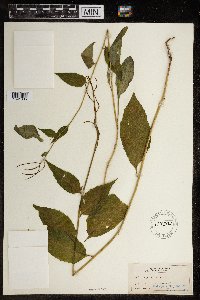 119502[1391835] s.n.1892-06-28 United States, Illinois, Abourold gardens |
MIN:Plants | 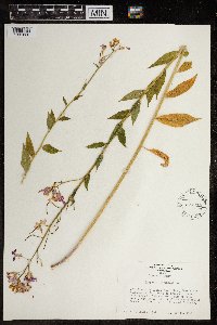 577352[1391836]Bright, C.C. 60-71960-06-20 United States, Idaho, Franklin, .75 miles S of Oneida Power Plant, Bear River Narrows, ca. 14 miles N of Preston., 1440m |
MIN:Plants | 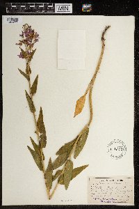 119503[1391837]Lucy, Dr. T.F. 5391894-06-15 United States, New York, Chemung, Belmin Pine Valley and Horseheads |
MIN:Plants | 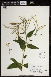 622664[1391838]Coiteux, Louis-Philippe 66-1581966-07-12 Canada, Quebec |
MIN:Plants |  606774[1391839]Bartlett, H.H. 1651952-06-24 Canada, Ontario, Thunder Bay, Along highway U.S. 61, 2 miles northeast of Pine River, Crooks Township |
MIN:Plants |  546709[1391840]Scoggan, H.J. 112461953-07-11 Canada, Manitoba, St. Lazare, west of Birtle. Road bank near garden. |
MIN:Plants |  487829[1391841]Deane, Walter s.n.1910-06-13 United States, Massachusetts, weed in Brewster Garden |
MIN:Plants |  487351[1391842]Deane, Walter s.n.1911-07-29 United States, Massachusetts, Weed in Brewster Garden |
MIN:Plants |  250332[1391843]Brenckle, J.F. 5201917-06-28 |
MIN:Plants |  361097[1391844]Hayden, Ada 96001939-05-25 United States, Iowa, Palo Alto, Highland Twp, Sec. 6. About 3 miles north of Ruthven on Loesser (Babcock) Farm. Escaped from cultivation. |
MIN:Plants |  119506[1391845]Lucy, T.F. 5391897-06-19 United States, New York, Chemung, At Pine Valley |
MIN:Plants |  119510[1391846] 62 United States, Illinois, Du page, cultivated arr. spaning(?) escaped |
MIN:Plants |  119509[1391847]Heller, A.A. s.n.1889-05-23 United States, Pennsylvania, Lancaster |
MIN:Plants |  1119508[1391848]C.F.W. s.n.1890-00-00 United States, Michigan |
MIN:Plants |  119507[1391849]Small, John K. s.n.1889-05-23 United States, Pennsylvania, Lancaster, Hill 3 miles W. Lancaster |
MIN:Plants |  487229[1391850]Churchill, J.R. s.n.1926-08-11 United States, Illinois, Cook, West shore of Lake Michigan |
MIN:Plants |  119504[1391851]Lucy, T.F. 539 2au1896-06-27 United States, New York, Chemung, Roadside near Pine Valley |
MIN:Plants |  383796[1391853]J.D.B. s.n.1900-06-00 Cambridge |
MIN:Plants |  375821[1391854]Lhatoher(?) 1031942-06-18 United States, South Dakota, Pennington, Pactola C.C.C. camp |
MIN:Plants |  119498[1391855]Eames, Edwin H. s.n.1895-06-17 United States, Connecticut |
MIN:Plants |  119499[1391856]Palmer, E.L. 5571913-06-18 United States, New York, Tompkins, Side of Ravine just below bridge at Forest Home. |
MIN:Plants |  1119501[1391857]Lucy, T.F. 5391897-06-19 United States, New York, Chemung, At Pine Valley. |
MIN:Plants |  739140[1391858]Gilly, C.L. 1201953-06-10 United States, Michigan, Ingham, City of Lansing, on bank in back yard at 648 Sunset Ln. T 4 N, R 1 W |
MIN:Plants |  766321[1391859]Lucy, T.F. 539 2au1896-06-24 United States, New York, Chemung, Roadside, near Pine Valley |
MIN:Plants |  803023[1391770]Smith, Welby R. 117881986-06-14 United States, Minnesota, Olmsted, Oxbow County Park, about 3 miles north of Byron. On the banks of the Zumbro River. NW1/4 NW1/4 section 17, T 107N R 15W, 44.076944 -92.653889 |
MIN:Plants |  119512[1391758]Wirkershium(?), W. J. 1891-06-00 United States, Minnesota, Lincoln, Lake Stay |
MIN:Plants |  973611[1397165]Bezanson, Char A. 641991-06-03 United States, Minnesota, Rice, in the Cowling Arboretum at Carleton College. West bank of the Cannon River, 44.466427 -93.15326 |
MIN:Plants | []Timothy J. S. Whitfeld 35752023-06-30 United States, Minnesota, Washington, Crystal Spring Scientific and Natural Area; 0.4 miles northeast of the intersection of Scandia Trail North and Hwy 95, 45.2601 -92.7664, 285m |
MIN:Plants | 978204[1401613]Don Henson 4551972-07-16 United States, Michigan, Schoolcraft, SW 1/4 NW 1/4 SE 1/4 Sec 14 T42N-R16W |
MIN:Plants | Draba norvegica Gunnerus 394121[1352967]Abbe, E.; Abbe, L. United States, Minnesota, Cook, Detailed locality information protected. This is typically done to protect rare or threatened species localities. |
MIN:Plants | Draba norvegica Gunnerus 538966[]Abbe, E.; Abbe, L. United States, Minnesota, Cook, Detailed locality information protected. This is typically done to protect rare or threatened species localities. |
MIN:Plants | Draba norvegica Gunnerus 725016[1293514]Berlin, Nancy L. United States, Minnesota, Cook, Detailed locality information protected. This is typically done to protect rare or threatened species localities. |
MIN:Plants | Draba norvegica Gunnerus 454445[1158298]Smith, Welby R. United States, Minnesota, Cook, Detailed locality information protected. This is typically done to protect rare or threatened species localities. |
MIN:Plants | Boechera pendulina (Greene) W. A. Weber 597151[]Holmgren, Noel; et al. 19861965-06-22 United States, Utah, Washington, Washington Co.: Zion National Park, Horse Pasture Plateau, along West Rim Trail of Zion Canyon. T.40S, R.10W, Sec.32;Zion National Park;040S;10W;32, 2225m |
MIN:Plants | Boechera pendulina (Greene) W. A. Weber 361985[]Rollins, Reed; et al. 24691938-07-08 United States, Nevada, White Pine, Near Lehman Creek, east of Mt. Wheeler, Snake Range...White Pine County.;Great Basin National Park, 2743m |
MIN:Plants | Capsella bursa-pastoris (L.) Medikus 488983[]Juhnke, C. 2891999-05-25 United States, Minnesota, Goodhue, Frontenac State Park, Goodhue County...In meadow along Cty. Rd. 2 SE of contact station...T112N R13W NW SE NW 11;Frontenac State Park;112N;13W;11, 44.51999 -92.339224 |
MIN:Plants | Capsella bursa-pastoris (L.) Medikus 910913[]Smith, Welby 219591992-09-07 United States, Minnesota, Watonwan, Watonwan County...At the west end of Long Lake, about 6 miles south-southwest of St. James...T 105N R 32W SW1/4 of SW1/4 of Sec 10. 105N 32W 10, 43.9069444 -94.6769444 |
MIN:Plants |  Capsella bursa-pastoris (L.) Medikus 461407[1352563]Gerdes, Lynden 25931998-06-03 United States, Minnesota, Cook, Boundary Waters Canoe Area Wilderness / Superior National Forest. T65N R01E S28NENE. Cook County; Superior National Forest, BWCAW, Clearwater Lake, BWCAW campsite on north side of lake and west side of small bay.. 065N 01E 28, 48.084859 -90.335202 |
MIN:Plants | Capsella bursa-pastoris (L.) Medikus 461931[]Wheeler, Gerald 163731997-06-28 United States, Minnesota, Swift, Swift County ... Ca. 10 mi. NNE of Kerkhoven; Monson Lake State Memorial Park ... N1/2 SW1/4 NW1/4 Sec. 1 T121N R37W;Monson Lake State Park;121N;37W;01, 45.318174 -95.265442 |
MIN:Plants | Capsella bursa-pastoris (L.) Medikus 454127[]Bosch, T. 22002-05-10 United States, Minnesota, Big Stone, Big Stone County ... Approx. 0.5 east of Hwy. 75 and 2 miles south of Hwy. 7 ... T120N R45W sec. 1-2;Lac Qui Parle Wildlife Management Area;120N;45W;1-2, 45.2325 -96.23654 |
MIN:Plants | Capsella bursa-pastoris (L.) Medikus 913222[]Smith, Welby 240991994-05-16 United States, Minnesota, Murray, Murray County ... Lake Shetek State Park, about 3 miles northwest of Currie ... T107N R40W SW1/4 of SW1/4 of Sec 31;Lake Shetek State Park;107N;40W;31, 44.1111111 -95.7011111 |
MIN:Plants | Capsella bursa-pastoris (L.) Medikus 493103[]Smith, Welby 157421989-07-17 United States, Minnesota, Benton, Benlacs Wildlife Management Area. Benton County ... Benlacs State Wildlife Management Area, about 7 miles SE of Foley ... SE1/4 SE1/4 section 12, T36N R 28W. 036N 28W 12, 45.625853 -93.770684 |
MIN:Plants | Capsella bursa-pastoris (L.) Medikus 918210[]Smith, Welby 223551993-06-08 United States, Minnesota, Carver, Carver County...Carver Park Reserve; about 5 miles west of Chanhassen...T 116N R 24W SE1/4 of NE1/4 of Sec 11;Carver Park Reserve County Park;116N;24W;11, 44.8716667 -93.6644444 |
MIN:Plants | Capsella bursa-pastoris (L.) Medikus 912825[]Smith, Welby 243871994-06-14 United States, Minnesota, Yellow Medicine, Upper Sioux Agency State Park. Yellow Medicine County...Upper Sioux Agency State Park; In the Minnesota Valley about seven miles southwest of Sacred Heart...T 115N R 38W SE1/4 of SE1/4 of Sec 29. 115N 38W 29, 44.735 -95.4425 |
MIN:Plants | Capsella bursa-pastoris (L.) Medikus 118044[]Skinner, S. 581902-06-10 United States, Minnesota, Jackson, Heron Lake region;;N;;, 43.760874 -95.255356 |
MIN:Plants | Capsella bursa-pastoris (L.) Medikus 118045[]Manning, Sara s.n.1883-07-14 United States, Minnesota, Wabasha, Lake City;;N;;, 44.44402 -92.273367 |
MIN:Plants | Capsella bursa-pastoris (L.) Medikus 118046[]G. & L. s.n.1885-05-00 United States, Minnesota, Chippewa, Montevideo;;117N;40W;, 44.934626 -95.675774 |
MIN:Plants | Capsella bursa-pastoris (L.) Medikus 118047[]Ballard, C. 28071901-06-04 United States, Minnesota, Clay, Moorhead;;N;;, 46.845648 -96.728846 |
MIN:Plants | Capsella bursa-pastoris (L.) Medikus 118048[]Ainslie, G. 17521902-06-26 United States, Minnesota, Olmsted, Rochester;;106N;14W;, 43.97834 -92.49834 |
MIN:Plants | Capsella bursa-pastoris (L.) Medikus 118049[]Moore, W. s.n.1907-06-02 United States, Minnesota, Ramsey, Merriam Park [St Paul neighborhood at west end of Minnehaha Ave];;029N;23W;, 44.992077 -93.166387 |
MIN:Plants | Capsella bursa-pastoris (L.) Medikus 118050[]Taylor, B. T721891-06-00 United States, Minnesota, Le Sueur, Elysian;;109N;24W;, 44.239498 -93.707142 |
MIN:Plants | Capsella bursa-pastoris (L.) Medikus 118051[]Ballard, C. 28071901-06-04 United States, Minnesota, Clay, Moorhead;;N;;, 46.845648 -96.728846 |
MIN:Plants | Capsella bursa-pastoris (L.) Medikus 118052[]Lyon, H. 1201899-06-17 United States, Minnesota, Houston, Winnebago Valley, Houston Co.;Dorer Memorial Hardwood State Forest;N;;, 43.53967 -91.40968 |
MIN:Plants | Capsella bursa-pastoris (L.) Medikus 118053[]Sandberg, John s.n.1889-06-00 United States, Minnesota, Goodhue, [no further data];;;;, 44.419809 -92.670562 |
MIN:Plants | Capsella bursa-pastoris (L.) Medikus 118054[]Sandberg, John s.n.1881-06-00 United States, Minnesota, Goodhue, Cannon Falls;;N;;, 44.49989 -92.85476 |
MIN:Plants | Capsella bursa-pastoris (L.) Medikus 118055[]Menzel, Max s.n.1895-04-00 United States, Minnesota, Pipestone, Pipestone [assuming the quarry area; town generally noted as Pipestone City by collector];Pipestone National Monument;106N;46W;01, 44.01585 -96.31767 |
MIN:Plants | Capsella bursa-pastoris (L.) Medikus 118056[]Oestlund, O. s.n.1886-06-04 United States, Minnesota, Hennepin, [no further data];;;;, 45 -93.47 |
MIN:Plants | Capsella bursa-pastoris (L.) Medikus 118057[]MacMillan, C.; et al. 4201900-08-00 United States, Minnesota, Polk, Crookston;;150N;46W;30, 47.782 -96.60007 |
MIN:Plants | Capsella bursa-pastoris (L.) Medikus 118058[]Kassube, J. s.n.1878-05-00 United States, Minnesota, Hennepin, Minneapolis;;N;;, 44.979965 -93.263836 |
MIN:Plants | Capsella bursa-pastoris (L.) Medikus 118059[]Sheldon, Edmund s.n.1895-05-00 United States, Minnesota, Hennepin, Minneapolis;;N;;, 44.979965 -93.263836 |
Google Map
Google Maps is a web mapping service provided by Google that features a map that users can pan (by dragging the mouse) and zoom (by using the mouse wheel). Collection points are displayed as colored markers that when clicked on, displays the full information for that collection. When multiple species are queried (separated by semi-colons), different colored markers denote each individual species.