University of Minnesota
http://www.umn.edu/
612-625-5000
http://www.umn.edu/
612-625-5000
Minnesota Biodiversity Atlas
Bell Museum
Dataset: MIN-Plants
Taxa: Hypoxidaceae
Search Criteria: excluding cultivated/captive occurrences
Bell Museum plants | |
 MIN:Plants | Hypoxis hirsuta (L.) Coville 91159[]McElligott, T. s.n.1890-06-20 United States, Minnesota, McLeod, Glencoe;;N;;, 44.769129 -94.151642 |
MIN:Plants | Hypoxis hirsuta (L.) Coville 91160[]Sandberg, John s.n.1882-05-00 United States, Minnesota, Goodhue, Cannon Falls;;N;;, 44.506911 -92.905484 |
MIN:Plants | Hypoxis hirsuta (L.) Coville 91161[]Wheeler, William 921899-06-02 United States, Minnesota, Houston, Winnebago Valley.;Dorer Memorial Hardwood State Forest;N;;, 43.537379 -91.40119 |
MIN:Plants | Hypoxis hirsuta (L.) Coville 91162[]Sheldon, Edmund S74651894-05-00 United States, Minnesota, Dakota, Woodhull's Grove.;;N;;, 44.677001 -93.058224 |
MIN:Plants | Hypoxis hirsuta (L.) Coville 453926[]Smith, Welby 167861990-06-07 United States, Minnesota, Carver, Raquet Wildlife Management Area. Carver County ... bluff in the Minnesota Valley, about 2 miles northwest of Shakopee ... T 116N R 23W NE1/4 of SW1/4 of Sec 35. 116N 23W 35, 44.8111115 -93.5575027 |
MIN:Plants | Hypoxis hirsuta (L.) Coville 910148[]Anderson, Derek 8412008-05-31 United States, Minnesota, Freeborn, Freeborn County...Ca. 6 km northwest of Alden in railroad right-of-way along County Road 109, near the Faribault County line...T103N, R23W, NWNW30. 103N 23W 30, 43.7163889 -93.6438889 |
MIN:Plants | Hypoxis hirsuta (L.) Coville 511344[]Wheeler, Gerald 162971997-06-27 United States, Minnesota, Redwood, Redwood County ... Ca. 3.9 mi. N of Belview on Rte. 7, E of road ... N1/2 NW1/4 Sec. 20 T114N R37W (Swedes Forest 20);;114N;37W;20, 44.664942 -95.3299222 |
MIN:Plants | Hypoxis hirsuta (L.) Coville 929686[]Smith, Welby 202831992-06-02 United States, Minnesota, Redwood, Minnesota River Valley, about 3 miles northeast of Belview. NE1/4 of NW1/4 of section;;114N;37W;27, 44.6563889 -95.2977778 |
MIN:Plants | Hypoxis hirsuta (L.) Coville 397684[]Anderson, Derek S. 22792014-06-02 United States, Minnesota, Goodhue, Located 9.5km southeast of Kenyon on State Highway 56. Plants located just north of the Goodhue-Dodge County Line. T109N R18W SW 1/4 of SE 1/4 Sec. 36, 44.199347 -92.925227 |
MIN:Plants | Hypoxis hirsuta (L.) Coville 392201[]Anderson, Derek S. 21792013-06-14 United States, Minnesota, Wilkin, West of Rothsay Wildlife Management Area, approximately 8.5km northwest of Rothsay. About 1.5km east of the intersection of Country Road 15 and County Road 176, on Country Road 176. T135N R45W SW 1/4 of SW 1/4 Sec. 17, 46.500708 -96.382576 |
MIN:Plants |  Hypoxis hirsuta (L.) Coville 952899[1294935]Anderson, Derek S. 24472015-05-27 United States, Minnesota, Swift, 45.4 -95.7 |
MIN:Plants |  Hypoxis hirsuta (L.) Coville 960302[1318785] 81481963-05-24 United States, Illinois, Cook, forest preserve 3/8th mile south of Irving Park Road, 1/4th east of Des Plaines River |
MIN:Plants |  Hypoxis hirsuta (L.) Coville 960301[1318786] 1939-05-17 United States, Wisconsin, Kenosha |
MIN:Plants |  Hypoxis hirsuta (L.) Coville 960300[1318787]Stork, H.E. 1917-06-07 United States, New York |
MIN:Plants |  Hypoxis hirsuta (L.) Coville 960474[1318998]Kramer, Leona 1927-00-00 United States, Minnesota, Mower |
MIN:Plants |  Hypoxis hirsuta (L.) Coville 960945[1334028]Anderson, Derek S. 25572016-05-31 United States, Minnesota, Douglas, 45.99 -95.66 |
MIN:Plants |  Hypoxis hirsuta (L.) Coville 966304[1359143]T. J. S. Whitfeld 24982020-06-03 United States, Minnesota, Washington, Lost Valley Prairie Scientific and Natural Area, 2 miles east north east of intersection of State Highway 95 and 110th Street, at dead-end of Nyberg Avenue South., 44.798227 -92.825035, 279m |
MIN:Plants |  Hypoxis hirsuta (L.) Coville 966264[1359103]T. J. S. Whitfeld 26392020-06-22 United States, Minnesota, Washington, Lost Valley Prairie Scientific and Natural Area, 2 miles east north east of intersection of State Highway 95 and 110th Street, at dead-end of Nyberg Avenue South., 44.804963 -92.825013, 283m |
MIN:Plants |  Hypoxis hirsuta (L.) Coville 965193[1375859]Lee, Michael MDL51752010-05-28 United States, Minnesota, Sherburne, 45.54435511 -94.0757397, 309m |
MIN:Plants |  Hypoxis hirsuta (L.) Coville 966767[1359550]Anderson, Derek S. 26942017-06-02 United States, Minnesota, Polk, Malmberg Prairie SNA. About 9 km south of Fisher, about 3.2 km south of the intersection of County Road 9 and County Road 56., 47.73 -96.82 |
MIN:Plants |  Hypoxis hirsuta (L.) Coville 967862[1368473]Drew, L.A. s.n.1969-07-02 United States, Minnesota, Mahnomen, 8 miles E Mahnomen; T144N R40W sec. 5 NW NW 1/4, 47.322621 -95.781917 |
MIN:Plants |  Hypoxis hirsuta (L.) Coville 0968828[1391426]Hinds, R. s.n.1938-03-31 United States, Texas, College St. [Station] |
MIN:Plants |  Hypoxis hirsuta (L.) Coville 969687[1371276]J. Vigness-Pint s.n.2001-06-07 United States, Minnesota, Washington, Drainage Area: Battle Creek Lake, 44.947944 -92.970203 |
MIN:Plants |  Hypoxis hirsuta (L.) Coville 973291[1398844]Lee, Michael MDL55272011-06-06 United States, Minnesota, Stearns, Level outwash plain 3 miles west of Padua, 7.5 miles north of Brooten., 45.61159991 -95.11512752, 408m |
MIN:Plants |  Hypoxis hirsuta (L.) Coville 973644[1397199]Dunevitz, Hannah L. 6591992-05-19 United States, Minnesota, Winona, Great River Bluffs State Park. 1/4 mile north of Interstate 90., 43.928049 -91.393083 |
MIN:Plants | Hypoxis hirsuta (L.) Coville []Kerstin Griffin 681964-05-29 United States, Minnesota, Dakota, Along railroad at Nichols. Found on grass-covered path out to the field, among high moist grass, 44.824169 -93.221174 |
MIN:Plants |  Hypoxis curtisii Rose in Small 91172[1001394]Curtiss, A.H. 47271894-05-19 United States, Florida, Duval, Near Jacksonville |
MIN:Plants | 950367[]Rummels, Amy G. s.n.1896-05-13 United States, Minnesota, Goodhue, Zumbrota, 44.294746 -92.671484 |
MIN:Plants | 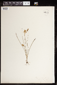 960299[1318788]Marsh, Ellen F. 1886-05-29 United States, Illinois |
MIN:Plants | 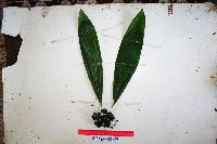 Molineria capitulata (Lour.) Herb. 923005[]Ctvrtecka, R. 42372009-02-24 Papua New Guinea, Madang, Baitabag Village, -5.13333 145.767, 50m |
MIN:Plants | 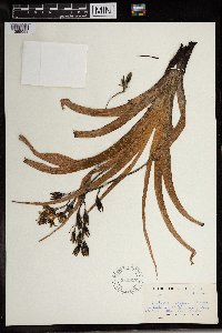 Hypoxis rooperii T. Moore 589817[1369058]Sidey, James L. 38671963-12-00 South Africa, Natal, Umkomaas Valley |
Google Map
Google Maps is a web mapping service provided by Google that features a map that users can pan (by dragging the mouse) and zoom (by using the mouse wheel). Collection points are displayed as colored markers that when clicked on, displays the full information for that collection. When multiple species are queried (separated by semi-colons), different colored markers denote each individual species.