University of Minnesota
http://www.umn.edu/
612-625-5000
http://www.umn.edu/
612-625-5000
Minnesota Biodiversity Atlas
Bell Museum
Dataset: MIN-Plants
Taxa: Primulaceae
Search Criteria: excluding cultivated/captive occurrences
Bell Museum plants | |
 MIN:Plants | Primula pumila (Ledebour) Pax 601141[]Munns, C. 5001966-06-29 United States, Alaska, Primrose Ridge in McKinley National Park;Denali National Park |
MIN:Plants | Primula pumila (Ledebour) Pax 699982[]Glaser, Paul 7931975-06-28 United States, Alaska, Mt. McKinley National Park...N1/2SW1/4Sec.18 T17S R14W, Thorofare Pass;Denali National Park;017S;14W;18, 1372m |
MIN:Plants | Primula pumila (Ledebour) Pax 355342[]West, Phebe 531932-07-03 United States, Alaska, Atka, Aleutian Islands;Aleutian Islands Wilderness;;;, 52.196111 -174.20056 |
MIN:Plants | Primula pumila (Ledebour) Pax 700060[]Glaser, Paul 7981975-06-28 United States, Alaska, Mt. McKinley National Park...N1/2SW1/4Sec.18 T17S R14W, Thorofare Pass;Denali National Park;017S;14W;18, 1372m |
MIN:Plants | Primula pumila (Ledebour) Pax 700061[]Glaser, Paul 7991975-06-28 United States, Alaska, Mt. McKinley National Park...NE1/4SW1/4Sec.18 T17S R14W, Thorofare Pass;Denali National Park;017S;14W;18, 1433m |
MIN:Plants | Primula pumila (Ledebour) Pax 281551[]Mexia, Ynes 20241928-06-21 United States, Alaska, McKinley National Park ... Mt. Margaret.;Denali National Park;;;, 63.75 -149.35, 2000m |
MIN:Plants | Primula pumila (Ledebour) Pax 700004[]Glaser, Paul 8991975-08-02 United States, Alaska, Mt. McKinley National Park...NE1/4SW1/4Sec.18 T17S R14W, Thorofare Pass;Denali National Park;017S;14W;18, 1433m |
MIN:Plants | Douglasia alaskana (Coville & Standley ex Hult̩n) S. Kelso 700035[]Glaser, Paul 8551975-07-08 United States, Alaska, Mt. McKinley National Park...SW1/4SW1/4Sec.8 T17S R14W, near Thorofare Bench mark;Denali National Park;017S;14W;08, 1676m |
MIN:Plants | Dodecatheon hendersonii A. Gray 601038[]Munns, C. 4301966-03-25 United States, California, Tulare, Sequoia National Park;Sequoia National Park |
MIN:Plants | Dodecatheon hendersonii A. Gray 499106[]Went, F. s.n.1966-06-00 United States, California, W. foothills Sierra Nevada |
MIN:Plants | 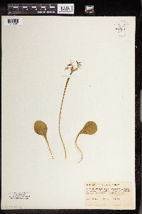 Dodecatheon hendersonii A. Gray 962398[1343597] United States, California |
MIN:Plants | 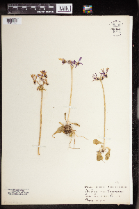 Dodecatheon hendersonii A. Gray 962399[1343598] United States, California |
MIN:Plants | Douglasia laevigata A. Gray 674744[]Abair, Christopher s.n.1976-08-04 United States, Washington, Clallam, Obstruction Pt, Olympic Natl Park;Olympic National Park |
MIN:Plants | Douglasia laevigata A. Gray 170174[]Elmer, A.D.E. 28011900-07-00 United States, Washington, Clallam, Olympic Mts. [Olympic National Park], 47.83 -123.83 |
MIN:Plants | Douglasia laevigata A. Gray 361302[]Rollins, Reed; et al. 26961938-08-09 United States, Washington, Clallam, Bogachiel ridge, headwaters of the Hoh River, Olympic Mountains, Clallam Co.;Olympic National Park, 1524m |
MIN:Plants | Douglasia laevigata A. Gray 584692[]Morean, Edith 2601962-08-07 United States, Washington, Clallam, Olympic National Park; Obstruction Point, towards Hurricane Ridge;Olympic National Park |
MIN:Plants | Douglasia laevigata A. Gray 290889[]Thompson, J. 56091930-08-02 United States, Washington, Clallam, Mt. Angeles...Olympic Mts. Clallam Co.;Olympic National Park, 1676m |
MIN:Plants | Douglasia laevigata A. Gray 638015[]Hoffman, Angela s.n.1973-08-21 United States, Washington, Olympic Natl Park;Olympic National Park |
MIN:Plants | Douglasia laevigata A. Gray 516540[]Piper, C. 10621890-09-30 United States, Washington, Clallam, Olympic Mts.;Olympic National Park |
MIN:Plants | Douglasia laevigata A. Gray 584661[]Morean, Edith 2591962-08-09 United States, Washington, Clallam, Olympic National Park; High Divide at Mt. Bogachiel;Olympic National Park |
MIN:Plants | Douglasia laevigata A. Gray 582016[]Morean, Edith 1561962-08-09 United States, Washington, Clallam, Olympic National Park, below Heart Lake;Olympic National Park |
MIN:Plants | Douglasia laevigata A. Gray 170177[]Piper, C. s.n.1895-08-00 United States, Washington, Clallam, Olympic Mts.;Olympic National Park, 1829m |
MIN:Plants | Primula egaliksensis Wormskj̦ld 413534[]Spetzman, L. 17931949-07-08 United States, Alaska, Arctic North Slope ... Anaktuvuk Pass;Gates of the Arctic National Park;;;, 68.2833333 -151.4166667, 610m |
MIN:Plants | Dodecatheon amethystinum (Fassett0 Fassett 593405[]Hartley, Thomas 70401959-07-01 United States, Iowa, Allamakee, Driftless Area...Waterloo Creek. Allamakee County...T100N; R6W; Sect. 35 Waterloo Twp;;100N;06W;35 |
MIN:Plants | Dodecatheon amethystinum (Fassett0 Fassett 763705[]Pierce, Jennie s.n.1902-05-00 United States, Minnesota, Winona, Fremont, Fillmore Co. [this village actually in Winona Co.];;105N;09W;00, 44.049963 -91.639315 |
MIN:Plants | Dodecatheon amethystinum (Fassett0 Fassett 403312[]Wadmond, S. s.n.1944-06-16 United States, Wisconsin, La Crosse, La Crosse County...from vic. of West Salem |
MIN:Plants | Dodecatheon amethystinum (Fassett0 Fassett 593571[]Hartley, Thomas; et al. 91331960-05-13 United States, Wisconsin, Trempealeau, Driftless Area...Mississippi River bluff. Perrot State Park. Trempealeau County, T18N; R9W; Trempealeau Twp.;;018N;09W;00 |
MIN:Plants | Dodecatheon amethystinum (Fassett0 Fassett 170153[]Holzinger, John s.n.1886-05-00 United States, Minnesota, Winona, [no further data];;;;, 44.0479 -91.6404 |
MIN:Plants | Dodecatheon amethystinum (Fassett0 Fassett 170154[]Wheeler, William 3401899-07-14 United States, Minnesota, Houston, Crooked Creek, Houston Co.;Dorer Memorial Hardwood State Forest;;;, 43.592621 -91.284352 |
MIN:Plants | Dodecatheon amethystinum (Fassett0 Fassett 178503[]Butters, F.; et al. 39131920-06-26 United States, Minnesota, Fillmore, Above Winch's Spring Valley of the South Fork, east of Amherst. Fillmore County;Dorer Memorial Hardwood State Forest;102N;09W;, 43.686908 -92.389059 |
MIN:Plants | Dodecatheon amethystinum (Fassett0 Fassett 178504[]Rosendahl, C. 47881925-05-03 United States, Minnesota, Winona, Base of Gwinn's Bluff.;Great River Bluffs State Park;106N;05W;, 43.953016 -91.393156 |
MIN:Plants | Dodecatheon amethystinum (Fassett0 Fassett 178507[]Holzinger, John s.n.1901-05-00 United States, Minnesota, Winona, [no further data];;;;, 44.0479 -91.6404 |
MIN:Plants | Dodecatheon amethystinum (Fassett0 Fassett 459742[]Leoschke, M.; et al. 8471989-05-20 United States, Iowa, Winneshiek, Winneshiek County: Highland Township T100N R7W Section 25 NW4SE4SW4 and S2SE4NE4SW4. North Bear Wildlife Management Area...is located about 2.5 miles east-northeast of Highlandville...southeast of North Bear Creek...The bluff is on the Paleozoic Plateau (Driftless Area).. 100N 07W 25 |
MIN:Plants | Dodecatheon amethystinum (Fassett0 Fassett 178508[]Holzinger, John s.n.1886-05-08 United States, Minnesota, Winona, [no further data];;;;, 44.0479 -91.6404 |
MIN:Plants | Dodecatheon amethystinum (Fassett0 Fassett 178509[]Manning, Sara s.n.1888-05-24 United States, Minnesota, Winona, Minnesota City.;;108N;07W;, 44.093852 -91.749596 |
MIN:Plants | Dodecatheon amethystinum (Fassett0 Fassett 178510[]White, Sidney s.n.1889-05-04 United States, Minnesota, Winona, Bear Creek [no county specified but Winona County had a pioneer village/rail stop by this name in T107N R09W Sec 15]. 107N 09W 15, 44.069785 -91.88447 |
MIN:Plants | Dodecatheon amethystinum (Fassett0 Fassett 178514[]Butters, F.; et al. 42661922-05-31 United States, Minnesota, Winona, Near Richmond. Winona County;;;;, 44.049963 -91.639315 |
MIN:Plants | Dodecatheon amethystinum (Fassett0 Fassett 178515[]Butters, F.; et al. 42661922-05-31 United States, Minnesota, Winona, Near Richmond.;;;;, 44.049963 -91.639315 |
MIN:Plants | Dodecatheon amethystinum (Fassett0 Fassett 227894[]Rosendahl, C. 49261926-05-16 United States, Minnesota, Winona, at the base of Gwinns Bluff. Winona Co.;Great River Bluffs State Park;106N;05W;, 43.946353 -91.399309 |
MIN:Plants | Dodecatheon amethystinum (Fassett0 Fassett 227895[]Rosendahl, C. 5375b1927-08-13 United States, Minnesota, Houston, About 3 mmiles west of Houston, Sect. 35, Money Creek Twp. Houston County;Dorer Memorial Hardwood State Forest;104N;07W;35, 43.768135 -91.641109 |
MIN:Plants | Dodecatheon amethystinum (Fassett0 Fassett 264341[]White, Sidney s.n.1891-06-00 United States, Minnesota, Winona, [no data but other collections from Winona area];;;;, 44.0333 -91.6333 |
MIN:Plants | Dodecatheon amethystinum (Fassett0 Fassett 333641[]Holzinger, John s.n.1901-06-00 United States, Minnesota, Winona, At the foot of Gwinn's Bluff. Winona County;Great River Bluffs State Park;106N;05W;, 43.946353 -91.399309 |
MIN:Plants | Dodecatheon amethystinum (Fassett0 Fassett 350598[]Lewis, Allison s.n.1937-05-15 United States, Minnesota, Winona, Gwinn's Bluff.;Great River Bluffs State Park;106N;05W;, 43.955293 -91.410815 |
MIN:Plants | Dodecatheon amethystinum (Fassett0 Fassett 350599[]Larson, Edith s.n.1937-05-16 United States, Minnesota, Winona, Gwinn's Bluff.;Great River Bluffs State Park;106N;05W;, 43.955293 -91.410815 |
MIN:Plants | Dodecatheon amethystinum (Fassett0 Fassett 350965[]Rosendahl, C.; et al. 18511933-05-14 United States, Minnesota, Wabasha, About 7 miles below Lake City.;Dorer Memorial Hardwood State Forest;;;, 44.348033 -92.266844 |
MIN:Plants | Dodecatheon amethystinum (Fassett0 Fassett 364097[]McIntire, Jessie s.n.1920-00-00 United States, Minnesota, Fillmore, Amherst.;Dorer Memorial Hardwood State Forest;102N;09W;, 43.608577 -91.894877 |
MIN:Plants | Dodecatheon amethystinum (Fassett0 Fassett 366445[]Rosendahl, C.; et al. 72201939-06-23 United States, Minnesota, Winona, Dorer Memorial Hardwood State Forest. Just opposite the S end of Trumpealeau Mountain; along Hwy. 61, 3/4 mi. below Indian Inscription Caves (caves are ca. 3 mi. below Lamoille).. 106N 05W , 43.956549 -91.4667 |
MIN:Plants | Dodecatheon amethystinum (Fassett0 Fassett 405954[]Rosendahl, C. 77921947-07-06 United States, Minnesota, Houston, Along the road down to Yucatan Valley, Sec. 8, Blackhammer Twp.;Dorer Memorial Hardwood State Forest;102N;07W;08, 43.6519 -91.700334 |
MIN:Plants | Dodecatheon amethystinum (Fassett0 Fassett 412633[]Moore, John 106881939-05-14 United States, Minnesota, Winona, Winona County...along the north side of Gwinn's Bluff, 4 miles below Lamoille.;Great River Bluffs State Park;106N;05W;, 43.942065 -91.4667 |
MIN:Plants | Dodecatheon amethystinum (Fassett0 Fassett 572836[]Moore, John 254131961-06-08 United States, Minnesota, Houston, Houston County...Riceford Creek, Blackhammer Twp, S of Yucatan.;Dorer Memorial Hardwood State Forest;102N;07;, 43.631344 -91.673392 |
MIN:Plants | Dodecatheon amethystinum (Fassett0 Fassett 604030[]Moore, John; et al. 271841967-06-16 United States, Minnesota, Houston, Houston County...2 1/2 mi. SE of Hokah.;Dorer Memorial Hardwood State Forest;;;, 43.733801 -91.311075 |
MIN:Plants | Dodecatheon amethystinum (Fassett0 Fassett 700563[]Ownbey, Gerald 61291978-08-14 United States, Minnesota, Houston, Houston County...T104N, R5W, W1/2 Sec. 34. Rte. 16, 3.7 mi. W of the cemetery, W side of Hokah.;Dorer Memorial Hardwood State Forest;104N;05W;34, 43.767743 -91.42281 |
MIN:Plants | Dodecatheon amethystinum (Fassett0 Fassett 711405[]Smith, Welby 9811979-06-13 United States, Minnesota, Houston, Houston County...T102N, R07W; NE1/4 NW1/4 Sec. 8. On the W side of Hwy. 4.;Dorer Memorial Hardwood State Forest;102N;07W;08, 43.656848 -91.703083 |
MIN:Plants | Dodecatheon amethystinum (Fassett0 Fassett 711407[]Smith, Welby 9831979-06-13 United States, Minnesota, Houston, Houston County...T103N, R7W, SE1/4 Sec. 36. On the NW side of Hwy. 11.;Dorer Memorial Hardwood State Forest;103N;07W;36, 43.677737 -91.616711 |
MIN:Plants | Dodecatheon amethystinum (Fassett0 Fassett 711414[]Smith, Welby 9901979-06-13 United States, Minnesota, Winona, Winona County...T106N, R5W, NE1/4 NE1/4 Sec. 27. O.L. Kipp State Park. At the W side of Queen's Bluff.;Great River Bluffs State Park;106N;05W;27, 43.955293 -91.410815 |
MIN:Plants | Dodecatheon amethystinum (Fassett0 Fassett 723718[]Woolsey, Henry; et al. s.n.1980-06-18 United States, Minnesota, Winona, Winona County...Near the center of S1/2 SW1/4 of Sec. 22, T106N, R5W. Near the base of King's Bluff.;Great River Bluffs State Park;106N;05W;22, 43.968547 -91.415042 |
MIN:Plants | Dodecatheon amethystinum (Fassett0 Fassett 724596[]Smith, Welby 22691980-05-28 United States, Minnesota, Houston, Dorer Memorial Hardwood State Forest. Houston County...T103N, R6W, SW1/4 SE1/4 SW1/4 Sec. 27...about 150 ft. S of Hwy. 76, between Badger Creek and the top of a N-facing bluff.. 103N 06W 27, 43.695682 -91.541201 |
MIN:Plants | Dodecatheon amethystinum (Fassett0 Fassett 745061[]Smith, Welby 37841981-05-14 United States, Minnesota, Olmsted, Olmsted County...About 1/2 mi W of King's Park, on the S-side of the Middle Fork Zumbro River...SE1/4 SE1/4 Sec. 15, T108N, R14W.. 108N 14W 15, 44.1538 -92.481112 |
MIN:Plants | Dodecatheon amethystinum (Fassett0 Fassett 745354[]Smith, Welby 38191981-05-18 United States, Minnesota, Houston, Houston County...On the S-side of Hwy. 16, about 2 1/4 mi. W of Hokah...SW1/4 NE1/4 Sec. 2, T103N, R5W.;Dorer Memorial Hardwood State Forest;103N;05W;02, 43.75489 -91.400451 |
MIN:Plants | Dodecatheon amethystinum (Fassett0 Fassett 750591[]Peterson, Jon 431982-05-03 United States, Minnesota, Houston, Houston Co. Gap Hill #1; ca. 4 mi. W of Hokah on the N side of Hwy. 16. NW1/4 SW1/4 Sec. 34, T104N, R5W.;Dorer Memorial Hardwood State Forest;104N;05W;34, 43.767566 -91.402884 |
MIN:Plants | Dodecatheon amethystinum (Fassett0 Fassett 795577[]Gunderson, Harvey s.n.1940-05-19 United States, Minnesota, Winona, Near Gwinn's Bluff.;Great River Bluffs State Park;106N;05W;, 43.946353 -91.399309 |
MIN:Plants | 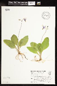 Dodecatheon amethystinum (Fassett0 Fassett 812593[1158296]Ostlie, Wayne 1061990-05-09 United States, Minnesota, Houston, Crystal Creek Algific Slope, Crystal Creek Valley. SW1/4 SE1/4 Sheldon Twp.;Dorer Memorial Hardwood State Forest;103N;06W;24, 43.705127 -91.498496 |
MIN:Plants | Dodecatheon amethystinum (Fassett0 Fassett 829641[]Zager, S. 930715-31993-07-15 United States, Minnesota, Houston, Houston Co. Oak Ridge Unit State Forest; MCBS #19. SE1/4 NW1/4 NW1/4 Sec.14 T103N R07W;Dorer Memorial Hardwood State Forest;103N;07W;14, 43.729402 -91.633546 |
MIN:Plants | Dodecatheon amethystinum (Fassett0 Fassett 829710[]Nation, R. 10091993-05-18 United States, Minnesota, Winona, Winona County...About 2 mi W and 1 1/2 mi N from Whitman; T108N R09W SW1/4 of NE1/4 of Sec.12;;108N;09W;12, 44.171782 -91.849011 |
MIN:Plants | Dodecatheon amethystinum (Fassett0 Fassett 829712[]Nation, R. 10031993-05-05 United States, Minnesota, Wabasha, Dorer Memorial Hardwood State Forest. Wabasha County...About 1 mi S of Zumbro Falls, along the N fork of the Zumbro River...T109N R13W SE1/4 of SW1/4 of Sec.6. 109N 13W 6, 44.265895 -92.409344 |
MIN:Plants | Dodecatheon amethystinum (Fassett0 Fassett 829766[]Kern, Carole 21171993-07-22 United States, Minnesota, Houston, Houston Co. MCBS #22, T-103N R-7W Sec.30 SE4 NE4. Bluff Prairie;Dorer Memorial Hardwood State Forest;103N;07W;30, 43.696749 -91.712987 |
MIN:Plants | Dodecatheon amethystinum (Fassett0 Fassett 427320[]Dunevitz, H. 6411992-07-21 United States, Minnesota, Winona, Dorer Memorial Hardwood State Forest. Winona County...R.J. Dorer State Forest. About 1 1/2 miles southwest of Goodview; 'Hart Hill'...T 107N R 08W SW1/4 of NW1/4 of sec 24. 107N 08W 24, 44.0575 -91.7397222 |
MIN:Plants | Dodecatheon amethystinum (Fassett0 Fassett 433155[]Kern, Carole 20661993-06-26 United States, Minnesota, Houston, Houston Co.; MCBS # 1. T-104-N R-7-W Sec. 19 NW4 NW4.;Dorer Memorial Hardwood State Forest;104N;07W;19, 43.801408 -91.72775 |
MIN:Plants | Dodecatheon amethystinum (Fassett0 Fassett 436408[]Dunevitz, H. 5191991-08-14 United States, Minnesota, Winona, John Latch State Park. Winona County...John A. Latsch State Park; bluff above the Mississippi River, 1/2 mile northwest of Whitman...T 108N R 08W SW1/4 of NW1/4 of Sec 17. 108N 08W 17, 44.1602778 -91.8183333 |
MIN:Plants | Dodecatheon amethystinum (Fassett0 Fassett 440513[]Smith, Welby 149731988-08-24 United States, Minnesota, Fillmore, Fillmore County...In the Root River Valley, about 3 mi W-SW of Rushford...SE1/4 NW1/4 sec.28, T104N R8W;Rushford Sand Barrens Scientific Natural Area;104N;08W;28, 43.697356 -92.0417 |
MIN:Plants | Dodecatheon amethystinum (Fassett0 Fassett 440878[]Lee, Michael MDL10261995-06-16 United States, Minnesota, Wabasha, Wabasha County...slope along the Zumbro River 1 mi N of Hammond...T109N R13W SWNE 21;Dorer Memorial Hardwood State Forest;109N;13W;21, 44.212766 -92.479382 |
MIN:Plants | Dodecatheon amethystinum (Fassett0 Fassett 444099[]Lee, Michael MDL5141994-06-06 United States, Minnesota, Fillmore, Fillmore County...Magelssen Bluff, overlooking the city of Rushford...T 104N R 8W SW1/4 of NE1/4 of Sec 14;;104N;08W;14, 43.812187 -91.757557 |
MIN:Plants | Dodecatheon amethystinum (Fassett0 Fassett 453106[]Zager, S. 940608-61994-06-08 United States, Minnesota, Fillmore, Fillmore County...T103N R08W SW1/4, NE1/4, NW1/4, NE1/4, 13;Dorer Memorial Hardwood State Forest;103N;08W;13, 43.730111 -91.734161 |
MIN:Plants | Dodecatheon amethystinum (Fassett0 Fassett 455803[]Kern, Carole 2026A1993-05-27 United States, Minnesota, Houston, Beaver Creek Valley State Park. Houston Co.; MCBS #60; T-102-N R-06-W Sec. 08 SW4 SE4 NW4. Take Plateau Rock Trail to the point of the hill; at small dolomite outcrop before the end of the trail and before the overlook; Beaver [etc.]. 102N 06W 8, 43.652158 -91.580811 |
MIN:Plants | Dodecatheon amethystinum (Fassett0 Fassett 455932[]Kern, Carole 20311993-06-05 United States, Minnesota, Houston, Dorer Memorial Hardwood State Forest. Houston Co.; MCBS #3; T-104-N R-07-W Sec. 27 NE4 SE4 NE4. One half mile east of teh junction of T-270 and T-272, south side of the road.. 104N 07W 27, 43.782511 -91.65282 |
MIN:Plants | Dodecatheon amethystinum (Fassett0 Fassett 455934[]Kern, Carole 20361993-06-11 United States, Minnesota, Houston, Houston Co.; T-104-N R-07-W Sec. 11 SW4 NE4 SE4. Along Hwy 26 (roadside).;Dorer Memorial Hardwood State Forest;104N;07W;11, 43.822529 -91.633565 |
MIN:Plants | Dodecatheon amethystinum (Fassett0 Fassett 455935[]Kern, Carole 20381993-06-11 United States, Minnesota, Houston, Houston Co.; T-104-N R-07-W Sec.17 SE4 NW4 SE4. Along Hwy 26 (roadside).;Dorer Memorial Hardwood State Forest;104N;07W;17, 43.808408 -91.697709 |
MIN:Plants | Dodecatheon amethystinum (Fassett0 Fassett 458683[]Lee, Michael MDL5011994-05-31 United States, Minnesota, Fillmore, Fillmore County...Lobland Valley...T103N R9W SW1/4 of NW1/4 of sec 4;Dorer Memorial Hardwood State Forest;103N;09W;04, 43.754731 -91.927411 |
MIN:Plants | Dodecatheon amethystinum (Fassett0 Fassett 459033[]Lee, Michael MDL4651994-05-21 United States, Minnesota, Fillmore, Fillmore County...1 3/4 miles NNW of Bratsberg; T103N R8W NW1/4 of NW1/4 of Sec 3;Dorer Memorial Hardwood State Forest;103N;08W;03, 43.758199 -91.787343 |
MIN:Plants | Dodecatheon amethystinum (Fassett0 Fassett 459060[]Lee, Michael MDL4301994-05-15 United States, Minnesota, Fillmore, Dorer Memorial Hardwood State Forest. Fillmore County...along upper reaches of Diamond Creek 2 1/2 miles NE of Highland...T103N R08W SE1/4 of NW1/4 of Sec 19. 103N 08W 19, 43.711413 -91.843021 |
MIN:Plants | Dodecatheon amethystinum (Fassett0 Fassett 459062[]Lee, Michael MDL4121994-05-10 United States, Minnesota, Fillmore, Fillmore County...4 miles N of Highland...T103N R09W NE1/4 of SE1/4 of Sec 11;Dorer Memorial Hardwood State Forest;103N;09W;11, 43.736836 -91.872537 |
MIN:Plants | Dodecatheon amethystinum (Fassett0 Fassett 459064[]Lee, Michael MDL4171994-05-11 United States, Minnesota, Fillmore, Fillmore County...upper reaches of Diamond Creek valley 2.5 miles NNE of Highland...T103N R08W NW1/4 of NW1/4 of Sec 19;Dorer Memorial Hardwood State Forest;103N;08W;19, 43.715322 -91.847655 |
MIN:Plants | Dodecatheon amethystinum (Fassett0 Fassett 459065[]Lee, Michael MDL4181994-05-11 United States, Minnesota, Fillmore, Fillmore County...3.5 miles N of Highland...T103N R09W NE1/4 of NW1/4 of Sec 13;Dorer Memorial Hardwood State Forest;103N;09W;13, 43.729545 -91.86265 |
MIN:Plants | Dodecatheon amethystinum (Fassett0 Fassett 459068[]Lee, Michael MDL4101994-05-10 United States, Minnesota, Fillmore, Fillmore County...1.5 miles SE of Whalan...T103N R09W SW1/4 of SW1/4 of Sec 15;Dorer Memorial Hardwood State Forest;103N;09W;15, 43.719095 -91.90748 |
MIN:Plants | Dodecatheon amethystinum (Fassett0 Fassett 459069[]Lee, Michael MDL4041994-05-04 United States, Minnesota, Fillmore, Fillmore County...Shattuck Creek valley...T102N R8W SW1/4 of NW1/4 of Sec.8;Dorer Memorial Hardwood State Forest;102N;08W;08, 43.653931 -91.827295 |
MIN:Plants | Dodecatheon amethystinum (Fassett0 Fassett 459070[]Lee, Michael MDL4021994-05-04 United States, Minnesota, Fillmore, Fillmore County...Shattuck Creek valley, 2.25 miles SE of Highland...T102N R08W SE1/4 of NW1/4 of Sec 7;Dorer Memorial Hardwood State Forest;102N;08W;07, 43.653765 -91.842206 |
MIN:Plants | Dodecatheon amethystinum (Fassett0 Fassett 459071[]Lee, Michael MDL4011994-05-04 United States, Minnesota, Fillmore, Fillmore County...along Shattuck Creek 3 miles WSW of Choice...T102N R8W SW1/4 of NW1/4 of sec 7;Dorer Memorial Hardwood State Forest;102N;08W;07, 43.65389 -91.847613 |
MIN:Plants | Dodecatheon amethystinum (Fassett0 Fassett 459075[]Lee, Michael MDL4191994-05-12 United States, Minnesota, Fillmore, Fillmore County...ridge along Wisel Creek 2.5 miles W of Tawney...T102N R08W SW1/4 of SE1/4 of sec 19;Dorer Memorial Hardwood State Forest;102N;08W;19, 43.618158 -91.837967 |
MIN:Plants | Dodecatheon amethystinum (Fassett0 Fassett 459076[]Lee, Michael MDL4051994-05-06 United States, Minnesota, Fillmore, Fillmore County...Shattuck Creek valley, "cabbage rocks", 2.5 miles SE of Highland...T102N R8W NE1/4 of NW1/4 of sec 8;Dorer Memorial Hardwood State Forest;102N;08W;08, 43.657035 -91.821372 |
MIN:Plants | Dodecatheon amethystinum (Fassett0 Fassett 459081[]Lee, Michael MDL5101994-06-01 United States, Minnesota, Fillmore, Fillmore County...T104N R8W SW1/4 of SE1/4 of Sec 36;;104N;08W;36, 43.76218 -91.738048 |
MIN:Plants | Dodecatheon amethystinum (Fassett0 Fassett 459248[]Lee, Michael MDL4911994-05-27 United States, Minnesota, Fillmore, Fillmore County...upper reaches of Big Springs Creek valley 1 mile SSW of Arendahl...T104N R9W SW1/4 of NE1/4 of sec 16;Dorer Memorial Hardwood State Forest;104N;09W;16, 43.812527 -91.917335 |
MIN:Plants | Dodecatheon amethystinum (Fassett0 Fassett 464653[]Dunevitz, H. 8511993-06-15 United States, Minnesota, Wabasha, Wabasha County...About one mile south of Zumbro Falls...west side of the Zumbro River...T 109 R 13 NW1/4 of N;Zumbro Falls Woods Scientific Natural Area;T109N R13W S08, 44.212766 -92.479382 |
MIN:Plants | Dodecatheon amethystinum (Fassett0 Fassett 475086[]Kern, Carole 21351993-08-16 United States, Minnesota, Houston, Houston Co.; MCBS #19. T-103-N R-7-W SEC.14 NW4 SW4;Dorer Memorial Hardwood State Forest;103N;07W;14, 43.727213 -91.645209 |
MIN:Plants | Dodecatheon amethystinum (Fassett0 Fassett 475523[]Dunevitz, H. 9181993-07-21 United States, Minnesota, Winona, Dorer Memorial Hardwood State Forest. Winona County...Two miles north and south of Minnesota City on bluff above Mississippii River; T 108 R 8 NE1/4 of SE1/4 of Sec 28. T108N R08W S28, 44.12818 -91.789602 |
MIN:Plants | Dodecatheon amethystinum (Fassett0 Fassett 475530[]Dunevitz, H. 10361994-05-04 United States, Minnesota, Wabasha, Dorer Memorial Hardwood State Forest. Wabasha County...One mile north & 1 1/2 miles east of Hammond, 1/4 mile north of the Zumbro River T 109N R 13W SE1/4 of SW1/4 of Sec 14. 109N 13W 14, 44.2388889 -92.3416667 |
MIN:Plants | Dodecatheon amethystinum (Fassett0 Fassett 475537[]Dunevitz, H. 10351994-05-04 United States, Minnesota, Wabasha, Dorer Memorial Hardwood State Forest. Wabasha County...1/2 mile east of the town of Jarrett, on a northwest-facing slope above the Zumbro River... T 109N R 13W NE1/4 of NW1/4 of sec 24. 109N 13W 24, 44.2347222 -92.325 |
MIN:Plants | Dodecatheon amethystinum (Fassett0 Fassett 476294[]Dunevitz, H. 6581992-05-19 United States, Minnesota, Winona, Great River Bluffs State Park. Winona County...in O.L. Kipp State Park, 1/4 mile north of interstate 90, 1 1/2 miles west of highway 61...T 105N R 05W SE1/4 of NW1/4 of Sec 2. 105N 05W 2, 43.9286111 -91.3925 |
MIN:Plants | Dodecatheon amethystinum (Fassett0 Fassett 476390[]Dunevitz, H. 6831992-06-04 United States, Minnesota, Winona, Upper Mississippi National Wildlife Refuge. Winona County...1-1/2 miles northwest of Minnesota City...bluff above highway 61 & the Mississippi River... 108N R 08W SW1/4 of NE1/4 of sec 34. 108N 08W 34, 44.1158333 -91.7661111 |
MIN:Plants | Dodecatheon amethystinum (Fassett0 Fassett 476392[]Dunevitz, H. 5781991-06-24 United States, Minnesota, Winona, Dorer Memorial Hardwood State Forest. Winona County...about 3 miles south and east of La Moille, on bluff above the Mississippi River; T 106N R 05W NE1/4 of NW1/4 of Sec 21. 106N 05W 21, 43.969755 -91.430648 |
MIN:Plants | Dodecatheon amethystinum (Fassett0 Fassett 478442[]Kern, Carole 21021993-07-19 United States, Minnesota, Houston, Houston Co.; MCBS # 87. T-103-N R-04-W Sec. 6 NW4 NW4. Hokah Ridge Prairie.;Dorer Memorial Hardwood State Forest;103N;04W;06, 43.758606 -91.370473 |
Google Map
Google Maps is a web mapping service provided by Google that features a map that users can pan (by dragging the mouse) and zoom (by using the mouse wheel). Collection points are displayed as colored markers that when clicked on, displays the full information for that collection. When multiple species are queried (separated by semi-colons), different colored markers denote each individual species.