University of Minnesota
http://www.umn.edu/
612-625-5000
http://www.umn.edu/
612-625-5000
Minnesota Biodiversity Atlas
Bell Museum
Dataset: MIN-Plants
Taxa: Brassicaceae
Search Criteria: excluding cultivated/captive occurrences
Bell Museum plants | |
 MIN:Plants | Capsella bursa-pastoris (L.) Medikus 118056[]Oestlund, O. s.n.1886-06-04 United States, Minnesota, Hennepin, [no further data];;;;, 45 -93.47 |
MIN:Plants | Capsella bursa-pastoris (L.) Medikus 118057[]MacMillan, C.; et al. 4201900-08-00 United States, Minnesota, Polk, Crookston;;150N;46W;30, 47.782 -96.60007 |
MIN:Plants | Capsella bursa-pastoris (L.) Medikus 118058[]Kassube, J. s.n.1878-05-00 United States, Minnesota, Hennepin, Minneapolis;;N;;, 44.979965 -93.263836 |
MIN:Plants | Capsella bursa-pastoris (L.) Medikus 118059[]Sheldon, Edmund s.n.1895-05-00 United States, Minnesota, Hennepin, Minneapolis;;N;;, 44.979965 -93.263836 |
MIN:Plants | Capsella bursa-pastoris (L.) Medikus 118060[]Sheldon, Edmund S24531892-06-00 United States, Minnesota, Mille Lacs, Mille Lacs Lake.;;N;;, 46.242562 -93.646251 |
MIN:Plants | Capsella bursa-pastoris (L.) Medikus 118061[]Sheldon, Edmund S4871891-06-00 United States, Minnesota, Blue Earth, Duck Lake;;N;;, 44.218031 -93.815742 |
MIN:Plants | Capsella bursa-pastoris (L.) Medikus 118062[]Frost, W. F111892-06-00 United States, Minnesota, Meeker, Litchfield;;119N;31W;, 45.12722 -94.52778 |
MIN:Plants | Capsella bursa-pastoris (L.) Medikus 118063[]Herrick, C. s.n.1877-05-24 United States, Minnesota, Hennepin, Minneapolis;;N;;, 44.979965 -93.263836 |
MIN:Plants | Capsella bursa-pastoris (L.) Medikus 118064[]McElligott, T. s.n.1890-06-01 United States, Minnesota, McLeod, Glencoe;;N;;, 44.769129 -94.151642 |
MIN:Plants | Capsella bursa-pastoris (L.) Medikus 118065[]Hammond, George 81881-05-00 United States, Minnesota, Wabasha, Lake City;;N;;, 44.44402 -92.273367 |
MIN:Plants | Capsella bursa-pastoris (L.) Medikus 118066[]Aiton, G. s.n.1890-07-00 United States, Minnesota, Hennepin, [no further data];;;;, 45 -93.47 |
MIN:Plants | Capsella bursa-pastoris (L.) Medikus 263918[]Holzinger, John s.n.1901-05-00 United States, Minnesota, Winona, Winona Co.;;N;;, 43.926613 -91.67387 |
MIN:Plants | Capsella bursa-pastoris (L.) Medikus 265438[]Anonymous G511912-00-00 United States, Minnesota, Rice, Northfield;;N;;, 44.458298 -93.161604 |
MIN:Plants | Capsella bursa-pastoris (L.) Medikus 270047[]Wheeler, William 801893-06-00 United States, Minnesota, Houston, Houston Co.;;N;;, 43.641186 -91.496866 |
MIN:Plants | Capsella bursa-pastoris (L.) Medikus 276113[]Moyle, J. 501930-06-24 United States, Minnesota, Clearwater, Itasca Park, Campus; SE1/4 SE1/4 Sec. 2 T143N R36W;Itasca State Park;143N;36W;2, 47.231973 -95.201528 |
MIN:Plants | Capsella bursa-pastoris (L.) Medikus 277784[]Roberts, Thomas s.n.1877-06-00 United States, Minnesota, Hennepin, Minneapolis;;N;;, 44.979965 -93.263836 |
MIN:Plants | Capsella bursa-pastoris (L.) Medikus 288357[]Piruerisal, F. s.n.1914-05-30 United States, Minnesota, [no further data];;;;, 46 -94 |
MIN:Plants | Capsella bursa-pastoris (L.) Medikus 288615[]Meck, Carlton s.n.1914-05-17 United States, Minnesota, Ramsey, St. Anthony Park [St Paul neighborhood near U of M];;029N;23W;, 44.992077 -93.166387 |
MIN:Plants | Capsella bursa-pastoris (L.) Medikus 301986[]Himebaugh, W. s.n.1928-05-00 United States, Minnesota, Hennepin, Campus, University of Minnesota;;N;;, 44.97441 -93.233002 |
MIN:Plants | Capsella bursa-pastoris (L.) Medikus 306019[]Siemers, Ross 491977-06-09 United States, Minnesota, Morrison, MacDougall Homestead Preserve, near buildings.;MacDougall Homestead, The Nature Conservancy;039N;32W;, 45.868856 -94.31068 |
MIN:Plants | Capsella bursa-pastoris (L.) Medikus 336420[]Lakela, Olga 1502b1936-07-09 United States, Minnesota, Saint Louis, Along trail in sand dune at the bus terminal, Duluth.;;N;;, 46.783273 -92.106579 |
MIN:Plants | Capsella bursa-pastoris (L.) Medikus 336421[]Lakela, Olga 15551936-07-21 United States, Minnesota, Saint Louis, Back of a garage near Duluth ship canal, bayside, Duluth.;;N;;, 46.7684 -92.09787 |
MIN:Plants | Capsella bursa-pastoris (L.) Medikus 349994[]Rosendahl, C.; et al. 30351935-05-19 United States, Minnesota, Pipestone, Near Pipestone. Pipestone Co.;;106N;46W;, 43.979723 -96.367859 |
MIN:Plants | Capsella bursa-pastoris (L.) Medikus 352423[]Rosendahl, C.; et al. 30251935-05-19 United States, Minnesota, Pipestone, Pipestone;Pipestone National Monument;106N;46W;, 43.979723 -96.367859 |
MIN:Plants | Capsella bursa-pastoris (L.) Medikus 352681[]Benner, F.; Benner, J. 6711929-08-20 United States, Minnesota, Cook, 1 mi E Grand Portage;Grand Portage Indian Reservation / North Shore;063N;06E;, 47.958468 -89.703576 |
MIN:Plants | Capsella bursa-pastoris (L.) Medikus 356926[]Stevenson, J. 3481912-08-22 United States, Minnesota, Itasca, Grand Rapids;;N;;, 47.237166 -93.530214 |
MIN:Plants | Capsella bursa-pastoris (L.) Medikus 357045[]Anonymous 1131912-06-16 United States, Minnesota, Saint Louis, Meadowlands.;;N;;, 47.071884 -92.732416 |
MIN:Plants | Capsella bursa-pastoris (L.) Medikus 359317[]Alaspa, E.; Alaspa, H. s.n.1940-07-09 United States, Minnesota, Carlton, 2 mi. S of Cloquet.;;N;;, 46.692656 -92.459357 |
MIN:Plants | Capsella bursa-pastoris (L.) Medikus 363202[]Beach, W. 981913-05-22 United States, Minnesota, Ramsey, University Farm [University of MN, St. Paul];;029N;23W;, 44.992077 -93.166387 |
MIN:Plants | Capsella bursa-pastoris (L.) Medikus 368819[]Lakela, Olga 44821941-07-09 United States, Minnesota, Lake, Shore of Lake Superior at Knife River;;N;;, 46.948845 -91.782191 |
MIN:Plants | Capsella bursa-pastoris (L.) Medikus 369961[]Moore, John; et al. 140701941-05-24 United States, Minnesota, Chisago, Beside hwy 61; NE1/4 Sec. 4 Rushseba Twp.;;;;, 45.688333 -92.931944 |
MIN:Plants | Capsella bursa-pastoris (L.) Medikus 370007[]Moore, John; et al. 139391941-05-11 United States, Minnesota, Fillmore, Root River, 5.9 mi SW of Peterson, Fillmore Co.;Dorer Memorial Hardwood State Forest;;;, 43.731753 -91.92283 |
MIN:Plants | Capsella bursa-pastoris (L.) Medikus 383783[]Moore, John 157791943-06-19 United States, Minnesota, Dakota, Banks of the Vermillion River at Hastings;;N;;, 44.739075 -92.862655 |
MIN:Plants | Capsella bursa-pastoris (L.) Medikus 407596[]Lakela, Olga 82301949-06-07 United States, Minnesota, Saint Louis, 40th Ave. W Skyline Parkway, Duluth.;;N;;, 46.75817 -92.16362 |
MIN:Plants | Capsella bursa-pastoris (L.) Medikus 412074[]Moore, John; et al. 111521939-07-26 United States, Minnesota, Lake of the Woods, Along the W bank of Pine Creek, Angle Inlet.;Northwest Angle;168N;34W;, 49.344621 -95.028893 |
MIN:Plants | Capsella bursa-pastoris (L.) Medikus 412200[]Moore, John; et al. 107261939-05-28 United States, Minnesota, Clearwater, Near the Forestry School, E side of Lake Itasca, Itasca State Park.;Itasca State Park;143N;36W;, 47.19557 -95.233216 |
MIN:Plants | Capsella bursa-pastoris (L.) Medikus 416795[]Lakela, Olga 97881949-09-12 United States, Minnesota, Saint Louis, Hwy. 1, S of Ely.;Superior National Forest;N;;, 47.846357 -91.840308 |
MIN:Plants | Capsella bursa-pastoris (L.) Medikus 418887[]Ahlgren, Clifford 1211949-06-22 United States, Minnesota, Lake, Quetico-Superior Wilderness Research Center;Boundary Waters Canoe Area Wilderness / Superior National Forest;064N;10W;09, 48.031651 -91.618862 |
MIN:Plants | Capsella bursa-pastoris (L.) Medikus 424023[]Emanuel, J. 1111946-07-29 United States, Minnesota, Itasca, County: Itasca. Locality: Nashwauk Township. (Nashwauk);;057N;22W;, 47.414382 -93.132228 |
MIN:Plants | Capsella bursa-pastoris (L.) Medikus 429451[]Smith, Welby 208911992-07-15 United States, Minnesota, Marshall, Marshall County ... In Old Mill State Park, about 11 miles east of Argyle ... T 156N R 46W, NW1/4 of SE1/4 of sec 4;Old Mill State Park;156N;46W;4, 48.3602791 -96.5702744 |
MIN:Plants | Capsella bursa-pastoris (L.) Medikus 430712[]Smith, Welby 208231992-07-14 United States, Minnesota, Roseau, Roseau County ... T 159N R 39W NW1/4 of NE1/4 of Sec 1;;159N;39W;1, 48.6236115 -95.6111145 |
MIN:Plants | Capsella bursa-pastoris (L.) Medikus 437010[]Moore, John; Hall, Robert 163001944-06-08 United States, Minnesota, Nobles, Along Rock Island right of way, 1 mi N of Worthington;;N;;, 43.634449 -95.596398 |
MIN:Plants | Capsella bursa-pastoris (L.) Medikus 437036[]Moore, John; Hall, Robert 163261944-06-09 United States, Minnesota, Rock, Near Luverne;;N;;, 43.654136 -96.212807 |
MIN:Plants | Capsella bursa-pastoris (L.) Medikus 444734[]Moore, John; Goodwin, D. 193601946-10-19 United States, Minnesota, Crow Wing, E arm of Rabbit Lake N of Cuyuna;;N;;, 46.530365 -93.924032 |
MIN:Plants | Capsella bursa-pastoris (L.) Medikus 446459[]Moore, John; et al. 173981945-06-24 United States, Minnesota, Dakota, South St. Paul. Dakota Co.;;028N;22W;, 44.905226 -93.045075 |
MIN:Plants | Capsella bursa-pastoris (L.) Medikus 446675[]Moore, John; Huff, N. 177901945-07-23 United States, Minnesota, Morrison, Bank below the dam at Little Falls;;N;;, 45.976354 -94.362502 |
MIN:Plants | Capsella bursa-pastoris (L.) Medikus 448651[]Moore, John; Huff, N. 193201946-09-25 United States, Minnesota, Mille Lacs, On recreational area Father Hennepin State Memorial Wayside Park;Father Hennepin State Park;042N;25W;, 46.110955 -93.494831 |
MIN:Plants | Capsella bursa-pastoris (L.) Medikus 457929[]Manning, Sara s.n.1884-06-20 United States, Minnesota, Wabasha, Lake City;;N;;, 44.44402 -92.273367 |
MIN:Plants | Capsella bursa-pastoris (L.) Medikus 493032[]Lakela, Olga 172001953-11-22 United States, Minnesota, Saint Louis, Arboretum grounds at Fond du Lac, Duluth.;;N;;, 46.659664 -92.273248 |
MIN:Plants | Capsella bursa-pastoris (L.) Medikus 500025[]Rustad, Orwin 21946-06-10 United States, Minnesota, Rice, Along the roadside at Faribault;;N;;, 44.300084 -93.275981 |
MIN:Plants | Capsella bursa-pastoris (L.) Medikus 500793[]Moore, John 204691950-05-24 United States, Minnesota, Martin, Along the N shore of East Chain Lake;;N;;, 43.558844 -94.365248 |
MIN:Plants | 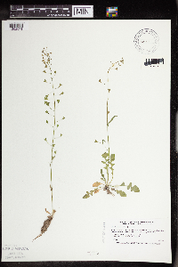 Capsella bursa-pastoris (L.) Medikus 504978[1352571]Smith, Welby 186141991-05-23 United States, Minnesota, Cass, Cass County ... about 5 mi NE of Pillager, in Pillsbury State Forest ... T134N R30W SW1/4 of NE1/;Pillsbury State Forest;134N;30W;26, 46.3916664 -94.421669 |
MIN:Plants | 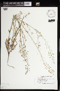 Capsella bursa-pastoris (L.) Medikus 508400[1352566]Smith, Welby 170471990-06-25 United States, Minnesota, Steele, Pogones Wildlife Management Area. Steele County ... Pogones State Wildlife Management Area, about 12 mi S-SE of Owatonna ... T105N R19W, NW1/4 of SE1/4 of Sec 18. 105N 19W 18, 43.8977776 -93.2783356 |
MIN:Plants | 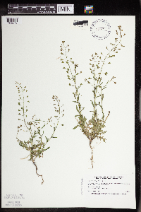 Capsella bursa-pastoris (L.) Medikus 508403[1352570]Smith, Welby 170021990-06-21 United States, Minnesota, Faribault, Fairbault [sic] Co. Pihls County Park, on the W side of Rice Lake, about 6 mi S of Wells; UTM: 337413E 157105N, T102N R2 Fairbault [sic] Co. Pihls County Park, on the W side of Rice Lake, about 6 mi S of Wells; UTM: 337413E 157105N, T102N R24W SW1/4 of NW1/4 of Sec 16 [W side of lake is in sec 17]. 102N 24W 17, 43.637329 -93.738191 |
MIN:Plants | Capsella bursa-pastoris (L.) Medikus 514270[]Smith, Welby 213111992-08-10 United States, Minnesota, Wadena, Wadena County ... at the public access on the NE end of Blueberry Lake, about 3 mi N-NE of Manahga ... T138N R35W NE1/4 of SW1/4 of sEc 2. 138N 35W 2, 46.7949982 -95.0699997 |
MIN:Plants | Capsella bursa-pastoris (L.) Medikus 514303[]Smith, Welby 189511991-06-25 United States, Minnesota, Todd, Grey Eagle Wildlife Management Area. Todd County ... Grey Eagle State Wildlife Management Area, about 3 miles W of Grey Eagle ... T127N R33W, SW1/4 of SE1/4 of Sec 10. 127N 33W 10, 45.8191681 -94.815834 |
MIN:Plants | Capsella bursa-pastoris (L.) Medikus 520014[]Smith, Welby 209911992-07-16 United States, Minnesota, Pennington, Pennington County ... on the W side of Co. Road 73, about 4.5 mi NW of the center of Thief River Falls T154N R44W NE1/4 of NE1/4 of Sec 13. 154N 44W 13, 48.163887 -96.2405548 |
MIN:Plants | Capsella bursa-pastoris (L.) Medikus 528958[]Borchard, Alma s.n.1945-06-13 United States, Minnesota, Blue Earth, Collected at Mapleton;;N;;, 43.928851 -93.956064 |
MIN:Plants | Capsella bursa-pastoris (L.) Medikus 532960[]Lakela, Olga 187191955-06-20 United States, Minnesota, Saint Louis, Former garden site at the Alworth building of University of Minnesota, Duluth;;N;;, 46.819076 -92.085253 |
MIN:Plants | Capsella bursa-pastoris (L.) Medikus 549768[]Moore, John; et al. 223141954-09-23 United States, Minnesota, Lincoln, Lincoln County...At tourist court grounds at SW end of Lake Benton;;109N;45W;08, 44.26273 -96.290997 |
MIN:Plants | Capsella bursa-pastoris (L.) Medikus 550037[]Moore, John 219231954-07-22 United States, Minnesota, Wilkin, Along the Otter Tail River 7 mi SE of Breckenridge;;N;;, 46.238119 -96.468467 |
MIN:Plants | Capsella bursa-pastoris (L.) Medikus 566578[]Moore, John 238671958-06-12 United States, Minnesota, Kittson, Along the banks of the river at Hallock.;;N;;, 48.774426 -96.946447 |
MIN:Plants | Capsella bursa-pastoris (L.) Medikus 566748[]Lang, H.; et al. 151878-05-09 United States, Minnesota, Ramsey, St. Paul;;;;, 44.948541 -93.095671 |
MIN:Plants | Capsella bursa-pastoris (L.) Medikus 592044[]Moore, John 267251965-05-24 United States, Minnesota, Isanti, NE1/4 Sec. 16, Athens Twp, Cedar Creek Natural History Area.;Cedar Creek National History Area;034N;23W;16, 45.435724 -93.214819 |
MIN:Plants | Capsella bursa-pastoris (L.) Medikus 592220[]Westkaemper, Remberta s.n.1964-06-00 United States, Minnesota, Stearns, Stearns Co. St. Joseph, St. Benedict College campus;;124N;29W;, 45.543642 -94.322053 |
MIN:Plants | Capsella bursa-pastoris (L.) Medikus 594141[]Thorne, Robert 310661962-07-16 United States, Minnesota, Clearwater, S of caretaker's buildings, campus, S side, Itasca State Park, NE1/4 Sec. 11, T143N, R36W.;Itasca State Park;143N;36W;11, 47.217521 -95.201495 |
MIN:Plants | Capsella bursa-pastoris (L.) Medikus 595433[]Vogel, A. 691965-05-16 United States, Minnesota, Brown, KC road, 3 mi N of New Ulm;;N;;, 44.355912 -94.460529 |
MIN:Plants | Capsella bursa-pastoris (L.) Medikus 603919[]Moore, John; et al. 271031967-06-08 United States, Minnesota, Pipestone, Pipestone County...W of the r.r. tracks, Pipestone National Monument.;Pipestone National Monument;106N;46W;01, 44.015848 -96.317669 |
MIN:Plants | Capsella bursa-pastoris (L.) Medikus 616738[]Moore, John; et al. 1781969-06-18 United States, Minnesota, Crow Wing, Crow Wing Natural History Area. Crow Wing County...Along the S line of the NW1/4 Sec. 20, Garrison Twp.;Crow Wing Natural Area;044N;28W;20, 46.279654 -93.90513 |
MIN:Plants | Capsella bursa-pastoris (L.) Medikus 618885[]Monserud, W. 1381949-05-23 United States, Minnesota, Hennepin, Backyard, 5255 Dupont Ave. N, Minneapolis.;;N;;, 44.9074 -93.29345 |
MIN:Plants | Capsella bursa-pastoris (L.) Medikus 631487[]Richards, Donald; et al. 15421954-06-03 United States, Minnesota, Itasca, Itasca County...Deer Lake, 18 mi NW of Grand Rapids, on N shore of lake;;;;, 47.37611 -93.66167 |
MIN:Plants | Capsella bursa-pastoris (L.) Medikus 655191[]Gage Jr., Addison 161876-05-23 United States, Minnesota, Hennepin, Minneapolis;;N;;, 44.979965 -93.263836 |
MIN:Plants | Capsella bursa-pastoris (L.) Medikus 681261[]Swanson, Steven 7951975-06-23 United States, Minnesota, Houston, Mississippi River (Navigation Pool #8). Houston Co. Site 26, N tip of Pettibone Island.;Upper Mississippi National Wildlife Refuge;N;;, 43.763684 -91.282376 |
MIN:Plants | Capsella bursa-pastoris (L.) Medikus 685201[]Stassen, Carol 771977-06-14 United States, Minnesota, Lyon, Camden State Park, beside park service road; T110N R42W Sec. 5;Camden State Park;110N;42W;5, 44.363323 -95.947736 |
MIN:Plants | Capsella bursa-pastoris (L.) Medikus 687110[]Wheeler, Gerald; Glaser, Paul 15361977-05-30 United States, Minnesota, Itasca, Site 35, SE1/4 SW1/4 Sec. 13, R26W; ca. 11 mi. SSW of Grand Rapids. Along the roadside shoulder of Hwy. 169.;;053N;26W;13, 47.078361 -93.581742 |
MIN:Plants | Capsella bursa-pastoris (L.) Medikus 687250[]Wheeler, Gerald; Glaser, Paul 16781977-06-20 United States, Minnesota, Itasca, Site 55. NE1/4 SE1/4 Sec. 20, T55N, R26W; ca. 5 mi. W of Grand Rapids.;;055N;26W;20, 47.232566 -93.670603 |
MIN:Plants | Capsella bursa-pastoris (L.) Medikus 689155[]Genenah, E. s.n.1967-05-14 United States, Minnesota, Kandiyohi, Green Lake;;N;;, 45.254131 -94.894452 |
MIN:Plants | Capsella bursa-pastoris (L.) Medikus 691146[]Sperling, C. 281976-04-25 United States, Minnesota, Douglas, 2.5 mi W, 3 mi S of Holmes City;;N;;, 45.790122 -95.593107 |
MIN:Plants | Capsella bursa-pastoris (L.) Medikus 717565[]Mathisen, Ron 371979-06-10 United States, Minnesota, Hubbard, Spearhead Lake Reserve.;Spearhead Lake Preserve (Audubon);145N;34W;, 47.368099 -94.990966 |
MIN:Plants | Capsella bursa-pastoris (L.) Medikus 728798[]Eikum, B. 861979-06-18 United States, Minnesota, Dakota, Hastings;Hastings Scientific Natural Area;115N;17W;, 44.73907 -92.86266 |
MIN:Plants | Capsella bursa-pastoris (L.) Medikus 729191[]Berlin, N. 751979-06-12 United States, Minnesota, Goodhue, Wacouta Pond Natural Area: 5 mi. SE of Red Wing. Portions of: Sec. 6, T112N, R13W and Sec. 31, 32, T113N, R13W.;Wacouta Pond Natural Area, The Nature Conservancy;N;;, 44.535146 -92.41987 |
MIN:Plants | Capsella bursa-pastoris (L.) Medikus 729614[]Cutler, S. 131980-06-09 United States, Minnesota, Pine, Pine Co. St. Croix Natural Area: 21 mi E of Hinckley. SW1/4 Sec. 34, T41N, R17W.;Saint Croix State Park;041N;17W;34, 45.990628 -92.4775 |
MIN:Plants | Capsella bursa-pastoris (L.) Medikus 738382[]Galatowitsch, S. 2931982-06-22 United States, Minnesota, Rice, Trout Lily Preserve: T110N, R20W, S1/2 NW1/4 SW1/4 of Sec. 20; part of NE1/4 SE1/4 Sec. 19.;Cannon River Trout Lily Scientific Natural Area;110N;20W;, 44.326892 -93.221943 |
MIN:Plants | Capsella bursa-pastoris (L.) Medikus 738515[]Galatowitsch, S. 1551982-05-31 United States, Minnesota, Wabasha, SE1/4 and E1/2 NE1/4 of Sec. 7; NW1/4 and W1/2 NE1/4 of Sec. 8.;Kellogg-Weaver Dunes Scientific Natural Area / Kellogg-Weaver Dunes, The Nature Conservancy;109N;09W;, 44.2331079 -91.9172451 |
MIN:Plants | Capsella bursa-pastoris (L.) Medikus 740237[]Converse, C. 9331982-06-01 United States, Minnesota, Chippewa, Chippewa and Swift Cos. Chippewa Prairie: T119N, R43W, SW1/4 NW1/4 Sec. 12.;Chippewa Prairie, The Nature Conservancy;119N;43W;12, 45.130213 -95.990566 |
MIN:Plants | 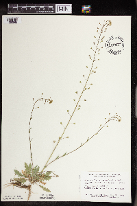 Capsella bursa-pastoris (L.) Medikus 745081[1352565]Smith, Welby 38691981-05-22 United States, Minnesota, Wright, Wright Co. Lake Maria State Park, about 1.5 mi E of Silver Creek; SW1/4 SW1/4 Sec. 3 T121N R26W;Lake Maria State Park;121N;26W;3, 45.318402 -93.942357 |
MIN:Plants | Capsella bursa-pastoris (L.) Medikus 746977[]Jordan, s.n. United States, Minnesota, Stearns, St. Cloud;;N;;, 45.55 -94.166667 |
MIN:Plants | Capsella bursa-pastoris (L.) Medikus 764370[]Foote, Lewis s.n.1886-06-07 United States, Minnesota, Nobles, Worthington;;N;;, 43.619964 -95.596398 |
MIN:Plants | Capsella bursa-pastoris (L.) Medikus 764371[]Foote, Lewis s.n.1893-07-00 United States, Minnesota, Nobles, Worthington;;N;;, 43.619964 -95.596398 |
MIN:Plants | Capsella bursa-pastoris (L.) Medikus 764430[]Hart, H. s.n.1922-06-08 United States, Minnesota, Hennepin, Bedford St, Minneapolis;;N;;, 44.96539 -93.20871 |
MIN:Plants | 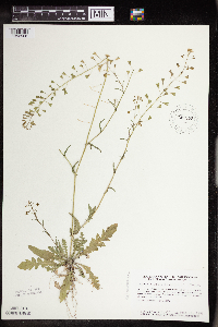 Capsella bursa-pastoris (L.) Medikus 787672[1352568]Smith, Welby 104751985-06-16 United States, Minnesota, Ramsey, Ramsey County ... At the corner of Plato Boulevard & Wabasha Avenue in the city St. Paul ... SE1/4 SE1/4 Sec 6 T28N R22W;;028N;22W;06, 44.941314 -93.095877 |
MIN:Plants | 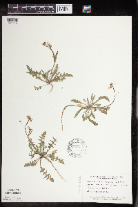 Capsella bursa-pastoris (L.) Medikus 795965[1352564]Smith, Welby 76791983-05-18 United States, Minnesota, Wright, Wright Co. Lake Maria State Park, about 1.5 mi E of Silver Creek; SW1/4 SW1/4 Sec. 3 T121N R26W;Lake Maria State Park;121N;26W;3, 45.318402 -93.942357 |
MIN:Plants | Capsella bursa-pastoris (L.) Medikus 801146[]Smith, Welby 106661985-07-11 United States, Minnesota, Goodhue, In the Cannon River, ca. 2.5 mi. E of Welch. SW1/4 SW1/4 Sec. 25, T113N, R16W.;Dorer Memorial Hardwood State Forest;113N;16W;25, 44.564651 -92.562251 |
MIN:Plants | Capsella bursa-pastoris (L.) Medikus 801148[]Smith, Welby 100661985-05-02 United States, Minnesota, Fillmore, Fillmore County ... Deer Creek Valley, about 4 mi NW of Wykoff. NE1/4 NW1/4 Sec. 13, T103N, R13W;;103N;13W;13, 43.7316666 -92.3419418 |
MIN:Plants | Capsella bursa-pastoris (L.) Medikus 802711[]Smith, Welby 114041986-05-14 United States, Minnesota, Dodge, Dodge County ... Iron Horse Prairie State SNA, about 1 1/2 mi. S of Hayfield ... NW1/4 SE1/4 Sec. 27, T105N, R17W;Iron Horse Prairie Scientific Natural Area;105N;17W;27, 43.8675003 -92.8486099 |
MIN:Plants | Capsella bursa-pastoris (L.) Medikus 802747[]Smith, Welby 114931986-05-24 United States, Minnesota, Scott, Minnesota Valley National Wildlife Refuge. Scott Co. The Louisville Swamp area, in the Minnesota Valley National Wildlife Refuge; ca. 6 mi. S of Shakopee. NW1/4 S Scott Co. The Louisville Swamp area, in the Minnesota Valley National Wildlife Refuge; ca. 6 mi. S of Shakopee. NW1/4 SW1/4 Sec. 28, T115N, R23W. 115N 23W 28, 44.7355537 -93.5988922 |
MIN:Plants | Capsella bursa-pastoris (L.) Medikus 812564[]Wheeler, Gerald 111751988-07-18 United States, Minnesota, Big Stone, Graceville (SW side); ca. 0.5 mi. W of Rte. 75, near East Toqua Lake. Near parking area. NW1/4 Sec. 16, T124N, R46W.;;124N;46W;16, 45.550417 -96.442385 |
MIN:Plants | Capsella bursa-pastoris (L.) Medikus 812687[]Wheeler, Gerald 109001988-06-26 United States, Minnesota, Traverse, Ca. 5.5. mi. SW of Wheaton; wayside park N ot Rte. 27. W1/2 NE1/4 Sec. 32. T127N, R47W (Lake Twp.).;;127N;47W;32, 45.767018 -96.604078 |
MIN:Plants | Capsella bursa-pastoris (L.) Medikus 815137[]Wheeler, Gerald 105261988-05-27 United States, Minnesota, Norman, Ca. 1 mi. W of Halstad; roadside park S of Rte. 200. W1/2 NE1/4 Sec. 25, T145N, R49W (Halstad Twp.);;145N;49W;25, 47.347671 -96.840153 |
MIN:Plants | Capsella bursa-pastoris (L.) Medikus 815195[]Wheeler, Gerald 114111988-07-25 United States, Minnesota, Lac Qui Parle, Lac Qui Parle State Park. Ca. 15 mi. E of Madison; Lac Qui Parle State Park, NE of Rte. 33. Near parking lot for beach access. N1/2 E1/2 Sec. 15 Ca. 15 mi. E of Madison; Lac Qui Parle State Park, NE of Rte. 33. Near parking lot for beach access. N1/2 E1/2 Sec. 15, T118N, R42W (Lac Qui Parle Twp.). 118N 42W 15, 45.029904 -95.909318 |
Google Map
Google Maps is a web mapping service provided by Google that features a map that users can pan (by dragging the mouse) and zoom (by using the mouse wheel). Collection points are displayed as colored markers that when clicked on, displays the full information for that collection. When multiple species are queried (separated by semi-colons), different colored markers denote each individual species.