University of Minnesota
http://www.umn.edu/
612-625-5000
http://www.umn.edu/
612-625-5000
Minnesota Biodiversity Atlas
Bell Museum
Dataset: MIN-Plants
Taxa: Brassicaceae
Search Criteria: excluding cultivated/captive occurrences
Bell Museum plants | |
 MIN:Plants | 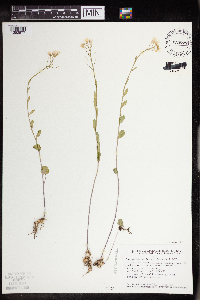 Cardamine bulbosa (Schreber ex Muhlenberg) Britton, Sterns & Poggenburg 833727[1352577]Smith, Welby 140931988-05-30 United States, Minnesota, Lac Qui Parle, Lac Qui Parle County...About 3 mi west of Montevideo...ravine that drains north into the Minnesota River. NE1/4 NE1/4 section 21, T 117N R 41W. 117N 41W 21, 44.9166667 -95.8 |
MIN:Plants | Cardamine bulbosa (Schreber ex Muhlenberg) Britton, Sterns & Poggenburg 833789[]Smith, Welby 140791988-05-21 United States, Minnesota, Washington, Belwin Outdoor Education Laboratory. Washington Co.; Belwin Outdoor Education Laboratory, about 1 1/2 mi west of Lake St. Croix Beach; SW1/4 SW1/4 Sec 10, T28N R20W.. 028N 20W 10, 44.927188 -92.791852 |
MIN:Plants |  Cardamine bulbosa (Schreber ex Muhlenberg) Britton, Sterns & Poggenburg 837250[1352578]Smith, Welby 187011991-06-07 United States, Minnesota, Morrison, Camp Ripley Military Reservation. Camp Ripley Military Reservation. Morrison County...Hole in Day Marsh, south of Cunningham Road, about 250 meters east of its junction with Bennet Road...UTM: 391900E 5111700N T131N R30W NW1/4 of NE1/4 of Sec 25. 131N 30W 25, 46.129341 -94.401575 |
MIN:Plants |  Cardamine bulbosa (Schreber ex Muhlenberg) Britton, Sterns & Poggenburg 840481[1352575]Boe, J. 930612031993-06-12 United States, Minnesota, Cass, Cass County...Shingobee River...T 141N R 31W NE1/4 of SW1/4 of Sec 15.;Chippewa National Forest;141N;31W;15, 47.031926 -94.587246 |
MIN:Plants | Cardamine bulbosa (Schreber ex Muhlenberg) Britton, Sterns & Poggenburg 841015[]Smith, Welby 127201987-05-20 United States, Minnesota, Pipestone, Altona Wildlife Management Area. Pipestone County...Altona State Wildlife Management Area, about 1.5 mi southeast of Verdi...NW1/4 NW1/4 sec. 1, T108N R46W. 108N 46W 1, 44.1966667 -96.325 |
MIN:Plants | Cardamine bulbosa (Schreber ex Muhlenberg) Britton, Sterns & Poggenburg 443878[]Mensing, D. 96-911996-06-28 United States, Minnesota, Hubbard, Hubbard Co. T139N R34W SW1/4 of the SE1/4 of S30; floodplain of Shell river north of Upper Twin Lake;;139N;34W;30, 46.827257 -95.027348 |
MIN:Plants |  Cardamine bulbosa (Schreber ex Muhlenberg) Britton, Sterns & Poggenburg 443879[1352576]Mensing, D. 96-521996-06-11 United States, Minnesota, Isanti, Anoka Co. T34N R23W SW1/4 of the SE1/4 of S21 [this locale is in Isanti Co. not Anoka]...floodplain of Cedar Creek;Cedar Creek National History Area;034N;23W;21, 45.421163 -93.214653 |
MIN:Plants | Cardamine bulbosa (Schreber ex Muhlenberg) Britton, Sterns & Poggenburg 269323[]Moore, John 17751923-06-00 United States, South Dakota, Brookings, Brookings;;;;, 44.31139 -96.79806 |
MIN:Plants | Cardamine bulbosa (Schreber ex Muhlenberg) Britton, Sterns & Poggenburg 599327[]Tryon, R. 45941936-04-18 United States, Indiana, Porter, Indiana Dunes State Park, 3 miles N of Chesterton, Porter Co.;Indiana Dunes National Lakeshore;;;, 41.663093 -87.032128 |
MIN:Plants | Cardamine bulbosa (Schreber ex Muhlenberg) Britton, Sterns & Poggenburg 800543[]Larson, Gary 99861986-05-27 United States, South Dakota, Deuel, Deuel County...T 115N, R 48W, Sec. 6, SW1/4; Crystal Springs Ranch...above Monaghan Creek drainage;;115N;48W;06 |
MIN:Plants | Cardamine bulbosa (Schreber ex Muhlenberg) Britton, Sterns & Poggenburg 914617[]Smith, Welby 226691993-07-01 United States, Minnesota, Otter Tail, Otter Tail County ... On the north side of CSAH 38; 0.8 mile east of its junction with TH 78, and about 11 miles south of Battle Lake (town) ... T131N R40W SE1/4 of SE1/4 of Sec 22. 131N 40W 22, 46.1380556 -95.6908333 |
MIN:Plants | 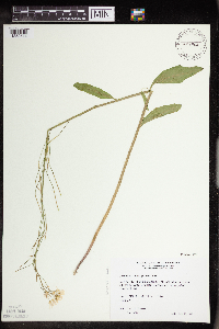 Cardamine bulbosa (Schreber ex Muhlenberg) Britton, Sterns & Poggenburg 459968[1352574]Wheeler, Gerald 160741997-06-10 United States, Minnesota, Renville, Renville County...Ca. 3 mi. SE of Franklin on Rte. 5, S of road...S1/2 NW1/4 Sec. 20 T112N R33W (Camp 20);;112N;33W;20, 44.488589 -94.842347 |
MIN:Plants | Cardamine bulbosa (Schreber ex Muhlenberg) Britton, Sterns & Poggenburg 931644[]Smith, Welby R. 201421992-05-12 United States, Minnesota, Le Sueur, about 2 miles east of Waterville. NW of NE of section;Sakatah Lake State Park;109N;23;25, 44.2241667 -93.5294444 |
MIN:Plants | Cardamine bulbosa (Schreber ex Muhlenberg) Britton, Sterns & Poggenburg 931713[]Smith, Welby R. 203041992-06-02 United States, Minnesota, Pipestone, About 2 miles northeast of Holland SE of SW of section;;108N;44W;32, 44.1125 -96.1569444 |
MIN:Plants | Cardamine bulbosa (Schreber ex Muhlenberg) Britton, Sterns & Poggenburg 931720[]Smith, Welby R. 203121992-06-02 United States, Minnesota, Murray, About 8 miles north of Slayton NW of NW of section;;107N;41W;04, 44.1072222 -95.7791667 |
MIN:Plants | Cardamine bulbosa (Schreber ex Muhlenberg) Britton, Sterns & Poggenburg 933534[]Smith, Welby R. 204941992-06-20 United States, Minnesota, Wadena, On the north side of a gravel road, about one mile west of Manahga. SE1/4 of NE1/4 of section;;138N;35W;20, 46.7547222 -95.1216667 |
MIN:Plants | Cardamine bulbosa (Schreber ex Muhlenberg) Britton, Sterns & Poggenburg 397610[]Anderson, Derek S. 11232009-05-28 United States, Minnesota, Mower, Cartney Wildlife Management Area, about 6km north of Le Roy. T101N R14W E 1/2 of Sec. 05, 43.582278 -92.53437 |
MIN:Plants | 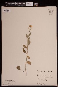 Cardamine bulbosa (Schreber ex Muhlenberg) Britton, Sterns & Poggenburg 952370[1292219]Bunday, J. s.n.1940-05-25 United States, Minnesota, Rice, Nerstrand Woods State Park, 44.340927 -93.11159 |
MIN:Plants | 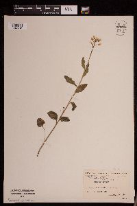 Cardamine bulbosa (Schreber ex Muhlenberg) Britton, Sterns & Poggenburg 952372[1292218]Carleton College Class s.n. United States, Minnesota, Rice, Nerstrand Woods State Park, 44.340927 -93.11159 |
MIN:Plants | 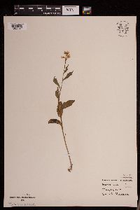 Cardamine bulbosa (Schreber ex Muhlenberg) Britton, Sterns & Poggenburg 952371[1292217]Nelson, Quint s.n.1940-05-25 United States, Minnesota, Rice, Nerstrand, 44.341909 -93.067988 |
MIN:Plants | 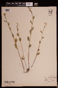 Cardamine bulbosa (Schreber ex Muhlenberg) Britton, Sterns & Poggenburg 952373[1292216]Maas, Ada s.n.1928-05-14 United States, Minnesota, Rice, Dundas, 44.429409 -93.201883 |
MIN:Plants | 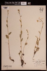 Cardamine bulbosa (Schreber ex Muhlenberg) Britton, Sterns & Poggenburg 952369[1292215]Fauskee, Alice M. s.n.1928-05-14 United States, Minnesota, Rice, Dundas, 44.429409 -93.201883 |
MIN:Plants | 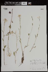 Cardamine bulbosa (Schreber ex Muhlenberg) Britton, Sterns & Poggenburg 952905[1294941]Anderson, Derek S. 24532015-06-02 United States, Minnesota, Swift, 45.15 -95.94 |
MIN:Plants | 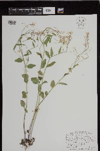 Cardamine bulbosa (Schreber ex Muhlenberg) Britton, Sterns & Poggenburg 949708[1297305]Smith, Welby R. 33571 United States, Minnesota, Freeborn |
MIN:Plants | 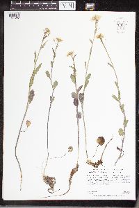 Cardamine bulbosa (Schreber ex Muhlenberg) Britton, Sterns & Poggenburg 960967[1334050]Anderson, Derek S. 25282016-05-16 United States, Minnesota, Brown, Cottonwood River Prairie SNA, About 1.8 km east of Sanborn. East of the Redwood/Brown County line, and south-southeast of the intersection of 460th Ave. and 170th St. W., 44.21 -95.11 |
MIN:Plants | 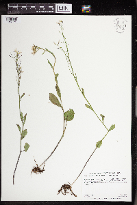 Cardamine bulbosa (Schreber ex Muhlenberg) Britton, Sterns & Poggenburg 963560[1352175]Graham, Dustin R. DRJG1352018-06-06 United States, Minnesota, Norman, 7.5 miles southwest of Garfield, MN., 47.45 -96.38, 992m |
MIN:Plants | 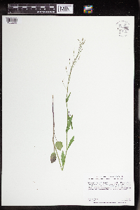 Cardamine bulbosa (Schreber ex Muhlenberg) Britton, Sterns & Poggenburg 963598[1352213]Graham, Dustin R. DRJG792017-06-13 United States, Minnesota, Lyon, Plants located in Gavin County Park along west bank of the cottonwood River, 9.2 km northwest of Tracy, MN., 44.27 -95.74, 1334m |
MIN:Plants | 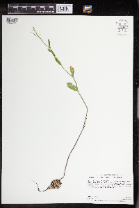 Cardamine bulbosa (Schreber ex Muhlenberg) Britton, Sterns & Poggenburg 963604[1352219]Graham, Dustin R. DRJG842017-06-13 United States, Minnesota, Rock, Growing on the east side of Blue Mounds State park, located 5.5 km north-northeast of Laverne, MN., 43.71 -96.18, 1480m |
MIN:Plants | 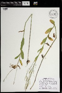 Cardamine bulbosa (Schreb. ex Muhl.) Britton, Sterns & Poggenb. 970755[1394236]Smith, Welby R WRS356952017-06-13 United States, Minnesota, Dodge, 10.6 km (6.6 miles) east of approximate center of the town of Hayfield at heading of 86 degrees., 43.8968056 -92.7145556 |
MIN:Plants |  Cardamine bulbosa (Schreb. ex Muhl.) Britton, Sterns & Poggenb. 970785[1394266]Smith, Welby R WRS357252017-06-15 United States, Minnesota, Dakota, A calcareous fen in a large wetland complex in Burnsville., 44.7333611 -93.3184444 |
MIN:Plants | Cardamine bulbosa (Schreb. ex Muhl.) Britton, Sterns & Poggenb. []Timothy J. S. Whitfeld 35222023-05-10 United States, Minnesota, Washington, Crystal Spring Scientific and Natural Area, 0.4 miles northeast of the intersection of Scandia Trail North and Hwy 95, 45.25689 -92.76443, 218m |
MIN:Plants | Cardamine bulbosa (Schreb. ex Muhl.) Britton, Sterns & Poggenb. []J. C. B. Waddington 461966-05-21 United States, Minnesota, Dakota, Nicols meadow (Cedar Ave S.) T27N, R20W, Sect. 18, 44.82584 -93.217838 |
MIN:Plants | Cardamine bulbosa (Schreb. ex Muhl.) Britton, Sterns & Poggenb. []J. C. B. Waddupton 461966-05-21 United States, Minnesota, Dakota, Nicols meadow (Cedar Ave S.) T27N R20W, Sect.18; 44.827362 -93.221186, 44.827362 -93.221186 |
MIN:Plants | 630448[]Halse, Richard 7781972-03-29 United States, Arizona, Apache, N.P.S. trailers south of the headquarters of Canyon de Chelly National Monument; T5N, R10W, Sec.22;Canyon de Chelly National Monument;005N;10W;22, 1689m |
MIN:Plants |  462233[1352606]Lee, Michael MDL26241999-07-26 United States, Minnesota, Lake, North Shore. Lake County ... along shore of Lake Superior 1/4 mile northeast of the Manitou River mouth, four miles northeast of Little Marais ... cliff rising out of the lake ... T57N R6W SE1/4 of SW1/4 Sec. 2. 057N 06W 2, 47.451956 -91.057756 |
MIN:Plants | 364757[]Jacobs, D. 31939-07-07 Canada, Ontario, Thunder Bay, Thunder Bay District...Cloud Bay |
MIN:Plants |  444319[1352607]Gerdes, Lynden; et al. 25221998-05-25 United States, Minnesota, Cook, Superior National Forest. T64N R03E S11SWSE. Cook Co.; Superior National Forest. Along the Border Route hiking trail between John Lake and South F T64N R03E S11SWSE. Cook Co.; Superior National Forest. Along the Border Route hiking trail between John Lake and South Fowl Lake.. 064N 03E 11, 48.043396 -90.022127 |
MIN:Plants |  444322[1352602]Gerdes, Lynden 25851998-06-03 United States, Minnesota, Cook, T65N R01E S27 SWNE. Cook Co.; Superior National Forest, BWCAW, Clearwater Lake. Cliff 3.;Boundary Waters Canoe Area Wilderness / Superior National Forest;065N;01E;27, 48.083795 -90.312958 |
MIN:Plants | 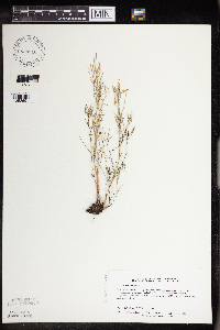 829916[1352601]Delaney, B. 910601991-06-03 United States, Minnesota, Benton, Benton Co.; E side of Co.Rd.6, 2.5 mi S of Morrison-Benton Co. line, Granite Ledge Twp, NW1/4 SW1/4 sec.17, T38N, R28W;;038N;28W;17, 45.785868 -93.854943 |
MIN:Plants | 118316[]Sandberg, John s.n.1885-06-00 United States, Minnesota, Chisago, Taylors Falls;Saint Croix National Riverway;034N;19W;25, 45.404742 -92.662229 |
MIN:Plants | 118317[]Campbell, Jennie C1441896-07-00 United States, Minnesota, Stearns, St. Cloud;;;;, 45.55 -94.166667 |
MIN:Plants | 284024[]Butters, F.; et al. 4081932-07-13 United States, Minnesota, Cook, Cliff S side Clearwater Lake;Boundary Waters Canoe Area Wilderness / Superior National Forest;065N;01E;, 48.081055 -90.315189 |
MIN:Plants | 360395[]Lakela, Olga 35721940-06-16 United States, Minnesota, Saint Louis, Above Beck's highway near Fond du Lac Junction, Duluth;;;;, 46.659664 -92.273248 |
MIN:Plants | 362401[]Lakela, Olga 36891940-07-05 United States, Minnesota, Cook, Windigo Point, Sea Gull Lake;Boundary Waters Canoe Area Wilderness / Superior National Forest;065N;05W;, 48.149256 -90.887916 |
MIN:Plants | 362448[]Lakela, Olga 24551938-06-10 United States, Minnesota, Saint Louis, Skyline Parkway, 30th Ave. N, Duluth;;;;, 46.75882 -92.1362 |
MIN:Plants | 386002[]Lakela, Olga 56421944-08-04 United States, Minnesota, Saint Louis, Esquagama Lake;;;;, 47.467001 -92.356147 |
MIN:Plants | 394072[]Butters, F.; et al. 741936-06-21 United States, Minnesota, Cook, Cliffs on S side of and toward W end of Clearwater Lake; T65N R1E;Boundary Waters Canoe Area Wilderness / Superior National Forest;065N;01E;, 48.081055 -90.315189 |
MIN:Plants | 394073[]Butters, F.; et al. 1031940-07-01 United States, Minnesota, Cook, W side of North Fowl Lake...T65N R3E;Boundary Waters Canoe Area Wilderness / Superior National Forest;065N;03E;, 48.081607 -90.076407 |
MIN:Plants | 394074[]Butters, F.; et al. 6231940-06-29 United States, Minnesota, Cook, On W side of island on W side of South Fowl Lake; T64N R3E;Superior National Forest;064N;03E;, 48.018792 -90.055527 |
MIN:Plants | 394109[]Butters, F.; et al. 2971937-07-06 United States, Minnesota, Cook, Between cliffs, S side of Mountain Lake; T65N R1E;Boundary Waters Canoe Area Wilderness / Superior National Forest;065N;01E;, 48.081055 -90.315189 |
MIN:Plants | 394110[]Butters, F.; et al. 1211936-06-25 United States, Minnesota, Cook, Point on N side of Clearwater Lake; T65N R1E;Boundary Waters Canoe Area Wilderness / Superior National Forest;065N;01E;, 48.081055 -90.315189 |
MIN:Plants | 394111[]Butters, F.; et al. 105a1936-06-23 United States, Minnesota, Cook, Overlooking Watab Lake; T65N R1E;Boundary Waters Canoe Area Wilderness / Superior National Forest;065N;01E;, 48.081055 -90.315189 |
MIN:Plants | 394112[]Butters, F.; et al. 2601937-07-04 United States, Minnesota, Cook, On S side of and toward W end of Mountain Lake; T65N R1E;Boundary Waters Canoe Area Wilderness / Superior National Forest;065N;01E;, 48.081055 -90.315189 |
MIN:Plants | 394113[]Butters, F.; et al. 1661936-06-28 United States, Minnesota, Cook, Top of Mt. Josephine, near Grand Portage; T63N R6E [sic, actually in T64];Grand Portage Indian Reservation / North Shore;064N;06E;34, 47.983098 -89.66244 |
MIN:Plants | 394114[]Butters, F.; et al. 2421937-07-02 United States, Minnesota, Cook, Cook County...Watab Lake. Twp. 65N R. 1E;Boundary Waters Canoe Area Wilderness / Superior National Forest;065N;01E;, 48.081055 -90.315189 |
MIN:Plants | 394115[]Dahl, A. 125C1945-06-19 United States, Minnesota, Cook, Cliff 2B, S shore, Clearwater lake; T65N R1E;Boundary Waters Canoe Area Wilderness / Superior National Forest;065N;01E;, 48.081055 -90.315189 |
MIN:Plants | 394116[]Burns, G.; et al. 2831938-07-27 United States, Minnesota, Cook, Cliff along South Fowl Lake; T64N R3E. Cook Co.;Pigeon River Cliffs, The Nature Conservancy / Superior National Forest;064N;03E;11, 48.043396 -90.022127 |
MIN:Plants | 394117[]Burns, G.; et al. 3631938-07-29 United States, Minnesota, Cook, Cliff 3/8 mi E of source of Royal River; T64N R3E;Superior National Forest;064N;03E;, 48.018792 -90.055527 |
MIN:Plants | 394118[]Burns, G.; et al. 2161938-07-22 United States, Minnesota, Cook, Cliff N of center of East Pike Lake; T65N R3E;Boundary Waters Canoe Area Wilderness / Superior National Forest;065N;03E;, 48.081607 -90.076407 |
MIN:Plants | 394119[]Burns, G.; et al. 1771938-07-20 United States, Minnesota, Cook, Cliff 3/4 mi N of middle of West Pike Lake; T65N R2E;Boundary Waters Canoe Area Wilderness / Superior National Forest;065N;02E;, 48.086124 -90.186483 |
MIN:Plants | 394120[]Butters, F.; et al. s.n.1935-06-29 United States, Minnesota, Cook, Cook County...Cliffs, Clearwater Lake. Twp. 65N R. 1E;Boundary Waters Canoe Area Wilderness / Superior National Forest;065N;01E;00, 48.081055 -90.315189 |
MIN:Plants | 407582[]Lakela, Olga 8229a1949-06-07 United States, Minnesota, Saint Louis, 40th Ave. W, Skyline Parkway, Duluth;;;;, 46.75817 -92.16362 |
MIN:Plants | 420675[]Lakela, Olga 105041950-06-18 United States, Minnesota, Saint Louis, The new University [of Minnesota] Campus, Duluth;;050N;14W;14, 46.814884 -92.079219 |
MIN:Plants | 462501[]Lakela, Olga 150121952-07-14 United States, Minnesota, Saint Louis, Kabetogama Lake, opposite Pine Island;Voyageurs National Park;;;, 48.41994 -92.92786 |
MIN:Plants | 462834[]Lakela, Olga 144531952-06-24 United States, Minnesota, Saint Louis, island in Namakan Lake just off the Narrows, Minnesota-Ontario boundary;Voyageurs National Park;;;, 48.43053 -92.49014 |
MIN:Plants | 463032[]Lakela, Olga 142941952-06-19 United States, Minnesota, Saint Louis, Gull Island in Namakan Lake, 5 mi from the Narrows;Voyageurs National Park;;;, 48.43053 -92.49014 |
MIN:Plants | 463078[]Lakela, Olga 141161952-06-16 United States, Minnesota, Saint Louis, Namakan Lake, at the Narrows;Voyageurs National Park;;;, 48.43053 -92.49014 |
MIN:Plants | 519004[]Smith, Welby 15434A1989-06-20 United States, Minnesota, Lake, Boundary Waters Canoe Area Wilderness / Superior National Forest. Lake County...Boundary Waters Canoe Area Wilderness, Superior National Forest; on South Arm Knife Lake at the end of the portage from Sema Lake; NE1/4 NW1/4 sec.30, T 65N R 6W. 065N 06W 30, 48.085334 -91.150039 |
MIN:Plants | 527242[]Lakela, Olga 173511954-06-08 United States, Minnesota, Saint Louis, On Lake Vermilion Road near Vermilion River dam;Superior National Forest;;;, 47.96188 -92.47516 |
MIN:Plants | 702040[]Sather, Nancy; et al. 3551977-06-01 United States, Minnesota, Lake, Lake Co. Near Heart lake, plot G26; SE1/4 SW1/4 Sec. 7 T61N R10W;Superior National Forest;061N;10W;07, 47.784061 -91.651781 |
MIN:Plants | 772300[]Boe, J. 3161979-06-21 United States, Minnesota, Lake of the Woods, 7 Mile Corner W of Norris Camp; T159N R36W SE1/4 Sec. 18 and NE1/4 Sec. 19;;159N;36W;00, 48.58343 -95.277166 |
MIN:Plants | 773419[]Boe, J. 1341979-06-13 United States, Minnesota, Lake of the Woods, Lake of the Woods County...Lost Lake Trail...T159N R35W Sec. 29;;159N;35W;29, 48.561788 -95.18093 |
MIN:Plants | 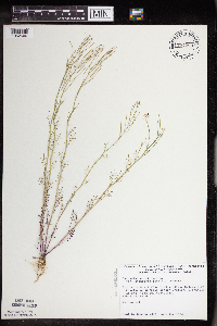 774289[1352600]Monson, Paul 53031983-06-14 United States, Minnesota, Saint Louis, Voyageurs National Park, Kabetogama Narrows Ranger Station...T69N R20W SW1/4 NW1/4 Sec. 25;Voyageurs National Park;069N;20W;25, 48.43325 -92.842322 |
MIN:Plants | 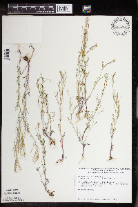 774290[1352604]Monson, Paul 54231983-06-18 United States, Minnesota, Saint Louis, Voyageurs National Park, Lake Kabetogama, N shore, beach to W; T69N R20W SE1/4 Sec. 16;Voyageurs National Park;069N;20W;16, 48.462947 -92.906935 |
MIN:Plants | 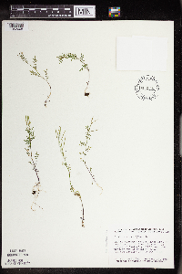 804565[1352605]Smith, Welby 118731986-06-23 United States, Minnesota, Cook, Boundary Waters Canoe Area Wilderness / Superior National Forest. Cook County...Boundary Waters Canoe Area of the Superior National Forest, near the western end of Mountain Lake NW1/4 SE1/4 Sec. 23 T65N R1E. 065N 01E 23, 48.096403 -90.291084 |
MIN:Plants | 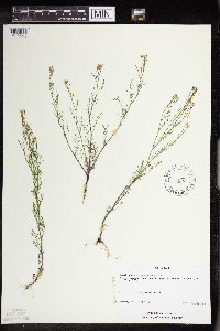 436857[1352603]Schimpf, D. DJS3552004-06-10 United States, Minnesota, Saint Louis, St. Louis County, Midway Township. T49N R15W SE1/4 of NW1/4 Sec 33;;049N;15W;33, 46.6855556 -92.2508333 |
MIN:Plants | 225526[]Rosendahl, C. 52391927-05-28 United States, Wisconsin, Polk, InterState Park. Taylors Falls - St. Croix Falls;Interstate State Park;;;, 45.426173 -92.644787 |
MIN:Plants | 928692[]Anderson, Rebecca; Gerdes, D. Lawson 00172008-07-24 United States, Minnesota, Saint Louis, Approx. 0.7 km W of northern tip of Angleworm Lake; 1.1 km SW of Home Lake. SESE of section.;Boundary Waters Canoe Area Wilderness / Superior National Forest;065N;12W;17, 48.1105556 -91.8891667 |
MIN:Plants | 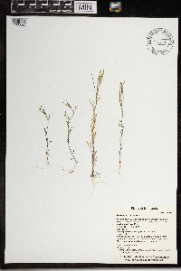 0967481[1368026]T. J. S. Whitfeld 20852019-06-13 United States, Minnesota, Lake, Boundary Waters Canoe Area Wilderness, small island at the east end of Lake Four, 47.9025 -91.395056, 454m |
MIN:Plants | 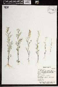 968028[1368590]T. J. S. Whitfeld 22102019-06-19 United States, Minnesota, Lake, Boundary Waters Canoe Area Wilderness, north shoreline of Fish Dance Lake towards the western end of the lake, 47.916139 -91.216528, 473m |
MIN:Plants | 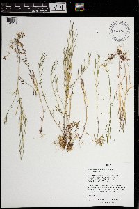 971282[1394759]M. H. Nee 654882020-05-05 United States, Wisconsin, Iowa, 7km (straight line) NE of Dodgeville, Governor Dodge State Park. T 6 N; R 3 E; NE¼NW¼ sect. 11., 43.017222 -90.105278, 337m |
MIN:Plants |  973377[1398930]Lee, Michael MDL58952012-06-14 United States, Minnesota, Lake, Rugged bedrock terrain north of the Fernberg Road, near the southwest end of Moose Lake, 15 miles east-southeast of Ely., 47.9744124996 -91.532001482, 451m |
MIN:Plants | Boechera stricta (Graham) Al-Shehbaz 117246[]Nelson, Aven; et al. 58271899-07-14 United States, Wyoming, Park, Yellowstone National Park...Soda Butte Creek;Yellowstone National Park |
MIN:Plants | Boechera stricta (Graham) Al-Shehbaz 919595[]Smith, Welby 222761993-06-03 United States, Minnesota, Sibley, Vale Wildlife Management Area. Sibley County ... Vale State Wildlife Management Area; in the valley of High Island Creek, about 2.5 miles southwest of its confluence with the Minnesota River ... T113N R26W NE1/4 of SW1/4 of Sec 27. 113N 26W 27, 44.5625 -93.9427778 |
MIN:Plants | Boechera stricta (Graham) Al-Shehbaz 304658[]Elmer, A.D.E. 26931900-07-00 United States, Washington, Clallam, Olympic Mts. [Olympic National Park], 47.83 -123.83 |
MIN:Plants | Boechera stricta (Graham) Al-Shehbaz 117239[]Elmer, A.D.E. 26931900-06-00 United States, Washington, Clallam, Olympic Mts. [Olympic National Park], 47.83 -123.83 |
MIN:Plants | Boechera stricta (Graham) Al-Shehbaz 225501[]Stork, H.; et al. 451925-07-11 United States, Montana, Glacier Natl. Park;Glacier National Park |
MIN:Plants | Boechera stricta (Graham) Al-Shehbaz 117256[]Aiton, G. s.n.1891-05-00 United States, Minnesota, Hennepin, near Minneapolis;;029N;24W;, 44.991926 -93.288153 |
MIN:Plants | Boechera stricta (Graham) Al-Shehbaz 337031[]Lakela, Olga 14191936-06-13 United States, Minnesota, Saint Louis, S.E. of the old lighthouse ruins, Sec. 20. U.S. Government Property, Duluth;Minnesota Point;049N;13W;20, 46.741215 -92.062388 |
MIN:Plants | Boechera stricta (Graham) Al-Shehbaz 353297[]Lakela, Olga 24591938-06-11 United States, Minnesota, Saint Louis, Skyline Parkway near Haines Road, Duluth;;;;, 46.75817 -92.16362 |
MIN:Plants | Boechera stricta (Graham) Al-Shehbaz 353674[]Lakela, Olga 23931938-05-28 United States, Minnesota, Lake, Silver Creek on Highway 61. Lake Co.;North Shore;053N;10W;21, 47.063539 -91.615863 |
MIN:Plants | Boechera stricta (Graham) Al-Shehbaz 356198[]Lakela, Olga 29201939-06-08 United States, Minnesota, Saint Louis, 44th Ave. W, Skyline Parkway, Duluth.;;;;, 46.75116 -92.16167 |
MIN:Plants | Boechera stricta (Graham) Al-Shehbaz 356255[]Lakela, Olga 31471939-07-15 United States, Minnesota, Lake, Top of the Great Palisade [=Palisade Head] on Lake Superior, 65 mi N of Duluth;North Shore / Palisade Head;056N;07W;22, 47.32413 -91.213641 |
MIN:Plants | Boechera stricta (Graham) Al-Shehbaz 386901[]Hero, C. s.n.1940-05-20 United States, Minnesota, Renville, Near Minn.River, 12 mi S.W. of Renville;;115N;37W;, 44.759795 -95.299697 |
MIN:Plants | Boechera stricta (Graham) Al-Shehbaz 407594[]Lakela, Olga 82311949-06-07 United States, Minnesota, Saint Louis, 40th Ave. West, Skyline Parkway, Duluth.;;;;, 46.75817 -92.16362 |
MIN:Plants | Boechera stricta (Graham) Al-Shehbaz 566725[]Lang, H.; et al. 21878-04-12 United States, Minnesota, Hennepin, Minneapolis;;029N;24W;25, 44.96996 -93.23702 |
MIN:Plants | Boechera stricta (Graham) Al-Shehbaz 117157[]Ainslie, G. 17801902-05-19 United States, Minnesota, Olmsted, Back of cemetery, Rochester;;106N;14W;00, 43.97834 -92.498342 |
MIN:Plants | Boechera stricta (Graham) Al-Shehbaz 117397[]Rosendahl, C.; et al. 40121922-06-17 United States, Minnesota, Yellow Medicine, Granite Falls;;116N;39W;, 44.809958 -95.545575 |
MIN:Plants | Boechera stricta (Graham) Al-Shehbaz 117463[]Manning, Sara s.n.1883-06-25 United States, Minnesota, Wabasha, Lake City;;N;;, 44.44402 -92.273367 |
MIN:Plants | Boechera stricta (Graham) Al-Shehbaz 353377[]Moyle, J. 13791934-07-14 United States, Minnesota, Hubbard, Near Badoura;;N;;, 46.862181 -94.766121 |
Google Map
Google Maps is a web mapping service provided by Google that features a map that users can pan (by dragging the mouse) and zoom (by using the mouse wheel). Collection points are displayed as colored markers that when clicked on, displays the full information for that collection. When multiple species are queried (separated by semi-colons), different colored markers denote each individual species.