University of Minnesota
http://www.umn.edu/
612-625-5000
http://www.umn.edu/
612-625-5000
Minnesota Biodiversity Atlas
Bell Museum
Dataset: MIN-Plants
Taxa: Brassicaceae
Search Criteria: excluding cultivated/captive occurrences
Bell Museum plants | |
 MIN:Plants | Boechera stricta (Graham) Al-Shehbaz 420577[]Lakela, Olga 107261950-07-16 United States, Minnesota, Saint Louis, Below Skyline Parkway, 39th Ave, W Duluth;;N;;, 46.754089 -92.152248 |
MIN:Plants |  Boechera stricta (Graham) Al-Shehbaz 508488[1352529]Lee, Michael MDL10211995-06-14 United States, Minnesota, Wabasha, Dorer Memorial Hardwood State Forest. Wabasha County...bluffs along the Zumbro River 1 1/2 mi NNE of Rattlesnake Point. 2 1/2 mi ENE of South Troy...T109N R14W SWNENE 27. 109N 14W 27, 44.216363 -92.481106 |
MIN:Plants | Boechera stricta (Graham) Al-Shehbaz 550324[]Cotter, Shirley 19111951-06-15 United States, Minnesota, Washington, Washington Co.; Hay Lake, E of Forest Lake;;032N;21W;, 45.253532 -92.958232 |
MIN:Plants | Boechera stricta (Graham) Al-Shehbaz 583415[]Kellner, H. 5171956-06-14 United States, Minnesota, Cook, Cook Co.; Slope of Rose Mt, Grand Portage;Grand Portage National Monument / North Shore;063N;06E;, 47.958468 -89.703576 |
MIN:Plants | Boechera stricta (Graham) Al-Shehbaz 614586[]Westkaemper, Remberta s.n.1968-05-00 United States, Minnesota, Stearns, Stearns Co. Cold Spring;;123N;30W;, 45.456498 -94.4449 |
MIN:Plants | Boechera stricta (Graham) Al-Shehbaz 614636[]Westkaemper, Remberta s.n.1967-08-00 United States, Minnesota, Stearns, Stearns Co. SBC [St. Benedict College] Woods, St. Joseph;;124N;29W;, 45.543642 -94.322053 |
MIN:Plants | Boechera stricta (Graham) Al-Shehbaz 655206[]Gage Jr., Addison 141876-05-22 United States, Minnesota, Hennepin, Minneapolis;;N;;, 44.979965 -93.263836 |
MIN:Plants |  Boechera stricta (Graham) Al-Shehbaz 700488[1352530]Ownbey, Gerald 59851978-06-27 United States, Minnesota, Cass, Cass County...Otter Tail Point. T 143 N, R 31 W, Sect. 22...near W shore;Chippewa National Forest / Leech Lake Indian Reservation;143N;31W;22, 47.186152 -94.591272 |
MIN:Plants | Boechera stricta (Graham) Al-Shehbaz 831842[]Sandberg, John s.n.1890-06-00 United States, Minnesota, Hennepin, Hennepin Co.;;N;;, 45.012622 -93.46588 |
MIN:Plants | Boechera stricta (Graham) Al-Shehbaz 372387[]Lakela, Olga 46171941-07-29 United States, Minnesota, Lake, On Blueberry Hill near Little Marais, Lake Co.;North Shore;;;, 47.410745 -91.110162 |
MIN:Plants | Boechera stricta (Graham) Al-Shehbaz 477458[]Bright, R. 73-2331973-00-00 United States, Idaho, Bear Lake, [no further data] |
MIN:Plants | Boechera stricta (Graham) Al-Shehbaz 919078[]Perry, Ethan 090012009-06-01 United States, Minnesota, Cass, Chippewa National Forest / Leech Lake Indian Reservation. Cass County...4.2 miles SW of Winnibigoshish Dam near entrance to gravel logging road off Route 9...T145N R27W NE1/4 of SE1/4 of Sec 8. 145N 27W 8, 47.3883333 -94.1188889 |
MIN:Plants | Boechera stricta (Graham) Al-Shehbaz 577032[]Straw, Richard s.n.1961-06-26 United States, Utah, Iron, Cedar Breaks National Monument. Iron County;Cedar Breaks National Monument, 91m |
MIN:Plants | Boechera stricta (Graham) Al-Shehbaz 604267[]Bent, Anne 59062401101959-06-24 United States, New Mexico, San Juan, Chuska Mountains...Lake D. Dead Man Lake, crest of mountains west of Toadlena...3 miles west of Toadlena.;Navaho Indian Reservation, 2774m |
MIN:Plants | Boechera stricta (Graham) Al-Shehbaz 897918[]Scott, P. 17702004-07-23 United States, Minnesota, Lake, Lake Co. ... E of Omaday Lake. T62N R10W sec. 32 NENWNW.;Superior National Forest;062N;10W;32, 47.812337 -91.62893 |
MIN:Plants | Boechera stricta (Graham) Al-Shehbaz 523096[]Cooper, William s.n.1906-09-10 United States, Colorado, Larimer, Long's Pk;Rocky Mountain National Park, 152m |
MIN:Plants | Boechera stricta (Graham) Al-Shehbaz 523033[]Cooper, William s.n.1906-08-07 United States, Colorado, Larimer, Estes Park;Rocky Mountain National Park;;;, 40.37722 -105.52111, 2743m |
MIN:Plants | Boechera stricta (Graham) Al-Shehbaz 117500[]Piper, C. s.n.1895-08-00 United States, Washington, Pierce, Mt. Rainier;Mount Rainier National Park, 1829m |
MIN:Plants | Boechera stricta (Graham) Al-Shehbaz 931212[]Cholewa, A. 28402012-06-09 United States, Minnesota, Anoka, Forest trail heading southeast from laboratories.;Cedar Creek National History Area;034N;23W;34, 45.392319 -93.193505 |
MIN:Plants |  Boechera stricta (Graham) Al-Shehbaz 966624[1359332]Whitfeld, T.J.S., Weiblen, G.D., Yang, Y., & Lee, A.K. 28142021-06-28 United States, Minnesota, Crow Wing, Cross Lake Recreation Area; Four Acre Lake, 46.723918 -94.12353 |
MIN:Plants |  Boechera stricta (Graham) Al-Shehbaz 978085[1401493]Don Henson 1521971-06-17 United States, Michigan, Schoolcraft, West of highway U.S. 2 in open situations., 45.946978 -86.29263 |
MIN:Plants | Arabis eschscholtziana Andrzejowski 657309[]Noble, Mark; et al. 4461974-08-05 United States, Alaska, Muir Point; from site deglaciated ca. 1880.;Glacier Bay National Park;;;, 58.82694 -136.07722 |
MIN:Plants | Arabis eschscholtziana Andrzejowski 599691[]Cooper, William 2101935-08-22 United States, Alaska, Prince William Sound, Station 7. |
MIN:Plants | Arabis eschscholtziana Andrzejowski 117363[]Nelson, Aven; et al. 56681899-07-04 United States, Wyoming, Park, Yellowstone National Park...Mammoth Hot Springs;Yellowstone National Park |
MIN:Plants | Arabis eschscholtziana Andrzejowski 657006[]Noble, Mark; et al. 4791974-08-05 United States, Alaska, Muir Point; from site deglaciated ca. 1880.;Glacier Bay National Park;;;, 58.82694 -136.07722 |
MIN:Plants | Arabis eschscholtziana Andrzejowski 382601[]Morse, Marius s.n.1944-06-11 United States, Alaska, Aleutian Islands ... Adak Island;Aleutian Islands Wilderness;;;, 51.88 -176.65806 |
MIN:Plants | Arabis eschscholtziana Andrzejowski 539747[]Viereck, Les 17401956-08-06 United States, Alaska, Denali National Park. Mt. McKinley Nat. Park...Vicinity of the McKinley Park R.R. Station and along the highway toward Cantwell as far south as the Park Boundary.. , 63.65 -148.8333333, 610m |
MIN:Plants | 794810[]Schaaf, J. 1131982-07-26 United States, Nevada, Pershing, Pershing Co. ... Rye Patch Reservoir ... Elev.: 4160 ft. |
MIN:Plants | 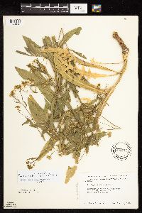 Rorippa austriaca (Crantz) Besser 592017[1134418]Moore, John 266871964-06-04 United States, Minnesota, Pipestone, Below the falls;Pipestone National Monument;106N;46W;01, 44.015848 -96.317669 |
MIN:Plants | 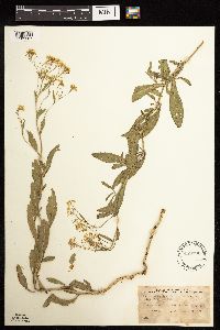 Rorippa austriaca (Crantz) Besser 489991[1183267]Stevens, O. 2341937-06-22 United States, North Dakota, Cass, Hickson, Cass Co, Sec. 7, Twp. 137, R. 44;;137N;44W;07 |
MIN:Plants | Arabis nuttallii (Kuntze) B. L. Robinson 117550[]Burglehaus, F. s.n.1894-05-24 United States, Wyoming, Park, Yellowstone Park...Near Mammoth Hot Springs;Yellowstone National Park;;a, 2134m |
MIN:Plants | Arabis nuttallii (Kuntze) B. L. Robinson 117551[]Burglehaus, F. s.n.1894-06-10 United States, Wyoming, Park, Yellowstone Park...Near Mammoth Hot Springs;Yellowstone National Park;;a, 2134m |
MIN:Plants | Braya humilis (C.A. Meyer) B.L. Robinson 417226[]Spetzman, L. 41211950-07-17 United States, Alaska, Arctic North Slope...Noatak & Kugururok R.;Noatak National Preserve;;;, 67.9666667 -161.9166667, 152m |
MIN:Plants | Boechera lemmonii (S. Watson) W.A. Weber 233272[]Congdon, J. s.n.1898-08-10 United States, California, Tuolumne, Mt. Dana, Tuolumne County;Yosemite National Park;;;, 37.8999 -119.2211 |
MIN:Plants | Boechera lemmonii (S. Watson) W.A. Weber 607909[]Seim, A. s.n.1946-07-13 United States, Wyoming, Park, Mt. Washburn, Yellowstone National Park;Yellowstone National Park |
MIN:Plants | Boechera lemmonii (S. Watson) W.A. Weber 529339[]Gillett, G. 2621953-07-03 United States, California, Tehama, Lassen Volcanic National Park...near Diamond Peak...Tehama County;Lassen Volcanic National Park, 2225m |
MIN:Plants | Boechera lemmonii (S. Watson) W.A. Weber 233274[]Congdon, J. s.n.1898-08-25 United States, California, Tuolumne, Mt. Warren, Tuolumne County;Yosemite National Park |
MIN:Plants | Camelina sativa (L.) Crantz 117980[]Burglehaus, F. s.n.1893-07-00 United States, Wyoming, Park, Near Mammoth Hot Springs;Yellowstone National Park;;;, 44.96694 -110.71139, 1890m |
MIN:Plants | Camelina sativa (L.) Crantz 117975[]Nelson, Aven; et al. 59561899-07-18 United States, Wyoming, Park, Yellowstone National Park...Undine Falls;Yellowstone National Park |
MIN:Plants | Camelina sativa (L.) Crantz 117989[]Taylor, B. T11761891-08-00 United States, Minnesota, Pope, Glenwood;;N;;, 45.65 -95.365833 |
MIN:Plants | 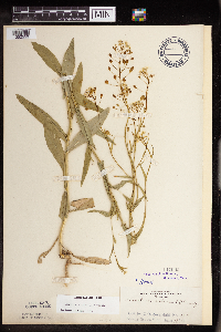 Camelina sativa (L.) Crantz 117990[1352559]Rosendahl, C. 5531902-06-19 United States, Minnesota, Houston, Spring Grove;;101N;07W;, 43.543923 -91.6707 |
MIN:Plants | 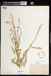 Camelina sativa (L.) Crantz 117991[1352560]Sheldon, Edmund S7531891-07-00 United States, Minnesota, Brown, Sleepy Eye;;110N;32W;, 44.325885 -94.684758 |
MIN:Plants |  Camelina sativa (L.) Crantz 117992[1352561]Sheldon, Edmund s.n.1895-06-00 United States, Minnesota, Ramsey, Poplar Island Lake. Ramsey Co.;;;;, 45.080032 -93.166927 |
MIN:Plants | Camelina sativa (L.) Crantz 117996[]Sandberg, John s.n.1890-06-00 United States, Minnesota, Hennepin, [no further data];;;;, 45 -93.47 |
MIN:Plants | Camelina sativa (L.) Crantz 551997[]Nelson, H. s.n.1958-07-00 United States, North Dakota, Cass, Fargo. |
MIN:Plants | Camelina sativa (L.) Crantz 952426[1292224]Kramer, Leona s.n.1927-00-00 United States, Minnesota, Mower, [no further data], 43.67147 -92.752514 |
MIN:Plants | Draba lemmonii S. Watson 234151[]Congdon, J. s.n.1895-08-27 United States, California, Tuolumne, Mt. Dana, Tuolumne County;Yosemite National Park;;;, 37.8999 -119.2211 |
MIN:Plants | Draba lemmonii S. Watson 234154[]Congdon, J. s.n.1898-08-10 United States, California, Tuolumne, Mt. Dana, Tuolumne County;Yosemite National Park;;;, 37.8999 -119.2211 |
MIN:Plants | Draba lemmonii S. Watson 234152[]Congdon, J. s.n.1895-08-27 United States, California, Tuolumne, Mt. Dana, Tuolumne County;Yosemite National Park;;;, 37.8999 -119.2211 |
MIN:Plants | Draba stenoloba Ledebour 118907[]Nelson, Aven; et al. 55111899-06-23 United States, Wyoming, Park, Yellowstone National Park...Madison River;Yellowstone National Park;;;, 44.66475 -110.98251 |
MIN:Plants | Draba stenoloba Ledebour 234379[]Congdon, J. s.n.1894-08-15 United States, California, Tuolumne, Corral, Soda Springs, Tuolumne County;Yosemite National Park |
MIN:Plants | Draba stenoloba Ledebour 523037[]Cooper, William s.n.1906-08-13 United States, Colorado, Larimer, Long's Pk;Rocky Mountain National Park, 91m |
MIN:Plants | Draba stenoloba Ledebour 700244[]Glaser, Paul 5501974-06-10 United States, Alaska, Thorofare Bluffs. NE1/4SW1/4 of section;Denali National Park;017S;14W;18, 1433m |
MIN:Plants |  Cardamine flexuosa Withering 899126[1352593]Schimpf, D. DJS4322007-06-08 United States, Minnesota, Hennepin, Hennepin County, Plymouth. T118N R22W near center sec 32.;;118N;22W;32, 44.9858333 -93.49 |
MIN:Plants |  Cardamine flexuosa Withering 926669[1352592]Schimpf, D. DJS6122011-06-09 United States, Minnesota, Hennepin, Minneapolis. Just N of N entrance, Willey Hall, University of Minnesota.;;29N;24W;25, 44.9734722 -93.2440278 |
MIN:Plants |  Cardamine flexuosa Withering 950614[1290063]Schimpf, David J. DJS8562016-07-04 United States, Minnesota, Saint Louis, T50N R14W NW1/4 Sec12; Univerity of Minnesota Duluth campus, Swenson Science Building, 46.816528 -92.087917 |
MIN:Plants | Lepidium montanum Nuttall 576726[]Erdman, J. 781959-06-25 United States, Colorado, Montezuma, Montezuma Co.: Mesa Verde National Park. Wetherill Mesa;Mesa Verde National Park;;;, 37.24454 -108.46527, 2438m |
MIN:Plants | Boechera platysperma (A. Gray) Al-Shehbaz 234472[]Congdon, J. s.n.1889-08-21 United States, California, Mariposa, Chilnualna Creek above Falls, Mariposa County;Yosemite National Park |
MIN:Plants | Boechera platysperma (A. Gray) Al-Shehbaz 529448[]Gillett, G. 3121952-08-06 United States, California, Shasta, Lassen Volcanic National Park...summit area of Lassen Peak...Shasta County;Lassen Volcanic National Park, 2804m |
MIN:Plants | Boechera platysperma (A. Gray) Al-Shehbaz 233321[]Congdon, J. s.n.1885-07-01 United States, California, Mariposa, Glacier Point, Yosemite, Mariposa County;Yosemite National Park |
MIN:Plants | Erysimum inconspicuum (S. Watson) MacMillan 118166[]Manning, Sara s.n.1884-06-12 United States, Wisconsin, Pierce, Maiden Rock |
MIN:Plants | Erysimum inconspicuum (S. Watson) MacMillan 385176[]Thatcher, E. 551945-08-15 United States, South Dakota, Lawrence, Opposite Lead Country Club; 3 miles N.E. of Hanna, Lawrence County |
MIN:Plants | Erysimum inconspicuum (S. Watson) MacMillan 119421[]Nelson, Aven; et al. 58751899-07-15 United States, Wyoming, Park, Yellowstone National Park...Soda Butte;Yellowstone National Park |
MIN:Plants | Erysimum inconspicuum (S. Watson) MacMillan 119427[]Sandberg, John s.n.1885-07-00 United States, Minnesota, Goodhue, Vasa;;N;;, 44.499832 -92.730926 |
MIN:Plants | Erysimum inconspicuum (S. Watson) MacMillan 119428[]Sheldon, Edmund S3611891-06-00 United States, Minnesota, Blue Earth, Madison Lake;;N;;, 44.239469 -93.828345 |
MIN:Plants | Erysimum inconspicuum (S. Watson) MacMillan 119429[]Sheldon, Edmund S72191893-09-00 United States, Minnesota, Big Stone, Graceville;;N;;, 45.56913 -96.434506 |
MIN:Plants | Erysimum inconspicuum (S. Watson) MacMillan 119430[]Sheldon, Edmund s.n.1895-06-00 United States, Minnesota, Hennepin, Minneapolis;;N;;, 44.979965 -93.263836 |
MIN:Plants | Erysimum inconspicuum (S. Watson) MacMillan 119431[]Sandberg, John s.n.1885-07-00 United States, Minnesota, Goodhue, Red Wing;;113N;14W;, 44.555216 -92.495543 |
MIN:Plants | Erysimum inconspicuum (S. Watson) MacMillan 119432[]Menzel, Max s.n.1895-07-00 United States, Minnesota, Pipestone, Pipestone [assuming the quarry area; town generally noted as Pipestone City by collector];Pipestone National Monument;106N;46W;01, 44.01585 -96.31767 |
MIN:Plants | Erysimum inconspicuum (S. Watson) MacMillan 119433[]Upham, Warren s.n.1884-00-00 United States, Minnesota, Hennepin, Minneapolis;;N;;, 44.979965 -93.263836 |
MIN:Plants | Erysimum inconspicuum (S. Watson) MacMillan 119471[]Moyer, Lycurgus 17851903-06-27 United States, Minnesota, Big Stone, Ortonville;;N;;, 45.304687 -96.444779 |
MIN:Plants | Erysimum inconspicuum (S. Watson) MacMillan 119472[]Sheldon, Edmund S38011892-08-00 United States, Minnesota, Otter Tail, Pelican Lake;;N;;, 46.699403 -96.02061 |
MIN:Plants | Erysimum inconspicuum (S. Watson) MacMillan 119473[]Moyer, Lycurgus s.n.1903-06-27 United States, Minnesota, Big Stone, Ortonville;;N;;, 45.304687 -96.444779 |
MIN:Plants | Erysimum inconspicuum (S. Watson) MacMillan 119475[]Aiton, G. s.n.1891-06-00 United States, Minnesota, Hennepin, Collected near Minneapolis;;N;;, 44.979965 -93.263836 |
MIN:Plants | Erysimum inconspicuum (S. Watson) MacMillan 119476[]Sandberg, John s.n.1889-06-00 United States, Minnesota, Hennepin, [no further data];;;;, 45 -93.47 |
MIN:Plants | Erysimum inconspicuum (S. Watson) MacMillan 119477[]Sheldon, Edmund s.n.1895-06-00 United States, Minnesota, Ramsey, Poplar Island Lake [possibly Island Lake in Shoreview];;030N;23W;, 45.080032 -93.166927 |
MIN:Plants | Erysimum inconspicuum (S. Watson) MacMillan 119478[]Aiton, G. s.n.1891-05-00 United States, Minnesota, Hennepin, Collected near Minneapolis;;N;;, 44.979965 -93.263836 |
MIN:Plants | Erysimum inconspicuum (S. Watson) MacMillan 119479[]Sheldon, Edmund s.n.1895-06-00 United States, Minnesota, Hennepin, Minneapolis;;N;;, 44.979965 -93.263836 |
MIN:Plants | Erysimum inconspicuum (S. Watson) MacMillan 264098[]Holzinger, John s.n.1901-08-00 United States, Minnesota, Hennepin, Near Minneapolis;;N;;, 44.979965 -93.263836 |
MIN:Plants | Erysimum inconspicuum (S. Watson) MacMillan 264099[]Holzinger, John s.n.1896-08-00 United States, Minnesota, Hennepin, Minneapolis;;N;;, 44.979965 -93.263836 |
MIN:Plants | Erysimum inconspicuum (S. Watson) MacMillan 276115[]Moyle, J. 1881938-07-05 United States, Minnesota, Clearwater, Itasca Park, La Salle Springs; NW1/4 NE1/4 T143N R37W;Itasca State Park;143N;37W;7, 47.216478 -95.413899 |
MIN:Plants | Erysimum inconspicuum (S. Watson) MacMillan 337029[]Lakela, Olga 14301936-06-20 United States, Minnesota, Saint Louis, Yard of cottage, Bayside, Duluth; Sec. 18;;N;;18, 46.76699 -92.0965 |
MIN:Plants | Erysimum inconspicuum (S. Watson) MacMillan 348433[]Nielsen, E. 20641933-07-02 United States, Minnesota, Hubbard, La Salle Springs, Itasca State Park;Itasca State Park;143N;35W;, 47.195787 -95.107789 |
MIN:Plants | Erysimum inconspicuum (S. Watson) MacMillan 353842[]Lakela, Olga 25521938-07-09 United States, Minnesota, Saint Louis, Cliff W of Haines Road at Skyline Parkway, Duluth;;N;;, 46.75948 -92.16508 |
MIN:Plants | Erysimum inconspicuum (S. Watson) MacMillan 370184[]Moore, John; et al. 142401941-06-13 United States, Minnesota, Norman, Beside hwy 75, 5.5 mi NE of Hendrum, Norman Co.;;;;, 47.320683 -96.72851 |
MIN:Plants | Erysimum inconspicuum (S. Watson) MacMillan 371022[]Moore, John 130651940-06-20 United States, Minnesota, Yellow Medicine, S side of Granite Falls;;N;;, 44.809958 -95.545575 |
MIN:Plants | Erysimum inconspicuum (S. Watson) MacMillan 372463[]Moore, John; et al. 145651941-06-15 United States, Minnesota, Polk, Beside hwy 2 and 59, 1 mi E of Erskine, Polk Co.;;;;, 47.66746 -95.988544 |
MIN:Plants | Erysimum inconspicuum (S. Watson) MacMillan 381243[]Moore, John 155201942-06-27 United States, Minnesota, Clay, Campbell Beach, 6.5 mi W of Hawley;;N;;, 46.880711 -96.454397 |
MIN:Plants | Erysimum inconspicuum (S. Watson) MacMillan 381682[]Moore, John 155661942-06-28 United States, Minnesota, Polk, 4.5 mi W of Fertile on Beltrami Road;;N;;, 47.536036 -96.376814 |
MIN:Plants | Erysimum inconspicuum (S. Watson) MacMillan 391772[]Lakela, Olga 60271945-07-08 United States, Minnesota, Saint Louis, Minnesota Point, Duluth; Sec. 19;Minnesota Point;049N;13W;19, 46.741215 -92.062388 |
MIN:Plants | Erysimum inconspicuum (S. Watson) MacMillan 407626[]Lakela, Olga 83311949-06-20 United States, Minnesota, Saint Louis, Along rr right-a-way at Armstrong Lake;;N;;, 47.844609 -92.115349 |
MIN:Plants | Erysimum inconspicuum (S. Watson) MacMillan 412782[]Moore, John; Moore, Marjorie 107581939-06-25 United States, Minnesota, Dakota, 1/4 mi W of Fifth Avenue and just S of Church Street, South St. Paul;;028N;22W;, 44.905226 -93.045075 |
MIN:Plants | Erysimum inconspicuum (S. Watson) MacMillan 412913[]Moore, John; Moore, Marjorie 114131939-08-03 United States, Minnesota, Roseau, Along the rr right-of-way N of the Longworth School;;N;;, 48.982491 -95.364961 |
MIN:Plants | Erysimum inconspicuum (S. Watson) MacMillan 421202[]Lakela, Olga 107181950-07-16 United States, Minnesota, Saint Louis, Below Skyline Parkway, 60th Ave. West, Duluth;;N;;, 46.73983 -92.17332 |
MIN:Plants | Erysimum inconspicuum (S. Watson) MacMillan 427734[]Jones, George Neville 180351946-07-05 United States, Minnesota, Saint Louis, Armstrong Lake, near Ely, along rr;;N;;, 47.844609 -92.115349 |
MIN:Plants | Erysimum inconspicuum (S. Watson) MacMillan 437384[]Moore, John; Moore, Marjorie 122491939-08-30 United States, Minnesota, Roseau, 1 mi W of Pelan;;N;;, 48.643586 -96.415266 |
MIN:Plants | Erysimum inconspicuum (S. Watson) MacMillan 444716[]Moore, John; Huff, N. 180601945-07-27 United States, Minnesota, Morrison, 1 mi SE of Little Falls;;N;;, 45.966116 -94.34777 |
MIN:Plants |  Erysimum inconspicuum (S. Watson) MacMillan 473800[1356011]Myhre, K. 23731992-06-22 United States, Minnesota, Cass, Located 1 mile west of the Gull River; between the railroad tracks and highway 210. NE1/4 of NW1/4 of section;;133N;29W;18, 46.33322 -94.38002 |
MIN:Plants | Erysimum inconspicuum (S. Watson) MacMillan 501148[]Moore, John 203731949-06-29 United States, Minnesota, Roseau, 1 mi E of Greenbush;;N;;, 48.70053 -96.159754 |
MIN:Plants | Erysimum inconspicuum (S. Watson) MacMillan 526157[]Moore, John 210321951-06-25 United States, Minnesota, Todd, 1.5 mi SE of Staples;;N;;, 46.340161 -94.769991 |
Google Map
Google Maps is a web mapping service provided by Google that features a map that users can pan (by dragging the mouse) and zoom (by using the mouse wheel). Collection points are displayed as colored markers that when clicked on, displays the full information for that collection. When multiple species are queried (separated by semi-colons), different colored markers denote each individual species.