University of Minnesota
http://www.umn.edu/
612-625-5000
http://www.umn.edu/
612-625-5000
Minnesota Biodiversity Atlas
Bell Museum
Dataset: MIN-Plants
Taxa: Equisetaceae
Search Criteria: excluding cultivated/captive occurrences
Bell Museum plants | |
 MIN:Plants | 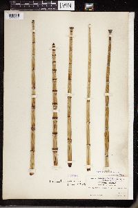 Equisetum hyemale subsp. affine (Engelmann) Calder & Roy L. Taylor 354948[1336244]Macoun, John 1905-06-20 Canada, British Columbia, Selkirk, Howser Lake, 50.383333 -116.95, 610m |
MIN:Plants | 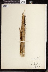 Equisetum hyemale subsp. affine (Engelmann) Calder & Roy L. Taylor 54730[1336245]Demetrio, C.H. 1901-08-00 United States, Missouri, East Leavenworth |
MIN:Plants | 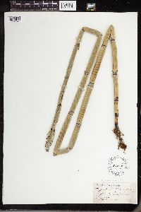 Equisetum hyemale subsp. affine (Engelmann) Calder & Roy L. Taylor 54848[1336246]McDonald, F.E. 1895-06-00 United States, Illinois, Peoria |
MIN:Plants | 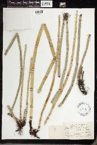 Equisetum hyemale subsp. affine (Engelmann) Calder & Roy L. Taylor 260805[1336247]Lunell, J. 1907-08-18 United States, North Dakota, Rolette, Foothills of the Turtle Mts. near Dunseith |
MIN:Plants |  Equisetum hyemale subsp. affine (Engelmann) Calder & Roy L. Taylor 766079[1336248]McDonald, F.E. 1895-06-00 United States, Illinois, Peoria |
MIN:Plants |  Equisetum hyemale subsp. affine (Engelmann) Calder & Roy L. Taylor 456108[1336249]Ownbey, Gerald B. 1937-09-14 United States, Wyoming, Albany, E of the summit, Laramie Mts. Laramie t Cheyenne highway. |
MIN:Plants |  Equisetum hyemale subsp. affine (Engelmann) Calder & Roy L. Taylor 463871[1336250]Abbott, Robinson S. 1961-08-31 United States, South Dakota, Grant, just W of Milbank |
MIN:Plants |  Equisetum hyemale subsp. affine (Engelmann) Calder & Roy L. Taylor 463874[1336251]Abbott, Robinson S. 1950-05-06 United States, Connecticut, Litchfield, Canaan |
MIN:Plants |  Equisetum hyemale subsp. affine (Engelmann) Calder & Roy L. Taylor 565712[1336252]Pollard, Henry M. 1954-07-15 United States, California, Santa barbara, at mouth of Carpenteria Creek |
MIN:Plants |  Equisetum hyemale subsp. affine (Engelmann) Calder & Roy L. Taylor 354949[1336253]Petersen, H. 1904-07-09 Canada, British Columbia, Selkirk, brook above Carbonate, 975m |
MIN:Plants |  Equisetum hyemale subsp. affine (Engelmann) Calder & Roy L. Taylor 303550[1336254]Durand, E.J. United States, New York, Tompkins, Ithaca |
MIN:Plants |  Equisetum hyemale subsp. affine (Engelmann) Calder & Roy L. Taylor 54754[1336255]Rusby, Henry H. 4161881-07-00 United States, New Mexico and Arizona, 34.326031 -108.90332 |
MIN:Plants |  Equisetum hyemale subsp. affine (Engelmann) Calder & Roy L. Taylor 568364[1336256]Abbott, Robinson S. 1961-08-31 United States, South Dakota, Grant, just W of Millbank |
MIN:Plants |  Equisetum hyemale subsp. affine (Engelmann) Calder & Roy L. Taylor 240185[1336257]Congdon, J.W. 1885-06-00 United States, California, Mariposa, Footman Mt |
MIN:Plants |  Equisetum hyemale subsp. affine (Engelmann) Calder & Roy L. Taylor 594818[1336258]Baldwin, W.K.W. 1961-07-24 Canada, Ontario, Thunder Bay District, Allan Water River. McKewen Lake near railway bridge |
MIN:Plants |  Equisetum hyemale subsp. affine (Engelmann) Calder & Roy L. Taylor 54656[1336259]Suksdorf, Wilhelm N. 1904-09-15 United States, Washington, Klickitat, Columbia River, Bingen |
MIN:Plants |  Equisetum hyemale subsp. affine (Engelmann) Calder & Roy L. Taylor 54666[1336260]Suksdorf, W.N. 1892-08-00 United States, Washington, Klickitat, Columbia River |
MIN:Plants |  Equisetum hyemale subsp. affine (Engelmann) Calder & Roy L. Taylor 54654[1336261]Suksdorf, W.N. 1892-08-04 United States, Washington, Klickitat, Columbia River |
MIN:Plants |  Equisetum hyemale subsp. affine (Engelmann) Calder & Roy L. Taylor 961041[1336114]Hill, A.J. 1900-03-00 Canada, British Columbia, Sunbury |
MIN:Plants | Equisetum hyemale subsp. affine (Engelmann) Calder & Roy L. Taylor []Timothy J. S. Whitfeld 37312023-07-18 United States, Minnesota, Washington, Crystal Spring Scientific and Natural Area; 0.4 miles northeast of the intersection of Scandia Trail North and Hwy 95, 45.257137 -92.764558, 261m |
MIN:Plants |  Equisetum hyemale subsp. affine (Engelmann) Calder & Roy L. Taylor 974499[1396863]Smith, Welby R WRS361632019-05-29 United States, Minnesota, Ramsey, Along the Rice Creek North Regional Trail in Shoreview. In a somewhat ruderal grassy habitat along a small stream (tributary to Rice Creek). Habitat not prone to flooding., 45.0998 -93.18012 |
MIN:Plants |  Equisetum hyemale subsp. affine (Engelmann) Calder & Roy L. Taylor 974288[1396652]Smith, Welby R WRS362342019-07-02 United States, Minnesota, Dakota, Spring Lake Regional Park. About 10.3 km (6.4 miles) west of the Mississippi River Bridge in Hastings at a heading of 278 degrees., 44.75748 -92.97986 |
MIN:Plants |  Equisetum hyemale subsp. affine (Engelmann) Calder & Roy L. Taylor 974337[1396701]Smith, Welby R WRS363512019-07-10 United States, Minnesota, Roseau, Along the side of a township road heading north (380 meters) from Highway 11, about 12.7 km (7.9 miles) W-SW of the approximate center of Greenbush at a heading of 250 degrees., 48.65954 -96.34397 |
MIN:Plants |  Equisetum hyemale subsp. affine (Engelmann) Calder & Roy L. Taylor 974361[1396725]Smith, Welby R WRS363532019-07-10 United States, Minnesota, Roseau, In a small scrap of species-poor aspen woods adjacent to the north side of Highway 11, about 2.7 km (1.7 miles) S-SW of the approximate center of Badger., 48.761169 -96.032794 |
MIN:Plants |  Equisetum hyemale subsp. affine (Engelmann) Calder & Roy L. Taylor 974519[1396883]Smith, Welby R WRS363612019-07-08 United States, Minnesota, Roseau, Hayes Lake State Park, about 35 km (22.8 miles) SW of the approximate center of Warroad at a heading of 212 degrees., 48.63512 -95.56284 |
MIN:Plants | 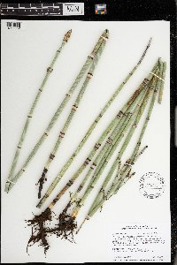 Equisetum hyemale subsp. affine (Engelmann) Calder & Roy L. Taylor 974518[1396882]Smith, Welby R WRS363652019-07-16 United States, Minnesota, McLeod, "The Forty" State Wildlife Management Area, about 12.2 km (7.6 miles) southwest of the approximate center of Winsted at 202 degrees., 44.86002 -94.10764 |
MIN:Plants | 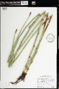 Equisetum hyemale subsp. affine (Engelmann) Calder & Roy L. Taylor 974515[1396879]Smith, Welby R WRS363792019-07-16 United States, Minnesota, McLeod, Phasianus Waterfowl Production Area. Just SE of the junction of 140th street and Nature Avenue, about 2 km (1.3 miles) SW of Biscay., 44.81573 -94.29491 |
MIN:Plants | Equisetum hyemale subsp. affine (Engelmann) Calder & Roy L. Taylor []Timothy J. S. Whitfeld 367022023-07-07 United States, Minnesota, Marshall, Huntley Management Area, 0.5 miles northwest of right angle turn of 130th Avenue NE, 48.45447 -96.19626, 354m |
MIN:Plants | 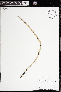 Equisetum hyemale subsp. affine (Engelmann) Calder & Roy L. Taylor 974236[1397426]Dunevitz, Hannah L. 5511991-07-30 United States, Minnesota, Winona, About one mile north of Fillmore County line., 43.86 -91.77 |
MIN:Plants |  Equisetum hyemale subsp. affine (Engelmann) Calder & Roy L. Taylor 977488[1401074]Anderson, Derek S. 37902021-10-29 United States, Minnesota, Carlton, Sawyer WMA. About 3 km south of Sawyer. Off Cty. Rd. 7, about 3.5 km south of its intersection with State Hwy. 210. Near the carry-in access to pool/pond., 46.64442 -92.6364 |
MIN:Plants |  Equisetum hyemale subsp. affine (Engelmann) Calder & Roy L. Taylor 977261[1402845]Lee, Michael MDL64072013-09-04 United States, Minnesota, Crow Wing, Lower Hay Lake Public Water Access. Gently rolling sand plain four miles north of Pequot Lakes, seven miles southeast of Pine River.On the south shore of Lower Hay Lake (Upper Whitefish reservoir)., 46.66022699 -94.28552306, 378m |
MIN:Plants |  Equisetum hyemale subsp. affine (Engelmann) Calder & Roy L. Taylor 977426[1401011]Lee, Michael MDL62862013-07-03 United States, Minnesota, Fillmore, Rugged forested terrain along the lower reaches of Shattuck Creek, one mile west of Choice, nine miles southeast of Lanesboro., 43.66029644 -91.81589343, 283m |
MIN:Plants | 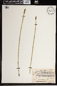 Equisetum kansanum J.H. Schaffn. 967801[1368361]Drew, L.A. s.n.1971-06-20 United States, Minnesota, Clay, 3.5 miles E Glyndon; T139N R46W sec. 16 SE NE 1/4, 46.85699 -96.486867 |
MIN:Plants |  Equisetum fontinale Copel. 278857[1000931]Copeland, E.B. 4031930-06-24 United States, California, Butte, 1500m |
MIN:Plants |  Equisetum hyemale var. intermedium A.A. Eaton 54725[1000933]Dodge, C.K. 681896-06-11 United States, Michigan, Saint Clair, Near Port Huron |
MIN:Plants |  Equisetum hyemale var. pumilum A.A. Eaton 54728[1000934]Eaton, A.A. 701896-08-00 United States, New Hampshire, Rockingham, North Hampton |
MIN:Plants |  Equisetum hyemale var. suksdorfii A.A. Eaton 54734[1000935]Suksdorf, W.N. 711902-09-00 United States, Washington, Klickitat, Bingen |
MIN:Plants |  54906[1000936]Small, J.K. s.n.1889-05-30 United States, Pennsylvania, Lancaster, Vicinity of Penryn |
MIN:Plants |  Equisetum variegatum var. nelsoni A.A. Eaton 55000[1000937]Nelson, N.L.T. 851901-06-00 United States, Illinois, Cook, East Chicago, 41.850033 -87.650052 |
MIN:Plants |  Equisetum hyemale var. affine A.A. Eaton 54723[1000932]Eaton, A.A. 721902-07-00 United States, New Hampshire, Rockingham, Seabrook |
MIN:Plants |  Equisetum hyemale subsp. affine (Engelmann) Calder & Roy L. Taylor 977460[1401046]Lee, Michael MDL65552014-07-10 United States, Minnesota, Fillmore, Along the middle reaches of Diamond Creek, in rugged terrain five miles east of Lanesboro, not far up the north fork of the creek from its confluence with the south fork., 43.7231012733 -91.86858834391, 262m |
MIN:Plants |  Equisetum hyemale var. affine (Engelm.) A.A. Eaton 948207[1292402]Smith, Welby R. WRS308142007-09-06 United States, Minnesota, Saint Louis, About 3 miles SE of Chisholm. Near the south levee of an iron ore tailings basin.; T058N R20W sec35, 47.4575 -92.8366667 |
MIN:Plants |  Equisetum hyemale var. affine (Engelm.) A.A. Eaton 948220[1292389]Smith, Welby R. WRS308282007-09-14 United States, Minnesota, Wabasha, Along the Zumbro River, about 2.5 miles southwest of Dumfries.; T110N R11W sec20, 44.3135275 -92.1528847 |
MIN:Plants |  Equisetum hyemale var. affine (Engelm.) A.A. Eaton 947821[1291891]Smith, Welby R. 304422007-07-27 United States, Minnesota, Marshall, Thief Lake State Wildlife Management Area. SE of SE of section; T158N R43W sec35, 48.4588705 -96.1497468 |
MIN:Plants |  Equisetum hyemale var. affine (Engelm.) A.A. Eaton 947865[1292000]Smith, Welby R. 304872007-08-02 United States, Minnesota, Cass, Chippewa National Forest, about 5 miles N-NW of Remer. SW of NE of section; T142N R26W sec10, 47.1317422 -93.9511369 |
MIN:Plants |  Equisetum hyemale var. affine (Engelm.) A.A. Eaton 947896[1292031]Smith, Welby R. 305182007-08-08 United States, Minnesota, Ramsey, Poplar Lake County Park in Shoreview. SE of NE of section; T030N R23W sec01, 45.119131 -93.1105064 |
MIN:Plants |  Equisetum hyemale var. affine (Engelm.) A.A. Eaton 947937[1291943]Smith, Welby R. 305642007-08-14 United States, Minnesota, Pine, About 1.5 miles south of Duxbury, in St. Croix State Forest. SW of NW of section; T042N R17W sec21, 46.1087647 -92.5047931 |
MIN:Plants |  Equisetum hyemale var. affine (Engelm.) A.A. Eaton 955249[1296545]Friesner, Ray C. 97551936-07-25 United States, Indiana, Morgan |
MIN:Plants |  Equisetum hyemale var. affine (Engelm.) A.A. Eaton 971017[1394486]Smith, Welby R WRS359792018-06-23 United States, Minnesota, Olmsted, Gordon W. Yeager Wildlife Management Area. On the east side of Rochester about 0.8 km (0.5 mile) N-NE of the intersection of Highways 22 and 9 at a heading of 115 degrees., 44.0282333 -92.4168167 |
MIN:Plants |  Equisetum hyemale var. affine (Engelm.) A.A. Eaton 974654[1396984]Smith, Welby R WRS364492019-08-13 United States, Minnesota, Wright, Collinwood Regional Park, about 6 km (3.7 miles) southwest of the approximate center of Cokato at a heading of 233 degrees., 45.04593 -94.25033 |
MIN:Plants |  Equisetum hyemale var. affine (Engelm.) A.A. Eaton 974510[1396874]Smith, Welby R WRS365082019-08-30 United States, Minnesota, Pine, Chengwatana State Forest, about 14.5 km (9 miles) due east of the approximate center of Pine city., 45.82522 -92.78319 |
MIN:Plants | Equisetum hyemale var. affine (Engelm.) A.A. Eaton []Timothy J. S. Whitfeld 37202023-07-07 United States, Minnesota, Marshall, Huntley Management Area, 0.5 miles northwest of right angle turn of 130th Avenue NE, 48.45447 -96.19626, 354m |
MIN:Plants |  Equisetum hyemale var. affine (Engelm.) A.A. Eaton 976042[1373595]Smith, Welby R WRS367422020-07-01 United States, Minnesota, Washington, Collected in a steep forested ravine along Brown's Creek Trail on the north side of Stillwater., 45.07554 -92.81649 |
MIN:Plants |  Equisetum x mildeanum Rothm. 947929[1291935]Smith, Welby R. 305552007-08-14 United States, Minnesota, Pine, About 16 miles east of Askov on Highway 32. NW of NW of section; T043N R17W sec25, 46.1832005 -92.4423753 |
MIN:Plants |  Equisetum telmateia subsp. braunii (Milde) Hauke 564941[1336749]Cotter, Shirley 1952-03-22 United States, California, Marin, near San Rafael |
MIN:Plants |  Equisetum telmateia subsp. braunii (Milde) Hauke 635488[1336750]Taylor, John 8077A1971-05-30 United States, California, Mendocino, along the Gualala River, on the N side 1 mile from its mouth at the Pacific Ocean |
MIN:Plants |  Equisetum telmateia subsp. braunii (Milde) Hauke 674673[1336751]Abair, Christopher 1976-04-00 United States, Washington, Olympia, Saint Martin's College campus |
MIN:Plants |  Equisetum telmateia subsp. braunii (Milde) Hauke 54956[1336752]Allen, O.D. 1895-05-01 United States, Washington, Cascade Mountains, Upper Valley of the Nesqually |
MIN:Plants |  Equisetum telmateia subsp. braunii (Milde) Hauke 54742[1336753]Elmer, A.D.E. 1903-05-00 United States, California, San mateo, San Brofio Hills |
MIN:Plants |  Equisetum telmateia subsp. braunii (Milde) Hauke 240222[1336754]Congdon, J.W. 1880-04-30 United States, California, Sonoma, Santa Rosa Road |
MIN:Plants |  Equisetum telmateia subsp. braunii (Milde) Hauke 357552[1336755]Muensher, W.C. 1939-04-26 United States, Washington, Whatcom, Birch Bay |
MIN:Plants |  Equisetum telmateia subsp. braunii (Milde) Hauke 356872[1336758]Daby, M.S. 1906-08-00 Canada, British Columbia, near Port Renfrew, Vancouver. Osland |
MIN:Plants |  Equisetum telmateia subsp. braunii (Milde) Hauke 240178[1336759]Congdon, J.W. 1880-03-02 United States, California, Sonoma, Santa Rosa Road |
MIN:Plants |  Equisetum telmateia subsp. braunii (Milde) Hauke 54961[1336760]Zeller, Dr. S.M. 9721917-06-25 United States, Washington, San Juan Islands, Friday Harbor |
MIN:Plants |  Equisetum telmateia subsp. braunii (Milde) Hauke 54955[1336761]Elmer, A.D.E. 1903-04-00 United States, California, San mateo, Portola |
MIN:Plants |  Equisetum telmateia subsp. braunii (Milde) Hauke 260824[1336762]Grant, Geo. B. 1904-04-00 United States, California, Pasadena |
MIN:Plants |  Equisetum telmateia subsp. braunii (Milde) Hauke 54963[1336763]Hill, A.J. 1900-11-01 Canada, British Columbia, New Westminster |
MIN:Plants |  Equisetum telmateia subsp. braunii (Milde) Hauke 605753[1336764]Scoggan, H.J. 1964-07-02 Canada, British Columbia, Nanaimo and vicinity, Vancouver Island. |
MIN:Plants |  Equisetum telmateia subsp. braunii (Milde) Hauke 608509[1336765]Joley, D. 1967-08-15 United States, California, Plumas, Deer Creek |
MIN:Plants |  Equisetum telmateia subsp. braunii (Milde) Hauke 260829[1336766]Parish, S.B. 1907-03-09 United States, California, San bernardino, San Bernadino Valley |
MIN:Plants |  Equisetum telmateia subsp. braunii (Milde) Hauke 260825[1336767]Lunell, J. 1903-06-15 United States, Oregon, Portland |
MIN:Plants |  Equisetum telmateia subsp. braunii (Milde) Hauke 54958[1336768]Suksdorf, W.N. 1893-04-29 United States, Washington, Klickitat, near Bingen |
MIN:Plants |  Equisetum telmateia subsp. braunii (Milde) Hauke 601037[1336769]Munns, C.E. 1966-04-09 United States, Washington, Lewis, Chehalis |
MIN:Plants |  Equisetum telmateia subsp. braunii (Milde) Hauke 54957[1336770]Moyer, Lycurgus R. United States, Washington, Puget Sound, Vashon Island |
MIN:Plants |  Equisetum telmateia subsp. braunii (Milde) Hauke 240095[1336771]Congdon, J.W. 1880-08-02 United States, California, Sonoma, Santa Rosa Road |
MIN:Plants |  Equisetum telmateia subsp. braunii (Milde) Hauke 558745[1336772]Pringle, C.G. 1881-10-12 United States, Oregon, Cascades of the Columbia |
MIN:Plants |  Equisetum telmateia subsp. braunii (Milde) Hauke 576230[1336773]Cotter, Shirley 1952-05-04 United States, California, Sonoma, W of Skaggs Springs |
MIN:Plants |  Equisetum telmateia subsp. braunii (Milde) Hauke 54965[1336774]Hill, A.J. Canada, British Columbia, New Westminster |
MIN:Plants | 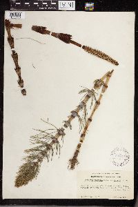 Equisetum telmateia subsp. braunii (Milde) Hauke 360135[1336775]Parks, H.E. 241211938-04-10 United States, California, Del norte, Darlingtonia, Smith River, 107 - 122m |
MIN:Plants | 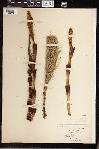 Equisetum telmateia subsp. braunii (Milde) Hauke 54964[1336776]Hill, A.J. Canada, British Columbia, New Westminster |
MIN:Plants | 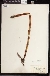 Equisetum telmateia subsp. braunii (Milde) Hauke 54960[1336777]Elmer, A.D.E. 1902-03-00 United States, California, San mateo, King's Mountain |
MIN:Plants | 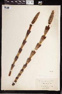 Equisetum telmateia subsp. braunii (Milde) Hauke 54962[1336778]Hill, A.J. 1900-04-25 Canada, British Columbia, New Westminster |
MIN:Plants | 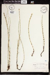 Equisetum littorale Kuhl. 441106[1336401]Abbott, Robinson S. 1962-07-15 United States, Pennsylvania, Northumberland, behind Bucknedl View Trailer Court, Montandon. |
MIN:Plants | 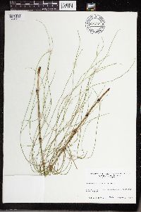 Equisetum littorale Kuhl. 690268[1336402]Ahles, H.E. 1977-08-19 United States, Massachusetts, Hampshire, end of Huntington Road at Connecticut River, Hadley |
MIN:Plants | 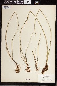 Equisetum littorale Kuhl. 260786[1336403]Fernald, M.L. 1893-07-07 United States, Maine, Aroostook, Fort Fairfield |
MIN:Plants | 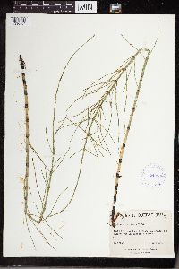 Equisetum littorale Kuhl. 424998[1336404]Marie-Victorin 1941-06-30 Canada, Quebec, Chambly, Longueuil |
MIN:Plants |  Equisetum littorale Kuhl. 54767[1336405]Fernald, M.L. 1893-07-07 United States, Maine, Aroostook, Fort Fairfield |
MIN:Plants |  Equisetum littorale Kuhl. 388174[1336406]Eaton, A.A. 1896-06-00 United States, Massachusetts, Borders of Merrimac River, Amsbury |
MIN:Plants |  Equisetum littorale Kuhl. 486881[1336407]Deane, Walter 1885-08-17 United States, Vermont, Lake Champlain, Knights Island |
MIN:Plants |  Equisetum littorale Kuhl. 583110[1336408]Hunnewell, F.W. 1920-06-13 United States, New Hampshire, Grafton, Lebanon, Connecticut River |
MIN:Plants |  Equisetum littorale Kuhl. 54779[1336409]Eaton, A.A. 1897-06-30 United States, Massachusetts, Newburyport |
MIN:Plants |  Equisetum littorale Kuhl. 260793[1336410]Knight, O.W. 1906-07-19 United States, Maine, Penobscot River, Veazie |
MIN:Plants |  Equisetum littorale Kuhl. 260783[1336411]Knight, O.W. 1906-10-06 United States, Maine, Penobscot River, Veazie |
MIN:Plants |  Equisetum littorale Kuhl. 54776[1336412]Eaton, A.A. 1902-06-00 United States, Massachusetts, Amesbury |
MIN:Plants |  Equisetum littorale Kuhl. 54772[1336413]Eaton, A.A. 1900-08-00 United States, Massachusetts, Amesbury |
MIN:Plants |  Equisetum littorale Kuhl. 563575[1336414]Bennett, H.R. 1958-07-28 United States, Michigan, Keweenaw, near shore of Lake Superior, Eagle River |
MIN:Plants |  Equisetum littorale Kuhl. 54775[1336415]Eaton, A.A. 1896-05-30 United States, Massachusetts, Amesbury |
MIN:Plants |  Equisetum littorale Kuhl. 54771[1336416]Eaton, A.A. 1901-06-02 United States, Massachusetts, Newburyport |
MIN:Plants |  Equisetum littorale Kuhl. 260784[1336417]Knight, O.W. 1905-08-12 United States, Maine, St. John River, Fort Kent |
MIN:Plants |  Equisetum littorale Kuhl. 54774[1336418]Eaton, A.A. 1896-05-30 United States, Massachusetts, Amesbury |
Google Map
Google Maps is a web mapping service provided by Google that features a map that users can pan (by dragging the mouse) and zoom (by using the mouse wheel). Collection points are displayed as colored markers that when clicked on, displays the full information for that collection. When multiple species are queried (separated by semi-colons), different colored markers denote each individual species.