University of Minnesota
http://www.umn.edu/
612-625-5000
http://www.umn.edu/
612-625-5000
Minnesota Biodiversity Atlas
Bell Museum
Dataset: MIN-Plants
Taxa: Brassicaceae
Search Criteria: excluding cultivated/captive occurrences
Bell Museum plants | |
 MIN:Plants | Draba borealis de Candolle 530000[]Hardy, Robert s.n.1945-07-22 United States, Alaska, Aleutian Islands ... Attu Island ... Sarana Bay;Aleutian Islands Wilderness;;;, 52.877732 -173.26241 |
MIN:Plants | Draba borealis de Candolle 382575[]Morse, Marius s.n.1944-07-17 United States, Alaska, Aleutian Islands ... Adak Island;Aleutian Islands Wilderness;;;, 51.88 -176.65806 |
MIN:Plants | Draba borealis de Candolle 530498[]Hardy, Robert 1251945-07-22 United States, Alaska, Aleutian Islands ... Attu Island ... Sarana Bay;Aleutian Islands Wilderness;;;, 52.877732 -173.26241 |
MIN:Plants | 403579[]Spetzman, L. 11141948-08-12 United States, Alaska, Arctic North Slope...Sadlerochit River;Arctic National Wildlife Refuge;;;, 69.5833333 -144.75, 457m |
MIN:Plants | 484316[]Juhnke, C. 376 CMJ FRO1999-06-22 United States, Minnesota, Goodhue, Frontenac State Park Goodhue County ... Near Sand Point trail beach ... T112N R13W NE NW NE 13;Frontenac State Park;112N;13W;13, 44.505359 -92.319092 |
MIN:Plants | 912520[]Lee, Michael MDL44852007-08-01 United States, Minnesota, Wadena, Wadena County ... Along the Leaf River at the U.S. Highway 71 bridge (<1/4-mile upstream from the mouth of Union Creek), three miles northeast of downtown Wadena ... T135N R35W SW1/4 of NW1/4 of SW1/4 Sec.27 ... UTM: 5148997N 339342E. 135N 35W 27, 46.477747 -95.082628 |
MIN:Plants | 913089[]Smith, Welby 229911993-07-20 United States, Minnesota, Sibley, Sibley County... At the southeast end of Washington Lake, about 8 miles northeast of Arlington... T114N R26W SE1/4 of NE1/4 of Sec 22.. 114N 26W 22, 44.6669444 -93.9336111 |
MIN:Plants | 699728[]Ziegler, S.; et al. 17261975-07-14 United States, Wisconsin, Vernon, Vernon Co.; Island 10; Mississippi River-mile #689.2; T14N R7W Sec 7...Large island E side of main channel;Upper Mississippi National Wildlife Refuge;014N;07W;07, 193m |
MIN:Plants | 919336[]Cholewa, A. 27512010-06-24 United States, Minnesota, Pine, Snake River boat access on St. Croix River (just downstream of Snake River).;Chengwatana State Forest;039N;20W;31, 45.824435 -92.88825 |
MIN:Plants | 461873[]Kaul, R.; et al. 64681989-06-23 United States, Minnesota, Hubbard, Hubbard Co.; near Rose Lake, just west of US 71.;;142N;35W;21, 47.101752 -95.119703 |
MIN:Plants | 499019[]Juhnke, C. 444 CMJ FRO1999-07-13 United States, Minnesota, Goodhue, Frontenac State Park Goodhue County ..Near railroad tracks south of Hwy. 61 ... T112N R13W SW SW NE 14;Frontenac State Park;112N;13W;14, 44.505485 -92.339405 |
MIN:Plants | 477039[]Wheeler, Gerald 170251997-08-08 United States, Minnesota, Swift, Swift County ... Ca. 6 mi. NNE of Benson; NW shore of Lake Hassel, at public water access ... NE1/4 NW1/4 Sec. 9 T122N R39W (Benson 9). 122N 39W 9, 45.39048 -95.571817 |
MIN:Plants | 119308[]Menzel, Max 5291896-07-00 United States, Minnesota, Pipestone, Pipestone [assuming the quarry area; town generally noted as Pipestone City by collector];Pipestone National Monument;106N;46W;01, 44.01585 -96.31767 |
MIN:Plants | 119317[]Manning, Sara s.n.1883-08-15 United States, Minnesota, Wabasha, Lake City;;N;;, 44.44402 -92.273367 |
MIN:Plants | 119318[]Moyer, Lycurgus s.n.1894-05-00 United States, Minnesota, Chippewa, Cedar Lake, Montevideo.;;117N;40W;, 44.934626 -95.675774 |
MIN:Plants | 119319[]Moyer, Lycurgus s.n.1894-05-00 United States, Minnesota, Chippewa, Cedar Lake. Chippewa Co.;;117n;40W;, 44.934626 -95.675774 |
MIN:Plants | 119320[]Ballard, C. B7541891-07-00 United States, Minnesota, Carver, Waconia;;116N;25W;, 44.8476 -93.827753 |
MIN:Plants | 119321[]Moyer, Lycurgus s.n. United States, Minnesota, Chippewa, Montevideo;;117N;40W;, 44.934626 -95.675774 |
MIN:Plants | 119322[]G. & L. 17831885-00-00 United States, Minnesota, Chippewa, Montevideo;;117N;40W;, 44.934626 -95.675774 |
MIN:Plants | 119323[]Sheldon, Edmund S10921891-07-00 United States, Minnesota, Brown, Springfield;;N;;, 44.238848 -94.975823 |
MIN:Plants | 119324[]Sheldon, Edmund S5591891-06-00 United States, Minnesota, Waseca, Waseca;;N;;, 44.077741 -93.507443 |
MIN:Plants | 119325[]Sheldon, Edmund S14031891-08-00 United States, Minnesota, Lincoln, Lake Benton;;109N;45W;, 44.24108 -96.26172 |
MIN:Plants | 119326[]MacMillan, C.; et al. 1971900-08-00 United States, Minnesota, Polk, Crookston;;150N;146W;30, 47.782001 -96.600066 |
MIN:Plants | 119327[]Ballard, C. 27751900-08-00 United States, Minnesota, Marshall, Warren;;N;;, 48.196642 -96.77284 |
MIN:Plants | 119328[]Taylor, B. T4121891-06-00 United States, Minnesota, Waseca, Buffalo Lake;;N;;, 44.057215 -93.721838 |
MIN:Plants | 119329[]Aiton, G. s.n.1890-07-00 United States, Minnesota, Hennepin, Wayside, city [Minneapolis];;N;;, 44.979965 -93.263836 |
MIN:Plants | 119330[]Taylor, B. T10061891-08-00 United States, Minnesota, Pope, Glenwood;;N;;, 45.65 -95.365833 |
MIN:Plants | 119331[]Sheldon, Edmund S37491892-08-00 United States, Minnesota, Otter Tail, Lake Lida;;N;;, 46.580385 -95.968507 |
MIN:Plants | 119332[]Taylor, B. T9021891-07-00 United States, Minnesota, Pope, Glenwood;;N;;, 45.65 -95.365833 |
MIN:Plants | 119333[]Ballard, C. B1101891-06-00 United States, Minnesota, Scott, Shakopee;;N;;, 44.798019 -93.526899 |
MIN:Plants | 119334[]Aiton, G. s.n.1891-08-00 United States, Minnesota, Hennepin, Collected near Minneapolis;;N;;, 44.979965 -93.263836 |
MIN:Plants | 119335[]Holzinger, John s.n.1889-07-05 United States, Minnesota, Winona, Stockton, Winona Co.;;N;;, 44.027463 -91.769873 |
MIN:Plants | 119336[]Ballard, C. B2841891-06-00 United States, Minnesota, Scott, Jordan, Scott Co.;;114N;23W;, 44.674435 -93.582701 |
MIN:Plants | 119337[]Holzinger, John s.n.1886-06-00 United States, Minnesota, Winona, Winona;;N;;, 44.049963 -91.639315 |
MIN:Plants | 119338[]Kassube, J. s.n.1878-06-00 United States, Minnesota, Hennepin, Minneapolis;;N;;, 44.979965 -93.263836 |
MIN:Plants | 119339[]Herrick, C. 69-51876-07-00 United States, Minnesota, Hennepin, Minneapolis;;N;;, 44.979965 -93.263836 |
MIN:Plants | 119340[]Sandberg, John s.n.1890-08-00 United States, Minnesota, Hennepin, [no further data];;;;, 45 -93.47 |
MIN:Plants | 119341[]Holzinger, John s.n.1886-06-00 United States, Minnesota, Winona, Mississippi valley, Winona Co.;;N;;, 43.873038 -91.336459 |
MIN:Plants | 119342[]Sandberg, John s.n.1881-07-00 United States, Minnesota, Goodhue, Cannon Falls;;N;;, 44.49989 -92.85476 |
MIN:Plants | 119343[]Herrick, C. s.n.1878-06-00 United States, Minnesota, Hennepin, Minneapolis;;N;;, 44.979965 -93.263836 |
MIN:Plants | 119344[]Ballard, C. 26161900-08-00 United States, Minnesota, Kittson, Humboldt;;163N;50W;, 48.93381 -97.128306 |
MIN:Plants | 119345[]Taylor, B. T6311891-07-00 United States, Minnesota, Faribault, Minnesota Lake;;N;;, 43.804422 -93.827689 |
MIN:Plants | 119346[]Sheldon, Edmund S8831891-07-00 United States, Minnesota, Brown, Sleepy Eye;;N;;, 44.297183 -94.72415 |
MIN:Plants | 119347[]Sheldon, Edmund S29591892-07-00 United States, Minnesota, Mille Lacs, Milaca;;037N;27W;, 45.692047 -93.698793 |
MIN:Plants | 119349[]Skinner, S. 1941902-07-23 United States, Minnesota, Jackson, Banks of Des Moines River, Heron Lake Region;;N;;, 43.753411 -95.199284 |
MIN:Plants | 119350[]Taylor, B. T3571891-07-00 United States, Minnesota, Pope, Glenwood;;N;;, 45.65 -95.365833 |
MIN:Plants | 119351[]Aiton, G. 17831902-06-21 United States, Minnesota, Olmsted, Rochester;;106N;14W;00, 43.97834 -92.498342 |
MIN:Plants | 119352[]Ballard, C. B10011892-07-00 United States, Minnesota, Nicollet, Swan Lake, Nicollet Co.;;;;, 44.307345 -94.256516 |
MIN:Plants | 119353[]Frost, W. F2761892-07-00 United States, Minnesota, Kandiyohi, Willmar;;N;;, 45.121908 -95.043342 |
MIN:Plants | 119354[]Sheldon, Edmund S33601892-08-00 United States, Minnesota, Otter Tail, Battle Lake;;133N;;, 46.32559 -95.717658 |
MIN:Plants | 119355[]Sheldon, Edmund s.n.1895-06-00 United States, Minnesota, Hennepin, Fort Snelling;Fort Snelling Military Reservation;028N;23W;, 44.905162 -93.166462 |
MIN:Plants | 119356[]Sheldon, Edmund S38781892-08-00 United States, Minnesota, Otter Tail, Dalton;;N;;, 46.173849 -95.915609 |
MIN:Plants | 119357[]Sheldon, Edmund S38511892-08-00 United States, Minnesota, Otter Tail, Dalton;;N;;, 46.173849 -95.915609 |
MIN:Plants | 119358[]Taylor, B. T4141891-06-00 United States, Minnesota, Waseca, Janesville;;N;;, 44.116078 -93.708004 |
MIN:Plants | 119359[]Sheldon, Edmund S73411892-09-00 United States, Minnesota, Traverse, Wheaton;;N;;, 45.804405 -96.499233 |
MIN:Plants | 119360[]Sheldon, Edmund s.n.1895-06-00 United States, Minnesota, Hennepin, Ft. Snelling;Fort Snelling Military Reservation;028N;23W;, 44.905162 -93.166462 |
MIN:Plants | 119361[]MacMillan, C.; et al. 51900-08-00 United States, Minnesota, Polk, Crookston;;150N;46W;30, 47.782 -96.60007 |
MIN:Plants | 119362[]Menzel, Max s.n.1895-06-00 United States, Minnesota, Pipestone, Pipestone [assuming the quarry area; town generally noted as Pipestone City by collector];Pipestone National Monument;106N;46W;01, 44.01585 -96.31767 |
MIN:Plants | 119363[]Campbell, Jennie s.n.1895-07-00 United States, Minnesota, Stearns, Waite Park;;124N;28W;, 45.541667 -94.205126 |
MIN:Plants | 119364[]Lyon, H. s.n.1899-07-12 United States, Minnesota, Houston, Crooked Creek, Houston Co.;Dorer Memorial Hardwood State Forest;N;;, 43.604456 -91.373075 |
MIN:Plants | 119365[]Butters, F.; et al. 35141918-06-21 United States, Minnesota, Wabasha, Zumbro Valley near Keegan;;;;, 44.383856 -92.032945 |
MIN:Plants | 119416[]Moyer, Lycurgus s.n.1894-06-00 United States, Minnesota, Chippewa, Cedar Lake, Montevideo.;;117N;40W;, 44.934626 -95.675774 |
MIN:Plants | 229749[]Rosendahl, C.; Butters, F. 29151915-06-19 United States, Minnesota, Olmsted, Along roadside, 5 mi W of Rochester;;N;;, 44.021586 -92.57061 |
MIN:Plants | 263912[]Holzinger, John s.n.1901-06-00 United States, Minnesota, Winona, Winona Co.;;N;;, 43.926613 -91.67387 |
MIN:Plants | 267171[]Anonymous 871912-07-31 United States, Minnesota, Kandiyohi, Willmar;;N;;, 45.121908 -95.043342 |
MIN:Plants | 276116[]Moyle, J. 521930-06-24 United States, Minnesota, Clearwater, Itasca Park. Campus. SW1/4 SE1/4 Sec. 2, T143N, R36W.;Itasca State Park;143N;36W;2, 47.231973 -95.201528 |
MIN:Plants | 276119[]Grant, Martin 30271929-08-06 United States, Minnesota, Clearwater, Itasca Park. Campus. SW1/4 SW1/4 Sec/ 2, T143N, R36W.;Itasca State Park;143N;36W;2, 47.231973 -95.201528 |
MIN:Plants | 291901[]Fryklund, P. s.n.1925-07-05 United States, Minnesota, Roseau, [no further data];;;;, 48.791028 -95.795207 |
MIN:Plants | 304243[]Lakela, Olga 13061935-09-15 United States, Minnesota, Saint Louis, Above Congdon Creek, near Vermilion Road, Duluth.;;N;;, 46.82243 -92.06891 |
MIN:Plants | 337033[]Lakela, Olga 17631936-08-19 United States, Minnesota, Saint Louis, Bayside, Sec. 19, Duluth. [other collections indicates this is in T49N R13W, Minnesota Point];Minnesota Point;049N;13W;19, 46.78333 -92.10639 |
MIN:Plants | 353432[]Moyle, J. 13921934-07-14 United States, Minnesota, Hubbard, Near Badoura;;N;;, 46.862181 -94.766121 |
MIN:Plants | 353718[]Moyle, J. 14671934-07-12 United States, Minnesota, Becker, Itasca Park. Near Twin Island Lake. SW1/4 SW1/4 Sec. 5, T142N, R36W.;Itasca State Park;143N;36W;5, 47.144933 -95.265368 |
MIN:Plants | 358354[]Stork, H. 10831925-06-00 United States, Minnesota, Itasca, Bowstring;Chippewa National Forest;;;, 47.54306 -93.79639 |
MIN:Plants | 364195[]Moyer, Lycurgus s.n.1897-07-25 United States, Minnesota, Chippewa, Montevideo;;117N;40W;, 44.934626 -95.675774 |
MIN:Plants | 364813[]Gilbert, H.; et al. 1541923-06-07 United States, Minnesota, Saint Louis, Duluth;;;;, 46.78333 -92.10639 |
MIN:Plants | 376063[]Dahl, A. s.n.1935-08-23 United States, Minnesota, Kandiyohi, Shores of Norway Lake;;N;;, 45.320377 -95.121252 |
MIN:Plants | 381737[]Moore, John; et al. 153061942-06-18 United States, Minnesota, Hennepin, S shore of Independence Lake. Hennepin Co.;;;;, 45.0294 -93.64875 |
MIN:Plants | 383232[]Moore, John 158341943-06-24 United States, Minnesota, Washington, Washington Co.; Ravine, 2 mi N of Stillwater on hwy 95;;030N;20W;, 45.084979 -92.817348 |
MIN:Plants | 383682[]Moore, John 160011943-08-24 United States, Minnesota, Fillmore, 2 mi. up the Root River from Peterson.;Dorer Memorial Hardwood State Forest;N;;, 43.7858 -91.83231 |
MIN:Plants | 385993[]Lakela, Olga 56661944-08-09 United States, Minnesota, Lake, Near Fisherman's dock, East Beaver Bay.;North Shore;055N;08W;00, 47.250316 -91.359973 |
MIN:Plants | 411998[]Moore, John; Moore, Marjorie 111711939-07-27 United States, Minnesota, Lake of the Woods, Along the W side of Harrison River, Northwest Angle;Northwest Angle;N;;, 49.37179 -95.1483 |
MIN:Plants | 412356[]Moore, John; Moore, Marjorie 116001939-08-09 United States, Minnesota, Kittson, Creek bank; W line of Sec. 3 Richardville Twp.;;N;;3, 48.941389 -96.875278 |
MIN:Plants | 427423[]Darveaux, B. s.n.1991-06-24 United States, Minnesota, Washington, Forest Lake, Anoka Co. [Washington Co.] Left side of exit ramp 129 off of highway 35.;;032N;21W;7, 45.275653 -93.009258 |
MIN:Plants | 430096[]Smith, Welby 206351992-06-30 United States, Minnesota, Rice, About 6.5 miles north-northeast of Faribault. NE1/4 of NE1/4 of Sec.;Cannon River Wilderness Park;110N;20W;4, 44.3708344 -93.223053 |
MIN:Plants | 440251[]Smith, Welby 158101989-07-18 United States, Minnesota, Freeborn, Freeborn Co. At the S end of Geneva Lake, about 3 mi NE of Clarks Grove; NE1/4 NE1/4 sec.30, T104N R20W;;104N;20W;30, 43.7852783 -93.269722 |
MIN:Plants | 442097[]Moore, John; Huff, N. 186841946-06-19 United States, Minnesota, Rock, Mound Springs State Park.;Blue Mounds State Park;103N;45W;, 43.717857 -96.232381 |
MIN:Plants | 442917[]Lakela, Olga 131451951-07-13 United States, Minnesota, Saint Louis, Hotel grounds at Kettle Falls, Rainy Lake.;Voyageurs National Park;070N;18W;, 48.521444 -92.665357 |
MIN:Plants | 443891[]Husveth, J. 96-1681996-06-28 United States, Minnesota, Wabasha, Wabasha Co. T110N R12W SW1/4 of the SE1/4 of S27; Zumbro River;Dorer Memorial Hardwood State Forest;110N;12W;27, 44.302288 -92.23979 |
MIN:Plants | 444481[]Nation, R. 94-4261994-07-18 United States, Minnesota, Mower, Lake Louise State Park. Mower Co.; Tract 1B. T101N R14W W1/2 SE1/4 of Sec. 21;Lake Louise State Park;101N;14W;21, 43.536578 -92.519043 |
MIN:Plants | 444721[]Moore, John; Huff, N. 180481945-07-26 United States, Minnesota, Morrison, 1 mi. N of Little Falls;;N;;, 45.990833 -94.362502 |
MIN:Plants | 445133[]Moore, John; et al. 176491945-07-09 United States, Minnesota, Cottonwood, Red Rock Dells, 6 mi S of Sanborn;;;;, 44.123013 -95.102214 |
MIN:Plants | 447209[]Schik, K. 95-2521995-08-01 United States, Minnesota, Kittson, Kittson Co. T161N R50W SW1/4 of the SE1/4 of S20; Red River;;161N;50W;20, 48.755868 -97.151799 |
MIN:Plants | 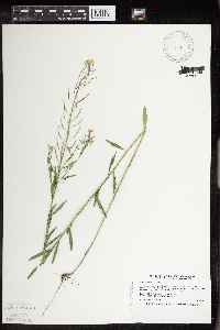 456727[1352996]Smith, Welby 210771992-07-23 United States, Minnesota, Le Sueur, Le Sueur Co.; about 1 mi E of Elysian, on the N side of Highway 60. In abandoned gravel pit; Le Sueur Co.; about 1 mi E of Elysian, on the N side of Highway 60. In abandoned gravel pit; T109N R23W SW1/4 of SW1/4 of Sec 31. 109N 23W 31, 44.1983337 -93.6436081 |
MIN:Plants | 457205[]Smith, Welby 154411989-06-25 United States, Minnesota, Freeborn, Myre Big Island State Park. Freeborn County...Helmer Myre State Park, about 2 miles southeast of Albert Lea. On 'Big Island' in Albert Lea Lake; SW1/4 NW1/4 sec.19, T 102N R 20W. 102N 20W 19, 43.625 -93.2875 |
MIN:Plants | 459491[]Smith, Welby 163381989-08-31 United States, Minnesota, Chisago, Wild River State Park. Chisago County...St. Croix Wild River State Park, about 7 mi NE of North Branch; on the St. Croix River...SW1/4 NE1/4 sec.32, T36N R20W. 036N 20W 32, 45.5666656 -92.8616638 |
MIN:Plants | 462808[]Lakela, Olga 157311952-09-17 United States, Minnesota, Saint Louis, Above Hoist Bay of Basswood Lake, QSWRC.;Boundary Waters Canoe Area Wilderness / Superior National Forest;064N;10W;9, 47.8833 -92.0167 |
MIN:Plants | 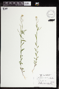 473760[1352994]Myhre, K. 27981992-07-22 United States, Minnesota, Cass, Cass Co.; Plants located on Ottertail Peninsula in Leech Lake; T 144N R 29W NW1/4 of NE1/4 of Sec 30;Chippewa National Forest / Leech Lake Indian Reservation;144N;29W;30, 47.25962 -94.399224 |
MIN:Plants | 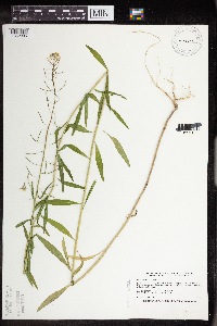 473817[1352995]Smith, Welby 209181992-07-15 United States, Minnesota, Marshall, Marshall Co.; In Old Mill State Park, about 11 miles east of Argyle. T 156N R 46W NW1/4 of SE1/4 of Sec 4.;Old Mill State Park;156N;46W;4, 48.3602791 -96.5702744 |
MIN:Plants | 475846[]Smith, Welby 211341992-07-28 United States, Minnesota, Fillmore, Dorer Memorial Hardwood State Forest. Fillmore County...In the Root River Valley, about 0.5 mile south of Peterson (about 3/8 mile west of mile post 23 on the Root River Trail). Gravel pit...T 104N R 8W SW1/4 of SE1/4 of Sec 30. 104N 08W 30, 43.7791667 -91.8386111 |
MIN:Plants | 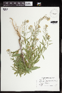 476387[1352999]Smith, Welby 196791991-07-18 United States, Minnesota, Roseau, Roseau Co.; In Warroad, boat landing on Lake of the Woods (Muskeg Bay); T 163N R 36W SE1/4 of SW1/4 of Sec 28;;163N;36W;28, 48.9055557 -95.3016663 |
Google Map
Google Maps is a web mapping service provided by Google that features a map that users can pan (by dragging the mouse) and zoom (by using the mouse wheel). Collection points are displayed as colored markers that when clicked on, displays the full information for that collection. When multiple species are queried (separated by semi-colons), different colored markers denote each individual species.