University of Minnesota
http://www.umn.edu/
612-625-5000
http://www.umn.edu/
612-625-5000
Minnesota Biodiversity Atlas
Bell Museum
Dataset: MIN-Plants
Taxa: Brassicaceae
Search Criteria: excluding cultivated/captive occurrences
Bell Museum plants | |
 MIN:Plants | 501143[]Moore, John 203611949-06-29 United States, Minnesota, Roseau, Along the bank of the South Fork of Two Rivers, 1 mi E of Greenbush;;N;;, 48.70053 -96.159754 |
MIN:Plants | 508410[]Smith, Welby 170111990-06-25 United States, Minnesota, Steele, Aurora Wildlife Management Area. Steele Co. Aurora State Wildlife Management Area. On the W side of U.S. Trunk Hwy 218, about 9 mi SE of Owatonna; Steele Co. Aurora State Wildlife Management Area. On the W side of U.S. Trunk Hwy 218, about 9 mi SE of Owatonna; T106N R19W NE1/4 of NW1/4 of Sec 28. 106N 19W 28, 43.9627762 -93.1175003 |
MIN:Plants | 508414[]Smith, Welby 170661990-06-27 United States, Minnesota, Martin, Martin Co. Bright Lake County Park, about 2.5 mi NE of Ceylon; T101N R31W SW1/4 of NE1/4 of Sec 17;;101N;31W;17, 43.5533333 -94.7047195 |
MIN:Plants |  518690[1353000]Darveaux, B. s.n.1991-07-30 United States, Minnesota, Steele, Owatonna, Steele Co. Rt 14 heading east off of Hwy 35, near 176 mile marker on left side of road.;;107N;20W;, 44.066112 -93.226071 |
MIN:Plants |  519351[1356001]Scott, P. 10311997-08-16 United States, Minnesota, Cook, Cook Co.; near Coast Guard Station at Grand Marais T61NR1E sec 21.;North Shore / Superior National Forest;061N;01E;21, 47.754721 -90.330669 |
MIN:Plants | 519702[]Smith, Welby 189681991-06-25 United States, Minnesota, Todd, Todd Co.; Grey Eagle State Wildlife Management Area, about 3 miles W of Grey Eagle; T127N R33W SW1/4 of SE1/4 of Sec 10;Grey Eagle Wildlife Management Area;127N;33W;10, 45.8191681 -94.815834 |
MIN:Plants | 532944[]Lakela, Olga 187211955-06-20 United States, Minnesota, Saint Louis, Alworth grounds of University of Minnesota, Duluth;;N;;, 46.819016 -92.085425 |
MIN:Plants | 554665[]Moore, John 230021956-09-12 United States, Minnesota, Clay, Clay County...Along the Buffalo River 2 mi NE of Kragnes;;;;, 47.008407 -96.721401 |
MIN:Plants | 558228[]Moore, John 236651957-09-26 United States, Minnesota, Clay, Along the Wild Rice River at Ulen;;N;;, 47.07885 -96.258949 |
MIN:Plants | 568729[]Moore, John 248891959-09-29 United States, Minnesota, Blue Earth, Along the Blue Earth River 1.5 mi S of Mankato;;N;;, 44.14876 -94.032573 |
MIN:Plants | 572875[]Moore, John 254951961-06-27 United States, Minnesota, Kittson, Along the bank of the Red River at St. Vincent;;N;;, 48.968333 -97.226111 |
MIN:Plants | 574597[]Moore, John 247121959-07-29 United States, Minnesota, Kittson, Halma;;N;;, 48.661089 -96.60032 |
MIN:Plants | 578617[]Ownbey, Gerald; Bloom, W. 33801962-08-20 United States, Minnesota, Clearwater, Along W shore line of Lower Red Lake, 4.9 mi S of Red Lake River crossing; T151N R36W SE1/4 Sec. 16;Red Lake Indian Reservation;151N;36W;16, 47.897893 -95.272436 |
MIN:Plants | 578631[]Ownbey, Gerald 33241962-08-16 United States, Minnesota, Clearwater, Itasca State Park, Douglas Lodge, S end of E arm, Lake Itasca, near pier below lodge; T143N R36W NE1/4 Sec. 24;Itasca State Park;143N;36W;24, 47.188748 -95.180071 |
MIN:Plants | 592237[]Westkaemper, Remberta s.n.1965-06-00 United States, Minnesota, Stearns, Stearns Co. St. Joseph, St. Benedict College campus;;124N;29W;, 45.543642 -94.322053 |
MIN:Plants | 594357[]Thorne, Robert 310621962-07-16 United States, Minnesota, Clearwater, Above Lake Itasca, Itasca State Park, NE1/4 Sec. 11, T143N, R36W.;Itasca State Park;143N;36W;11, 47.217521 -95.201495 |
MIN:Plants | 607556[]Westkaemper, Remberta s.n.1965-07-00 United States, Minnesota, Stearns, Stearns Co. St. Joseph;;124N;29W;, 45.543642 -94.322053 |
MIN:Plants | 608108[]Moore, John; Moore, Marjorie 272761968-10-10 United States, Minnesota, Anoka, Along the E shore of Fish Lake, Cedar Creek Natural History Area, Bethel Twp.;Cedar Creek National History Area;034N;23W;, 45.428063 -93.203997 |
MIN:Plants | 616651[]Moore, John; Moore, Marjorie 2411969-07-02 United States, Minnesota, Crow Wing, Crow Wing NHA. E1/2 SE1/4 Sec. 6, Garrison Twp.;Crow Wing Natural Area;044N;28W;6, 46.323097 -93.926287 |
MIN:Plants | 622323[]Westkaemper, Remberta s.n.1967-05-00 United States, Minnesota, Stearns, Stearns Co. SBC [St. Benedict's College] Campus, St. Joseph;;124N;29W;, 45.543642 -94.322053 |
MIN:Plants | 627705[]Ownbey, Gerald 45361972-07-09 United States, Minnesota, Crow Wing, 8.4 mi S of Emily, just off rte 6;;N;;, 46.609466 -93.95803 |
MIN:Plants | 668074[]Hsi, Yu-tseng [Eugene] 11951975-09-21 United States, Minnesota, Lyon, Garvin Co. Park, ca. 15 m. S of Marshall along hwy 59;;N;;, 44.262368 -95.748638 |
MIN:Plants | 670712[]Heitlinger, M. 5971972-06-27 United States, Minnesota, McLeod, Schaefer Prairie, near boundary with unplowed prairie; SE1/4 Sec. 34 T115N R29W;Schaefer Prairie, The Nature Conservancy;115N;29W;34, 44.72505 -94.30491 |
MIN:Plants | 687510[]Wheeler, Gerald; Glaser, Paul 19521977-07-09 United States, Minnesota, Itasca, Chippewa National Forest / Leech Lake Indian Reservation. Itasca Co.; Site 97. NE1/4 NW1/4 Sec. 3, T145N, R26W; ca. 21 mi. WNW of Grand Rapids. On a terrace of the Mississippi Itasca Co.; Site 97. NE1/4 NW1/4 Sec. 3, T145N, R26W; ca. 21 mi. WNW of Grand Rapids. On a terrace of the Mississippi River just S of where Hwy. 2 crosses the river (east bank).. 145N 26W 3, 47.404599 -93.956013 |
MIN:Plants | 687907[]Wheeler, Gerald; Glaser, Paul 23561977-08-01 United States, Minnesota, Itasca, Site 168. NE1/4 NW1/4 Sec. 4, T53N, R24W; ca. 11 mi. SSE of Grand Rapids. On the E bank of the Mississippi River.;;053N;24W;4, 47.104778 -93.393168 |
MIN:Plants | 690021[]Ownbey, Gerald 55741977-06-11 United States, Minnesota, Olmsted, Olmsted Co. Base of cliff, oxbow of North Branch Root River; Pleasant Grove Twp. T105N R13W Sec. 20 SE1/4;Dorer Memorial Hardwood State Forest;105N;13W;20, 43.884292 -92.408371 |
MIN:Plants | 691045[]Sperling, C. 1421976-05-26 United States, Minnesota, Douglas, 4.5 mi E, 2 mi S of Carlos;;N;;, 45.943467 -95.19851 |
MIN:Plants | 691176[]Sperling, C. 2061976-05-30 United States, Minnesota, Douglas, Lake Geneva Bible Camp, W side of Lake Geneva;;N;;, 45.899314 -95.327441 |
MIN:Plants | 695972[]Clemants, Steven 8691977-09-01 United States, Minnesota, Olmsted, Dorer Memorial Hardwood State Forest. Olmsted Co. Simpson's Bluff, 3 mi S of Simpson on co. rd 1, North Branch Root River, at base of cliff; T105N R13W E cent Olmsted Co. Simpson's Bluff, 3 mi S of Simpson on co. rd 1, North Branch Root River, at base of cliff; T105N R13W E center of Sec. 20. 105N 13W 20, 43.884292 -92.408371 |
MIN:Plants | 699724[]Ziegler, S. 3631974-07-29 United States, Minnesota, Houston, Upper Mississippi National Wildlife Refuge. Mississippi River Navigation Pool #8. Island 7. Mississippi River mile #687.9. T103N, R4W, Sec. 36. Island on the W Mississippi River Navigation Pool #8. Island 7. Mississippi River mile #687.9. T103N, R4W, Sec. 36. Island on the W side of the main channel; in a wooded area on the northern end of the island.. 103N 04W 26, 43.6825 -91.272199 |
MIN:Plants | 700889[]Dorio, J. 4291977-07-01 United States, Minnesota, Morrison, Lake Alexander, ca. 7 mi. N of Randall on Co. Rd. 6. Path near lake. T131N, R30W, Sec. 6.;;131N;30W;6, 46.187068 -94.506235 |
MIN:Plants | 701211[]Dorio, J. 1031977-06-03 United States, Minnesota, Benton, Benton Co. Englund Ecotone,ca. 5 mi. E of Rice. T37N, R31W, Sec. 13.;Englund Ecotone, The Nature Conservancy;037N;31W;13, 45.698563 -94.143452 |
MIN:Plants | 717512[]Grimmelbein, G. 921979-07-04 United States, Minnesota, Hubbard, Spearhead Lake Preserve.;Spearhead Lake Preserve (Audubon);145N;34W;, 47.368099 -94.990966 |
MIN:Plants | 721191[]Lustig, K. 8661979-08-09 United States, Minnesota, Sherburne, Clear Lake-Mississippi Scenic and Receational River, SNA: 12 mi. SE of St. Cloud, Sec. 14, 22, 23, T34N, R30W.;Clear Lake Scientific Natural Area;034N;30W;, 45.446339 -94.043783 |
MIN:Plants | 724992[]Smith, Welby 33041980-08-10 United States, Minnesota, Wright, Wright Co.; on the N shore of Buffalo Lake; T120N R26W SW1/4 NE1/4 Sec. 25;;120N;26W;25, 45.172559 -93.899917 |
MIN:Plants | 727714[]Lustig, K. 7141979-07-12 United States, Minnesota, Sherburne, Mississippi River Islands Scientific Natural Area. Sherburne & Wright Cos. ...Mississippi Scenic and Recreational River Islands SNA, Mississippi River Islands between Monticello and Elk River. Sec. 2, 3, 4, T32N, R26, 27W; sec. 7, 9, 18, R121N, R23, 24W. 032N 26W 3, 45.293483 -93.556246 |
MIN:Plants | 727753[]Severson, M. 891979-07-18 United States, Minnesota, Polk, Pankratz Prairie South, 7 mi SE of Crookston; T149N R45W SE1/4 Sec. 17, NE1/4 Sec. 20;Pankratz Memorial Prairie, The Nature Conservancy;149N;45W;, 47.716767 -96.416687 |
MIN:Plants |  729510[1352993]Converse, C. 4571980-07-08 United States, Minnesota, Pine, Pine Co. St. Croix Natural Area, 21 mi E of Hinckley, St. Croix riverbank; NW1/4 SW1/4 Sec. 35 T41N R17W;Saint Croix State Park;041N;17W;35, 45.992812 -92.461383 |
MIN:Plants | 734835[]Petron, T. 2581980-07-14 United States, Minnesota, Clay, Bluestem Prairie Scientific Natural Area. Clay County...Bluestem Prairie: 13 mi. E of Moorhead. NW1/4 NE1/4 Sec. 15, T139N, R46W. On the E bank of the Buffalo River.. 139N 46W 15, 46.854948 -96.473403 |
MIN:Plants | 738536[]Galatowitsch, S. 3391982-06-26 United States, Minnesota, Wabasha, Wabasha County...Weaver Dunes: T109N R9W SE1/4 and E1/2 NE1/4 of Sec 7; NW1/4 and W1/2 NE1/4 of Sec 8;Kellogg-Weaver Dunes Scientific Natural Area / Kellogg-Weaver Dunes, The Nature Conservancy;109N;09W;00, 44.23311 -91.91725 |
MIN:Plants | 763127[]Gilbert, H. 1541923-06-07 United States, Minnesota, Saint Louis, Duluth;;N;;, 46.783273 -92.106579 |
MIN:Plants | 763390[]Lugger, O. 290 United States, Minnesota, Blue Earth, Mankato;;N;;, 44.163578 -93.9994 |
MIN:Plants | 763391[]Lugger, O. s.n. United States, Minnesota, Blue Earth, Mankato;;N;;, 44.163578 -93.9994 |
MIN:Plants | 764622[]Ballard, C. s.n.1892-07-00 United States, Minnesota, Nicollet, Swan Lake, Nicollet Co.;;;;, 44.307345 -94.256516 |
MIN:Plants | 764994[]Lugger, O. 6360 United States, Minnesota, Big Stone, Graceville;;N;;, 45.56913 -96.434506 |
MIN:Plants | 773185[]Boe, J. 2541979-06-18 United States, Minnesota, Lake of the Woods, Near Long Point, along shore of Lake of the Woods, path S of outcrops; T164N R33W NE1/4 Sec. 1;;164N;33W;1, 48.981194 -94.949282 |
MIN:Plants | 773836[]Boe, J. 6981979-07-10 United States, Minnesota, Lake of the Woods, Near Long Point, along shore of Lake of the Woods, roadside near outcrops; T164N R33W SW1/4 Sec. 31;;164N;33W;31, 48.981194 -94.949282 |
MIN:Plants | 782394[]Tenney, M. 4401982-07-19 United States, Minnesota, Winona, Whitewater State Park. Winona Co. T107N R10W Sec. 20 SW1/4 NW1/4 SE1/4;Whitewater State Park;107N;10W;20, 44.056501 -92.049518 |
MIN:Plants | 814643[]Wheeler, Gerald 120041988-09-02 United States, Minnesota, Wilkin, Breckenridge (W side), Welles Memorial Park; NW1/4 Sec. 9 T132N R47W (Breckenridge Twp.);;132N;47W;9, 46.26131 -96.584721 |
MIN:Plants | 831851[]Aiton, G. s.n.1890-08-00 United States, Minnesota, [no further data];;;;, 46 -94 |
MIN:Plants | 835519[]Monson, Paul 39451959-06-30 United States, Minnesota, Hubbard, Hubbard Co. R-34 T-143 S-32. 3 mi S of Lake George P.O.; Schoolcraft R.;;143N;34W;32, 47.159698 -95.014004 |
MIN:Plants |  838466[1352992]Smith, Welby 178581990-08-08 United States, Minnesota, Red Lake, Red Lake County ... At 'Old Crossing Treaty State Wayside Park'. On the N bank of the Red Lake River, about 6 miles W of the town of Red Lake Falls ... T151N R45W SE1/4 of SW1/4 of Sec. 27. 151N 45W 27, 47.8666649 -96.4113922 |
MIN:Plants | 841644[]Smith, Welby 133761987-07-07 United States, Minnesota, Washington, Washington Co. Island in the St. Croix River, abut 2 mi NE of Scandia; SE1/4 SE1/4 sec.7, T32N R19W;;032N;19W;7, 45.2675018 -92.7555542 |
MIN:Plants | 491105[]Capistrant, A. AMC13261998-06-23 United States, Minnesota, Carver, Carver Co, T116N R25W S16;;116N;25W;16, 44.855363 -93.838918 |
MIN:Plants | 119297[]Burglehaus, F. s.n.1894-07-22 United States, Wyoming, Park, Yellowstone Park...near Mammoth Hot Springs;Yellowstone National Park, 2134m |
MIN:Plants | 364755[]Jacobs, D. 391939-07-08 Canada, Ontario, Thunder Bay, Thunder Bay District...Cloud Bay |
MIN:Plants | 385350[]Thatcher, E. 761945-08-15 United States, South Dakota, Lake, Hanna Creek, 1/2 mile west of Hanna, Lawrence County |
MIN:Plants | 459616[]Juhnke, C. 332 CMJ FRO1999-06-09 United States, Minnesota, Goodhue, Frontenac State Park Goodhue County ... Along Cty. Rd. 2 ... At beginning of Sand Point trail T112N R13W SW SE NW 13;Frontenac State Park;112N;13W;13, 44.505359 -92.319092 |
MIN:Plants | 269051[]Fassett, N.; et al. 42361927-08-28 United States, Wisconsin, Pepin, Pepin Co. ...Lake Pepin. Pepin. |
MIN:Plants | 493102[]Smith, Welby 157401989-07-17 United States, Minnesota, Benton, Benlacs Wildlife Management Area. Benton County ... Benlacs State Wildlife Management Area, about 7 miles SE of Foley ... SE1/4 SE1/4 section 12, T36N R 28W. 036N 28W 12, 45.625853 -93.770684 |
MIN:Plants | 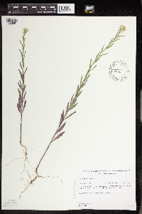 491511[1352991]Gerdes, Lynden 35651999-07-10 United States, Minnesota, Cook, West of active gravel pit; approx. 0.25 mile north of the Gunflint Trail (Cty. 12) & FR 1347 junction; west off FR 1347;Superior National Forest;065N;04W;26, 48.084497 -90.803753 |
MIN:Plants | 573898[]Stevens, O. 24801961-07-09 United States, North Dakota, Cass, Fargo. |
MIN:Plants | 575387[]Garton, C. 91311961-08-01 Canada, Ontario, Rainy River, Rainy River District...Sable I, S. end of Lake of the Woods |
MIN:Plants | 499265[]Juhnke, C. 411 CMJ FRO1999-07-01 United States, Minnesota, Goodhue, Frontenac State Park. Frontenac State Park Goodhue County...Along rairoad tracks south of Hwy. 61 south of the east end of Pleasant Valley Lakelet ... T112N R13W SW SW NE 14. 112N 13W 14, 44.505485 -92.339405 |
MIN:Plants | 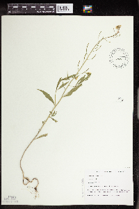 499346[1352998]Capistrant, A. AMC15631998-05-14 United States, Minnesota, Carver, [no further data];;116N;23W;16, 44.855973 -93.592079 |
MIN:Plants | 119315[]Nelson, Aven; et al. 64621899-08-15 United States, Wyoming, Park, Yellowstone National Park...Snake River;Yellowstone National Park |
MIN:Plants | 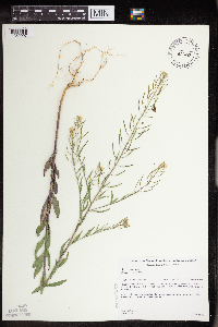 431277[1352997]Gerdes, Lynden 37051999-08-03 United States, Minnesota, Cook, Superior National Forest. T65N R04W S27NWSE. Cook County...Superior National Forest, Gunflint Trail area. Cross River gravel/sand pit ~0.2 mile north of the Gunflint Trail (Cty. 12) and FR 1347 junction. Wet, western edge of west pit.. 065N 04W 27, 48.084242 -90.825443 |
MIN:Plants | 924815[]Chayka, K. KC-11132011-06-28 United States, Minnesota, Ramsey, SE1/4 of NE1/4 of section;Rice Creek Trail County Park;030N;23W;04, 45.1169444 -93.17 |
MIN:Plants | 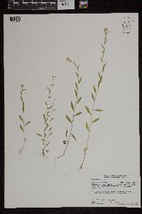 958907[1305144]Lynden B. Gerdes 71232014-07-10 United States, Minnesota, Koochiching, Koochiching State Forest. Approximately 2.82 miles southeast of Ray, MN. South down a forest road that exits Highway 53 ~1.04 miles east of the Highway 53 and Hwy. 217 junction., 48.3875 -93.15305556 |
MIN:Plants |  962952[1346546]Whitfeld, T.J.S. 23162019-06-29 United States, Minnesota, Crow Wing, US Army Corps of Engineers Cross Lake Recreation Area, 46.669661 -94.109854 |
MIN:Plants |  967088[1359781]Rowe, Erika R. ERR5522009-07-25 United States, Minnesota, Beltrami, 0.35 miles west of Kansas City Road; 2 miles southwest of Waskish., 48.13 -94.54 |
MIN:Plants |  979331[1399610]Don Henson 14111982-08-01 United States, Michigan, Delta, Gladstone, E of US-2. T40N R22W, Sec 21, 45.847778 -87.027801 |
MIN:Plants | Draba nivalis Liljeblad 403543[]Spetzman, L. 5951948-07-11 United States, Alaska, Arctic North Slope ... Lake Peters;Arctic National Wildlife Refuge;;;, 69.3333333 -145, 1067m |
MIN:Plants | Draba nivalis Liljeblad 418107[]Spetzman, L. D-21950-07-11 United States, Alaska, Arctic North Slope ... Anaktuvuk Pass;Gates of the Arctic National Park;;;, 68.2833333 -151.4166667, 762m |
MIN:Plants | Draba nivalis Liljeblad 418208[]Spetzman, L. 38081950-07-04 United States, Alaska, Arctic North Slope...Kurupa Lake;Gates of the Arctic National Park;;;, 68.3666667 -154.6666667, 945m |
MIN:Plants | Draba nivalis Liljeblad 418109[]Spetzman, L. 20171949-07-17 United States, Alaska, Arctic North Slope...Kanayut Lake;Gates of the Arctic National Park;;;, 68.3333333 -151, 914m |
MIN:Plants | Draba nivalis Liljeblad 399489[]Spetzman, L. 4331947-08-09 United States, Alaska, Canning River; Syncline Mt. west of Canning Valley.;Arctic National Wildlife Refuge;;;, 69.45 -146.3166667 |
MIN:Plants | Draba nivalis Liljeblad 418054[]Spetzman, L. 17341949-07-07 United States, Alaska, Arctic North Slope ... Anaktuvuk Pass;Gates of the Arctic National Park;;;, 68.2833333 -151.4166667, 914m |
MIN:Plants |  Draba nivalis Liljeblad 954943[1295318]Miller, Maynard M. 1671948-00-00 United States, Alaska, St. Elias Mountains. Mt. Vancouver, site 5-1 |
MIN:Plants |  Draba nivalis Liljeblad 954890[1295371]Baird, Patrick 2701948-00-00 United States, Alaska, St. Elias Mountains. Mt. Vancouver, base camp |
MIN:Plants | Erysimum pallasii (Pursh) Fernald 417998[]Spetzman, L. 20211949-07-17 United States, Alaska, Arctic North Slope...Kanayut Lake;Gates of the Arctic National Park;;;, 68.3333333 -151, 914m |
MIN:Plants | Erysimum pallasii (Pursh) Fernald 403576[]Spetzman, L. 7121948-07-14 United States, Alaska, Arctic North Slope ... Lake Peters;Arctic National Wildlife Refuge;;;, 69.3333333 -145, 1067m |
MIN:Plants | Erysimum pallasii (Pursh) Fernald 399255[]Spetzman, L. 2401947-06-14 United States, Alaska, Shaviovik River, E. Fork;Arctic National Wildlife Refuge;;;, 69.35 -146.7166667 |
MIN:Plants | Erysimum pallasii (Pursh) Fernald 401710[]Spetzman, L. 2671947-06-13 United States, Alaska, Arctic North Slope...Outcrops east of the So. end of the Big Ice field on the Shaviovik R.;Arctic National Wildlife Refuge |
MIN:Plants | Erysimum pallasii (Pursh) Fernald 403577[]Spetzman, L. 9191948-07-30 United States, Alaska, Arctic North Slope...Ikiakpauruk Valley;Arctic National Wildlife Refuge;;;, 69.5 -145.5, 762m |
MIN:Plants | Erysimum pallasii (Pursh) Fernald 700303[]Glaser, Paul 6031974-06-24 United States, Alaska, Mt. McKinley National Park...N1/2Sec.3 T17S R14W, Bergh Lake, Highway Pass;Denali National Park;017S;14W;03, 1067m |
MIN:Plants | Erysimum pallasii (Pursh) Fernald 399249[]Spetzman, L. 2251947-06-09 United States, Alaska, Shaviovik River, E. Fork;Arctic National Wildlife Refuge;;;, 69.4666667 -146.5833333 |
MIN:Plants | Erysimum pallasii (Pursh) Fernald 403578[]Spetzman, L. 11711948-08-17 United States, Alaska, Arctic North Slope...Sadlerochit River;Arctic National Wildlife Refuge;;;, 69.5833333 -144.75, 457m |
MIN:Plants | Descurainia sophia (L.) Webb ex Prantl 914645[]Smith, Welby 225691993-06-22 United States, Minnesota, Stevens, Hornings Pit Wildlife Management Area. Stevens County...Horning's Pit State Wildlife Management Area, about 10 miles west-northwest of Donnelly...T 126N R 44W SW1/4 of NE1/4 of Sec 18. 126N 44W 18, 45.7244444 -96.2433333 |
MIN:Plants | Descurainia sophia (L.) Webb ex Prantl 604304[]Bent, Anne 59042903051959-04-29 United States, New Mexico, San Juan, Chuska Mountains. Toadlena.;Navaho Indian Reservation, 2042m |
MIN:Plants | Descurainia sophia (L.) Webb ex Prantl 392095[]Duncan, W. s.n.1940-06-19 United States, South Dakota, Minnehaha, Sand Hills...Minnehaha Co. |
MIN:Plants | Descurainia sophia (L.) Webb ex Prantl 289013[]Dahl, A. s.n.1932-06-11 United States, Minnesota, Dakota, Railroad bank, S of Station, Nichols [other collections from "Nichols" specify Minnesota River];;027N;23W;18, 44.825884 -93.216999 |
MIN:Plants | Descurainia sophia (L.) Webb ex Prantl 333561[]Dahl, A. s.n.1932-06-11 United States, Minnesota, Dakota, Railroad bank, S of Station, Nichols [Other collections from "Nichols" specify Minnesota River];;027N;23W;18, 44.825884 -93.216999 |
MIN:Plants | Descurainia sophia (L.) Webb ex Prantl 362553[]Rosendahl, C.; Butters, F. 70461938-09-04 United States, Minnesota, Marshall, Shore at W end of Thief Lake;;N;;, 48.49043 -95.891094 |
MIN:Plants | Descurainia sophia (L.) Webb ex Prantl 366918[]Moore, John; Moore, Marjorie 101981938-06-26 United States, Minnesota, Dakota, 1/4 mi W of Fifth Avenue and just S of Church Street, South St. Paul;;028N;22W;, 44.905226 -93.045075 |
MIN:Plants | Descurainia sophia (L.) Webb ex Prantl 421396[]Jacobs, D. 4041947-05-07 United States, Minnesota, Blue Earth, Minneopa Park;;N;;, 44.152457 -94.068583 |
MIN:Plants |  Descurainia sophia (L.) Webb ex Prantl 441855[1352936]Cholewa, A. 25712000-05-20 United States, Minnesota, Ramsey, Ramsey Co. University of Minnesota St. Paul campus, drainage overflow area just east of cow barn. T29N R23W S21.;;029N;23W;21, 44.984523 -93.177092 |
MIN:Plants |  Descurainia sophia (L.) Webb ex Prantl 459200[1352938]Puchalski, L. 2121993-06-18 United States, Minnesota, Polk, Polk Co.; on W side of highway; T150N R40W SE1/4 of NE1/4 of sec 35;;150N;40W;35, 47.768484 -95.740675 |
MIN:Plants | Descurainia sophia (L.) Webb ex Prantl 550607[]Cotter, Shirley 18911951-06-10 United States, Minnesota, Yellow Medicine, Vacant lot W Granite Falls;;N;;, 44.809958 -95.545575 |
MIN:Plants | Descurainia sophia (L.) Webb ex Prantl 554246[]Moore, John 229171956-06-13 United States, Minnesota, Clay, 5 mi E of Felton;;N;;, 47.078525 -96.400174 |
Google Map
Google Maps is a web mapping service provided by Google that features a map that users can pan (by dragging the mouse) and zoom (by using the mouse wheel). Collection points are displayed as colored markers that when clicked on, displays the full information for that collection. When multiple species are queried (separated by semi-colons), different colored markers denote each individual species.