University of Minnesota
http://www.umn.edu/
612-625-5000
http://www.umn.edu/
612-625-5000
Minnesota Biodiversity Atlas
Bell Museum
Dataset: MIN-Plants
Taxa: Brassicaceae
Search Criteria: excluding cultivated/captive occurrences
Bell Museum plants | |
 MIN:Plants | Physaria occidentalis (S. Watson) O'Kane & Al-Shehbaz 499337[]Went, F. s.n.1966-08-00 United States, California, Contra Costa, Berkeley |
MIN:Plants | Noccaea fendleri (A. Nelson) Holub 584601[]Morean, Edith 2631962-08-09 United States, Washington, Olympic National Park; High Divide Trail below Heart Lake;Olympic National Park |
MIN:Plants | Noccaea fendleri (A. Nelson) Holub 121294[]Whitehouse, E. 195851948-04-14 United States, Texas, Brewster, Brewster Co.: Big Bend National Park, along Rio Grande River below Santa Elena Canyon;Big Bend National Park |
MIN:Plants | Noccaea fendleri (A. Nelson) Holub []Romano, M. GW22422003-07-24 United States, Colorado, Gunnison, Kebler Pass Road, 38.916667 -107.4, 2438m |
MIN:Plants | Draba glabella Pursh 539847[]Viereck, Les 15441956-08-00 United States, Alaska, Mt. McKinley Nat. Park...N.S. slope to summit of Mt. Eielson (Copper Mt.);Denali National Park;;;, 63.4166667 -150.3333333, 1676m |
MIN:Plants | Draba glabella Pursh 225544[]Cooper, William 3961909-08-24 United States, Michigan, Keweenaw, Gull Ids, Isle Royale;Isle Royale National Park |
MIN:Plants | Draba glabella Pursh 403475[]Spetzman, L. 11411948-08-12 United States, Alaska, Arctic North Slope...Sadlerochit River;Arctic National Wildlife Refuge;;;, 69.5833333 -144 |
MIN:Plants | Draba glabella Pursh 690119[]Glaser, Paul 5881974-06-24 United States, Alaska, Mt. McKinley National Park...N1/2Sec.3 T17S R14W, Bergh Lake, Highway Pass;Denali National Park;017S;14W;03, 1067m |
MIN:Plants | Draba glabella Pursh 690120[]Glaser, Paul 6271974-06-30 United States, Alaska, Mt. McKinley National Park; Highway Pass. SE1/4 NW1/4 of section;Denali National Park;017S;13W;01, 1189m |
MIN:Plants | Draba glabella Pursh 418209[]Spetzman, L. 38061950-07-04 United States, Alaska, Arctic North Slope...Kurupa Lake;Gates of the Arctic National Park;;;, 68.3666667 -154.6666667, 945m |
MIN:Plants | Draba glabella Pursh 403542[]Spetzman, L. 7501948-07-17 United States, Alaska, Arctic North Slope ... Lake Schrader;Arctic National Wildlife Refuge;;;, 69.4166667 -145, 914m |
MIN:Plants | 539994[]Tester, John s.n.1957-07-11 United States, Minnesota, Mahnomen, 3-4 miles W and 1 mile S of Waubun;Waubun Prairie Wildlife Management Area / White Earth Indian Reservation;143N;42W;33, 47.1589 -96.00743 |
MIN:Plants | 269274[]Moore, John 15341924-06-00 United States, South Dakota, Brookings, Brookings;;;;, 44.31139 -96.79806 |
MIN:Plants | 453012[]Davis, Owen s.n.1978-08-28 United States, Idaho, Butte, Butte Co. |
MIN:Plants | 920513[]Smith, Welby 186881991-06-07 United States, Minnesota, Morrison, Camp Ripley Military Reservation. Camp Ripley Military Reservation. Morrison County...Hole in Day Marsh; south of Cunningham Road, about 250 meters... east of its junction with Bennet Road...UTM: 391900E 5111700N. T 131N R 30W NW1/4 of NE1/4 of Sec 25. 131N 30W 25, 46.1522222 -94.3997222 |
MIN:Plants | 120735[]Moyer, Lycurgus 16971896-08-07 United States, Minnesota, Chippewa, Montevideo, near Treadway's elevator.;;117N;40W;, 44.934626 -95.675774 |
MIN:Plants | 120736[]Moyer, Lycurgus 16971897-00-00 United States, Minnesota, Chippewa, R.R. yard, Montevideo.;;117N;40W;, 44.934626 -95.675774 |
MIN:Plants | 120737[]Moyer, Lycurgus 16971897-09-11 United States, Minnesota, Chippewa, R.R. yard, Montevideo.;;117N;40W;, 44.934626 -95.675774 |
MIN:Plants | 120738[]Moyer, Lycurgus 16971894-06-10 United States, Minnesota, Chippewa, Mandt, Chippewa Co.;;119N;40W;, 45.108142 -95.674782 |
MIN:Plants | 120739[]Campbell, Jennie s.n.1897-07-00 United States, Minnesota, Otter Tail, Clitherall;;N;;, 46.274961 -95.631156 |
MIN:Plants | 120740[]Sheldon, Edmund s.n.1894-08-00 United States, Minnesota, Hennepin, Minneapolis;;N;;, 44.979965 -93.263836 |
MIN:Plants | 120741[]Campbell, Jennie s.n.1897-06-00 United States, Minnesota, Benton, East St. Cloud;;N;;, 45.56983 -94.13052 |
MIN:Plants | 120742[]Moyer, Lycurgus 16971898-06-12 United States, Minnesota, Chippewa, Montevideo.;;117N;40W;, 44.934626 -95.675774 |
MIN:Plants | 120743[]Sheldon, Edmund s.n.1895-06-00 United States, Minnesota, Ramsey, Poplar Lake. Ramsey Co.;;030N;23W;00, 45.080032 -93.166927 |
MIN:Plants | 120744[]Sheldon, Edmund s.n.1895-06-00 United States, Minnesota, Hennepin, Minneapolis;;N;;, 44.979965 -93.263836 |
MIN:Plants | 120745[]Anderson, A. A9491894-08-00 United States, Minnesota, Hennepin, Minneapolis;;N;;, 44.979965 -93.263836 |
MIN:Plants | 120746[]Wheeler, William 4811899-08-07 United States, Minnesota, Houston, Jefferson;Dorer Memorial Hardwood State Forest;101N;04W;35, 43.50806 -91.28287 |
MIN:Plants | 263941[]Holzinger, John s.n.1901-07-00 United States, Minnesota, Winona, Winona Co.;;N;;, 43.926613 -91.67387 |
MIN:Plants | 263949[]Holzinger, John s.n.1897-08-00 United States, Minnesota, Hennepin, Minneapolis;;N;;, 44.979965 -93.263836 |
MIN:Plants | 265455[]Goldsmith, G. G1131912-00-00 United States, Minnesota, Rice, Northfield;;N;;, 44.458298 -93.161604 |
MIN:Plants | 276117[]Moyle, J. 901930-06-26 United States, Minnesota, Clearwater, Itasca Park. Near Nursery. SE1/4 SE1/4 Sec. 2, T136N, R36W.;Itasca State Park;143N;36W;2, 47.231973 -95.201528 |
MIN:Plants | 288085[]Erickson, Lawrence s.n.1915-05-00 United States, Minnesota, Hennepin, University campus;;N;;, 44.97441 -93.233002 |
MIN:Plants | 288180[]Meck, Carlton s.n.1914-05-19 United States, Minnesota, Ramsey, St. Anthony Park [St. Paul neighborhood near U of M];;029N;23W;, 44.992077 -93.166387 |
MIN:Plants | 288571[]Meck, Carlton s.n.1914-05-30 United States, Minnesota, Ramsey, St. Paul, [state] fairgrounds.;;029N;23W;, 44.992077 -93.166387 |
MIN:Plants | 292011[]Hotchkiss, N.; et al. 40341930-00-00 United States, Minnesota, [no further data];;;;, 46 -94 |
MIN:Plants | 337034[]Lakela, Olga 14551936-06-30 United States, Minnesota, Saint Louis, Along Minnesota Avenue, at 40th Street, Duluth;;N;;, 46.741215 -92.062388 |
MIN:Plants | 350394[]Nielsen, E. 20851933-07-05 United States, Minnesota, Becker, Roadside, Camp Shawandance; Detroit Lakes;;N;;, 46.81886 -95.89399 |
MIN:Plants | 351051[]Seashore, Mauritz s.n.1932-05-20 United States, Minnesota, Scott, Savage;;115N;21W;, 44.753605 -93.344349 |
MIN:Plants | 351074[]Hedman, H. 441938-07-00 United States, Minnesota, Hennepin, N shore Brown's Bay, Lake Minnetonka.;;N;;, 44.95852 -93.54837 |
MIN:Plants | 352287[]Nielsen, E. 27061934-06-30 United States, Minnesota, Becker, Roadside, at Lake Munson, Detroit Lakes;;N;;, 46.79204 -95.89627 |
MIN:Plants | 353196[]Jukkola, E. 21937-06-18 United States, Minnesota, Hennepin, Barge terminal, Mississippi River flats, S of Washington Avenue bridge, Minneapolis;;N;;, 44.969959 -93.237021 |
MIN:Plants | 357257[]Stevenson, J. 731912-06-28 United States, Minnesota, Beltrami, Bemidji;;N;;, 47.473563 -94.880277 |
MIN:Plants | 359313[]Alaspa, E.; Alaspa, H. s.n.1940-07-20 United States, Minnesota, Carlton, 1 mi. NW of Carlton;;N;;, 46.674068 -92.43983 |
MIN:Plants | 363918[]Moyer, Lycurgus s.n.1898-07-31 United States, Minnesota, Chippewa, R.R. yards, Montevideo.;;117N;40W;, 44.934626 -95.675774 |
MIN:Plants | 364420[]Moyer, Lycurgus s.n.1898-07-31 United States, Minnesota, Chippewa, RR yard, Montevideo;;117N;40W;, 44.934626 -95.675774 |
MIN:Plants | 366999[]Moore, John; Moore, Marjorie 101801938-06-26 United States, Minnesota, Dakota, 1/4 mi. W of 5th Ave. and just S of Church St, South St. Paul.;;028N;22W;, 44.905226 -93.045075 |
MIN:Plants | 383774[]Moore, John; Hall, Robert 160711943-09-05 United States, Minnesota, Lake, Two Harbors;;N;;, 47.022711 -91.670732 |
MIN:Plants | 391846[]Lakela, Olga 62711945-09-30 United States, Minnesota, Saint Louis, Bank of Cloquet River at the Dam;;N;;, 46.9913 -92.22696 |
MIN:Plants | 409192[]Moore, John; Moore, Marjorie 112681939-07-28 United States, Minnesota, Lake of the Woods, On the W bank of Pine Creek, 1/2 mi. up from the mouth.;Northwest Angle;168N;34W;, 49.344621 -95.028893 |
MIN:Plants | 433078[]Abbott, Robinson s.n.1961-07-30 United States, Minnesota, Pope, Pope Co.; few mi. S.E. of Glenwood;;125N;37W;, 45.628525 -95.325191 |
MIN:Plants | 437001[]Moore, John; Hall, Robert 162391944-06-07 United States, Minnesota, Blue Earth, 3.5 mi W of Mankato;;N;;, 44.163556 -94.070065 |
MIN:Plants | 443894[]Husveth, J. 96-0701996-06-13 United States, Minnesota, Houston, Houston Co. T104N R4W NE1/4 of the NW1/4 of S28; rechannelized (circa 1900) Root River.;;104N;04W;28, 43.782126 -91.323861 |
MIN:Plants | 445907[]Moore, John; Huff, N. 180291945-07-26 United States, Minnesota, Morrison, Along the bank of the Little Elk River 4 mi W of Randall;;N;;, 46.120148 -94.5786 |
MIN:Plants | 448299[]Moore, John; Huff, N. 189341946-08-02 United States, Minnesota, Benton, Mississippi River at Sauk Rapids;;036N;31W;, 45.611141 -94.16239 |
MIN:Plants | 448958[]Moore, John; et al. 164371944-06-11 United States, Minnesota, Lincoln, Lincoln County...Lake Benton, 1 mi E of the town of Lake Benton;;109N;45W;, 44.241082 -96.261721 |
MIN:Plants | 449338[]Moore, John; et al. 174241945-06-28 United States, Minnesota, Kanabec, Along rr 1.5 mi ENE of Mora;;;;, 45.885211 -93.265014 |
MIN:Plants |  473828[1356085]Smith, Welby 209361992-07-15 United States, Minnesota, Marshall, Old Mill State Park. Marshall Co.; In Old Mill State Park, about 11 miles east of Argyle; T 156N R 46W NW1/4 of SE1/4 of Sec 4 Marshall Co.; In Old Mill State Park, about 11 miles east of Argyle; T 156N R 46W NW1/4 of SE1/4 of Sec 4.. 156N 46W 4, 48.3602791 -96.5702744 |
MIN:Plants |  473829[1356078]Smith, Welby 207481992-07-13 United States, Minnesota, Wadena, Wadena Co.; Between Trunk Highway 10 and the Burlington Northern railroad tracks, about 3 miles southeast of Wadena; Wadena Co.; Between Trunk Highway 10 and the Burlington Northern railroad tracks, about 3 miles southeast of Wadena; T 134N R 25W SE1/4 of SW1/4 of Sec 14.. 134N 35W 14, 46.4158325 -95.0627747 |
MIN:Plants | 475947[]Smith, Welby 210981992-07-23 United States, Minnesota, Le Sueur, Le Sueur Co.; About one mile east of Elysian, on the north side of Highway 60. In abandoned gravel pit; Le Sueur Co.; About one mile east of Elysian, on the north side of Highway 60. In abandoned gravel pit; T 109N R 23W SW1/4 of SW1/4 of Sec 31. 109N 23W 31, 44.1983337 -93.6436081 |
MIN:Plants |  476306[1356083]Smith, Welby 207581992-07-13 United States, Minnesota, Wadena, Wadena Co.; Between Trunk Highway 10 and the Burlington Northern railroad tracks, about 3 miles southeast of Wadena; Wadena Co.; Between Trunk Highway 10 and the Burlington Northern railroad tracks, about 3 miles southeast of Wadena; T 134N R 35W SE1/4 of SW1/4 of Sec 14. 134N 35W 14, 46.4158325 -95.0627747 |
MIN:Plants | 501627[]Stevens, O. s.n.1954-09-15 United States, Minnesota, Pipestone, Pipestone Nat. Monument;Pipestone National Monument;106N;46W;, 43.979723 -96.367859 |
MIN:Plants |  508355[1356079]Smith, Welby 168621990-06-18 United States, Minnesota, Waseca, Waseca Co.; Senn-Rich State Wildlife Management Area, about 5 mi S of Waseca; T106N R22W SE1/4 of NW1/4 of Sec 8;Senn-Rich Wildlife Management Area;106N;22W;8, 44.002224 -93.4977798 |
MIN:Plants | 514907[]Smith, Welby 155031989-06-27 United States, Minnesota, Anoka, Anoka Co.; about 4.5 miles E-NE of Cedar (town); SW1/4 NE1/4 sec. 20, T 32N R 23W;;032N;23W;20, 45.247964 -93.234784 |
MIN:Plants | 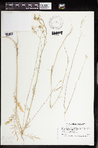 519825[1356080]Smith, Welby 189501991-06-25 United States, Minnesota, Todd, Grey Eagle Wildlife Management Area. Todd Co.; Grey Eagle State Wildlife Management Area, about 3 miles W of Grey Eagle; Todd Co.; Grey Eagle State Wildlife Management Area, about 3 miles W of Grey Eagle; T127N R33W SW1/4 of SE1/4 of sec 10. 127N 33W 10, 45.8191681 -94.815834 |
MIN:Plants | 520523[]Butts, A. 291996-07-12 United States, Minnesota, Lyon, Camden State Park; Lyon Co. - Lyons Township. SE 1/4 of SE 1/4, sec.8, T110N R42W;Camden State Park;110N;42W;8, 44.348463 -95.927263 |
MIN:Plants |  526149[]Lakela, Olga 187621955-07-09 United States, Minnesota, Saint Louis, 2 mi. E of Floodwood on Hwy. 2.;;N;;, 46.929102 -92.877252 |
MIN:Plants | 528962[]Borchard, Alma s.n.1945-06-18 United States, Minnesota, Blue Earth, Along the rr track NW of Mapleton;;N;;, 43.928851 -93.956064 |
MIN:Plants | 551631[]Cotter, Shirley 14061950-06-04 United States, Minnesota, Scott, On bluffs of Minnesota valley above Shakopee;;N;;, 44.798019 -93.526899 |
MIN:Plants | 552159[]Stevens, O. s.n.1958-05-28 United States, Minnesota, Clay, Moorhead, along rr;;139N;48W;, 46.845648 -96.728846 |
MIN:Plants | 553674[]Mielke, Walter 1081958-06-18 United States, Minnesota, Itasca, Ca. 8 mi. N of Nashwauk.;;N;;, 47.496015 -93.168252 |
MIN:Plants | 554375[]Moore, John 231711957-06-12 United States, Minnesota, Pipestone, Pipestone Co.; along the r.r, 1 1/2 miles east of Edgerton.;;105N;44W;, 43.892202 -96.124459 |
MIN:Plants | 558462[]Moore, John 238041958-06-10 United States, Minnesota, Kittson, 3 mi. E of Karlstad.;;N;;, 48.577458 -96.454974 |
MIN:Plants | 560947[]Ownbey, Gerald 27331959-06-24 United States, Minnesota, Clearwater, NW1/4 Sec. 17, T145N, R37W. Along Co. Rd. 35, .8 mi. W of Hwy. 92, ca. 5 mi. NNW of Zerkel.;;145N;37W;17, 47.37654 -95.392939 |
MIN:Plants | 566439[]Moore, John; Heig, V. 241251958-09-10 United States, Minnesota, Kittson, 1/2 mi. NW of Halma.;;N;;, 48.57767 -96.51901 |
MIN:Plants | 572771[]Moore, John 256431961-07-20 United States, Minnesota, Isanti, Old farmstead, W of co. access road, N end of Cedar Creek Natural History Area;Cedar Creek National History Area;034N;23W;, 45.428063 -93.203997 |
MIN:Plants | 572860[]Moore, John 256001961-07-14 United States, Minnesota, Anoka, On laboratory grounds near Cedar Creek Natural History Area.;Cedar Creek National History Area;034N;23W;, 45.428063 -93.203997 |
MIN:Plants | 583374[]Kellner, H. 1421956-06-28 United States, Minnesota, Lake, Lake Co, Station 5, near top of Lafayette Bluff [this is near mouth of Encampment River];North Shore;053N;10W;11, 47.09341 -91.57419 |
MIN:Plants | 592222[]Westkaemper, Remberta s.n.1965-05-00 United States, Minnesota, Stearns, Stearns Co. St. Joseph;;124N;29W;, 45.543642 -94.322053 |
MIN:Plants | 603909[]Moore, John; Moore, Marjorie 271301967-06-09 United States, Minnesota, Pipestone, E of the headquarters building, Pipestone National Monument.;Pipestone National Monument;106N;46W;, 43.979723 -96.367859 |
MIN:Plants | 611330[]Hsi, Yu-tseng [Eugene] 9891969-06-30 United States, Minnesota, Lyon, Along rr tracks 3.5 mi S of Marshall on hwy 59;;N;;, 44.39624 -95.75546 |
MIN:Plants | 616414[]Moore, John; Moore, Marjorie 4291969-08-08 United States, Minnesota, Crow Wing, S line of the NW1/4 Sec. 20 Garrison Twp.;;N;;20, 46.279654 -93.90513 |
MIN:Plants | 678921[]Ownbey, Gerald 49361975-06-27 United States, Minnesota, Clearwater, 6.8 mi. N of Clearbrook, W side of Rte. 5.;;N;;, 47.79709 -95.441153 |
MIN:Plants | 681115[]Swanson, Steven 9441975-06-25 United States, Minnesota, Houston, Mississippi River (Navigation Pool #8). Houston Co. R.R. levee.;Upper Mississippi National Wildlife Refuge;N;;, 43.763684 -91.282376 |
MIN:Plants | 681153[]Swanson, Steven 4731975-06-13 United States, Minnesota, Houston, Mississippi River (Navigation Pool #8). Houston Co. Site 9. R.R. bank on W side of chanel.;Upper Mississippi National Wildlife Refuge;N;;, 43.763684 -91.282376 |
MIN:Plants | 681250[]Swanson, Steven 5171975-06-14 United States, Minnesota, Winona, Mississippi River Navigation Pool #8. Winona Co, Site 11. R.R. bank on the W side of the main channel.;Upper Mississippi National Wildlife Refuge;105N;04W;, 43.873038 -91.336459 |
MIN:Plants | 685042[]Stassen, Carol 251976-06-18 United States, Minnesota, Lyon, Camden State Park; T110N, R42W, Sec. 5. Old gravel pit site, near park entrance.;Camden State Park;110N;42W;5, 44.363323 -95.947736 |
MIN:Plants | 687059[]Wheeler, Gerald; Glaser, Paul 14851977-05-28 United States, Minnesota, Itasca, Collection Site no. 33, ca. 8.5 mi SW of Grand Rapids; SW1/4 NW1/4 Sec. 28 T54N R26W;;054N;26W;28, 47.130995 -93.651027 |
MIN:Plants | 687382[]Wheeler, Gerald; Glaser, Paul 18191977-06-28 United States, Minnesota, Itasca, Site 74. SW1/4 NW1/4 Sec. 22, T54N, R25W; ca. 6 mi. SSE of Grand Rapids. Near the edge of a gravel pit adjacent to Hwy Site 74. SW1/4 NW1/4 Sec. 22, T54N, R25W; ca. 6 mi. SSE of Grand Rapids. Near the edge of a gravel pit adjacent to Hwy. 66.. 054N 25W 22, 47.145263 -93.502181 |
MIN:Plants | 691180[]Sperling, C. 2181976-05-30 United States, Minnesota, Douglas, 1/4 mi. S of Alexandria Tech. School.;;N;;, 45.88162 -95.377538 |
MIN:Plants | 696540[]Smith, Welby 7581978-05-28 United States, Minnesota, Wright, Burlington Northern right-of-way; T122N R25W N1/2 Sec. 32;;122N;25W;32, 45.331907 -93.860001 |
MIN:Plants | 701074[]Dorio, J. 3621977-06-27 United States, Minnesota, Morrison, Ripley Esker, ca. 3 mi NE of Camp Ripley Junction; T42N R31W Sec. 19;Ripley Esker Scientific Natural Area;042N;31W;19, 46.106283 -94.30299 |
MIN:Plants | 724994[]Smith, Welby 29611980-07-20 United States, Minnesota, Wright, Beach on W bank of the Mississippi River, ca. 1/8 mi S of st. hwy 101 crossing; T121N R23W SW1/4 Sec. 14;;121N;23W;14, 45.284891 -93.558229 |
MIN:Plants | 727168[]Herman, J. 821979-07-10 United States, Minnesota, Norman, Twin Valley Prairie, 5 mi W of Syre; NW1/4 E1/2 SW1/4 Sec. 23 T143N R45W;Twin Valley Prairie Scientific Natural Area;143N;45W;23, 47.187516 -96.353808 |
MIN:Plants | 727685[]Lustig, K. 8241979-08-08 United States, Minnesota, Sherburne, Mississippi River Islands Scientific Natural Area. Sherburne & Wright Cos. ...Mississippi Scenic and Recreational River Islands SNA: Mississippi River Islands between Monticello and Elk River, Sec. 2, 3, 4, T32N, R26W, 27W; Sec. 7, 9, 18, T121N, R23W, 24W.. 032N 26W 3, 45.293483 -93.556246 |
MIN:Plants | 727779[]Ottoson, S. 951979-07-25 United States, Minnesota, Clay, Clay County Bicentennial Prairie, 4 mi SE of Felton; SW1/4 Sec. 5 T141N R45W;Felton Prairie-Bicentennial Prairie Scientific Natural Area;141N;45W;5, 47.056714 -96.417356 |
MIN:Plants | 728140[]Eikum, B. 1861979-07-26 United States, Minnesota, Dakota, Hastings;Hastings Scientific Natural Area;115N;17W;, 44.73907 -92.86266 |
MIN:Plants | 728327[]Lustig, K. 5491979-06-26 United States, Minnesota, Sherburne, Mississippi River Islands Scientific Natural Area. Sherburne & Wright Cos. ...Mississippi Scenic and Recreational River Islands SNA, Mississippi River Islands between Monticello and Elk River. Sec. 2, 3, 4, T32N, R26, 27W; sec. 7, 9, 18, T121N, R23, 24W. 032N 26W 3, 45.29348 -93.55625 |
MIN:Plants | 734836[]Petron, T. 2471980-07-14 United States, Minnesota, Clay, Bluestem Prairie: 13 mi. E of Moorhead. E riverbank of the Buffalo River. NW1/4 NE1/4 Sec. 15, T139N, R46W.;;139N;46W;15, 46.854948 -96.473403 |
MIN:Plants | 738521[]Galatowitsch, S. 3741982-07-01 United States, Minnesota, Wabasha, [no further data];Kellogg-Weaver Dunes Scientific Natural Area / Kellogg-Weaver Dunes, The Nature Conservancy;109N;09W;, 44.2331079 -91.9172451 |
MIN:Plants | 741383[]Converse, C. 13441982-06-27 United States, Minnesota, Chippewa, Chippewa and Swift Cos. Chippewa Prairie; NE1/4 NW1/4 Sec. 13 T119N R43W;Chippewa Prairie, The Nature Conservancy;119N;43W;13, 45.110235 -95.996766 |
Google Map
Google Maps is a web mapping service provided by Google that features a map that users can pan (by dragging the mouse) and zoom (by using the mouse wheel). Collection points are displayed as colored markers that when clicked on, displays the full information for that collection. When multiple species are queried (separated by semi-colons), different colored markers denote each individual species.