University of Minnesota
http://www.umn.edu/
612-625-5000
http://www.umn.edu/
612-625-5000
Minnesota Biodiversity Atlas
Bell Museum
Dataset: MIN-Plants
Taxa: Brassicaceae
Search Criteria: excluding cultivated/captive occurrences
Bell Museum plants | |
 MIN:Plants | 741388[]Converse, C. 11951982-06-18 United States, Minnesota, Pope, Ordway Prairie; NE1/4 NE1/4 Sec. 30 T123N R36W;Ordway Prairie, The Nature Conservancy;123N;36W;30, 45.434262 -95.245018 |
MIN:Plants | 745011[]Smith, Welby 42491981-06-13 United States, Minnesota, Wright, Ca. 1 3/4 mi. SE of Silver Creek, and S of Co. Hwy. 39. NW1/4 NW1/4 Sec. 15, T121N, R26W.;;121N;26W;15, 45.289406 -93.943204 |
MIN:Plants | 795963[]Smith, Welby 39971981-05-30 United States, Minnesota, Wright, On the W side of Co. Hwy. 7, ca. 1 1/4 mi. N of it's jct. with Hwy. 55 near Maple Lake. SE1/4 NW1/4 Sec. 36, T121N, R27 On the W side of Co. Hwy. 7, ca. 1 1/4 mi. N of it's jct. with Hwy. 55 near Maple Lake. SE1/4 NW1/4 Sec. 36, T121N, R27W.. 121N 27W 36, 45.245776 -94.02489 |
MIN:Plants | 802906[]Smith, Welby 120111986-07-03 United States, Minnesota, Scott, Minnesota Valley National Wildlife Refuge. Scott County...The Louisville Swamp area, in the Minnesota Valley National Wildlife Refuge; about 6 mi. S of Shakopee. NW1/4 SW1/4 Sec. 28, T115N, R23W. 115N 23W 28, 44.7355556 -93.5988889 |
MIN:Plants |  814179[1356081]Wheeler, Gerald 108731988-06-25 United States, Minnesota, Wilkin, Breckenridge (W side); Welles Memorial Park. Near Otter Tail River. NW1/4 Sec. 9, T132N, R47W (Breckenridge Twp.);;132N;47W;9, 46.26131 -96.584721 |
MIN:Plants | 814639[]Wheeler, Gerald 112091988-07-19 United States, Minnesota, Big Stone, Barry Lake Wildlife Management Area. Big Stone Co.; Ca. 1.2 mi. NW of Barry; ca. 0.3 mi. E of Rte. 57. Between Barry Lake and the road. SE1/4 NW1/4 Sec. 8, T124N, R47W (Toqua Twp.).. 124N 47W 8, 45.565691 -96.586118 |
MIN:Plants |  815863[1356082]Wheeler, Gerald 109321988-06-26 United States, Minnesota, Traverse, Ca. 4.5 mi. SW of Wheaton; N of Rte. 27. Near the Mustinka River (S bank). NW1/4 NE1/4 Sec. 33, T127N, R47W (Lake Twp. Ca. 4.5 mi. SW of Wheaton; N of Rte. 27. Near the Mustinka River (S bank). NW1/4 NE1/4 Sec. 33, T127N, R47W (Lake Twp.). 127N 47W 33, 45.767024 -96.583292 |
MIN:Plants | 833674[]Smith, Welby 142641988-06-17 United States, Minnesota, Washington, Washington Co.; S side of Mahtomedi. SE1/4 SE1/4 sec.31, T30N R21W;;030N;21W;31, 45.043008 -92.97472 |
MIN:Plants | 833877[]Smith, Welby 141731988-06-01 United States, Minnesota, Lac Qui Parle, Big Stone National Wildlife Refuge. Lac Qui Parle Co. Big Stone National Wildlife Refuge, about 7 mi NW of Bellingham, in the Minnesota Valley; NE1/4 SW1/4 Lac Qui Parle Co. Big Stone National Wildlife Refuge, about 7 mi NW of Bellingham, in the Minnesota Valley; NE1/4 SW1/4 sec 1, T120N R46W.. 120N 46W 1, 45.233115 -96.363845 |
MIN:Plants | 841716[]Smith, Welby 145641988-07-20 United States, Minnesota, Washington, Cottage Grove Ravine Regional Park. Washington County...Cottage Grove Ravine Regional Park, about 2 mi SE of Cottage Grove...N shore of a small unnamed lake...SE1/4 SE1/4 sec.22, T27N R21W. 027N 21W 22, 44.8077778 -92.9033333 |
MIN:Plants |  454171[1356077]Bosch, T. 62002-05-10 United States, Minnesota, Big Stone, Big Stone County ... Approx. 0.5 east of Hwy. 75 and 2 miles south of Hwy. 7 ... T120N R45W sec. 1-2;Lac Qui Parle Wildlife Management Area;120N;45W;1-2, 45.2325 -96.23654 |
MIN:Plants | 914369[]Smith, Welby 225441993-06-22 United States, Minnesota, Stevens, Stevens County...Between TH 9 and the BN railroad tracks, about 4 miles south-southeast of Donnelly...T 125N R 42W NW1/4 of NE1/4 of Sec 17. 125N 42W 17, 45.6427778 -95.9752778 |
MIN:Plants | 794619[]Schaaf, J. 1171982-07-08 United States, Nevada, Carson City, Carson City Co. ... Prison Hill ... Elev: 5100 ft. |
MIN:Plants | 509256[]Wheeler, Gerald 194491998-06-25 United States, Minnesota, Sibley, Sibley County ... Ca. 8.5 mi. ESE of Green Isle; 4.5 mi. WSW of jct. of rte. 6 and Rte. 25; N of road (Rte. 6) ... N1/2 NE1/4 Sec. 5 T113N R25W. 113N 25W 5, 44.618979 -93.852531 |
MIN:Plants | 681189[]Swanson, Steven 6621975-06-18 United States, Wisconsin, La Crosse, Mississippi River (Navigation Pool #8)...La Crosse Co, Site 20;Upper Mississippi National Wildlife Refuge |
MIN:Plants | 297473[]Benner, F.; et al. 1901928-08-02 United States, Wisconsin, Polk, 6 mi. N. St. Croix Falls on River road;Saint Croix National Riverway;;;, 45.481172 -92.687024 |
MIN:Plants | 453010[]Davis, Owen s.n.1978-08-21 United States, Idaho, Bingham, [no further data] |
MIN:Plants |  494871[1356084]Bosch, T. 102002-06-22 United States, Minnesota, Big Stone, Lac Qui Parle Wildlife Management Area. Big Stone County ... Lac Qui Parle Wildlife Area ... Approx. 0.5 east of Hwy. 75 and 2 miles south of Hwy. 7 ... T120N R45W sec. 1-2. 120N 45W 42371, 45.2325 -96.236536 |
MIN:Plants | 484256[]Juhnke, C. 364 CMJ FRO1999-06-17 United States, Minnesota, Goodhue, Frontenac State Park Goodhue County ... Restored prairie east of contact station ...T112N R13W NE SE NW 11;Frontenac State Park;112N;13W;11, 44.51999 -92.339224 |
MIN:Plants | 478134[]Wheeler, Gerald 189721998-06-09 United States, Minnesota, Carver, Carver County ... Ca. 2.5 mi. E of East Union on Rte. 50, S of raod ... E1/2 NE1/4 Sec. 6 T114N R23W;;114N;23W;6, 44.710544 -93.63374 |
MIN:Plants | 453011[]Davis, Owen s.n.1978-08-28 United States, Idaho, Butte, Butte Co. |
MIN:Plants | 575488[]Garton, C. 85141961-07-01 Canada, Ontario, Rainy River, Rainy River District...Rainy R. 1 mi. W. of Rainy R. Town, Atwood Twp. |
MIN:Plants | 921161[]Smith, Welby 236291993-08-13 United States, Minnesota, Kandiyohi, About 3.5 miles northwest of New London...T122N R33W NE1/4 of SW1/4 of Sec 31;;122N;33W;31, 45.333424 -94.875828 |
MIN:Plants | 933490[]Smith, Welby R. 213461992-08-11 United States, Minnesota, Marshall, About 5 miles west of Middle River (town), on the north side of CSAH 6. SW1/4 of SW1/4 of section;;157N;44W;01, 48.4097222 -96.275 |
MIN:Plants |  972692[1398245]Janssens, J. 231974-04-15 Belgium, L. O. |
MIN:Plants | 978205[1401614]Don Henson 5781974-07-03 United States, Michigan, Schoolcraft, In Manistique., 45.961491 -86.25102 |
MIN:Plants | Barbarea orthoceras Ledebour 117684[]Scheuber, E. s.n.1902-07-10 United States, Wyoming, Park, Yellowstone National Park...Norris Y.N.P.;Yellowstone National Park;;;, 44.758869 -110.411858 |
MIN:Plants | Barbarea orthoceras Ledebour 382600[]Morse, Marius s.n.1944-07-27 United States, Alaska, Aleutian Islands ... Adak Island;Aleutian Islands Wilderness;;;, 51.88 -176.65806 |
MIN:Plants | Barbarea orthoceras Ledebour 117652[]Nelson, Aven; et al. 55171899-06-23 United States, Wyoming, Park, Yellowstone National Park...Madison River;Yellowstone National Park;;;, 44.66475 -110.98251 |
MIN:Plants | Barbarea orthoceras Ledebour 117691[]Roberts, Thomas s.n.1878-00-00 United States, Minnesota, Lake, Two Harbors;North Shore;052N;11W;, 47.02278 -91.67056 |
MIN:Plants | Barbarea orthoceras Ledebour 117711[]Sheldon, Edmund S.27721892-07-00 United States, Minnesota, Mille Lacs, Milaca;;038N;27W;25, 45.756966 -93.647572 |
MIN:Plants | Barbarea orthoceras Ledebour 360902[]Moyle, J. 35021940-06-23 United States, Minnesota, Lake, Near Two Harbors.;;N;;, 47.022711 -91.670732 |
MIN:Plants | Barbarea orthoceras Ledebour 391918[]Lakela, Olga 661900-12-07 United States, Minnesota, Lake, at the Springs, Tofte - Isabella Road. Lake Co.;Superior National Forest;;;, 47.621575 -91.41126 |
MIN:Plants | Barbarea orthoceras Ledebour 393135[]Ownbey, Gerald; et al. 10951948-08-16 United States, Minnesota, Cook, Cook County...southwest end of Lucille Island (just across from Sailboat I), Susie Islands near Grand Portage.;North Shore / Susie Islands, The Nature Conservancy;063N;07E;05, 47.964054 -89.577589 |
MIN:Plants | Barbarea orthoceras Ledebour 422608[]Lakela, Olga 74931948-06-15 United States, Minnesota, Carlton, Near Esko.;;N;;, 46.705776 -92.363247 |
MIN:Plants |  Barbarea orthoceras Ledebour 442712[1351634]Lakela, Olga 124061951-06-09 United States, Minnesota, Saint Louis, off Floodwood River, 7 mi. north of Floodwood, St. Louis Co.;;052N;20W;06, 47.01874 -92.920954 |
MIN:Plants | Barbarea orthoceras Ledebour 525570[]Lakela, Olga 185991955-05-28 United States, Minnesota, Saint Louis, St. Louis County...Floodwood River...Highway 73, near Meadowlands Jct.;;053N;21W;22, 47.063039 -92.984321 |
MIN:Plants | Barbarea orthoceras Ledebour 551364[]Cotter, Shirley 19301951-06-24 United States, Minnesota, Anoka, Anoka County...along nursery road, Carlos Avery Game Refuge.;Carlos Avery Wildlife Management Area;033N;22W;, 45.340658 -93.081463 |
MIN:Plants |  Barbarea orthoceras Ledebour 773139[1351633]Boe, J. 1841979-06-15 United States, Minnesota, Lake of the Woods, Lake of the Woods County...Wheeler's Point...near shore of Lake of the Woods...T162N, R32W, NE1/4 Sec. 24.;;162N;32W;24, 48.837713 -94.708013 |
MIN:Plants |  Barbarea orthoceras Ledebour 583325[1351635]Kellner, H. 5121956-07-18 United States, Minnesota, Cook, Cook County...Along roadside near Mineral Center.;Grand Portage Indian Reservation / North Shore;063N;05E;10, 47.954589 -89.791475 |
MIN:Plants | Barbarea orthoceras Ledebour 525568[]Hardy, Robert 1981945-07-14 United States, Alaska, Aleutian Islands ... Attu Island ... Bassett Creek, Sidden's Valley;Aleutian Islands Wilderness;;;, 52.884659 -173.213793, 61m |
MIN:Plants | Barbarea orthoceras Ledebour 657312[]Noble, Mark; et al. 4831974-08-05 United States, Alaska, Muir Point; from site deglaciated ca. 1880.;Glacier Bay National Park;;;, 58.82694 -136.07722 |
MIN:Plants | 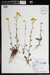 Barbarea orthoceras Ledebour 966389[1359228]Timothy J. S. Whitfeld 27722021-05-13 United States, Minnesota, Washington, Lost Valley Prairie Scientific and Natural Area, 2 miles east north east of intersection of State Highway 95 and 110th., 44.800068 -92.823127, 276m |
MIN:Plants | Erysimum capitatum (Douglas ex Hooker) Greene 604196[]Bent, Anne 59062401021959-06-24 United States, New Mexico, San Juan, Chuska Mountains...Lake D. Dead Man Lake, crest of mountains west of Toadlena...3 miles west of Toadlena.;Navaho Indian Reservation, 2774m |
MIN:Plants | Erysimum capitatum (Douglas ex Hooker) Greene 453019[]Univ. of Calif. Bot. Gard. list 17 - 231974-00-00 United States, California, Colusa, Colusa Co. |
MIN:Plants | 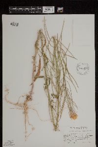 Erysimum capitatum (Douglas ex Hooker) Greene 611205[1299170]Mallory, J. 3161968-07-17 United States, California, Tulare, Mountain Home State Forest Headquarters, Sequoia National Forest, Tulare County, 1821m |
MIN:Plants | Eutrema edwardsii R. Brown 409393[]Spetzman, L. 20221949-07-17 United States, Alaska, Arctic North Slope...Kanayut Lake;Gates of the Arctic National Park;;;, 68.3333333 -151, 914m |
MIN:Plants | Eutrema edwardsii R. Brown 409411[]Spetzman, L. 27371949-07-07 United States, Alaska, Arctic North Slope...Anaktuvk [sic] Pass;Gates of the Arctic National Park;;;, 68.2833333 -151.4166667, 914m |
MIN:Plants | Eutrema edwardsii R. Brown 403344[]Spetzman, L. 12991948-08-17 United States, Alaska, Arctic North Slope...Sadlerochit River;Arctic National Wildlife Refuge;;;, 69.5833333 -144.75, 457m |
MIN:Plants | Eutrema edwardsii R. Brown 403354[]Spetzman, L. 12141948-09-04 United States, Alaska, Arctic North Slope ... Barter Island;Arctic National Wildlife Refuge;;;, 70.121454 -143.67307, 2m |
MIN:Plants | Eutrema edwardsii R. Brown 416995[]Spetzman, L. 38051950-07-04 United States, Alaska, Arctic North Slope...Kurupa Lake;Gates of the Arctic National Park;;;, 68.3666667 -154.6666667, 945m |
MIN:Plants | Eutrema edwardsii R. Brown 403569[]Spetzman, L. 13001948-07-19 United States, Alaska, Arctic North Slope ... Lake Peters;Arctic National Wildlife Refuge;;;, 69.3333333 -145, 914m |
MIN:Plants | Stanleya elata M.E. Jones 492708[]Williams, M. s.n.1983-00-00 United States, California, Inyo, White Mts, Westguard [sic] Pass, Inyo Co., 2216m |
MIN:Plants | 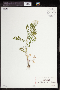 911590[1352599]Cholewa, A. 26312009-06-07 United States, Minnesota, Hennepin, Fort Snelling State Park. Dakota County [this locality actually in Hennepin Co.], Fort Snelling State Park, along trail on north side of Snelling Lake. T28N R23W Sec 28. 028N 23W 28, 44.882343 -93.174242 |
MIN:Plants | 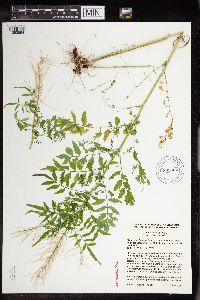 905507[1352594]Cholewa, A. 26142008-07-16 United States, Minnesota, Ramsey, Hidden Falls - Crosby Farm Regional Park. Ramsey County, Hidden Falls Park, near north boundary, less than 100 yds from bluff, along little used path. T28N R23W Sec 17 SW1/4. 028N 23W 17, 44.910761 -93.195706 |
MIN:Plants |  905498[1352595]Cholewa, A. 26182008-07-16 United States, Minnesota, Ramsey, Hidden Falls - Crosby Farm Regional Park. Ramsey County, Hidden Falls Park, south unit, about 100 yards from bluffs just southeast of parking area. T28N R23W Sec 21. 028N 23W 21, 44.894603 -93.176994 |
MIN:Plants |  905516[1352597]Cholewa, A. 26102008-07-03 United States, Minnesota, Ramsey, Ramsey County, Hidden Falls Park, northend, northwest of picnic area. T28N R23W Sec 17 SW 1/4;Hidden Falls - Crosby Farm Regional Park;028N;23W;17, 44.908847 -93.197122 |
MIN:Plants |  905499[1352596]Cholewa, A. 26192008-07-16 United States, Minnesota, Ramsey, Hidden Falls - Crosby Farm Regional Park. Ramsey County, Crosby Farm Park, along path leading to bluffs abuot 100 feet from Y juction of west end of Wetland Trail; about 150 yards from bluffs. T28N R23W Sec 22 NW of NE 1/4. 028N 23W 22, 44.90161 -93.150973 |
MIN:Plants | 923921[]Jacobs, Tamberlain; Liu, O. s.n.2011-06-11 United States, Minnesota, Dakota, Inver Grove Heights, Macalester College's Katherine Ordway Natural History Study Area. Adjacent to River Lake - Mississippi River.. 027N 22W 22, 44.8 -93.0166667 |
MIN:Plants |  924818[1352598]Chayka, K. KC-11032011-06-05 United States, Minnesota, Ramsey, Bike/hiking trail in the woods at Battle Creek West, east of Douglas Point Rd parking lot. NE1/4 of section;Battle Creek County Park;030N;23W;20, 45.0744444 -93.19 |
MIN:Plants | 198508[]Cholewa, A.; Allen, Kathy 28432013-06-15 United States, Minnesota, Hennepin, Minneapolis, Coldwater Spring Unit (adjacent to Minnehaha Park).;Mississippi National River & Recreational Area;;;, 44.90039 -93.19606 |
MIN:Plants | 938997[]Chandler, Monika s.n.2009-07-02 United States, Minnesota, Washington, St. Paul Park. Riverside Park., 44.8351569 -93.0033458 |
MIN:Plants |  953103[1291720]Gernes, Carole J. 212016-04-25 United States, Minnesota, Ramsey, Tamarack Nature Center. White Bear Township. Trailside; in wooded area west of bluebird trail, on the west side of interpretive building., 45.1022 -93.0419 |
MIN:Plants |  953099[1291716]Gernes, Carole J. 172016-05-20 United States, Minnesota, Ramsey, Maplewood Nature Center. City of Maplewood. NE side of interpretive building: 2659 7th St. E. 55119., 44.967508 -92.98824 |
MIN:Plants |  976003[1373556]Smith, Welby R WRS367162020-06-23 United States, Minnesota, Dakota, Lake Rebecca Park; on the north side of Hastings just south of Lock and Dam #2 on the Mississippi River., 44.75391 -92.8702 |
MIN:Plants |  976049[1373602]Smith, Welby R WRS367362020-06-28 United States, Minnesota, Dakota, Pine Bend State Scientific and Natural Area. In Inver Grove Heights, about 15 km (9.3 miles) W-NW of the Mississippi River Bridge in Hastings at a heading of 290 degrees., 44.79179 -93.03081 |
MIN:Plants | Smelowskia borealis (Greene) W.H. Drury & Rollins 700243[]Glaser, Paul 5701974-06-22 United States, Alaska, Mt. McKinley Nat. Park...SW1/4SW1/4Sec.22 T17S R14W, vicinity of Gravel Mtn.;Denali National Park;017S;14W;22, 1463m |
MIN:Plants | Smelowskia borealis (Greene) W.H. Drury & Rollins 700242[]Glaser, Paul 5881974-06-10 United States, Alaska, Mt. McKinley Nat. Park...NW1/4SW1/4Sec.18 T17S R14W, Thorofare Bluffs;Denali National Park;017S;14W;18, 1433m |
MIN:Plants | Smelowskia borealis (Greene) W.H. Drury & Rollins 539723[]Viereck, Les 13811956-07-17 United States, Alaska, Mt. McKinley Nat. Park...Junction of the Muldrow Glacier and the glacier from Anderson Pass;Denali National Park;;;, 63.3 -150.3, 1524m |
MIN:Plants | Smelowskia borealis (Greene) W.H. Drury & Rollins 700302[]Glaser, Paul 5421974-06-10 United States, Alaska, Mt. McKinley Nat. Park...NW1/4SW1/4Sec.18 T17S R14W, Thorofare Bluffs;Denali National Park;017S;14W;18, 1402m |
MIN:Plants | Smelowskia borealis (Greene) W.H. Drury & Rollins 700005[]Priebe, Ronald s.n.1972-06-00 United States, Alaska, Mt. McKinley Nat. Park...Mt. Tatum;Denali National Park |
MIN:Plants | Boechera lyallii (S. Watson) Dorn 550327[]Cotter, Shirley 11841950-07-27 United States, Montana, Logan Pass, Glacier Park;Glacier National Park |
MIN:Plants | Boechera lyallii (S. Watson) Dorn 233275[]Congdon, J. s.n.1898-08-25 United States, California, Tuolumne, Mt. Warren, Tuolumne County;Yosemite National Park |
MIN:Plants | Boechera lyallii (S. Watson) Dorn 117503[]Nelson, Aven; et al. 66981899-08-27 United States, Wyoming, Park, Yellowstone National Park...Dunraven Peak;Yellowstone National Park |
MIN:Plants | Boechera lyallii (S. Watson) Dorn 565113[]Cotter, Shirley 13451950-08-01 United States, Montana, Glacier, Logan Pass...Glacier Park, Glacier Co.;Glacier National Park, 2012m |
MIN:Plants | Boechera lyallii (S. Watson) Dorn 565017[]Cotter Tucker, Shirley 30701951-08-07 United States, Montana, Garden Wall trail...Glacier Park;Glacier National Park, 2438m |
MIN:Plants | Arabis blepharophylla Hooker & Arnott 453034[]Univ. of Calif. Bot. Gard. list 18 - 421976-00-00 United States, California, Marin, Marin Co. |
MIN:Plants | Physaria reediana O'Kane & Al-Shehbaz 120041[]Leiberg, John s.n.1880-07-00 United States, Idaho, Kootenai, Kootenai Co. |
MIN:Plants | Physaria reediana O'Kane & Al-Shehbaz 120046[]Kelsey, F. s.n.1892-05-20 United States, Montana, Lewis and Clark, Helena |
MIN:Plants | Physaria reediana O'Kane & Al-Shehbaz 120042[]Kelsey, F. s.n.1888-06-05 United States, Montana, Lewis and Clark, Helena |
MIN:Plants | Physaria reediana O'Kane & Al-Shehbaz 120036[]Kelsey, F. s.n.1888-06-11 United States, Montana, Lewis and Clark, Helena |
MIN:Plants | Physaria reediana O'Kane & Al-Shehbaz 120037[]Kelsey, F. s.n.1892-06-20 United States, Montana, Lewis and Clark, Helena |
MIN:Plants | Physaria reediana O'Kane & Al-Shehbaz 120044[]Anderson, F. 371886-06-06 United States, Montana, Cascade, Great Falls |
MIN:Plants | Physaria reediana O'Kane & Al-Shehbaz 120043[]Kelsey, F. s.n.1892-05-20 United States, Montana, Lewis and Clark, Helena |
MIN:Plants | Erucastrum gallicum (Willdenow) O.E. Schultz 604511[]Stevens, O. 30561967-10-20 United States, North Dakota, Cass, Cass County...on campus [North Dakota State University]. Fargo |
MIN:Plants | Erucastrum gallicum (Willdenow) O.E. Schultz 552105[]Stevens, O. 20111958-08-29 United States, North Dakota, Traill, Galesburg (Traill Co.) |
MIN:Plants | Erucastrum gallicum (Willdenow) O.E. Schultz 355982[]Stevens, O. s.n.1911-07-25 United States, North Dakota, Cass, G.N. Ry tracks. Fargo |
MIN:Plants | Erucastrum gallicum (Willdenow) O.E. Schultz 355981[]Stevens, O. s.n.1914-10-26 United States, North Dakota, Cass, Fargo. |
MIN:Plants | Erucastrum gallicum (Willdenow) O.E. Schultz 911749[]Cholewa, A. 26752009-08-07 United States, Minnesota, Anoka, Martin-Island-Linwood Lakes County Park. Anoka County, Linwood Lake County Park, boat ramp at northeast end of lake, along man-made fishing peninsula west of ramp. T33N R22W Sec 9.. 033N 22W 9, 45.362784 -93.091567 |
MIN:Plants |  Erucastrum gallicum (Willdenow) O.E. Schultz 480889[1352979]Anderson, Craig 10462000-07-25 United States, Minnesota, Becker, Becker County ... Read WPA ... T141N R42W: 1/4 of NE1/4 of NE1/4 of Sect. 8;Read Wildlife Management Area / White Earth Indian Reservation;141N;42W;08, 47.042851 -96.02958 |
MIN:Plants | Erucastrum gallicum (Willdenow) O.E. Schultz 575258[]Garton, C. 94391961-08-18 Canada, Ontario, Rainy River, Rainy River District...C.N.R, 1/2 mi. W. of Rainy R. Town, Atwood Twp. |
MIN:Plants | Erucastrum gallicum (Willdenow) O.E. Schultz 118720[]Rosendahl, C. 49091925-08-11 United States, Minnesota, Pipestone, Along r.r. yard, Pipestone;;106N;46W;, 43.979723 -96.367859 |
MIN:Plants | Erucastrum gallicum (Willdenow) O.E. Schultz 118721[]Rosendahl, C. 49091925-08-11 United States, Minnesota, Pipestone, Pipestone;;106N;46W;, 43.979723 -96.367859 |
MIN:Plants | Erucastrum gallicum (Willdenow) O.E. Schultz 337025[]Lakela, Olga 16831936-08-08 United States, Minnesota, Saint Louis, Oatka Beach Addition at 42nd St, near Minnesota Ave, Duluth.;Minnesota Point;049N;13W;18, 46.741215 -92.062388 |
MIN:Plants | Erucastrum gallicum (Willdenow) O.E. Schultz 337030[]Lakela, Olga 17651936-08-19 United States, Minnesota, Saint Louis, Sec. 18, Duluth.;;N;;, 46.783273 -92.106579 |
MIN:Plants | Erucastrum gallicum (Willdenow) O.E. Schultz 337826[]Rosendahl, C.; Moyle, J. 21901936-07-18 United States, Minnesota, Beltrami, 8 mi. N of Waskish.;;N;;, 48.277137 -94.512455 |
MIN:Plants | Erucastrum gallicum (Willdenow) O.E. Schultz 351086[]Hedman, H. 891938-07-00 United States, Minnesota, Hennepin, N shore Smith's Bay, Lake Minnetonka.;;N;;, 44.95245 -93.5682 |
MIN:Plants | Erucastrum gallicum (Willdenow) O.E. Schultz 352354[]Rosendahl, C. s.n.1936-10-04 United States, Minnesota, Anoka, Moore Lake.;;030N;24W;, 45.080985 -93.255535 |
MIN:Plants | Erucastrum gallicum (Willdenow) O.E. Schultz 354264[]Moyle, J. 14931934-07-18 United States, Minnesota, Pennington, Thief River Falls;;N;;, 48.122984 -96.171962 |
MIN:Plants | Erucastrum gallicum (Willdenow) O.E. Schultz 354584[]Moyle, J. 13181934-07-18 United States, Minnesota, Pennington, Bank of Thief River, Thief River Falls.;;N;;, 48.122984 -96.171962 |
Google Map
Google Maps is a web mapping service provided by Google that features a map that users can pan (by dragging the mouse) and zoom (by using the mouse wheel). Collection points are displayed as colored markers that when clicked on, displays the full information for that collection. When multiple species are queried (separated by semi-colons), different colored markers denote each individual species.