University of Minnesota
http://www.umn.edu/
612-625-5000
http://www.umn.edu/
612-625-5000
Minnesota Biodiversity Atlas
Bell Museum
Dataset: MIN-Plants
Taxa: Brassicaceae
Search Criteria: excluding cultivated/captive occurrences
Bell Museum plants | |
 MIN:Plants | Erucastrum gallicum (Willdenow) O.E. Schultz 354809[]Lakela, Olga 26591938-07-31 United States, Minnesota, Saint Louis, Near park grounds on Superior bayside, Duluth.;;N;;, 46.749102 -92.076944 |
MIN:Plants | Erucastrum gallicum (Willdenow) O.E. Schultz 355980[]Stevens, O. s.n.1932-09-05 United States, Minnesota, Lake of the Woods, [no further data];;;;, 48.75056 -94.91667 |
MIN:Plants | Erucastrum gallicum (Willdenow) O.E. Schultz 356655[]Lakela, Olga 31241939-07-09 United States, Minnesota, Saint Louis, Beach addition, adjoining the recreation grounds, Minnesota Point, Duluth.;Minnesota Point;049N;13W;18, 46.740274 -92.061358 |
MIN:Plants | Erucastrum gallicum (Willdenow) O.E. Schultz 359278[]Alaspa, E.; Alaspa, H. s.n.1940-08-05 United States, Minnesota, Stearns, Stearns Co. 2 mi E of Georgeville.;;123N;33W;, 45.456157 -94.824482 |
MIN:Plants | Erucastrum gallicum (Willdenow) O.E. Schultz 360240[]Lakela, Olga 42321940-09-01 United States, Minnesota, Saint Louis, St. Louis River bank at Morgan Park, Duluth.;;N;;, 46.692719 -92.203525 |
MIN:Plants | Erucastrum gallicum (Willdenow) O.E. Schultz 362542[]Rosendahl, C.; et al. 70591938-09-04 United States, Minnesota, Marshall, 2 mi. S Holt.;;;;, 48.26297 -96.192531 |
MIN:Plants | Erucastrum gallicum (Willdenow) O.E. Schultz 370509[]Moore, John 132111940-06-22 United States, Minnesota, Renville, 1 mi. E of Fairfax. Renville Co.;;112N;32W;, 44.499212 -94.684548 |
MIN:Plants | Erucastrum gallicum (Willdenow) O.E. Schultz 393510[]Stevens, O. s.n.1947-07-26 United States, Minnesota, Clay, Glyndon;;139N;47W;11, 46.869895 -96.578669 |
MIN:Plants | Erucastrum gallicum (Willdenow) O.E. Schultz 393520[]Stevens, O. s.n.1947-08-18 United States, Minnesota, Clay, [no further data];Buffalo River State Park;139N;46W;10, 46.869327 -96.473428 |
MIN:Plants | Erucastrum gallicum (Willdenow) O.E. Schultz 394075[]Oldenburg, Margaret s.n.1944-11-00 United States, Minnesota, Cook, Near Coast Guard Station, Grand Marais.;North Shore;061N;01E;, 47.777456 -90.325243 |
MIN:Plants | Erucastrum gallicum (Willdenow) O.E. Schultz 407761[]Lakela, Olga 93271949-08-13 United States, Minnesota, Saint Louis, Prairie Lake.;;N;;, 46.79124 -92.904888 |
MIN:Plants | Erucastrum gallicum (Willdenow) O.E. Schultz 412250[]Moore, John; Moore, Marjorie 114311939-08-03 United States, Minnesota, Roseau, On the r.r. right-of-way near the Longworth School;;N;;, 48.982491 -95.364961 |
MIN:Plants | Erucastrum gallicum (Willdenow) O.E. Schultz 412703[]Moore, John; Moore, Marjorie 116231939-08-10 United States, Minnesota, Kittson, N section line of Sec. 15, Poppleton Twp, 3.9 mi. E of Lancaster.;;162N;47W;15, 48.854535 -96.722272 |
MIN:Plants | Erucastrum gallicum (Willdenow) O.E. Schultz 413084[]Moore, John; Moore, Marjorie 110771939-07-24 United States, Minnesota, Lake of the Woods, At the mouth of Pine Creek, Angle Inlet, W of the creek.;Northwest Angle;168N;34W;, 49.344621 -95.028893 |
MIN:Plants | Erucastrum gallicum (Willdenow) O.E. Schultz 425900[]Moyle, J. s.n1951-08-17 United States, Minnesota, Roseau, [no further data];;;;, 48.791028 -95.795207 |
MIN:Plants | Erucastrum gallicum (Willdenow) O.E. Schultz 433127[]Abbott, Robinson s.n.1963-10-04 United States, Minnesota, Stevens, Stevens County...UMM [Univ. of Minn.] campus, by heating plant, Morris.;;125N;42W;36, 45.592765 -95.892504 |
MIN:Plants |  Erucastrum gallicum (Willdenow) O.E. Schultz 439082[1352980]Myhre, K. 27661992-07-16 United States, Minnesota, Cass, Cass Co. Located along the W shore of Long Lake, 2 mi S of the town of Walker; T142N R31W SW1/4 of SE1/4 of sEc 33;Chippewa National Forest;142N;31W;33, 47.076434 -94.609199 |
MIN:Plants |  Erucastrum gallicum (Willdenow) O.E. Schultz 475952[1352986]Smith, Welby 209971992-07-16 United States, Minnesota, Pennington, Pennington County...On the west side of County Road 73, about 4.5 miles northwest of the center of Thief River Falls...abandoned gravel pit...T 154N R 44W NE1/4 of NE1/4 of Sec 13. 154N 44W 13, 48.1638889 -96.2405556 |
MIN:Plants | Erucastrum gallicum (Willdenow) O.E. Schultz 501657[]Stevens, O. s.n.1954-09-17 United States, Minnesota, Big Stone, Ortonville;;N;;, 45.304687 -96.444779 |
MIN:Plants | Erucastrum gallicum (Willdenow) O.E. Schultz 525962[]Lakela, Olga 187671955-07-09 United States, Minnesota, Saint Louis, 2 mi. E of Floodwood on Hwy. 2.;;N;;, 46.929102 -92.877252 |
MIN:Plants | Erucastrum gallicum (Willdenow) O.E. Schultz 526171[]Moore, John 212791951-08-08 United States, Minnesota, Wilkin, 1 mi. W of Lawndale.;;N;;, 46.556902 -96.381397 |
MIN:Plants | Erucastrum gallicum (Willdenow) O.E. Schultz 532412[]Lakela, Olga 212251956-10-20 United States, Minnesota, Saint Louis, Clifford Ahlgren's place, Tischer Creek, Hunters Hill, Duluth.;;N;;, 46.83802 -92.07753 |
MIN:Plants | Erucastrum gallicum (Willdenow) O.E. Schultz 532990[]Lakela, Olga 209031956-08-18 United States, Minnesota, Saint Louis, Along the Duluth-Mesabi R.R. right-of-way, N of Payne.;;N;;, 47.096049 -92.599358 |
MIN:Plants | Erucastrum gallicum (Willdenow) O.E. Schultz 550708[]Cotter Tucker, Shirley 38321954-09-15 United States, Minnesota, Polk, N of Crookston.;;N;;, 47.803087 -96.608121 |
MIN:Plants | Erucastrum gallicum (Willdenow) O.E. Schultz 565060[]Cotter Tucker, Shirley 38321954-09-18 United States, Minnesota, Polk, 2 mi. N of Crookston.;;N;;, 47.803087 -96.608121 |
MIN:Plants | Erucastrum gallicum (Willdenow) O.E. Schultz 586389[]Moore, John 263851963-06-20 United States, Minnesota, Pipestone, Pipestone County...1 mile east of Holland;;107N;44W;07, 44.088141 -96.174644 |
MIN:Plants | Erucastrum gallicum (Willdenow) O.E. Schultz 590382[]Ownbey, Gerald; et al. 38391965-08-18 United States, Minnesota, Polk, Polk County...Malmberg Prairie, 2 mi. W, 2.5 mi. N of Eldred. T149N, R48W, NW1/4 Sec. 16.;Malmberg Prairie Scientific Natural Area;149N;48W;16, 47.72417 -96.813965 |
MIN:Plants | Erucastrum gallicum (Willdenow) O.E. Schultz 592218[]Westkaemper, Remberta s.n.1963-08-00 United States, Minnesota, Stearns, Stearns Co. St. Joseph. Millstream.;;124N;29W;, 45.543642 -94.322053 |
MIN:Plants | Erucastrum gallicum (Willdenow) O.E. Schultz 595355[]Cahoon, E. 741956-07-08 United States, Minnesota, Brown, At Och's Clay Pit ca. 1 mi. SW of Springfield.;;N;;, 44.227814 -94.988739 |
MIN:Plants | Erucastrum gallicum (Willdenow) O.E. Schultz 607537[]Westkaemper, Remberta s.n.1966-10-01 United States, Minnesota, Stearns, Stearns Co. St. Cloud;;N;;, 45.55 -94.166667 |
MIN:Plants | Erucastrum gallicum (Willdenow) O.E. Schultz 658479[]Rogers, Kenneth 98501974-07-10 United States, Minnesota, Clearwater, 5.5 mi. N of Clearbrook;;N;;, 47.77151 -95.431123 |
MIN:Plants | Erucastrum gallicum (Willdenow) O.E. Schultz 678929[]Ownbey, Gerald 49981975-07-18 United States, Minnesota, Mahnomen, Mahnomen Co. La Garde Twp, T144N, R40W, Sec. 6, NE1/4. Rte. 200, 8 mi. E of its jct. with Rte. 59 in Mahnomen.;White Earth Indian Reservation;144N;40W;6, 47.317054 -95.794733 |
MIN:Plants |  Erucastrum gallicum (Willdenow) O.E. Schultz 697808[1352978]Ownbey, Gerald 52911976-08-13 United States, Minnesota, Polk, 2.7 mi. NW of Fosston, on U.S. Rte. 2. N side of roadway.;;N;;, 47.603976 -95.792379 |
MIN:Plants | Erucastrum gallicum (Willdenow) O.E. Schultz 721430[]Keller, C.; et al. 971979-07-11 United States, Minnesota, Polk, Pankratz Prairie North: (TNC) 7 mi. SE oc Crookston, S1/2 Sec. 8, T149N, R45W.;Pankratz Memorial Prairie, The Nature Conservancy;149N;45W;08, 47.738517 -96.448789 |
MIN:Plants | Erucastrum gallicum (Willdenow) O.E. Schultz 727573[]Herman, J. 1391979-08-02 United States, Minnesota, Norman, Twin Valley Prairie: (TNC) 5 mi. W of Syre, NW1/4 and E1/2 of SW1/4 of Sec. 23, T143N, R45W.;Twin Valley Prairie Scientific Natural Area;143N;45W;23, 47.187516 -96.353808 |
MIN:Plants | Erucastrum gallicum (Willdenow) O.E. Schultz 727949[]Severson, M.; Farrell, P. 2141979-08-01 United States, Minnesota, Polk, Pembina Trail Preserve Scientific Natural Area. Polk County..Pembina Trail Preserve...6 1/2 mi. E of Harold, all sec. 36, frac. sec. 25, 30, 31, T149N, R45W, frac. sec. 1, 2, T148, R45W.. , 47.62967 -96.38702 |
MIN:Plants | Erucastrum gallicum (Willdenow) O.E. Schultz 728308[]Herman, J. 2001979-08-28 United States, Minnesota, Mahnomen, Mahnomen Co. Santee Prairie: 3 mi SE of Bejou, Sec. 6, 7, T145N, R41W.;Santee Prairie Scientific Natural Area / White Earth Indian Reservation;145N;41W;, 47.368425 -95.869122 |
MIN:Plants | Erucastrum gallicum (Willdenow) O.E. Schultz 728312[]Ottoson, S. 1301979-07-24 United States, Minnesota, Mahnomen, Mahnomen Co. Santee Prairie: 3 mi SE of Bejou, Sec. 6, 7, T145N, R41W.;Santee Prairie Scientific Natural Area / White Earth Indian Reservation;145N;41W;, 47.368425 -95.869122 |
MIN:Plants | Erucastrum gallicum (Willdenow) O.E. Schultz 728840[]Huber, R. s.n.1980-08-10 United States, Minnesota, Crow Wing, Ca. 0.5 mi. N of Pequot Lakes on Rte. 371.;;N;;, 46.610258 -94.30944 |
MIN:Plants | Erucastrum gallicum (Willdenow) O.E. Schultz 728879[]Schmidt, D. 231979-06-05 United States, Minnesota, Mahnomen, Mahnomen Co. Santee Prairie: 3 mi SE of Bejou, Sec. 6, 7, T145N, R41W.;Santee Prairie Scientific Natural Area / White Earth Indian Reservation;145N;41W;, 47.368425 -95.869122 |
MIN:Plants | Erucastrum gallicum (Willdenow) O.E. Schultz 728907[]Herman, J. 401979-06-12 United States, Minnesota, Mahnomen, Mahnomen Co. Santee Prairie: 3 mi SE of Bejou, Sec. 6, 7, T145N, R41W.;Santee Prairie Scientific Natural Area / White Earth Indian Reservation;145N;41W;, 47.368425 -95.869122 |
MIN:Plants |  Erucastrum gallicum (Willdenow) O.E. Schultz 730596[1352984]Petron, T. 651980-06-09 United States, Minnesota, Wilkin, Western Prairie South: 6.5 mi. NE of Rothsay. NE1/4 NW1/4 Sec. 12, T135N, R46W.;Western Prairie South Scientific Natural Area;135N;46W;12, 46.521816 -96.414416 |
MIN:Plants | Erucastrum gallicum (Willdenow) O.E. Schultz 730615[]Petron, T. 1561980-06-26 United States, Minnesota, Wilkin, Western Prairie South: 6.5 mi. NW of Rothsay. NE1/4 NW1/4 Sec. 12, T135N, R46W.;;135N;46W;12, 46.521816 -96.414416 |
MIN:Plants | 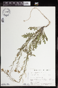 Erucastrum gallicum (Willdenow) O.E. Schultz 732655[1352987]Severson, M. 7151980-08-21 United States, Minnesota, Becker, Zimmerman Prairie: 10 mi. W of Ogema. SE1/4 SW1/4 Sec. 16, T142N, R43W.;Zimmerman Prairie [TNC];142N;43W;16, 47.115026 -96.14142 |
MIN:Plants | 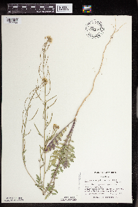 Erucastrum gallicum (Willdenow) O.E. Schultz 741529[1352983]Converse, C. 15051982-07-07 United States, Minnesota, Pope, Ordway Prairie: T123N, R36W, SE1/4 SW1/4 Sec. 19.;Ordway Prairie, The Nature Conservancy;123N;36W;19, 45.448674 -95.245019 |
MIN:Plants | Erucastrum gallicum (Willdenow) O.E. Schultz 753164[]Boe, J. 19921983-07-06 United States, Minnesota, Kittson, Norway Dunes: NE1/4 SE1/4 Sec. 10. Norway Dunes.;Norway Dunes, The Nature Conservancy;160N;46W;10, 48.695736 -96.57277 |
MIN:Plants | Erucastrum gallicum (Willdenow) O.E. Schultz 758471[]Smith, Welby 68041982-07-19 United States, Minnesota, Marshall, Ca. 2 mi. SSW of Holt. NW1/4 SW1/4 Sec. 8, T155N, R43W.;;155N;43W;8, 48.261555 -96.206154 |
MIN:Plants | Erucastrum gallicum (Willdenow) O.E. Schultz 814642[]Wheeler, Gerald 110011988-06-27 United States, Minnesota, Traverse, Ca. 8.5 mi. SW of Wheaton; E of Rte. 27. SW1/4 NE1/4 Sec. 13, T126N, R48W (Windsor Twp.);;126N;48W;13, 45.723544 -96.64617 |
MIN:Plants | 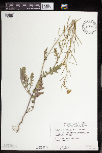 Erucastrum gallicum (Willdenow) O.E. Schultz 815657[1352982]Wheeler, Gerald 120941988-09-09 United States, Minnesota, Wilkin, Ca. 7.7 mi. N of Foxhome; waterfowl area E of Rte. 19. Between a small lake and a road.;Brown Wildlife Management Area;134N;45W;26, 46.391404 -96.312044 |
MIN:Plants | 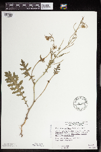 Erucastrum gallicum (Willdenow) O.E. Schultz 815779[1352985]Wheeler, Gerald 107691988-06-17 United States, Minnesota, Norman, Ca. 3.5 mi. NE of Syre; N of Rte. 37. Near gravel pit. SW1/4 SE1/4 Sec. 12, T143N, R44W (Home Lake Twp.);;143N;44W;12, 47.216388 -96.205242 |
MIN:Plants |  Erucastrum gallicum (Willdenow) O.E. Schultz 833841[1352981]Smith, Welby 141701988-06-01 United States, Minnesota, Lac Qui Parle, Lac Qui Parle Co. In the Minnesota Valley, about 6 mi NW of Bellingham. SW1/4 SW1/4 sec 7, T120N R45W;;120N;45W;7, 45.218564 -96.341864 |
MIN:Plants | Erucastrum gallicum (Willdenow) O.E. Schultz 540027[]Tester, John s.n.1957-07-06 United States, Minnesota, Mahnomen, 3-4 miles w. and 1 mile s. of Waubun. ;Waubun Prairie Wildlife Management Area / White Earth Indian Reservation;143N;42W;33, 47.158904 -96.00743 |
MIN:Plants | Erucastrum gallicum (Willdenow) O.E. Schultz 924652[]Cholewa, A. 28192011-07-08 United States, Minnesota, Anoka, Linwood Lake, boat launch.;Martin-Island-Linwood Lakes County Park;033N;22W;09, 45.3575 -93.0972222 |
MIN:Plants |  Erucastrum gallicum (Willdenow) O.E. Schultz 967920[1368415]Drew, L.A. s.n.1971-06-15 United States, Minnesota, Polk, 1.5 miles S Fertile; Agassiz Dunes, 47.503117 -96.30016 |
MIN:Plants | Erysimum arenicola S. Watson 119195[]Piper, C. s.n.1895-08-00 United States, Washington, Olympic Mts. Mt. Stuula [?];Olympic National Park, 2134m |
MIN:Plants | Erysimum arenicola S. Watson 584636[]Morean, Edith 1781962-08-07 United States, Washington, Clallam, Olympic National Park, between Obstruction Point and Hurricane Ridge;Olympic National Park |
MIN:Plants | Boechera pinetorum (Tidestrom) Windham & Al-Shehbaz 597150[]Holmgren, Noel; et al. 20021965-06-22 United States, Utah, Washington, Zion National Park. Washington Co.: Zion National Park, along West Rim Trail of Zion Canyon, south end of Horse Pasture Plateau. T.40S, R.10W, Sec. 33. 040S 10W 33, 2088m |
MIN:Plants |  Alyssum desertorum Stapf 923907[1352087]Cholewa, A. 27882011-05-12 United States, Minnesota, Freeborn, White Fox Campground.;Myre Big Island State Park;102N;21W;13, 43.6338889 -93.3 |
MIN:Plants | Alyssum desertorum Stapf 944931[]Dziuk, Peter M. PMD15-0192015-05-06 United States, Minnesota, Saint Louis, Indian Point Campground. Camp site #44., 46.721547 -92.182903 |
MIN:Plants |  Arabidopsis thaliana (L.) Heynh. 221871[1352088]Dziuk, P.; Chayka, K. PD 10012012-05-10 United States, Minnesota, Pine, .45 miles west of Interstate 35 on County road 70, nursery in drive south side of road. NW1/4 SW1/4 of section;;038N;22W;20, 45.76665 -92.9989444 |
MIN:Plants |  Arabidopsis thaliana (L.) Heynh. 963453[1352004]Nee, M. 629042016-04-27 United States, Wisconsin, Richland, 3.8km E of Gotham; Button Bluff; NE of Button Cemetery along Hwy. JJ, 43.218611 -90.243333, 220m |
MIN:Plants |  Arabidopsis thaliana (L.) Heynh. 971275[1394752]M. H. Nee 655762020-05-24 United States, Wisconsin, Sauk, 4 km NW of center of Spring Green, vic. Spring Green Preserve State Natural Area, western unit on Pearl Road. T 8 N; R 3 E; NW¼NW¼ sect. 1., 43.206111 -90.093333, 225m |
MIN:Plants |  Arabidopsis thaliana (L.) Heynh. 972680[1398233] 152 Norway |
MIN:Plants |  Arabidopsis thaliana (L.) Heynh. 972693[1398246]Janssens, J. 75/171975-04-05 Belgium, Hallerbos, Hendenbroek, 100m |
MIN:Plants | Arabis glabra NULL 933479[]Smith, Welby R. 213671992-08-11 United States, Minnesota, Marshall, On the south side of County Road 108, about 7.5 miles east of Strathcona NE of NW of section;;158N;42W;01, 48.5433333 -96.0097222 |
MIN:Plants | 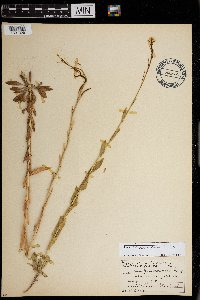 Arabis glabra (L.) Bernh. 0968731[1391329]Manhart, Warren s.n.1938-07-00 United States, Yellowstone Park |
MIN:Plants | 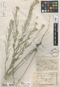 Erysimum syrticolum E. Sheldon 119470[1001124]Sheldon, Edmund 14071891-08-00 United States, Minnesota, Lincoln, Lake Benton;;109N;45W;, 44.241082 -96.261721 |
MIN:Plants | 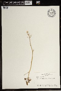 738317[1369672]Hunn, John 441981-03-13 Egypt |
MIN:Plants | 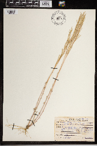 Arabis hirsuta (L.) Scop. 967917[1368418]Drew, L.A. s.n.1969-08-03 United States, Minnesota, Polk, 1.5 miles S Fertile; Agassiz Dunes; T147N R44W sec 32 W 1/2 NE 1/4, 47.507081 -96.291419 |
MIN:Plants |  Arabis hirsuta (L.) Scop. 972694[1398247]Janssens, J. 76/601976-06-06 Belgium, Roche au Bux. IFBL: J5 31 34, 180m |
MIN:Plants |  Pleiocardia fenestrata Greene 121104[1002060]Hall, H.; Chandler, H. 4921900-07-06 United States, California, Fresno, Tehipite Valley, 1219m |
MIN:Plants | 120773[]Sheldon, Edmund S72201893-09-00 United States, Minnesota, Big Stone, Graceville [assuming Big Stone Co. since E.S. collected in the region];;124N;46W;03, 45.579085 -96.421701 |
MIN:Plants | 120926[]Taylor, B. T.10441891-08-00 United States, Minnesota, Pope, Glenwood;;125N;37W;07, 45.650249 -95.376388 |
MIN:Plants | 120928[]Moyer, Lycurgus 17691906-06-26 United States, South Dakota, Roberts, Manhattan Island, Big Stone Lake |
MIN:Plants | 120929[]Sheldon, Edmund 17691891-08-00 United States, Minnesota, Lincoln, Lake Benton. Lincoln Co.;;109N;45W;00, 44.241082 -96.261721 |
MIN:Plants | 120977[]Sheldon, Edmund S14061891-08-00 United States, Minnesota, Lincoln, Lake Benton;;109N;45W;, 44.241082 -96.261721 |
MIN:Plants | Noccaea fendleri subsp. glauca (A. Nelson) Al-Shehbaz & M. Koch 523335[]Cooper, William s.n.1904-08-12 United States, Colorado, Larimer, Mummy Mts, Estes Park;Rocky Mountain National Park, 152m |
MIN:Plants | Lepidium virginicum subsp. menziesii (de Candolle) Thellung 119899[]Elmer, A.D.E. 26971900-06-00 United States, Washington, Clallam, Olympic Mts. [Olympic National Park], 47.83 -123.83 |
MIN:Plants | Lepidium virginicum subsp. menziesii (de Candolle) Thellung 119888[]Burglehaus, F. s.n.1894-07-27 United States, Wyoming, Park, Yellowstone Park...near Mammoth Hot Springs;Yellowstone National Park, 2134m |
MIN:Plants | 921158[]Smith, Welby 236111993-08-13 United States, Minnesota, Kandiyohi, About 3.5 miles northwest of New London. NE1/4 of SW1/4 of section;;122N;33W;31, 45.3313889 -94.8797222 |
MIN:Plants | Arabidopsis lyrata subsp. kamchatica (Fischer ex de Candolle) O’Kane & Al-Shehbaz 548471[]Spetzman, L. 38931951-07-15 United States, Alaska, Arctic North Slope...Canning R. & Ignek Cr.;Arctic National Wildlife Refuge;;;, 69.5833333 -146.25, 305m |
MIN:Plants | Arabidopsis lyrata subsp. kamchatica (Fischer ex de Candolle) O’Kane & Al-Shehbaz 529990[]Hardy, Robert 1901945-07-12 United States, Alaska, Aleutians...Attu Is. ...Boone Creek, Sidden's Valley;Aleutian Islands Wilderness;;;, 52.9 172.9, 274m |
MIN:Plants | Arabidopsis lyrata subsp. kamchatica (Fischer ex de Candolle) O’Kane & Al-Shehbaz 690121[]Glaser, Paul 7751975-06-18 United States, Alaska, Mt. McKinley National Park...NW1/4Sec.4 T14S R9W, vicinity of Morino Grave;Denali National Park, 549m |
MIN:Plants | Arabidopsis lyrata subsp. kamchatica (Fischer ex de Candolle) O’Kane & Al-Shehbaz 690122[]Glaser, Paul 2471972-07-21 United States, Alaska, Mt. McKinley National Park...N1/2Sec.3 T17S R14W, Bergh Lake, Highway Pass;Denali National Park, 1067m |
MIN:Plants | Arabidopsis lyrata subsp. kamchatica (Fischer ex de Candolle) O’Kane & Al-Shehbaz 487863[]Went, F. s.n.1951-09-18 United States, California, Alameda, Livermore, Alameda Co. |
MIN:Plants | Arabidopsis lyrata subsp. kamchatica (Fischer ex de Candolle) O’Kane & Al-Shehbaz 657005[]Noble, Mark; et al. 4801974-08-05 United States, Alaska, Muir Point; from site deglaciated ca. 1880.;Glacier Bay National Park;;;, 58.82694 -136.07722 |
MIN:Plants | Arabidopsis lyrata subsp. kamchatica (Fischer ex de Candolle) O’Kane & Al-Shehbaz 599645[]Cooper, William 271935-07-27 United States, Alaska, Glacier Bay, Station 3;Glacier Bay National Park;;;, 58.797428 -136.838127 |
MIN:Plants | Arabidopsis lyrata subsp. kamchatica (Fischer ex de Candolle) O’Kane & Al-Shehbaz 539745[]Viereck, Les 13501956-07-15 United States, Alaska, Mt. McKinley Nat. Park...Moraine of the Muldrow Glacier adjacent to juction of Glacier Creek and Thoroughfare River;Denali National Park;;;, 63.4 -150.4166667, 914m |
MIN:Plants | Arabidopsis lyrata subsp. kamchatica (Fischer ex de Candolle) O’Kane & Al-Shehbaz 297986[]Mexia, Ynes 20431928-06-25 United States, Alaska, McKinley National Park...Head of Savage River;Denali National Park;;;, 63.918056 -149.495278, 1000m |
MIN:Plants | Arabidopsis lyrata subsp. kamchatica (Fischer ex de Candolle) O’Kane & Al-Shehbaz 599647[]Cooper, William 941935-08-06 United States, Alaska, Glacier Bay, Station 16.;Glacier Bay National Park;;;, 58.878313 -136.06009 |
MIN:Plants | 119846[]Coville, Frederick; et al. 4991891-05-30 United States, California, Inyo, Panamint Mountains. Inyo County;Death Valley National Park, 1740m |
MIN:Plants | 379674[]Hitchcock, C. 61921940-04-26 United States, California, Inyo, West side of Death Valley, Town's Pass...Inyo County;Death Valley National Park, 1524m |
MIN:Plants | 576744[]Shushan, S.; et al. 90351955-05-12 United States, Colorado, Mesa, Mesa Co.: north end of Colorado National Monument, ca. 3 mi. south of Fruita;Colorado National Monument |
MIN:Plants | Descurainia pinnata subsp. pinnata (Walter) Britton 234082[]Congdon, J. s.n.1896-07-07 United States, California, Tuolumne, Hetch-Hetchy Valley, Tuolumne County;Yosemite National Park;;;, 38.06667 -119.9 |
MIN:Plants | Physaria kingii subsp. latifolia (A. Nelson) O'Kane & Al-Shehbaz 597054[]Holmgren, Noel; et al. 19791965-06-22 United States, Utah, Washington, Washington Co.: Zion National Park, Horse Pasture Plateau along West Rim Trail of Zion Canyon. T. 40S, R. 10W, Sec.29;Zion National Park;040S;10W;29, 2225m |
MIN:Plants | Descurainia pinnata subsp. brachycarpa (Richardson) Detling 305016[]Mearns, E. 17571902-07-12 United States, Wyoming, Park, Yellowstone National Park...Mammoth Hot Springs;Yellowstone National Park |
MIN:Plants | Descurainia pinnata subsp. brachycarpa (Richardson) Detling 681036[]Swanson, Steven 6631975-06-18 United States, Wisconsin, La Crosse, Mississippi River (Navigation Pool #8). Site 20, railroad leveel built on an island along a side channel.;Upper Mississippi National Wildlife Refuge |
MIN:Plants | Descurainia pinnata subsp. brachycarpa (Richardson) Detling 392094[]Duncan, W. s.n.1940-05-23 United States, South Dakota, Minnehaha, Sand Hills...Minnehaha Co. |
MIN:Plants | Descurainia pinnata subsp. brachycarpa (Richardson) Detling 681393[]Swanson, Steven 8761975-06-24 United States, Wisconsin, La Crosse, Mississippi River (Navigation Pool #8)...La Crosse Co, Site 27...island along the main channel;Upper Mississippi National Wildlife Refuge |
MIN:Plants | Descurainia pinnata subsp. brachycarpa (Richardson) Detling 120965[]Burglehaus, F. s.n.1894-06-01 United States, Wyoming, Park, Yellowstone Park...near Mammoth Hot Springs;Yellowstone National Park |
Google Map
Google Maps is a web mapping service provided by Google that features a map that users can pan (by dragging the mouse) and zoom (by using the mouse wheel). Collection points are displayed as colored markers that when clicked on, displays the full information for that collection. When multiple species are queried (separated by semi-colons), different colored markers denote each individual species.