University of Minnesota
http://www.umn.edu/
612-625-5000
http://www.umn.edu/
612-625-5000
Minnesota Biodiversity Atlas
Bell Museum
Dataset: MIN-Plants
Taxa: Brassicaceae
Search Criteria: excluding cultivated/captive occurrences
Bell Museum plants | |
 MIN:Plants |  Descurainia pinnata subsp. brachycarpa (Richardson) Detling 520004[1352928]Smith, Welby 210991992-07-23 United States, Minnesota, Le Sueur, Le Sueur Co.; about 1 mi E of Elysian, on the N side of Highway 60. In abandoned gravel pit; Le Sueur Co.; about 1 mi E of Elysian, on the N side of Highway 60. In abandoned gravel pit; T109N R23W SW1/4 of SW1/4 of Sec 31. 109N 23W 31, 44.1983337 -93.6436081 |
MIN:Plants | Descurainia pinnata subsp. brachycarpa (Richardson) Detling 120961[]Holzinger, John s.n.1886-06-00 United States, Minnesota, Winona, Winona Co.;;N;;, 43.926613 -91.67387 |
MIN:Plants | Descurainia pinnata subsp. brachycarpa (Richardson) Detling 120962[]Huntington, A. 1890-06-17 United States, Minnesota, Rock, [no further data];;;;, 43.689864 -96.223907 |
MIN:Plants | Descurainia pinnata subsp. brachycarpa (Richardson) Detling 120963[]Ballard, C. B1361891-06-00 United States, Minnesota, Carver, Chaska;;N;;, 44.789407 -93.602179 |
MIN:Plants | Descurainia pinnata subsp. brachycarpa (Richardson) Detling 120964[]Sandberg, John s.n.1884-00-00 United States, Minnesota, Goodhue, Red Wing;;113N;14W;, 44.555216 -92.495543 |
MIN:Plants | Descurainia pinnata subsp. brachycarpa (Richardson) Detling 120966[]Cheney, L. 1891-06-29 United States, Minnesota, Cook, Grand Marais;North Shore;061N;01E;, 47.777456 -90.325243 |
MIN:Plants | Descurainia pinnata subsp. brachycarpa (Richardson) Detling 120967[]Moyer, Lycurgus s.n1894-06-00 United States, Minnesota, Chippewa, Montevideo;;117N;40W;, 44.934626 -95.675774 |
MIN:Plants | Descurainia pinnata subsp. brachycarpa (Richardson) Detling 120968[]Lakela, Olga 10871935-05-11 United States, Minnesota, Goodhue, Belle Creek bluffs near Welch;Dorer Memorial Hardwood State Forest;N;;, 44.554192 -92.700527 |
MIN:Plants | Descurainia pinnata subsp. brachycarpa (Richardson) Detling 120969[]Sheldon, Edmund 53071891-06-00 United States, Minnesota, Blue Earth, Madison Lake;;109N;25W;, 44.239469 -93.828345 |
MIN:Plants | Descurainia pinnata subsp. brachycarpa (Richardson) Detling 120970[]Herrick, C. 1878-06-00 United States, Minnesota, Hennepin, Minneapolis;;N;;, 44.979965 -93.263836 |
MIN:Plants | Descurainia pinnata subsp. brachycarpa (Richardson) Detling 120971[]Sheldon, Edmund S25061892-06-00 United States, Minnesota, Mille Lacs, Mille Lacs Reservation;;N;;, 46.084999 -93.663298 |
MIN:Plants | Descurainia pinnata subsp. brachycarpa (Richardson) Detling 120972[]Burglehaus, F. s.n.1891-06-19 United States, Minnesota, Hennepin, Minneapolis;;N;;, 44.979965 -93.263836 |
MIN:Plants | Descurainia pinnata subsp. brachycarpa (Richardson) Detling 120973[]Sheldon, Edmund 1895-06-00 United States, Minnesota, Hennepin, Minneapolis;;N;;, 44.979965 -93.263836 |
MIN:Plants | Descurainia pinnata subsp. brachycarpa (Richardson) Detling 120974[]Moyer, Lycurgus s.n.1895-05-10 United States, Minnesota, Chippewa, Montevideo;;117N;40W;, 44.934626 -95.675774 |
MIN:Plants | Descurainia pinnata subsp. brachycarpa (Richardson) Detling 120975[]Moyer, Lycurgus 17681885-06-00 United States, Minnesota, Chippewa, Montevideo;;117N;40W;, 44.934626 -95.675774 |
MIN:Plants | Descurainia pinnata subsp. brachycarpa (Richardson) Detling 120976[]Skinner, S. 1131902-06-16 United States, Minnesota, Jackson, Vicinity of Heron Lake.;;N;;, 43.760874 -95.255356 |
MIN:Plants | Descurainia pinnata subsp. brachycarpa (Richardson) Detling 120978[]Ainslie, G. s.n.1902-05-29 United States, Minnesota, Chester [several townships/villages by this name];;;;, 44.006909 -92.34517 |
MIN:Plants | Descurainia pinnata subsp. brachycarpa (Richardson) Detling 120980[]Moyer, Lycurgus 1893-06-00 United States, Minnesota, Big Stone, R.R. track; Ortonville;;N;;, 45.304687 -96.444779 |
MIN:Plants | Descurainia pinnata subsp. brachycarpa (Richardson) Detling 129979[]Ainslie, G. 17681902-05-08 United States, Minnesota, Olmsted, Mouth of Silver Creek ... Rochester;;;;, 44.028797 -92.448741 |
MIN:Plants | Descurainia pinnata subsp. brachycarpa (Richardson) Detling 263943[]Holzinger, John s.n.1901-07-00 United States, Minnesota, Winona, Wayside, Winona Co.;;N;;, 43.926613 -91.67387 |
MIN:Plants | Descurainia pinnata subsp. brachycarpa (Richardson) Detling 276123[]Moyle, J. 971930-06-29 United States, Minnesota, Clearwater, Itasca Park. At tower. NW1/4 NE1/4 Sec. 1, T143N, R36W.;Itasca State Park;143N;36W;1, 47.232293 -95.180237 |
MIN:Plants | Descurainia pinnata subsp. brachycarpa (Richardson) Detling 281385[]Roberts, Thomas s.n.1878-05-00 United States, Minnesota, Hennepin, Minneapolis;;N;;, 44.979965 -93.263836 |
MIN:Plants |  Descurainia pinnata subsp. brachycarpa (Richardson) Detling 282759[1352931]Myhre, K. 23521992-06-22 United States, Minnesota, Cass, Cass Co.; Located one quarter mile north of the Crow Wing River; along the railroad track; T 133N R 31W NE1/4 of NE1/4 o Cass Co.; Located one quarter mile north of the Crow Wing River; along the railroad track; T 133N R 31W NE1/4 of NE1/4 of Sec 18. 133N 31W 18, 46.332664 -94.640659 |
MIN:Plants | Descurainia pinnata subsp. brachycarpa (Richardson) Detling 289045[]Dahl, A. s.n.1932-06-08 United States, Minnesota, Dakota, Nichols [Nicols], Minnesota bottoms.;Fort Snelling State Park;027N;23W;18, 44.825884 -93.216999 |
MIN:Plants | Descurainia pinnata subsp. brachycarpa (Richardson) Detling 349066[]Rosendahl, C.; et al. 30281935-05-19 United States, Minnesota, Pipestone, Near Pipestone;;106N;46W;, 43.979723 -96.367859 |
MIN:Plants | Descurainia pinnata subsp. brachycarpa (Richardson) Detling 352608[]Nielsen, E. 19801933-05-30 United States, Minnesota, Todd, 2 mi. W of Motley;;N;;, 46.336624 -94.688064 |
MIN:Plants | Descurainia pinnata subsp. brachycarpa (Richardson) Detling 437013[]Moore, John; Hall, Robert 162961944-06-08 United States, Minnesota, Nobles, Along Rock Island right-of-way, 1 mi. N of Worthington.;;N;;, 43.634449 -95.596398 |
MIN:Plants | Descurainia pinnata subsp. brachycarpa (Richardson) Detling 437025[]Moore, John; Hall, Robert 16296a1944-06-08 United States, Minnesota, Nobles, Along Rock Island right-of-way, 1 mi. N of Worthington.;;N;;, 43.634449 -95.596398 |
MIN:Plants | Descurainia pinnata subsp. brachycarpa (Richardson) Detling 503076[]Moore, John 205251950-06-05 United States, Minnesota, Big Stone, Ortonville.;;N;;, 45.304687 -96.444779 |
MIN:Plants | Descurainia pinnata subsp. brachycarpa (Richardson) Detling 507260[]Moore, John 206811950-06-21 United States, Minnesota, Martin, Along the r.r, 1/2 mi. N of Fairmont.;;N;;, 43.652178 -94.461083 |
MIN:Plants | Descurainia pinnata subsp. brachycarpa (Richardson) Detling 528936[]Borchard, Alma s.n.1945-05-21 United States, Minnesota, Blue Earth, Along the r.r. track, NW of Mapleton.;;N;;, 43.928851 -93.956064 |
MIN:Plants | Descurainia pinnata subsp. brachycarpa (Richardson) Detling 550609[]Cotter Tucker, Shirley 40681957-06-07 United States, Minnesota, Polk, East shore of Maple Lake, about 5 miles S of Mentor;;N;;, 47.659239 -96.15975 |
MIN:Plants | Descurainia pinnata subsp. brachycarpa (Richardson) Detling 552154[]Stevens, O. 17181958-05-28 United States, Minnesota, Clay, Moorhead;;N;;, 46.845648 -96.728846 |
MIN:Plants | Descurainia pinnata subsp. brachycarpa (Richardson) Detling 554648[]Moore, John 231581957-06-12 United States, Minnesota, Pipestone, Pipestone Co.; R.R. at Ihlen;;105N;46W;, 43.892618 -96.367453 |
MIN:Plants | Descurainia pinnata subsp. brachycarpa (Richardson) Detling 558263[]Moore, John 236961958-05-25 United States, Minnesota, Blue Earth, 1 mile W of Cambria.;;N;;, 44.238574 -94.334626 |
MIN:Plants | Descurainia pinnata subsp. brachycarpa (Richardson) Detling 560894[]Ownbey, Gerald; Anderson, Henry 28311959-07-12 United States, Minnesota, Clearwater, SW1/4 Sec. 33, T152N, R36W. SW shore of Lower Red Lake.;;152N;33W;36, 47.943303 -95.279531 |
MIN:Plants | Descurainia pinnata subsp. brachycarpa (Richardson) Detling 566730[]Lang, H.; et al. 311878-05-01 United States, Minnesota, Hennepin, Minneapolis;;;;, 44.98 -93.26361 |
MIN:Plants | Descurainia pinnata subsp. brachycarpa (Richardson) Detling 574697[]Moore, John 246341959-06-17 United States, Minnesota, Pipestone, Pipestone Co.; 1 mi. east of Pipestone;;106N;45W;, 43.979365 -96.246045 |
MIN:Plants | Descurainia pinnata subsp. brachycarpa (Richardson) Detling 57805[]Sheldon, Edmund 1895-06-00 United States, Minnesota, Hennepin, Ft. Snelling;Fort Snelling Military Reservation;028N;23W;, 44.905162 -93.166462 |
MIN:Plants | Descurainia pinnata subsp. brachycarpa (Richardson) Detling 585329[]Moore, John 260011962-06-01 United States, Minnesota, Pipestone, Pipestone County...1 mi. northeast of Holland.;;107N;44W;07, 44.088141 -96.174644 |
MIN:Plants | Descurainia pinnata subsp. brachycarpa (Richardson) Detling 585723[]Moore, John 260571962-06-26 United States, Minnesota, Kittson, Growing in vacant lot at Hallock.;;N;;, 48.774426 -96.946447 |
MIN:Plants | Descurainia pinnata subsp. brachycarpa (Richardson) Detling 592130[]Moore, John 265741964-05-20 United States, Minnesota, Houston, Along the r.r, 6 mi. SW of Caledonia.;;N;;, 43.573206 -91.581717 |
MIN:Plants | Descurainia pinnata subsp. brachycarpa (Richardson) Detling 592158[]Moore, John 266191964-05-26 United States, Minnesota, Blue Earth, Growing along the rail road 1 mile W of Mankato.;;N;;, 44.166631 -94.030147 |
MIN:Plants | Descurainia pinnata subsp. brachycarpa (Richardson) Detling 592230[]Westkaemper, Remberta s.n.1964-05-00 United States, Minnesota, Stearns, Stearns Co. St. Joseph.;;124N;29W;, 45.543642 -94.322053 |
MIN:Plants | Descurainia pinnata subsp. brachycarpa (Richardson) Detling 603889[]Moore, John; Moore, Marjorie 271351967-06-10 United States, Minnesota, Pipestone, In the r.r. tracks, E of the Superintendent's house.;Pipestone National Monument;106N;46W;, 43.979723 -96.367859 |
MIN:Plants | Descurainia pinnata subsp. brachycarpa (Richardson) Detling 611378[]Hsi, Yu-tseng [Eugene] 9691969-06-25 United States, Minnesota, Lyon, R.R. track, ca. 3 1/2 mi. S of Marshall on Hwy. 59.;;N;;, 44.39624 -95.75546 |
MIN:Plants |  Descurainia pinnata subsp. brachycarpa (Richardson) Detling 691095[1352934]Sperling, C. 3401976-06-18 United States, Minnesota, Douglas, 3 miles NE of Alexandria. Sandy road ditch along Hwy. 29.;;N;;, 45.915946 -95.333414 |
MIN:Plants |  Descurainia pinnata subsp. brachycarpa (Richardson) Detling 696578[1352933]Smith, Welby 7541978-06-16 United States, Minnesota, Wright, Wright Co.; between Burlington tracks and county 75. T122N R23W N1/2;;122N;25W;32, 45.331907 -93.860001 |
MIN:Plants | 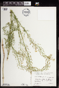 Descurainia pinnata subsp. brachycarpa (Richardson) Detling 700460[1352929]Ownbey, Gerald 59381978-06-18 United States, Minnesota, Cass, Cass Co. T143N, R30W, SW1/4 Sec. 14. Isthmus, just N of S end of Otter Tail Point. E side of isthmus, near boat dock.;Chippewa National Forest / Leech Lake Indian Reservation;143N;30W;14, 47.200075 -94.435208 |
MIN:Plants | 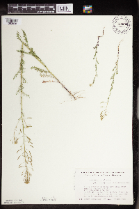 Descurainia pinnata subsp. brachycarpa (Richardson) Detling 743539[1352926]Nietering, E. 671982-05-18 United States, Minnesota, Renville, Renville Co. N of North Redwood. NW1/4 SE1/4 Sec. 20, R35W. At edge of Co. Rd. 15, ca. 1/2 mi. E of intersection with Renville Co. N of North Redwood. NW1/4 SE1/4 Sec. 20, R35W. At edge of Co. Rd. 15, ca. 1/2 mi. E of intersection with Hwy. 1.. 113N 35W 20, 44.578346 -95.085406 |
MIN:Plants | Descurainia pinnata subsp. brachycarpa (Richardson) Detling 745447[]Smith, Welby 38601981-05-19 United States, Minnesota, Mower, Wild Indigo Scientific Natural Area. Mower Co.; Wild Indigo Scientific and Natural Area. About 4 miles southwest of the junction of State Highway 56 and Coun Mower Co.; Wild Indigo Scientific and Natural Area. About 4 miles southwest of the junction of State Highway 56 and County Highway 2 in Brownsdale. NE1/4 NW1/4 section 24, T 103N R 18W. 103N 18W 24, 43.710437 -92.939849 |
MIN:Plants | 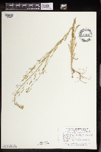 Descurainia pinnata subsp. brachycarpa (Richardson) Detling 745511[1352927]Smith, Welby 38601981-05-19 United States, Minnesota, Mower, Wild Indigo Scientific Natural Area. Wild Indigo Scientific and Natural Area. Ca. 4 mi. SW of the jct. of Hwy. 56 and Co. Hwy. 2 in Brownsdale. NE1/4 NW1/4 Wild Indigo Scientific and Natural Area. Ca. 4 mi. SW of the jct. of Hwy. 56 and Co. Hwy. 2 in Brownsdale. NE1/4 NW1/4 Sec. 24, T103N, R18W.. 103N 18W 24, 43.710437 -92.939849 |
MIN:Plants | Descurainia pinnata subsp. brachycarpa (Richardson) Detling 747471[]Morley, T. 15581983-07-04 United States, Minnesota, Becker, Becker Co. SE end of Many-Point Lake, at Boy Scout bathing beach, ca. 200 ft. N of outlet.;White Earth Indian Reservation;141N;38W;, 47.020447 -95.487655 |
MIN:Plants | 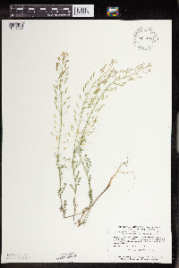 Descurainia pinnata subsp. brachycarpa (Richardson) Detling 801147[1352932]Smith, Welby 102051985-05-28 United States, Minnesota, Jackson, Sangl Wildlife Management Area. Sangle State Wildlife Management Area. On the N side of Hwy. 4, ca. 1/2 mi. E of it's jct. with Hwy. 86. NE1/4 SW1/4 S Sangle State Wildlife Management Area. On the N side of Hwy. 4, ca. 1/2 mi. E of it's jct. with Hwy. 86. NE1/4 SW1/4 Sec. 21, T101N, R36W.. 101N 36W 21, 43.537333 -95.164428 |
MIN:Plants | 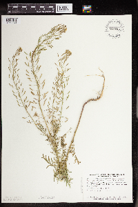 Descurainia pinnata subsp. brachycarpa (Richardson) Detling 801166[1352930]Smith, Welby 102231985-05-28 United States, Minnesota, Jackson, Sioux Valley State Wildlife Management Area, ca. 1 mi. SSE of Sioux Valley. NE1/4 NE1/4 Sec. 29, T101N, R37W.;Sioux Valley Wildlife Management Area;101N;37W;29, 43.522292 -95.304643 |
MIN:Plants | Descurainia pinnata subsp. brachycarpa (Richardson) Detling 120927[]MacMillan, C.; et al. 3631900-08-00 United States, Minnesota, Polk, Crookston;;150N;46W;30, 47.782 -96.60007 |
MIN:Plants | Descurainia pinnata subsp. brachycarpa (Richardson) Detling 916502[]Smith, Welby 223541993-06-08 United States, Minnesota, Carver, Carver County...Carver Park Reserve; about 5 miles west of Chanhassen...T 116N R 24W SE1/4 of NE1/4 of Sec 11;Carver Park Reserve County Park;116N;24W;11, 44.8716667 -93.6644444 |
MIN:Plants | 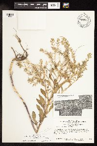 Rorippa palustris subsp. palustris (L.) Besser 681361[1158339]Swanson, Steven 25331976-06-12 United States, Wisconsin, La Crosse, Mississippi River (Navigation Pool #8)...La Crosse Co, Site 7, area on S endge of I-90 levee;Upper Mississippi National Wildlife Refuge |
MIN:Plants | 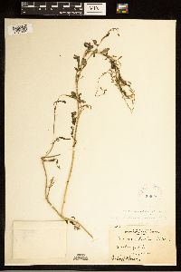 Rorippa palustris subsp. palustris (L.) Besser 268922[1283111]Moore, John 15471924-08-00 United States, South Dakota, Brookings, Brookings;;;;, 44.31139 -96.79806 |
MIN:Plants | 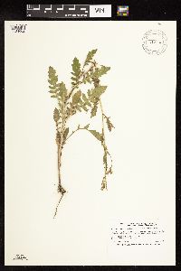 Rorippa palustris subsp. palustris (L.) Besser 912830[1134602]Smith, Welby 243881994-06-14 United States, Minnesota, Yellow Medicine, Upper Sioux Agency State Park. Yellow Medicine County...Upper Sioux Agency State Park; In the Minnesota Valley about seven miles southwest of Sacred Heart...T 115N R 38W SE1/4 of SE1/4 of Sec 29. 115N 38W 29, 44.735 -95.4425 |
MIN:Plants | 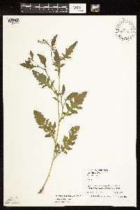 Rorippa palustris subsp. palustris (L.) Besser 493722[1134659]Juhnke, C. 470 CMJ FRO1999-07-23 United States, Minnesota, Goodhue, Frontenac State Park. Goodhue County ... along trail to Sand Point ... T 112N R 13W NE SE NW 13;Frontenac State Park;112N;13W;13, 44.505359 -92.319092 |
MIN:Plants | 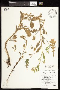 Rorippa palustris subsp. palustris (L.) Besser 447212[1134660]Husveth, J. 96-2801996-07-16 United States, Minnesota, Pine, Pine Co. T42N R17W NE1/4 of the SW1/4 of S36...Graces Lake;Saint Croix State Forest;042N;17W;36, 46.077297 -92.436151 |
MIN:Plants | 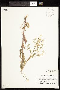 Rorippa palustris subsp. palustris (L.) Besser 460281[1134472]Smith, Welby 210501992-07-20 United States, Minnesota, Redwood, Cedar Rock Wildlife Management Area. Redwood County...In Cedar Rock State Wildlife Management Aarea; about 4 miles north-northwest of Redwood Falls... T 113N R 36W NW1/4 of NW1/4 of sec 11. 113N 36W 11, 44.6122222 -95.1563889 |
MIN:Plants | 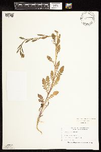 Rorippa palustris subsp. palustris (L.) Besser 504861[1134468]Nation, R. 94-1121994-06-21 United States, Minnesota, Mower, Lake Louise State Park. Mower County...Tract #31N. T101N R14W NE1/4 of SE1/4 of sec.21;Lake Louise State Park;101N;14W;21, 43.536578 -92.519043 |
MIN:Plants | 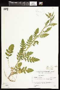 Rorippa palustris subsp. palustris (L.) Besser 518872[1134469]Gerdes, Lynden 23051997-08-11 United States, Minnesota, Aitkin, T50N R22W S06NENW. Aitkin County, MN. Savanna State Park, NE of Savanna Lake along forest trail.;Savanna Portage State Park;050N;22W;06, 46.845996 -93.17745 |
MIN:Plants |  Rorippa palustris subsp. palustris (L.) Besser 120399[1134634]Menzel, Max s.n.1892-06-00 United States, Minnesota, Pipestone, Pipestone [assuming the quarry area; town generally noted as "Pipestone City" by collector];Pipestone National Monument;106N;46W;01, 44.01585 -96.31767 |
MIN:Plants |  Rorippa palustris subsp. palustris (L.) Besser 120405[1134479]Sheldon, Edmund S42191890-06-00 United States, Minnesota, Hennepin, Minneapolis;;N;;, 44.979965 -93.263836 |
MIN:Plants |  Rorippa palustris subsp. palustris (L.) Besser 120521[1134643]Kassube, J. s.n.1878-06-00 United States, Minnesota, Hennepin, Minneapolis;;N;;, 44.979965 -93.263836 |
MIN:Plants | 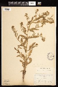 Rorippa palustris subsp. palustris (L.) Besser 120537[1134584]Moyer, Lycurgus s.n.1893-07-07 United States, Minnesota, Chippewa, Rosewood;;118N;40W;, 45.021303 -95.675242 |
MIN:Plants | 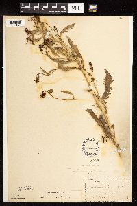 Rorippa palustris subsp. palustris (L.) Besser 120538[1134621]Manning, Sara s.n.1892-07-23 United States, Minnesota, Wabasha, Lake City;;N;;, 44.44402 -92.273367 |
MIN:Plants | 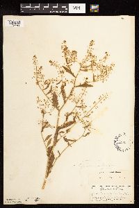 Rorippa palustris subsp. palustris (L.) Besser 120540[1134489]Manning, Sara s.n.1883-07-19 United States, Minnesota, Goodhue, Central Point [pioneer town on Sand Point, Lake Pepin];Frontenac State Park;112N;13W;12, 44.519822 -92.319123 |
MIN:Plants | 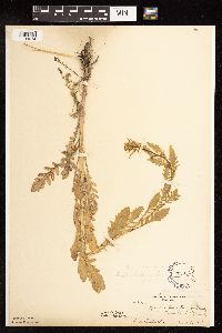 Rorippa palustris subsp. palustris (L.) Besser 120541[1134674]Ballard, C. 28501901-06-05 United States, Minnesota, Clay, Moorhead;;N;;, 46.845648 -96.728846 |
MIN:Plants | 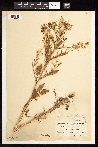 Rorippa palustris subsp. palustris (L.) Besser 120542[1134666]Ainslie, G. 17171902-06-21 United States, Minnesota, Olmsted, S of Rochester;;106N;14W;00, 43.97834 -92.498342 |
MIN:Plants | 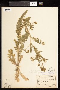 Rorippa palustris subsp. palustris (L.) Besser 120543[1134641]Sandberg, John s.n.1890-06-00 United States, Minnesota, Hennepin, [no further data];;;;, 45 -93.47 |
MIN:Plants | 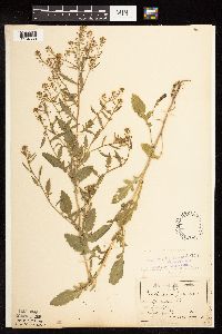 Rorippa palustris subsp. palustris (L.) Besser 120544[1134639]Sandberg, John s.n.1889-07-00 United States, Minnesota, Hennepin, [no further data];;;;, 45 -93.47 |
MIN:Plants | 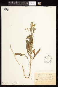 Rorippa palustris subsp. palustris (L.) Besser 120545[1134590]Sheldon, Edmund S13981891-08-00 United States, Minnesota, Lincoln, Lake Benton;;109N;45W;, 44.24108 -96.26172 |
MIN:Plants |  Rorippa palustris subsp. palustris (L.) Besser 120546[1134483]Ballard, C. B6711891-07-00 United States, Minnesota, Carver, Waconia;;116N;25W;, 44.8476 -93.827753 |
MIN:Plants |  Rorippa palustris subsp. palustris (L.) Besser 120547[1134589]Ballard, C. B2661891-06-00 United States, Minnesota, Scott, Jordan, Scott Co.;;114N;23W;, 44.674435 -93.582701 |
MIN:Plants |  Rorippa palustris subsp. palustris (L.) Besser 120548[1134586]Sheldon, Edmund S36531892-08-00 United States, Minnesota, Otter Tail, Fergus Falls;;N;;, 46.283015 -96.077558 |
MIN:Plants |  Rorippa palustris subsp. palustris (L.) Besser 120549[1134588]Sheldon, Edmund S28251892-07-00 United States, Minnesota, Kanabec, Mora, Kanabec Co.;;039N;24W;, 45.860683 -93.327529 |
MIN:Plants | 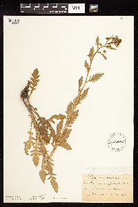 Rorippa palustris subsp. palustris (L.) Besser 120550[1134485]Taylor, B. T3411891-06-00 United States, Minnesota, Waseca, Janesville;;N;;, 44.116078 -93.708004 |
MIN:Plants | 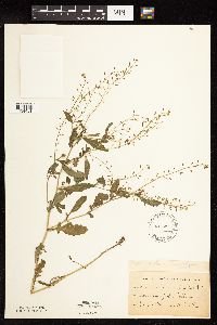 Rorippa palustris subsp. palustris (L.) Besser 120551[1134481]Oestlund, O. s.n.1886-07-00 United States, Minnesota, Hennepin, Minneapolis;;N;;, 44.979965 -93.263836 |
MIN:Plants | 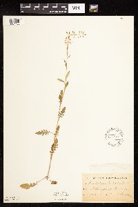 Rorippa palustris subsp. palustris (L.) Besser 120552[1134480]Sheldon, Edmund S10931891-07-00 United States, Minnesota, Brown, Springfield;;N;;, 44.238848 -94.975823 |
MIN:Plants | 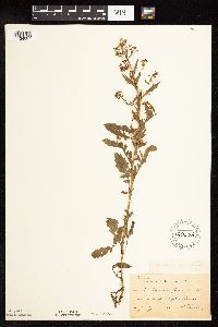 Rorippa palustris subsp. palustris (L.) Besser 120553[1134667]Sheldon, Edmund S7601891-07-00 United States, Minnesota, Brown, Sleepy Eye;;110N;32W;, 44.325885 -94.684758 |
MIN:Plants | 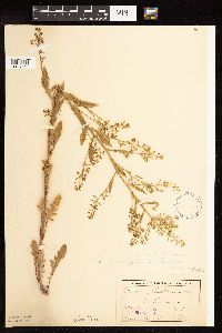 Rorippa palustris subsp. palustris (L.) Besser 120556[1134653]Sheldon, Edmund s.n.1895-06-00 United States, Minnesota, Dakota, Ft. Snelling;;N;;, 44.864295 -93.200794 |
MIN:Plants | 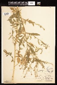 Rorippa palustris subsp. palustris (L.) Besser 120557[1134642]Aiton, G. s.n.1889-07-00 United States, Minnesota, Hennepin, [no further data];;;;, 45 -93.47 |
MIN:Plants | 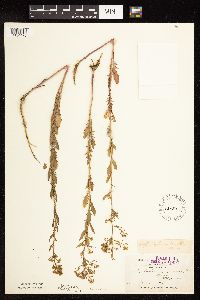 Rorippa palustris subsp. palustris (L.) Besser 120558[1134478]Holzinger, John s.n.1886-06-00 United States, Minnesota, Winona, Winona Co.;;N;;, 43.926613 -91.67387 |
MIN:Plants | 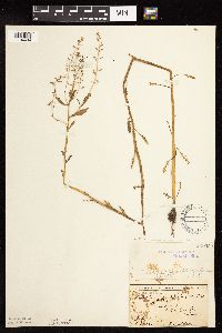 Rorippa palustris subsp. palustris (L.) Besser 120559[1134494]Sheldon, Edmund S32081892-07-00 United States, Minnesota, Mille Lacs, Milaca;;N;;, 45.755204 -93.648713 |
MIN:Plants |  Rorippa palustris subsp. palustris (L.) Besser 120560[1134486]Sandberg, John s.n.1881-06-00 United States, Minnesota, Goodhue, Cannon Falls;;N;;, 44.49989 -92.85476 |
MIN:Plants |  Rorippa palustris subsp. palustris (L.) Besser 120561[1134587]Ballard, C. B9751892-06-00 United States, Minnesota, Nicollet, Nicollet;;109N;28W;, 44.239687 -94.190492 |
MIN:Plants |  Rorippa palustris subsp. palustris (L.) Besser 120562[1134619]Menzel, Max s.n.1895-06-00 United States, Minnesota, Pipestone, Pipestone [assuming the quarry area; town generally noted as "Pipestone City" by collector];Pipestone National Monument;106N;46W;01, 44.01585 -96.31767 |
MIN:Plants |  Rorippa palustris subsp. palustris (L.) Besser 120563[1134679]Lyon, H. 2001899-07-07 United States, Minnesota, Houston, Crooked Creek, Houston Co.;Dorer Memorial Hardwood State Forest;N;;, 43.604456 -91.373075 |
MIN:Plants | 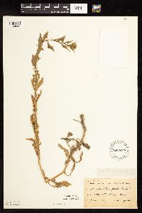 Rorippa palustris subsp. palustris (L.) Besser 120564[1134669]Taylor, B. T13281892-06-00 United States, Minnesota, Chisago, Center City;;034N;20W;, 45.42608 -92.83619 |
MIN:Plants | 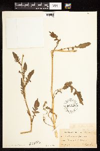 Rorippa palustris subsp. palustris (L.) Besser 120565[1134592]Herrick, C. s.n.1884-07-03 United States, Minnesota, Carlton, St. Louis River [assuming near Duluth];;048N;15W;00, 46.783273 -92.106579 |
MIN:Plants | 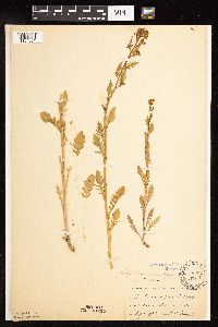 Rorippa palustris subsp. palustris (L.) Besser 120566[1134681]Moyer, Lycurgus s.n.1891-05-00 United States, Minnesota, Chippewa, Montevideo;;117N;40W;, 44.934626 -95.675774 |
MIN:Plants | 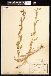 Rorippa palustris subsp. palustris (L.) Besser 120567[1134678]Ballard, C. B14151893-06-00 United States, Minnesota, Cass, Lake Kilpatrick;;135N;29W;, 46.500163 -94.32908 |
MIN:Plants | 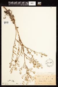 Rorippa palustris subsp. palustris (L.) Besser 120568[1134615]Ballard, C. B3261891-06-00 United States, Minnesota, Scott, Belle Plaine;;N;;, 44.622741 -93.768573 |
MIN:Plants | 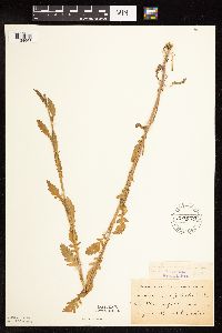 Rorippa palustris subsp. palustris (L.) Besser 120570[1134668]Herrick, C. s.n.1878-06-00 United States, Minnesota, Hennepin, Minneapolis;;N;;, 44.979965 -93.263836 |
MIN:Plants | 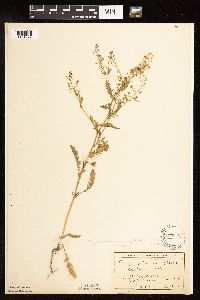 Rorippa palustris subsp. palustris (L.) Besser 120573[1134677]MacMillan, C.; et al. 2141900-08-00 United States, Minnesota, Polk, Crookston;;150N;46W;30, 47.77414 -96.60812 |
MIN:Plants | 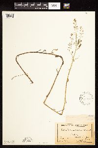 Rorippa palustris subsp. palustris (L.) Besser 120574[1134604]Sheldon, Edmund S.32081892-07-00 United States, Minnesota, Mille Lacs, Milaca, Mille Lacs Co.;;038N;27W;25, 45.756966 -93.647572 |
Google Map
Google Maps is a web mapping service provided by Google that features a map that users can pan (by dragging the mouse) and zoom (by using the mouse wheel). Collection points are displayed as colored markers that when clicked on, displays the full information for that collection. When multiple species are queried (separated by semi-colons), different colored markers denote each individual species.