University of Minnesota
http://www.umn.edu/
612-625-5000
http://www.umn.edu/
612-625-5000
Minnesota Biodiversity Atlas
Bell Museum
Dataset: MIN-Plants
Taxa: Brassicaceae
Search Criteria: excluding cultivated/captive occurrences
Bell Museum plants | |
 MIN:Plants |  Rorippa palustris subsp. palustris (L.) Besser 120630[1134638]Menzel, Max s.n.1895-06-00 United States, Minnesota, Pipestone, Pipestone [assuming the quarry area; town generally noted as "Pipestone City" by collector];Pipestone National Monument;106N;46W;01, 44.01585 -96.31767 |
MIN:Plants |  Rorippa palustris subsp. palustris (L.) Besser 129555[1134491]Taylor, B. T8621891-07-00 United States, Minnesota, Pope, Glenwood;;N;;, 45.65 -95.365833 |
MIN:Plants |  Rorippa palustris subsp. palustris (L.) Besser 263948[1134613]Holzinger, John s.n.1901-06-00 United States, Minnesota, Winona, Lake Winona, Winona Co.;;107N;07W;, 44.052588 -91.672687 |
MIN:Plants |  Rorippa palustris subsp. palustris (L.) Besser 276122[1134652]Grant, Martin 33131929-09-13 United States, Minnesota, Clearwater, Itasca Park. N of park. NW1/4 SW1/4 Sec. 16, T144N, R36W.;Itasca State Park;144N;36W;16, 47.28952 -95.243405 |
MIN:Plants |  Rorippa palustris subsp. palustris (L.) Besser 277780[1134614]Roberts, Thomas s.n.1878-06-00 United States, Minnesota, Hennepin, Minneapolis;;N;;, 44.979965 -93.263836 |
MIN:Plants |  Rorippa palustris subsp. palustris (L.) Besser 281392[1134676]Roberts, Thomas s.n1884-07-30 United States, Minnesota, Chisago, Taylors Falls;;N;;, 45.401906 -92.652429 |
MIN:Plants |  Rorippa palustris subsp. palustris (L.) Besser 289644[1134673]Moyle, J. 9181933-07-18 United States, Minnesota, Becker, Itasca Park. Twin Island Lake. SW1/4 SW1/4 Sec. 5, T142N, R36W.;Itasca State Park;142N;36W;5, 47.144933 -95.265368 |
MIN:Plants |  Rorippa palustris subsp. palustris (L.) Besser 332631[1134651]Grant, Martin 66701935-08-21 United States, Minnesota, Clearwater, South boundary of Itasca Park. SE1/4 SE1/4 Sec. 1, T142N, R36.;Itasca State Park;143N;36W;1, 47.232293 -95.180237 |
MIN:Plants | 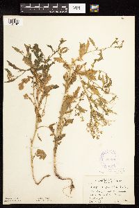 Rorippa palustris subsp. palustris (L.) Besser 338345[1134487]Rosendahl, C.; Moyle, J. 21871936-07-18 United States, Minnesota, Lake of the Woods, 16 mi. S of Baudette.;;N;;, 48.480924 -94.59993 |
MIN:Plants | 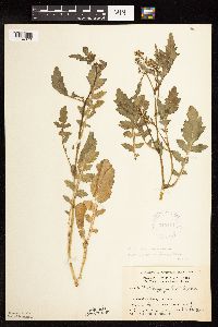 Rorippa palustris subsp. palustris (L.) Besser 345414[1134670]Grant, Martin 68101936-08-21 United States, Minnesota, Becker, Itasca Park. Becker Co. De Soto Lake. NW1/4 NE1/4 Sec. 3, T142N, R36W.;Itasca State Park;142N;36W;3, 47.145259 -95.222785 |
MIN:Plants | Rorippa palustris subsp. palustris (L.) Besser 347612[]Grdgr, C. s.n. United States, Minnesota, [no further data];;;;, 46 -94 |
MIN:Plants | 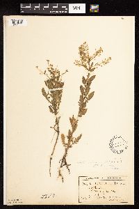 Rorippa palustris subsp. palustris (L.) Besser 349638[1134680]Ballard, C. 27091900-08-00 United States, Minnesota, Kittson, Northcote;;162N;49W;, 48.84732 -96.99641 |
MIN:Plants | 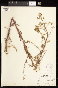 Rorippa palustris subsp. palustris (L.) Besser 356622[1134654]Lakela, Olga 31571939-07-15 United States, Minnesota, Saint Louis, Lake Superior, 14 mi. N of Duluth.;North Shore;;;, 46.985947 -92.106579 |
MIN:Plants |  Rorippa palustris subsp. palustris (L.) Besser 356626[1134648]Lakela, Olga 33591939-09-16 United States, Minnesota, Saint Louis, Superior Bay, near the recreation grounds, Minnesota Point, Duluth.;Minnesota Point;049N;13W;18, 46.741215 -92.062388 |
MIN:Plants |  Rorippa palustris subsp. palustris (L.) Besser 357935[1134488]Rosendahl, C. 6371902-06-30 United States, Minnesota, Houston, Spring Grove;;101N;07W;, 43.543923 -91.6707 |
MIN:Plants |  Rorippa palustris subsp. palustris (L.) Besser 361776[1134490]Horton, E. s.n.1936-08-04 United States, Minnesota, Saint Louis, Minnesota Point.;Minnesota Point;049N;13W;18, 46.741215 -92.062388 |
MIN:Plants |  Rorippa palustris subsp. palustris (L.) Besser 362795[1134484]Butters, F.; Moore, John 136101940-09-18 United States, Minnesota, Chisago, Near roadside; 5 mi. E of Sunrise.;;N;;, 45.546858 -92.751557 |
MIN:Plants |  Rorippa palustris subsp. palustris (L.) Besser 362927[1134644]Moyle, J. 35521940-07-04 United States, Minnesota, Saint Louis, near Rice L.;;N;;, 46.902946 -92.105192 |
MIN:Plants |  Rorippa palustris subsp. palustris (L.) Besser 364711[1134591]Moyle, J. 36051940-10-10 United States, Minnesota, Koochiching, Koochiching Co.; Along Rainy Lake. Along Rainy Lake.. , 48.566517 -93.196011 |
MIN:Plants |  Rorippa palustris subsp. palustris (L.) Besser 364995[1134636]Roberts, Thomas s.n.1925-07-22 United States, Minnesota, Saint Louis, Crab Lake Trail, Burntside Lake.;Superior National Forest;063N;13W;19, 47.924109 -92.041528 |
MIN:Plants |  Rorippa palustris subsp. palustris (L.) Besser 368866[1134628]Lakela, Olga 48681941-09-05 United States, Minnesota, Carlton, S of Cloquet.;;N;;, 46.72161 -92.459357 |
MIN:Plants |  Rorippa palustris subsp. palustris (L.) Besser 375193[1134632]Lakela, Olga 51391942-08-13 United States, Minnesota, Saint Louis, Deep Lake, Sparta.;;058N;17W;, 47.502874 -92.49693 |
MIN:Plants |  Rorippa palustris subsp. palustris (L.) Besser 385500[1134585]Rosendahl, C. 77421945-09-15 United States, Minnesota, Houston, East Beaver Spring, Sec.17 Caledonia Twp.;Beaver Creek Valley State Park;102N;06W;17, 43.637879 -91.581102 |
MIN:Plants |  Rorippa palustris subsp. palustris (L.) Besser 392907[1134610]Lakela, Olga 64531946-06-26 United States, Minnesota, Saint Louis, Sand Bar Island in Duluth Harbor, Duluth.;;N;;, 46.750055 -92.078301 |
MIN:Plants |  Rorippa palustris subsp. palustris (L.) Besser 394090[1134596]Butters, F.; Moore, John 108601939-07-03 United States, Minnesota, Cook, Ca. 6 in. above the water line, S of John Lake. T65N, R3E.;Boundary Waters Canoe Area Wilderness / Superior National Forest;065N;03E;, 48.081607 -90.076407 |
MIN:Plants |  Rorippa palustris subsp. palustris (L.) Besser 394091[1134627]Rosendahl, C.; Butters, F. 69141937-08-28 United States, Minnesota, Cook, At the mouth of the Cascade River. Cook Co.;Cascade River State Park / North Shore;060N;02E;, 47.70799 -90.52361 |
MIN:Plants |  Rorippa palustris subsp. palustris (L.) Besser 394145[1134593]Butters, F.; Abbe, E. 8531944-08-02 United States, Minnesota, Cook, Near the beginning of Lima Mt. T64N, R01W.;Superior National Forest;064N;01W;, 48.019271 -90.447457 |
MIN:Plants |  Rorippa palustris subsp. palustris (L.) Besser 406353[1134633]Jones, George Neville 180041946-07-05 United States, Minnesota, Saint Louis, Armstrong Lake, near Ely.;;062N;14W;, 47.844609 -92.115349 |
MIN:Plants |  Rorippa palustris subsp. palustris (L.) Besser 412566[1134630]Moore, John; Moore, Marjorie 111661939-07-26 United States, Minnesota, Lake of the Woods, E bank of Pine Creek, Angle Inlet.;Northwest Angle;168N;34W;, 49.344621 -95.028893 |
MIN:Plants | 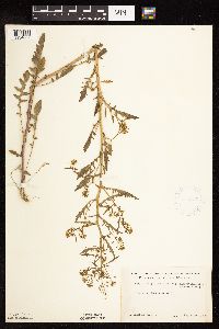 Rorippa palustris subsp. palustris (L.) Besser 418935[1134607]Ahlgren, Clifford 4131949-08-31 United States, Minnesota, Lake, Quetico-Superior Wilderness Research Center...Lake Co, Sec. 9, T64N, R10W.;Boundary Waters Canoe Area Wilderness / Superior National Forest;064N;10W;09, 48.03165 -91.61886 |
MIN:Plants | 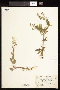 Rorippa palustris subsp. palustris (L.) Besser 419307[1134594]Briggs, John De Q.; Briggs, Marjorie 901945-08-06 United States, Minnesota, Cook, Near Sawbill Lodge, Sawbill Trail. T62N, R4W.;Superior National Forest;062N;04W;, 47.845796 -90.829882 |
MIN:Plants | 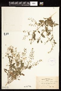 Rorippa palustris subsp. palustris (L.) Besser 422613[1134608]Lakela, Olga 77451948-08-22 United States, Minnesota, Saint Louis, Island Lake, 20 mi. N of Duluth.;;053N;14W;, 47.068211 -92.111778 |
MIN:Plants | 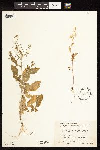 Rorippa palustris subsp. palustris (L.) Besser 442113[1134609]Moore, John; Huff, N. 190971946-08-17 United States, Minnesota, Swift, City park at Benson. Swift Co.;;121N;39W;, 45.281782 -95.562316 |
MIN:Plants | 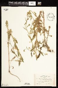 Rorippa palustris subsp. palustris (L.) Besser 443015[1134672]Lakela, Olga 130151951-07-10 United States, Minnesota, Saint Louis, Shore of Namakan Lake near Kettle Falls.;Voyageurs National Park;N;;, 48.502683 -92.639596 |
MIN:Plants | 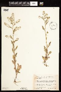 Rorippa palustris subsp. palustris (L.) Besser 445916[1134612]Moore, John; Huff, N. 180051945-07-26 United States, Minnesota, Morrison, Along the shore of Twin Lakes, 5 mi. W of Little Falls.;;N;;, 45.985098 -94.482478 |
MIN:Plants | 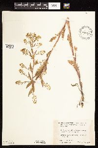 Rorippa palustris subsp. palustris (L.) Besser 448393[1134611]Moore, John; et al. 176931945-07-10 United States, Minnesota, Martin, 1 mi. W of Farimont.;;;;, 43.652178 -94.461083 |
MIN:Plants | 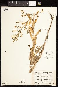 Rorippa palustris subsp. palustris (L.) Besser 448814[1134622]Moore, John; et al. 176571945-07-10 United States, Minnesota, Jackson, Along the stream bank at Sioux Valley.;;;;, 43.543852 -95.304721 |
MIN:Plants |  Rorippa palustris subsp. palustris (L.) Besser 500675[1134631]Harris, S. 4131953-09-24 United States, Minnesota, Marshall, Middle CCC Pool, Mud Lake National Wildlife Refuge.;Agassiz National Wildlife Refuge;N;;, 48.339325 -95.949772 |
MIN:Plants |  Rorippa palustris subsp. palustris (L.) Besser 507366[1134629]Moore, John 209411950-09-28 United States, Minnesota, Murray, Along the shore of South Badger Lake.;;N;;, 43.916539 -95.729901 |
MIN:Plants |  Rorippa palustris subsp. palustris (L.) Besser 527929[1134649]Fallstad, R.; et al. s.n.1955-07-07 United States, Minnesota, Lincoln, Gislason Lake. T111N, R44W, Sec. 1.;;111N;44W;01, 44.451786 -96.089928 |
MIN:Plants |  Rorippa palustris subsp. palustris (L.) Besser 532510[1134623]Lakela, Olga 202091956-07-01 United States, Minnesota, Saint Louis, Willow River, Hwy. 5 S of Greaney. Willow Valley W of Gheen.;;063N;20W;00, 47.935663 -92.892823 |
MIN:Plants |  Rorippa palustris subsp. palustris (L.) Besser 542690[1134583]Moore, John 217951954-07-19 United States, Minnesota, Wilkin, along the Otter Tail River at Breckenridge.;;N;;, 46.271139 -96.582185 |
MIN:Plants |  Rorippa palustris subsp. palustris (L.) Besser 550007[1134482]Moore, John; et al. 222831954-09-22 United States, Minnesota, Lincoln, Lincoln County...Sec. 23, Marshfield Twp. ca. 2 1/2 mi. NE of Tyler;;110N;44W;23, 44.320313 -96.109568 |
MIN:Plants |  Rorippa palustris subsp. palustris (L.) Besser 551349[1134620]Cotter Tucker, Shirley 38331954-09-18 United States, Minnesota, Polk, 2 mi. N of Crookston.;;N;;, 47.803087 -96.608121 |
MIN:Plants |  Rorippa palustris subsp. palustris (L.) Besser 554457[1134671]Moore, John; Hsi, Yu-tseng [Eugene] 233121957-08-05 United States, Minnesota, Blue Earth, Along the N shore of Ballantyne Lake.;;109N;25W;, 44.239469 -93.828345 |
MIN:Plants |  Rorippa palustris subsp. palustris (L.) Besser 566612[1134625]Moore, John; Bernardini, J. 243171958-09-19 United States, Minnesota, Blue Earth, Along the Blue Earth River, 1 mi. S of Mankato.;;;;, 44.14876 -94.032573 |
MIN:Plants |  Rorippa palustris subsp. palustris (L.) Besser 572526[1134650]Moore, John 256781961-07-29 United States, Minnesota, Isanti, Near old barn on west boundary road, 1/2 mi. S of the NW corner of Cedar Creek Natural History Area.;Cedar Creek National History Area;034N;23W;, 45.428063 -93.203997 |
MIN:Plants |  Rorippa palustris subsp. palustris (L.) Besser 578633[1134624]Ownbey, Gerald 33401962-08-17 United States, Minnesota, Clearwater, Itasca State Park. Gravel pit across hwy. from Biological Station. T143N, R36W, SW1/4 Sec. 1.;Itasca State Park;143N;36W;1, 47.232293 -95.180237 |
MIN:Plants |  Rorippa palustris subsp. palustris (L.) Besser 583872[1134598]Gunderson, R. 3291961-07-03 United States, Minnesota, Washington, Washington County ... St. Croix River 3 mi N of Stillwater.;Saint Croix National Riverway;030N;20W;, 45.084979 -92.817348 |
MIN:Plants | 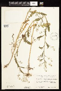 Rorippa palustris subsp. palustris (L.) Besser 583995[1134597]Gunderson, R. 3371961-07-03 United States, Minnesota, Washington, Washington County ... St. Croix River, 3 mi. N Stillwater.;Saint Croix National Riverway;030N;20W;, 45.084979 -92.817348 |
MIN:Plants | 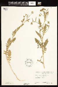 Rorippa palustris subsp. palustris (L.) Besser 592354[1134626]Westkaemper, Remberta s.n.1964-06-00 United States, Minnesota, Stearns, Stearns Co. St. Joseph;;124N;29W;, 45.543642 -94.322053 |
MIN:Plants | 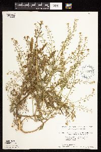 Rorippa palustris subsp. palustris (L.) Besser 616668[1134640]Moore, John; Moore, Marjorie 2481969-07-02 United States, Minnesota, Crow Wing, Crow Wing Natural History Area. Growing along the E line of the NW1/4 , Sec.20, Garrison Twp.;Crow Wing Natural Area;044N;28W;20, 46.279654 -93.90513 |
MIN:Plants | 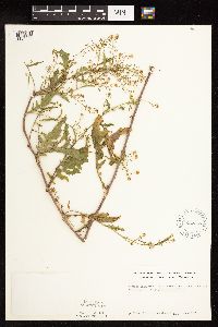 Rorippa palustris subsp. palustris (L.) Besser 622257[1134595]Westkaemper, Remberta s.n.1967-06-00 United States, Minnesota, Stearns, Stearns Co. St. Joseph;;124N;29W;, 45.543642 -94.322053 |
MIN:Plants |  Rorippa palustris subsp. palustris (L.) Besser 670609[1134675]Heitlinger, M. 2851971-07-11 United States, Minnesota, McLeod, Schaefer Prairie: SE1/4 Sec. 34, T115N, R29W;Schaefer Prairie, The Nature Conservancy;115N;29W;34, 44.72505 -94.30491 |
MIN:Plants |  Rorippa palustris subsp. palustris (L.) Besser 681234[1134664]Swanson, Steven 7861975-06-23 United States, Minnesota, Houston, Mississippi River (Navigation Pool #8). Houston Co, Site 26, N tip of Pettibone Island.;Upper Mississippi National Wildlife Refuge;N;;, 43.763684 -91.282376 |
MIN:Plants |  Rorippa palustris subsp. palustris (L.) Besser 681516[1134665]Swanson, Steven 8941975-06-25 United States, Minnesota, Houston, Mississippi River (Navigation Pool #8). Houston Co, Site 28. To the W of r.r. levee.;Upper Mississippi National Wildlife Refuge;N;;, 43.763684 -91.282376 |
MIN:Plants |  Rorippa palustris subsp. palustris (L.) Besser 687178[1134492]Wheeler, Gerald; Glaser, Paul 16061977-06-05 United States, Minnesota, Itasca, Site 46. SW1/4 SW1/4 Sec. 36, T57N, R27W; ca. 12.5 mi. NW of Grand Rapids.;;057N;27W;36, 47.378588 -93.719761 |
MIN:Plants |  Rorippa palustris subsp. palustris (L.) Besser 687329[1134493]Wheeler, Gerald; Glaser, Paul 17581977-06-27 United States, Minnesota, Itasca, Site 67. NE1/4 SE1/4 Sec. 21, T55N, R25W. Grand Rapids. Directly under the bridge where Hwy. 169 crosses the Mississi Site 67. NE1/4 SE1/4 Sec. 21, T55N, R25W. Grand Rapids. Directly under the bridge where Hwy. 169 crosses the Mississippi River in Grand Rapids.. 055N 25W 21, 47.231866 -93.522768 |
MIN:Plants |  Rorippa palustris subsp. palustris (L.) Besser 695807[1134645]Clemants, Steven 9151977-09-16 United States, Minnesota, Crow Wing, W shore of Cross Lake.;;137N;27W;30, 46.653138 -94.145909 |
MIN:Plants |  Rorippa palustris subsp. palustris (L.) Besser 695868[1134647]Clemants, Steven 9891977-10-09 United States, Minnesota, Crow Wing, Pelican Lake, Sunset Beach. 13 mi. N of Brainerd. Sec. 35 & 36, T136N, R28W.;;136N;28W;, 46.588001 -94.204156 |
MIN:Plants |  Rorippa palustris subsp. palustris (L.) Besser 696550[1134646]Smith, Welby 7631978-07-15 United States, Minnesota, Wright, Wright Co.; T122N, R26W, N1/2 Sec. 7. About 2 mi. SE of Clearwater. On the Mississippi River.;;122N;26W;7, 45.390467 -94.00344 |
MIN:Plants | 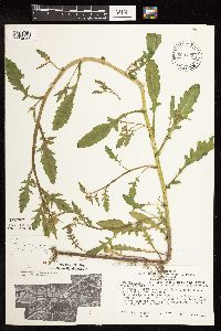 Rorippa palustris subsp. palustris (L.) Besser 699745[1134658]Ziegler, S.; et al. 12331975-06-16 United States, Minnesota, Houston, Houston Co, Island 14; Mississippi River mile #691.6; T103N, R4W, Sec. 13...Small site W of main channel;Upper Mississippi National Wildlife Refuge;103N;04W;13, 43.725044 -91.265964 |
MIN:Plants | 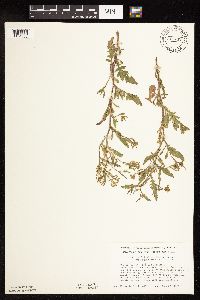 Rorippa palustris subsp. palustris (L.) Besser 711442[1134605]Smith, Welby 10271979-06-27 United States, Minnesota, Pipestone, T106N, R46W, SE1/4 SW1/4 Sec. 1. Pipestone National Monument. Ca. 200 ft. W of the E boundary.;Pipestone National Monument;106N;46W;1, 44.015848 -96.317669 |
MIN:Plants | 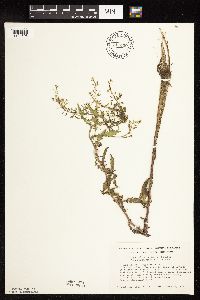 Rorippa palustris subsp. palustris (L.) Besser 711450[1134606]Smith, Welby 10381979-06-27 United States, Minnesota, Rock, T103N, R45W, SW1/4 Sec. 25. Blue Mounds State Park, 3 mi. N of Luverne.;Blue Mounds State Park;103N;45W;25, 43.695974 -96.182724 |
MIN:Plants | 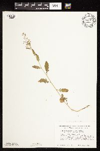 Rorippa palustris subsp. palustris (L.) Besser 724265[1134637]Smith, Welby 31031980-08-01 United States, Minnesota, Wright, Wright Co.; T119N, R24W, SE1/4 SE1/4, Sec. 20. Between the Crow River and Co. Rd. 19, about 1/2 mi. NE of its jct. with Wright Co.; T119N, R24W, SE1/4 SE1/4, Sec. 20. Between the Crow River and Co. Rd. 19, about 1/2 mi. NE of its jct. with Hwy. 55 in Rockford.. 119N 24W 20, 45.080368 -93.740949 |
MIN:Plants | 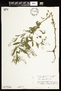 Rorippa palustris subsp. palustris (L.) Besser 726435[1134471]Smith, Welby 31031980-08-01 United States, Minnesota, Wright, Wright Co.; T119N, R24W, SE1/4 SE1/4 Sec. 20. Between the Crow River and Co. Rd. 19, ca. 1/2 mi. NE of Rockford.;;119N;24W;20, 45.096081 -93.728422 |
MIN:Plants | 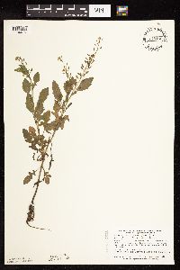 Rorippa palustris subsp. palustris (L.) Besser 745150[1134475]Smith, Welby 56441981-09-02 United States, Minnesota, Dodge, Dodge Co. About 2 mi S of Hayfield and 100 m N of the Mower-Dodge Co. line. Strip between Hwy. 56 and the Chicago and N Dodge Co. About 2 mi S of Hayfield and 100 m N of the Mower-Dodge Co. line. Strip between Hwy. 56 and the Chicago and Northwestern R.R. tracks. SE1/4 SE1/4 Sec. 33, T105N, R17W.. 105N 17W 33, 43.855991 -92.869084 |
MIN:Plants | 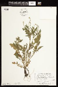 Rorippa palustris subsp. palustris (L.) Besser 759059[1134474]Smith, Welby 75791982-09-08 United States, Minnesota, Mower, Cartney Wildlife Management Area. Cartney State Wildlife Management Area, ca. 5 mi. NNW of Le Roy. West Branch Little Iowa River. NW1/4 NE1/4 Sec. 5, T1 Cartney State Wildlife Management Area, ca. 5 mi. NNW of Le Roy. West Branch Little Iowa River. NW1/4 NE1/4 Sec. 5, T101N, R14W.. 101N 14W 5, 43.580048 -92.539234 |
MIN:Plants | 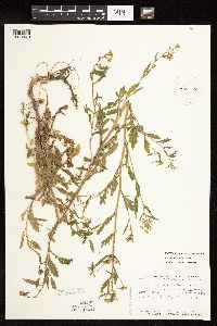 Rorippa palustris subsp. palustris (L.) Besser 787636[1134470]Smith, Welby 106591985-07-11 United States, Minnesota, Goodhue, Goodhue County...sandbar in the Cannon River, about 2.5 mi. E of Welch. SW1/4 SW1/4 Sec. 25, T113N, R16W.;Dorer Memorial Hardwood State Forest;113N;16W;25, 44.564651 -92.562251 |
MIN:Plants | 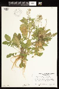 Rorippa palustris subsp. palustris (L.) Besser 793142[1134476]Ownbey, Gerald 72461987-10-09 United States, Minnesota, Goodhue, T112N, R12W, Sec. 32, NW1/4. Lake Pepin in city park just N of Lake City.;;112N;12W;32, 44.461862 -92.279073 |
MIN:Plants | 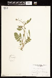 Rorippa palustris subsp. palustris (L.) Besser 796477[1134635]Engels, A. s.n.1988-07-15 United States, Minnesota, Aitkin, Aitkin Co. Engels'(Sanford) Farm, Hwy. 69, ca. 2 mi. SW of Palisade. T49N, R25W, Sec. 33, NW1/4. Along riverbank of Mi Aitkin Co. Engels'(Sanford) Farm, Hwy. 69, ca. 2 mi. SW of Palisade. T49N, R25W, Sec. 33, NW1/4. Along riverbank of Mississippi.. 049N 25W 33, 46.688685 -93.516311 |
MIN:Plants | 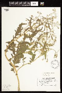 Rorippa palustris subsp. palustris (L.) Besser 508411[1134477]Smith, Welby 170951990-06-27 United States, Minnesota, Martin, Martin County...Island State Wildlife Management Area, about 4 mi SW of Fairmont...T102N R31W SE1/4 of SE1/4 of Sec 29;Island Wildlife Management Area;102N;31W;29, 43.6047222 -94.5736111 |
MIN:Plants | 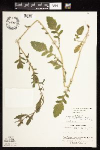 Rorippa palustris subsp. palustris (L.) Besser 746855[1134663]Lee, Craig 381982-06-29 United States, Minnesota, Kandiyohi, Kandiyohi County ... Regal Meadow: T122N R33W NE1/4 SE1/4 of Sec. 16;Regal Meadow, The Nature Conservancy;122N;33W;16, 45.376922 -94.835116 |
MIN:Plants |  Rorippa palustris subsp. palustris (L.) Besser 391995[1134662]Lakela, Olga 67381946-08-31 United States, Minnesota, Saint Louis, Highway 4, Island Lake, 20 mi. N of Duluth;;053N;14W;00, 47.068211 -92.111778 |
MIN:Plants |  Rorippa palustris subsp. palustris (L.) Besser 422734[1134657]Lakela, Olga 77461948-08-22 United States, Minnesota, Saint Louis, Island Lake, 20 mi. N of Duluth;;053N;14W;00, 47.068211 -92.111778 |
MIN:Plants |  Rorippa palustris subsp. palustris (L.) Besser 507411[1134661]Moore, John 209121950-09-27 United States, Minnesota, Rock, Rock County...Along Beaver Creek at Manley.;;102N;47W;36, 43.594793 -96.422173 |
MIN:Plants |  Rorippa palustris subsp. palustris (L.) Besser 575561[1283112]Garton, C. 87751961-07-17 Canada, Ontario, Rainy River, Rainy River District...Sable I. S. end of Lake of the Woods |
MIN:Plants |  Rorippa palustris subsp. palustris (L.) Besser 432203[1134473]Gerdes, Lynden 36731999-08-02 United States, Minnesota, Cook, Superior National Forest. T65N R04W S26SWNE. Cook County...Superior National Forest, Gunflint Trail area. Cross River gravel/sand pit ~ 0.2 mile north of the Gunflint Trail (Cty.12) and FR 1347 junction. Wet, western edge of west pit.. 065N 94W 26, 48.084497 -90.803753 |
MIN:Plants |  Rorippa palustris subsp. palustris (L.) Besser 124768[1134603]Smith, Welby 229421993-07-15 United States, Minnesota, Fillmore, Beaver Creek Wildlife Management Area. Fillmore County ... Beaver Creek State Wildlife Management Area; about 9.5 miles south of Spriing Valley ... T101N R31W NE1/4 of SW1/4 of Sec 21. 101N 31W 21, 43.5341667 -92.4025 |
MIN:Plants |  Rorippa palustris subsp. palustris (L.) Besser 490992[1134467]Budelsky, R. RAB6951998-07-22 United States, Minnesota, Ramsey, Ramsey Co. T29N R22W S21;;029N;22W;21, 44.984772 -93.055944 |
MIN:Plants |  Rorippa palustris subsp. palustris (L.) Besser 490516[1134656]Gerdes, Lynden 37041999-08-03 United States, Minnesota, Cook, Superior National Forest. T65N R04W S26SWNE. Cook County...Superior National Forest, Gunflint Trail area. Cross River gravel/sand pit ~0.2 mile north of the Gunflint Trail (Cty. 12) and FR 1347 junction. Wet, western edge of west pit.. 065N 04W 26, 48.084497 -90.803753 |
MIN:Plants |  Rorippa palustris subsp. palustris (L.) Besser 913054[1134600]Smith, Welby 229801993-07-20 United States, Minnesota, Sibley, Sibley County... At the northwest end of Schauer Lake; about 3 miles north-northeast of Arlington... T114N R27W NE1/4 of NE1/4 of Sec 27. 114N 27W 27, 44.6577778 -94.0519444 |
MIN:Plants |  Rorippa palustris subsp. palustris (L.) Besser 911744[1134655]Cholewa, A. 27022009-09-01 United States, Minnesota, Scott, Minnesota Valley National Wildlife Refuge. Scott County, Minnesota Valley Wildlife Refuge, Minnesota River at highway 9, Thompson Ferry public boat ramp. T114N R23W Sec 7. 114N 23W 7, 44.694137 -93.630874 |
MIN:Plants |  Rorippa palustris subsp. palustris (L.) Besser 912957[1134601]Smith, Welby 243611994-06-14 United States, Minnesota, Yellow Medicine, Upper Sioux Agency State Park. Yellow Medicine County...Upper Sioux Agency State Park; In the Minnesota Valley about seven miles southwest of Sacred Heart...T 115N R 38W SE1/4 of SE1/4 of Sec 29. 115N 38W 29, 44.735 -95.4425 |
MIN:Plants |  Rorippa palustris subsp. palustris (L.) Besser 921803[1134618]Smith, Welby 258691995-08-17 United States, Minnesota, Hennepin, About 1/4 mile downstream (south) of the Lake Street Bridge in Minneapolis. On the banks of the Mississippi River...T 28N R 23W SE1/4 of NW1/4 of sec 5. 028N 23W 5, 44.9438889 -93.2022222 |
MIN:Plants |  Rorippa palustris subsp. palustris (L.) Besser 930291[1134599]Gerdes, Lynden B.; Doerr, Andrea L. 61002010-07-16 United States, Minnesota, Cook, Western side of small isolated wetland, approximately 0.31 miles northwest of the northwest tip of Elusion Lake. SWNWSWSE of section;Superior National Forest;065N;05W;23, 48.0938889 -90.9316667 |
MIN:Plants |  Rorippa palustris subsp. palustris (L.) Besser 931485[1134617]Gerdes, Lynden B. 64412011-09-12 United States, Minnesota, Saint Louis, Approximately 6.56 miles west of Ely, MN. DNR fish rearing ponds adjacent to the Burntside River. Southeast corner of the western pond. NESWNWSW of sec.;Superior National Forest;063N;13W;33, 47.8936111 -92.0075 |
MIN:Plants |  Rorippa palustris subsp. palustris (L.) Besser 934235[1134616]Partch, M. s.n.1989-08-04 United States, Minnesota, Sherburne, Mississippi River, Beaver Island #2;;035N;31W;12, 45.536825 -94.139522 |
MIN:Plants |  Rorippa palustris subsp. palustris (L.) Besser 939697[1134582]Smith, Welby R. 321902010-08-30 United States, Minnesota, Cook, About 7 miles N-NW of Lutsen. NE of NE of section;Superior National Forest;061N;03W;20, 47.7575 -90.7280556 |
MIN:Plants |  947992[1183028]Ashcroft, G. B. s.n. United States, Ohio, Hamilton |
MIN:Plants |  120523[1183043]Sandberg, J. H. s.n. United States, Idaho, Kootenai |
MIN:Plants |  947993[1183067]Demaree, D. 16617 United States, Arkansas, Pulaski |
MIN:Plants |  722197[1283110]Justen, Emilie 12014-07-09 United States, Minnesota, Washington, 3.06 km from the junction of Dellwood Road and Apple Orchard road. T30N R21W NW1/4 of NW1/4 of Section 7, 45.106111 -92.981667 |
MIN:Plants |  943154[1291263]Smith, Welby R. 352932014-09-26 United States, Minnesota, Renville, Skalbakken County Park, about 14 km (8.75 miles) southeast of Granite Falls. NW of NE of section; T115N R38W sec34, 44.7307 -95.4078167 |
MIN:Plants |  943151[1291266]Smith, Welby R. 35249A2014-09-04 United States, Minnesota, Winona, A low sandbar island in Pool 6 of the Mississippi River, about 15 km (9.4 miles) E-SE of the approximate center of Winona. SW of NW of section; T106N R05W sec08, 44.00135 -91.4572167 |
MIN:Plants |  943601[1297159]Smith, Welby R. 343102012-09-26 United States, Minnesota, Carver |
MIN:Plants |  959697[1311989]Lynden B. Gerdes 73212015-07-27 United States, Minnesota, Saint Louis, Superior National Forest. Approximately 7.72 miles NE of Buyck, MN and 2.13 miles east of Echo Lake., 48.18694444 -92.3875 |
MIN:Plants |  959194[1305401]Smith, Welby R. WRS353642015-08-04 United States, Minnesota, Koochiching, Along the Rat Root River, about 14 km (8.7 miles) S-SE of the approximate center of International Falls., 48.4916667 -93.3132778 |
MIN:Plants |  963724[1352692]Welby R Smith 353642015-08-04 United States, Minnesota, Koochiching, Along the Rat Root River, about 14 km (8.7 miles) S-SE of the approximate center of International Falls. SE of SE of section, 48.4916667 -93.3132778 |
MIN:Plants |  973628[1397183]Dunevitz, Hannah L. 6811992-07-15 United States, Minnesota, Winona, About 2 miles north of Minnesota City. Island in Horseshoe Bend Slough, 44.126392 -91.748566 |
Google Map
Google Maps is a web mapping service provided by Google that features a map that users can pan (by dragging the mouse) and zoom (by using the mouse wheel). Collection points are displayed as colored markers that when clicked on, displays the full information for that collection. When multiple species are queried (separated by semi-colons), different colored markers denote each individual species.