University of Minnesota
http://www.umn.edu/
612-625-5000
http://www.umn.edu/
612-625-5000
Minnesota Biodiversity Atlas
Bell Museum
Dataset: MIN-Plants
Taxa: Lathyrus
Search Criteria: excluding cultivated/captive occurrences
Bell Museum plants | |
 MIN:Plants |  773049[1077246]Boe, J. 15581979-08-18 United States, Minnesota, Lake of the Woods, Northwest Angle. Stony Creek. T166N, R35W, Sec. 14.;Northwest Angle;166N;35W;14, 49.20044 -95.1258208 |
MIN:Plants |  773797[1077247]Boe, J. 12771979-08-02 United States, Minnesota, Lake of the Woods, NW of Baudette near Hwy. 172. E1/2 Sec. 28, R31W, T161N.;;161N;31W;28, 48.7353526 -94.6424594 |
MIN:Plants |  773828[1077245]Boe, J. 12331979-08-02 United States, Minnesota, Lake of the Woods, NW of Baudette near Hwy. 172. E1/2 Sec. 18, R31W, T161N.;;161N;31W;18, 48.7646385 -94.6856027 |
MIN:Plants |  778354[1077236]Duxbury, Alexis 12641983-06-19 United States, Minnesota, Nobles, Compass Prairie; SE1/4 SW1/4 Sec. 3 T101N R41W;Compass Prairie Scientific Natural Area;101N;41W;3, 43.5801077 -95.7438528 |
MIN:Plants |  781235[1077231]Smith, Welby 94291984-06-27 United States, Minnesota, Cottonwood, Expandere State Wildlife Management Area, ca. 13 mi WNW of Windom; SE1/4 SW1/4 Sec. 1 T105N R38W;Expandere Wildlife Management Area;105N;38W;1, 43.9275728 -95.3504697 |
MIN:Plants |  781607[1077230]Smith, Welby 92811984-06-23 United States, Minnesota, Mower, Cartney Wildlife Management Area. Cartney State Wildlife Management Area, ca. 5 mi NNW of Le Roy, on the banks of the West Branch Little Iowa River; NE1/4 Cartney State Wildlife Management Area, ca. 5 mi NNW of Le Roy, on the banks of the West Branch Little Iowa River; NE1/4 SE1/4 Sec. 5 T101N R14W. 101N 14W 5, 43.5800482 -92.5392342 |
MIN:Plants |  787673[1077237]Smith, Welby 105051985-06-27 United States, Minnesota, Clay, Barnesville State Wildlife Management Area, ca. 6 mi NE of Barnesville; SE1/4 SE1/4 Sec. 1 T137N R45W;Barnesville Wildlife Management Area;137N;45W;1, 46.705346 -96.303411 |
MIN:Plants |  789754[1077238]Smith, Welby 103501985-05-31 United States, Minnesota, Jackson, Ca. 1 mi SE of Petersburg, bluff in the Des Moines River Valley; NW1/4 SE1/4 Sec. 27 T101N R34W;;101N;34W;27, 43.5228821 -94.9043901 |
MIN:Plants |  792260[1077239]Smith, Welby 107931985-07-19 United States, Minnesota, Marshall, Ca. 1/8 mi N of the Marshall-Pennington County line, and 3 mi SSE of Viking; SW1/4 NE1/4 Sec. 12 T154N R45W;;154N;45W;12, 48.1755562 -96.3777771 |
MIN:Plants |  801154[1077267]Smith, Welby 102681985-05-29 United States, Minnesota, Lac Qui Parle, In the Minnesota Valley, ca. 3 mi NW of Louisburg; NE1/4 NW1/4 Sec. 19 T120N R44W;;120N;44W;19, 45.1892656 -96.2166594 |
MIN:Plants |  801239[1077137]Smith, Welby 118561986-06-22 United States, Minnesota, Ramsey, Maplewood Nature Center. Ramsey County ... In the City of Maplewood, about 1/2 mi S of Larpenteur Avenue and 1/2 mi E of McKnight Road; NW1/4 SE1/4 Sec. 24 T29N R22W. 029N 22W 24, 44.9838905 -92.9936142 |
MIN:Plants |  801284[1077139]Smith, Welby 118331986-06-17 United States, Minnesota, Goodhue, Perched Valley State Wildlife Management Area, ca. 4 mi W of Frontenac; NW1/4 SW1/4 Sec. 8 T112N R13W;Perched Valley Wildlife Management Area;112N;13W;8, 44.5172234 -92.4063873 |
MIN:Plants |  804551[1077136]Smith, Welby 122371986-07-23 United States, Minnesota, Marshall, Florian State WIldlife Management Area, ca 6 mi SW of Strandquist, NE1/4 NW1/4 S11, T157N, R46W;Florian Wildlife Management Area;157N;46W;11, 48.4402771 -96.5550003 |
MIN:Plants |  804628[1077158]Smith, Welby 116581986-06-07 United States, Minnesota, Dodge, Iron Horse Prairie Scientific Natural Area. Dodge County...Iron Horse Prairie State Scientific and Natural Area, about 1.5 mi S of Hayfield; NW1/4 SE1/4 Sec. 27 T105N R17W. 105N 17W 27, 43.8675 -92.8486111 |
MIN:Plants |  804676[1077160]Smith, Welby 116151986-06-03 United States, Minnesota, Mower, Brandt-Larson Wildlife Management Area. Mower County...Brandt-Larson State Wildlife Management Area, about 4 mi NE of Lyle, along Otter Creek...NE1/4 SW1/4 Sec. 16 T101N R17W. 101N 17W 16, 43.5469444 -92.8813889 |
MIN:Plants |  814749[1077159]Wheeler, Gerald 111161988-07-16 United States, Minnesota, Traverse, Browns Valley (NE side), W of rte 2, along creek; NW1/4 NW1/4 Sec. 34 T125N R49W (Folsom Twp.);;125N;49W;34, 45.5933085 -96.813211 |
MIN:Plants |  817680[1077109]Engels, A. s.n.1991-06-06 United States, Minnesota, Aitkin, Aitkin Co. Ca. 2 mi SW of Palisade along co. rd 1 (Great River Road), along road; T49N R23W [sic, should be R25],;;049N;25W;28, 46.7031578 -93.5164821 |
MIN:Plants |  833741[1077149]Smith, Welby 141051988-05-30 United States, Minnesota, Lac Qui Parle, Lac Qui Parle Co. About 9 mi E-NE of Dawson; S side of Tenmile Creek. SW1/4 SW1/4 sec. 36, T118N R42W;;118N;42W;36, 44.9857063 -95.8687647 |
MIN:Plants |  833824[1077172]Smith, Welby 141821988-06-01 United States, Minnesota, Lac Qui Parle, Lac Qui Parle Co. In the Minnesota Valley, about 4 mi SW of Correll. SW1/4 NW1/4 sec 19, T120N R44W;;120N;44W;19, 45.1892656 -96.2166594 |
MIN:Plants |  837231[1077115]Smith, Welby 190771991-07-03 United States, Minnesota, Morrison, Camp Ripley Military Reservation. Camp Ripley Military Reservation. Morrison Co. At the W edge of Hole in Day Marsh, just S and E of the jct. of Cunningha Camp Ripley Military Reservation. Morrison Co. At the W edge of Hole in Day Marsh, just S and E of the jct. of Cunningham Rd and Bennet Rd; UTM: 391500E 5110000N T131N R30W NE1/4 of NW1/4 of Sec 25.. 131N 30W 25, 46.1293409 -94.4015749 |
MIN:Plants |  746539[1077299]Smith, Welby 53451981-08-06 United States, Minnesota, Faribault, Ca. 3.5 mi. SE of Wells. Between Hwy. 109 and the Chicago, Milwaukee, St. Paul and Pacific R.R. tracks. SE1/4 SE1/4 Se Ca. 3.5 mi. SE of Wells. Between Hwy. 109 and the Chicago, Milwaukee, St. Paul and Pacific R.R. tracks. SE1/4 SE1/4 Sec. 14, T103N, R24W.. 103N 24W 14, 43.7243423 -93.6782662 |
MIN:Plants |  Lathyrus venosus Muhlenberg ex Willdenow 515141[1077306]Cholewa, A. 25521998-06-23 United States, Minnesota, Aitkin, Aitkin Co, Soo Line Trail and Co. Road 5, just south of Palisade, T49N, R25W, S27, NE1/4.;;049N;25W;27, 46.7031505 -93.4952412 |
MIN:Plants |  Lathyrus venosus Muhlenberg ex Willdenow 516141[1077308]Butts, A. 111996-06-30 United States, Minnesota, Lyon, Camden State Park; Lyon Co. - Lyons Township. NW 1/4 of SE 1/4 of sec.7, T110N R42W;Camden State Park;110N;42W;7, 44.3487268 -95.9476934 |
MIN:Plants |  Lathyrus venosus Muhlenberg ex Willdenow 567564[1077405]Rosendahl, C.; Moyle, J. 22031936-07-18 United States, Minnesota, Lake of the Woods, 10 mi E of Baudette;;N;;, 48.685074 -94.463003 |
MIN:Plants |  Lathyrus venosus Muhlenberg ex Willdenow 596735[1077406]Holzinger, John s.n.1888-06-19 United States, Minnesota, Winona, Winona;;N;;, 43.978945 -91.713211 |
MIN:Plants |  Lathyrus venosus Muhlenberg ex Willdenow 831361[1077399]Cloutier, H. s.n.1943-07-20 United States, Minnesota, Itasca, Itasca Co, Coleraine, Trout Lake vicinity.;;N;;, 47.460893 -93.552942 |
MIN:Plants |  Lathyrus venosus Muhlenberg ex Willdenow 833517[1077307]Juhnke, C. 1271991-06-16 United States, Minnesota, Fillmore, Forestville State Park. Fillmore County...T102N R12W Sec.13 NE SW NE;Forestville State Park;102N;12W;13, 43.6377242 -92.2192693 |
MIN:Plants |  Lathyrus venosus var. intonsus Butters & H. St. John 138486[1122727]Moyer, Lycurgus; Aiton, G. 22211897-06-25 United States, Minnesota, Hennepin, [no further data];;;;, 45 -93.47 |
MIN:Plants |  Lathyrus venosus var. intonsus Butters & H. St. John 138736[1077458]Bergman, H. 29411914-07-09 United States, Minnesota, Hubbard, Benedict, Quadrat 2, 2A;;143N;32W;35, 47.1572871 -94.6956984 |
MIN:Plants |  Lathyrus venosus var. intonsus Butters & H. St. John 138737[1077411]Herrick, C. 46-121878-06-11 United States, Minnesota, Hennepin, Minneapolis;;N;;, 44.970736 -93.268643 |
MIN:Plants |  Lathyrus venosus var. intonsus Butters & H. St. John 138738[1077513]Butters, F.; et al. 40551921-06-18 United States, Minnesota, Traverse, near Lake Traverse;;;;, 45.704158 -96.731415 |
MIN:Plants |  Lathyrus venosus var. intonsus Butters & H. St. John 138739[1077512]Rosendahl, C. 24791910-06-10 United States, Minnesota, Snelling Reservation [old regional park spanning junction of Minnesota and Mississippi rivers];;028N;23W;, 44.90516 -93.16646 |
MIN:Plants |  Lathyrus venosus var. intonsus Butters & H. St. John 138740[1077392]Butters, F.; et al. 29121915-06-19 United States, Minnesota, Olmsted, 3 mi SE of Rochester;;;;, 43.954825 -92.390779 |
MIN:Plants |  Lathyrus venosus var. intonsus Butters & H. St. John 138741[1077439]Butters, F.; et al. 32451916-07-14 United States, Minnesota, Nicollet, St. Peter;;110N;26W;, 44.327435 -93.95768 |
MIN:Plants |  Lathyrus venosus var. intonsus Butters & H. St. John 138742[1077511]Skinner, S. 431902-00-00 United States, Minnesota, Jackson, Heron Lake Region;;N;;, 43.793292 -95.291942 |
MIN:Plants |  Lathyrus venosus var. intonsus Butters & H. St. John 138743[1077514]Ainslie, G. 2216 United States, Minnesota, Olmsted, Rochester;;106N;14W;, 43.97834 -92.49834 |
MIN:Plants |  Lathyrus venosus var. intonsus Butters & H. St. John 138744[1122722]Oestlund, O. 139-71886-06-09 United States, Minnesota, Hennepin, Hennein Co.;;;;, 45.0004 -93.460205 |
MIN:Plants |  Lathyrus venosus var. intonsus Butters & H. St. John 138745[1077410]Arthur, J.; et al. B186a1886-07-21 United States, Minnesota, Saint Louis, Vermilion Lake;;;;, 47.88053 -92.338672 |
MIN:Plants |  Lathyrus venosus var. intonsus Butters & H. St. John 138746[1077479]Sandberg, John s.n.1881-05-00 United States, Minnesota, Goodhue, Cannon Falls;;N;;, 44.513032 -92.905827 |
MIN:Plants |  Lathyrus venosus var. intonsus Butters & H. St. John 138747[1077478]Sheldon, Edmund S4301891-06-00 United States, Minnesota, Waseca, Janesville;;108N;24W;, 44.116078 -93.708004 |
MIN:Plants |  Lathyrus venosus var. intonsus Butters & H. St. John 138748[1077507]Sheldon, Edmund S37031892-08-00 United States, Minnesota, Otter Tail, Fergus Falls;;N;;, 46.286099 -96.078588 |
MIN:Plants |  Lathyrus venosus var. intonsus Butters & H. St. John 138749[1077419]Taylor, B. T12541892-06-00 United States, Minnesota, Chisago, Center City;;034N;20W;, 45.39554 -92.818319 |
MIN:Plants |  Lathyrus venosus var. intonsus Butters & H. St. John 138750[1077480]Ballard, C. B9431892-06-00 United States, Minnesota, Nicollet, Nicollet;;109N;28W;, 44.2396867 -94.1904919 |
MIN:Plants |  Lathyrus venosus var. intonsus Butters & H. St. John 138751[1077418]Sheldon, Edmund S2121891-06-00 United States, Minnesota, Blue Earth, L. Ballantyne;;N;;, 44.212506 -93.834684 |
MIN:Plants |  Lathyrus venosus var. intonsus Butters & H. St. John 138752[1077440]Taylor, B. T7251891-07-00 United States, Minnesota, Faribault, Minnesota Lake;;N;;, 43.8406168 -93.7180717 |
MIN:Plants |  Lathyrus venosus var. intonsus Butters & H. St. John 138753[1077502]Sheldon, Edmund S25571892-07-00 United States, Minnesota, Mille Lacs, Mille Lacs Reservation;;N;;, 46.117896 -93.622253 |
MIN:Plants |  Lathyrus venosus var. intonsus Butters & H. St. John 138754[1077409]Ballard, C. B5931891-07-00 United States, Minnesota, Scott, Prior Lake;;N;;, 44.724031 -93.43234 |
MIN:Plants |  Lathyrus venosus var. intonsus Butters & H. St. John 138755[1077464]Sheldon, Edmund S12921891-08-00 United States, Minnesota, Lincoln, Lake Benton;;109N;45W;, 44.24108 -96.26172 |
MIN:Plants | 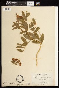 Lathyrus venosus var. intonsus Butters & H. St. John 138756[1077360]Skinner, S. 2161902-06-25 United States, Minnesota, Murray, Lake Talcot. W side.;;N;;, 43.881403 -95.467012 |
MIN:Plants | 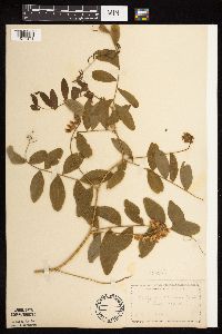 Lathyrus venosus var. intonsus Butters & H. St. John 138760[1077373]Manning, Sara s.n.1892-07-23 United States, Minnesota, Wabasha, Lake City;;111N;12W;, 44.449412 -92.266844 |
MIN:Plants | 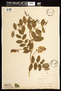 Lathyrus venosus var. intonsus Butters & H. St. John 138761[1077452]G. & L. 32-311884-06-04 United States, Minnesota, Chippewa, Near Heagy's, Upper Minn. [River]. Chippewa Co.;;117N;40W;, 44.95377 -95.776947 |
MIN:Plants | 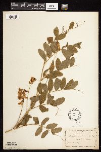 Lathyrus venosus var. intonsus Butters & H. St. John 138762[1077426]Manning, Sara s.n.1883-06-14 United States, Minnesota, Wabasha, Lake City;;111N;12W;, 44.449412 -92.266844 |
MIN:Plants |  Lathyrus venosus var. intonsus Butters & H. St. John 138763[1077413]Kassube, J. s.n.1878-06-00 United States, Minnesota, Hennepin, Minneapolis;;N;;, 44.970736 -93.268643 |
MIN:Plants |  Lathyrus venosus var. intonsus Butters & H. St. John 138764[1077414]Butters, F. s.n.1895-05-31 United States, Minnesota, Hennepin, Washburn Park;;N;;, 44.91075 -93.284381 |
MIN:Plants |  Lathyrus venosus var. intonsus Butters & H. St. John 138765[1077351]Aiton, G. s.n.1891-07-00 United States, Minnesota, Clearwater, Lake Itasca;Itasca State Park;143N;36W;, 47.215169 -95.19703 |
MIN:Plants |  Lathyrus venosus var. intonsus Butters & H. St. John 138766[1122718]Aiton, G. s.n.1891-06-00 United States, Minnesota, Nicollet, Nicollet Co.;;N;;, 44.363625 -94.316053 |
MIN:Plants |  Lathyrus venosus var. intonsus Butters & H. St. John 138767[1077486]Frost, W. F1231892-06-00 United States, Minnesota, Meeker, Litchfield;;N;;, 45.127185 -94.528047 |
MIN:Plants |  Lathyrus venosus var. intonsus Butters & H. St. John 138768[1122721]Aiton, G. s.n. United States, Minnesota, Nicollet, Nicollet Co.;;N;;, 44.363625 -94.316053 |
MIN:Plants |  Lathyrus venosus var. intonsus Butters & H. St. John 138769[1122719]Sandberg, John s.n.1889-06-00 United States, Minnesota, Hennepin, [no further data];;;;, 45 -93.47 |
MIN:Plants |  Lathyrus venosus var. intonsus Butters & H. St. John 138770[1077491]Holzinger, John s.n.1888-06-19 United States, Minnesota, Winona, Winona;;107N;06W;00, 44.02403 -91.57548 |
MIN:Plants |  Lathyrus venosus var. intonsus Butters & H. St. John 138772[1077498]Ballard, C. B12531893-06-00 United States, Minnesota, Cass, Little Gull Lake;;N;;, 46.44354 -94.364036 |
MIN:Plants |  Lathyrus venosus var. intonsus Butters & H. St. John 138773[1077349]Anderson, A. A4221893-06-00 United States, Minnesota, Cass, Gull Lake;;N;;, 46.445433 -94.36335 |
MIN:Plants |  Lathyrus venosus var. intonsus Butters & H. St. John 138774[1077355]Sheldon, Edmund s.n.1895-06-00 United States, Minnesota, Ramsey, St. Anthony Park [St. Paul neighborhood near U of M];;029N;23W;, 44.983574 -93.195102 |
MIN:Plants |  Lathyrus venosus var. intonsus Butters & H. St. John 138775[1077359]Tilden, Josephine Tn251893-06-00 United States, Minnesota, Cass, Gull Lake;;N;;, 46.445433 -94.36335 |
MIN:Plants |  Lathyrus venosus var. intonsus Butters & H. St. John 138776[1077358]Sheldon, Edmund S23601892-06-00 United States, Minnesota, Aitkin, Farm Island Lake;;N;;, 46.422761 -93.772193 |
MIN:Plants |  Lathyrus venosus var. intonsus Butters & H. St. John 138777[1077447]Sandberg, John s.n.1891-06-00 United States, Minnesota, Pine, Pokegama Lake. Pine Co.;;039N;22W;, 45.844329 -93.038558 |
MIN:Plants |  Lathyrus venosus var. intonsus Butters & H. St. John 138778[1122724]Sandberg, John s.n.1889-06-00 United States, Minnesota, Hennepin, [no further data];;;;, 45 -93.47 |
MIN:Plants |  Lathyrus venosus var. intonsus Butters & H. St. John 138779[1077490]Lyon, H. s.n.1899-06-06 United States, Minnesota, Houston, Winnebago Valley;Dorer Memorial Hardwood State Forest;;;, 43.66667 -91.50056 |
MIN:Plants |  Lathyrus venosus var. intonsus Butters & H. St. John 138780[1077330]Campbell, Jennie s.n.1897-07-00 United States, Minnesota, Otter Tail, Girard;;133N;39W;, 46.349789 -95.575561 |
MIN:Plants |  Lathyrus venosus var. intonsus Butters & H. St. John 226225[1077430]Roberts, Thomas s.n.1904-07-00 United States, Minnesota, Wabasha, Brook Lodge;;N;;, 44.277558 -92.210339 |
MIN:Plants |  Lathyrus venosus var. intonsus Butters & H. St. John 226242[1077429]Stork, H. 12541925-00-00 United States, Minnesota, Itasca, Bowstring;Chippewa National Forest;;;, 47.54306 -93.79639 |
MIN:Plants |  Lathyrus venosus var. intonsus Butters & H. St. John 226472[1122725]Holzinger, John s.n.1901-06-00 United States, Minnesota, Winona, Winona Co.;;N;;, 43.978945 -91.713211 |
MIN:Plants |  Lathyrus venosus var. intonsus Butters & H. St. John 226515[1077457]Rosendahl, C.; Butters, F. 47011924-07-08 United States, Minnesota, Anoka, S of Moore lake;;030N;24W;, 45.070315 -93.247378 |
MIN:Plants |  Lathyrus venosus var. intonsus Butters & H. St. John 265649[1077463]Stevenson, J. 1171912-07-05 United States, Minnesota, Beltrami, Bemidji;;N;;, 47.479828 -94.863111 |
MIN:Plants |  Lathyrus venosus var. intonsus Butters & H. St. John 265666[1077353]Stevenson, J. 682000-06-25 United States, Minnesota, Beltrami, Bemidji;;N;;, 47.479828 -94.863111 |
MIN:Plants |  Lathyrus venosus var. intonsus Butters & H. St. John 270259[1077369]Manning, Sara s.n.1884-07-18 United States, Minnesota, Goodhue, Central Point [pioneer town on Sand Point, Lake Pepin];Frontenac State Park;112N;13W;12, 44.51982 -92.31912 |
MIN:Plants |  Lathyrus venosus var. intonsus Butters & H. St. John 271061[1077312]Budde, C. s.n.1896-05-17 United States, Minnesota, Blue Earth, Mankato;;N;;, 44.17072 -93.992534 |
MIN:Plants |  Lathyrus venosus var. intonsus Butters & H. St. John 271276[1077389]G., F. s.n.1922-06-08 United States, Minnesota, Ramsey, Doswell Ave. and Como, St. Paul;;029N;23W;, 44.982381 -93.195816 |
MIN:Plants |  Lathyrus venosus var. intonsus Butters & H. St. John 276061[1077346]Grant, Martin 27361929-07-10 United States, Minnesota, Clearwater, Itasca Park. Near campus. SE1/4 SE1/4 T143N, R36W;Itasca State Park;143N;36W;2, 47.1452906 -95.2013601 |
MIN:Plants |  Lathyrus venosus var. intonsus Butters & H. St. John 276277[1077375]Flygare, L. s.n.1923-07-16 United States, Minnesota, Martin, Road to Fox Lake;;N;;, 43.66932 -94.728045 |
MIN:Plants |  Lathyrus venosus var. intonsus Butters & H. St. John 276883[1077499]Huff, N. 251914-07-02 United States, Minnesota, Lake, North Kawishiwi River;Boundary Waters Canoe Area Wilderness / Superior National Forest;N;;, 47.919582 -91.611941 |
MIN:Plants |  Lathyrus venosus var. intonsus Butters & H. St. John 277162[1077352]Anonymous 47111924-07-17 United States, Minnesota, Clearwater, Itasca Park;Itasca State Park;143N;36W;, 47.195125 -95.230803 |
MIN:Plants |  Lathyrus venosus var. intonsus Butters & H. St. John 278148[1077485]Roberts, Thomas s.n.1878-06-15 United States, Minnesota, Hennepin, Minneapolis;;N;;, 44.970736 -93.268643 |
MIN:Plants |  Lathyrus venosus var. intonsus Butters & H. St. John 301978[1077474]Quick, R. 231928-05-00 United States, Minnesota, Washington, Lake St. Croix;;;;, 44.902745 -92.783537 |
MIN:Plants |  Lathyrus venosus var. intonsus Butters & H. St. John 306923[1077383]Cottrell, R. s.n.1935-06-23 United States, Minnesota, Anoka, Roadside, Fridley region;;030N;24W;, 45.078804 -93.265342 |
MIN:Plants |  Lathyrus venosus var. intonsus Butters & H. St. John 333564[1077497]Lakela, Olga 12591935-06-28 United States, Minnesota, Carlton, Jay Cooke Park;Jay Cooke State Park;048N;16W;, 46.648722 -92.354781 |
MIN:Plants |  Lathyrus venosus var. intonsus Butters & H. St. John 348615[1077471]Eneboe, H. 341937-06-19 United States, Minnesota, Hennepin, S of Franklin Avenue, SE, Minneapolis City limits;;N;;, 44.961909 -93.211908 |
MIN:Plants |  Lathyrus venosus var. intonsus Butters & H. St. John 354795[1077348]Moyle, J. 12861934-07-21 United States, Minnesota, Cass, Near Cass Lake;Chippewa National Forest / Leech Lake Indian Reservation;N;;, 47.38428 -94.59488 |
MIN:Plants |  Lathyrus venosus var. intonsus Butters & H. St. John 355526[1077329]Lakela, Olga 30661939-06-28 United States, Minnesota, Saint Louis, Lake bank, 18 mi N of Duluth, hwy 53;;N;;, 47.053211 -92.452648 |
MIN:Plants |  Lathyrus venosus var. intonsus Butters & H. St. John 355970[1077328]Lakela, Olga 30301939-06-25 United States, Minnesota, Saint Louis, Clearing, hwy 20, ca. 8 mi S of Biwabik;;N;;, 47.417183 -92.340179 |
MIN:Plants |  Lathyrus venosus var. intonsus Butters & H. St. John 357244[1077350]Stevenson, J. 3191912-08-15 United States, Minnesota, Itasca, Grand Rapids;;055N;25W;, 47.225976 -93.523348 |
MIN:Plants |  Lathyrus venosus var. intonsus Butters & H. St. John 357245[1077378]Stevenson, J. 3541912-08-22 United States, Minnesota, Itasca, Grand Rapids;;N;;, 47.225976 -93.523348 |
MIN:Plants | 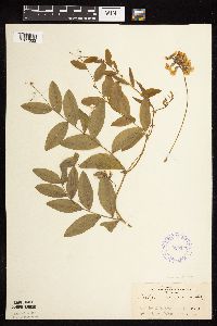 Lathyrus venosus var. intonsus Butters & H. St. John 358120[1077332]Rosendahl, C. 4241902-06-08 United States, Minnesota, Houston, Spring Grove;;101N;07W;, 43.561578 -91.635292 |
MIN:Plants | 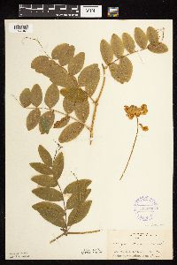 Lathyrus venosus var. intonsus Butters & H. St. John 358679[1077347]Rosendahl, C. 4251902-06-08 United States, Minnesota, Houston, Spring Grove;;101N;07W;, 43.561578 -91.635292 |
MIN:Plants | 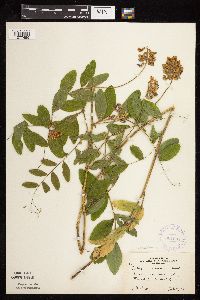 Lathyrus venosus var. intonsus Butters & H. St. John 364694[1077496]Moyle, J. 36001940-07-08 United States, Minnesota, Saint Louis, Along French River;;N;;, 46.918632 -91.920817 |
MIN:Plants | 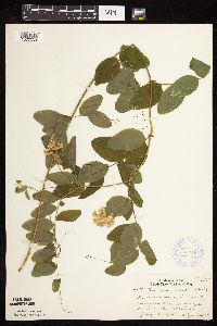 Lathyrus venosus var. intonsus Butters & H. St. John 368758[1077333]Lakela, Olga 45391941-07-23 United States, Minnesota, Saint Louis, Brink of Vermilion River gorge;;N;;, 48.275739 -92.506548 |
MIN:Plants | 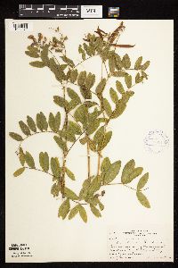 Lathyrus venosus var. intonsus Butters & H. St. John 370917[1077376]Moore, John 132311940-06-22 United States, Minnesota, Sibley, Along the rr 1/4 mi E of Gibbon, Sibley Co.;;112N;31W;, 44.532445 -94.517687 |
MIN:Plants | 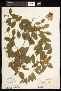 Lathyrus venosus var. intonsus Butters & H. St. John 370988[1077427]Moore, John; Moore, Marjorie 132951940-06-25 United States, Minnesota, Kanabec, E shore of Knife Lake;;N;;, 45.978509 -93.286663 |
MIN:Plants | 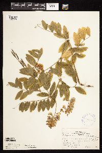 Lathyrus venosus var. intonsus Butters & H. St. John 371012[1077325]Moore, John; Moore, Marjorie 129641940-06-12 United States, Minnesota, Dakota, Beside rr right of way, S edge of Inver Grove;;N;;, 44.80525 -93.035343 |
MIN:Plants | 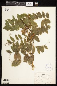 Lathyrus venosus var. intonsus Butters & H. St. John 372111[1077377]Moore, John; et al. 144651941-06-15 United States, Minnesota, Marshall, Marshall County...Beside hwy 32, 1 mi S of Holt;;;;, 48.277443 -96.192531 |
Google Map
Google Maps is a web mapping service provided by Google that features a map that users can pan (by dragging the mouse) and zoom (by using the mouse wheel). Collection points are displayed as colored markers that when clicked on, displays the full information for that collection. When multiple species are queried (separated by semi-colons), different colored markers denote each individual species.