University of Minnesota
http://www.umn.edu/
612-625-5000
http://www.umn.edu/
612-625-5000
Minnesota Biodiversity Atlas
Bell Museum
Dataset: MIN-Plants
Taxa: Alismataceae
Search Criteria: excluding cultivated/captive occurrences
Bell Museum plants | |
 MIN:Plants | Sagittaria latifolia Willdenow 917203[]Gerdes, Lynden; et al. 56942008-08-26 United States, Minnesota, Lake, T65N R11W S22NWNESW. Lake County MN. Superior National Forest. Boundary Waters Canoe Area Wilderness. Horse River.;Boundary Waters Canoe Area Wilderness / Superior National Forest;065N;11W;22, 48.1011111 -91.7277778 |
MIN:Plants | Sagittaria latifolia Willdenow 524456[]Benner, J. s.n.1945-09-01 United States, Wisconsin, Polk, Polk County: St. Croix Falls 7 miles north near the river road.;Saint Croix National Riverway;;;, 45.495248 -92.699726 |
MIN:Plants | Sagittaria latifolia Willdenow 146422[]DeMink, L. 3731999-08-20 United States, Minnesota, Morrison, Crane Meadows National Wildlife Refuge;Crane Meadows National Wildlife Refuge;040N;31W;, 45.933896 -94.251564 |
MIN:Plants | Sagittaria latifolia Willdenow 224490[]Cooper, William 2591910-08-23 United States, Michigan, Keweenaw, McCargoe's Cove, Isle Royale;Isle Royale National Park |
MIN:Plants | Sagittaria latifolia Willdenow 485049[]Wheeler, Gerald 194111998-06-24 United States, Minnesota, Sibley, Sibley County ... Ca. 2.1 mi. NNE of New Auburn; Schilling Lake. Along NE shore of lake ... SW1/4 Sec. 4 T114N R28W (New Auburn 4). 114N 28W 4, 44.70379 -94.20617 |
MIN:Plants | Sagittaria latifolia Willdenow 224483[]Cooper, William 2591910-08-23 United States, Michigan, Keweenaw, McCargoe's Cove, Isle Royale;Isle Royale National Park |
MIN:Plants | Sagittaria latifolia Willdenow 915055[]Smith, Welby; et al. 313852009-08-26 United States, Minnesota, Cook, Boundary Waters Canoe Area Wilderness / Superior National Forest. Cook County...Boundary Waters Canoe Area Wilderness, Superior National Forest. About 1/4 mile south of Winchell Lake along the outlet of Tremble Lake...T 64N R 2W SW1/4 of NE1/4 of Sec 32. 064N 02W 32, 47.9863889 -90.6041667 |
MIN:Plants | Sagittaria latifolia Willdenow 911888[]Cholewa, A. 26672009-08-07 United States, Minnesota, Anoka, Martin-Island-Linwood Lakes County Park. Anoka County, Linwood Lake County Park, boat ramp at northeast end of lake, along man-made fishing peninsula west of ramp. T33N R22W Sec 9.. 033N 22W 9, 45.356824 -93.097084 |
MIN:Plants | Sagittaria latifolia Willdenow 461390[]Gerdes, Lynden; et al. 28621998-07-06 United States, Minnesota, Cook, Boundary Waters Canoe Area Wilderness / Superior National Forest. T65N R02E S26SENW. Cook County; Superior National Forest, BWCAW. Wetland complex ~ 0.4 miles NE of the far NE of the far NE corner of West Pike Lake.. 065N 02E 26, 48.085574 -90.154825 |
MIN:Plants | Sagittaria latifolia Willdenow 920975[]Lee, Michael MDL34232003-06-18 United States, Minnesota, Todd, Todd County...seven miles northeast of Eagle Bend...T132N R34W NW1/4 of SW1/4 of NE1/4 Sec. 24;;132N;34W;24, 46.230558 -94.905272 |
MIN:Plants | Sagittaria latifolia Willdenow 430312[]Lee, Michael MDL18591997-07-22 United States, Minnesota, Stearns, Stearns Co.; Birch Lakes State Forest 4 miles south-southwest of Grey Eagle; T127N R33W NW1/4 of SW1/4 of NE1/4 Sec. 36;Birch Lakes State Forest;127N;33W;36, 45.766948 -94.777658 |
MIN:Plants | Sagittaria latifolia Willdenow 507977[]Gerdes, Lynden 29201998-07-16 United States, Minnesota, Cook, T65N R03E S03SWNW. Cook County...Superior National Forest. West shore of Little John Lake.;Superior National Forest;065N;03E;03, 48.059579 -90.054584 |
MIN:Plants | Sagittaria latifolia Willdenow 908333[]Gerdes, Lynden 54932007-08-01 United States, Minnesota, Lake, Boundary Waters Canoe Area Wilderness / Superior National Forest. T61N R07W S01NENE. Lake County, MN. Superior National Forest. Perent Lake, BWCAW. Protected shallow bay at northern end of the larger island at western end of lake...NAD 83 / 638427 / 5295924. 061N 07W 1, 47.808243 -91.141406 |
MIN:Plants |  Sagittaria latifolia Willdenow 414590[1299433]Jones, George Neville 189101949-08-29 United States, Illinois, Vermilion, Middle Fork Vermilion river, Kickapoo State Park, near Oakwood, Vermilion County |
MIN:Plants | Sagittaria latifolia Willdenow 524434[]Benner, J. s.n.1945-09-01 United States, Wisconsin, Polk, Polk County: St. Croix Falls 7 miles north near the river road.;Saint Croix National Riverway;;;, 45.495248 -92.699726 |
MIN:Plants | Sagittaria latifolia Willdenow 472828[]Lee, Michael MDL15481996-09-06 United States, Minnesota, Mille Lacs, Mille Lacs Kathio State Park. Mille Lacs Co.; Mille Lacs Kathio State Park; Black Bass Lake 4-1/2 miles WNW of Onamia; T42N R27W SE1/4 Sec. 11 SW1/4 Sec. 12, NW1/4 Sec. 13, NE1/4 Sec. 14. 042N 27W , 46.127266 -93.704513 |
MIN:Plants | Sagittaria latifolia Willdenow 580799[]Juhnke, C. 073 CMJ FRO1998-09-02 United States, Minnesota, Goodhue, Frontenac State Park Goodhue County ... Along trail to Sand Point ...T112N R13W SE NW NE 13;Frontenac State Park;112N;13W;13, 44.507869 -92.316603 |
MIN:Plants | Sagittaria latifolia Willdenow 61053[]Beardslee, H.; et al. s.n.1891-08-08 United States, North Carolina, Swain, Great Smoky Mountains...Swain County;Great Smoky Mountains National Park, 518m |
MIN:Plants | Sagittaria latifolia Willdenow 917141[]Gerdes, Lynden; et al. 56942008-08-26 United States, Minnesota, Lake, T65N R11W S22NWNESW. Lake County MN. Superior National Forest. Boundary Waters Canoe Area Wilderness. Horse River.;Boundary Waters Canoe Area Wilderness / Superior National Forest;065N;11W;22, 48.1011111 -91.7277778 |
MIN:Plants | Sagittaria latifolia Willdenow 927189[]Fevold, Brick 371994-08-10 United States, Minnesota, Lake of the Woods, Roseau River Flowage;Beltrami Island State Forest;159N;36W;, 48.584349 -95.274742 |
MIN:Plants | Sagittaria latifolia Willdenow 924745[]Rowe, Erika ERR4072008-08-01 United States, Minnesota, Hubbard, 1 mile west of Cty Hwy 45; 0.85 mile south of Cty Hwy 16; 2.25 miles SE of Guthrie; Hart lake, south side. SESE of section.;;144N;32W;17, 47.285 -94.75 |
MIN:Plants | Sagittaria latifolia Willdenow 930630[]Gerdes, Lynden B.; Doerr, Andrea L. 61192010-07-18 United States, Minnesota, Cook, Western shore of small island near the southwest portion of Paulson Lake. NE1/4 of SW1/4 of section;Superior National Forest;065N;05W;24, 48.0983333 -90.9138889 |
MIN:Plants | Sagittaria latifolia Willdenow 932237[]Lee, Michael MDL47552008-08-04 United States, Minnesota, Cass, 4.5 miles northeast of Leader, 13 miles west of Pequot Lakes. On south shore of Camp Two Lake. NE1/4 of SW1/4 of section;;136N;31W;21, 46.5775333 -94.5954511 |
MIN:Plants | Sagittaria latifolia Willdenow 934140[]Smith, Welby R. 335512011-08-29 United States, Minnesota, Dakota, About 7 miles N-NW of Northfield. NE of SE of section;Chub Lake Wildlife Area;113N;20W;33, 44.5510333 -93.22245 |
MIN:Plants | Sagittaria latifolia Willdenow 934131[]Smith, Welby R. 335662011-09-14 United States, Minnesota, Faribault, About 2 miles east of Winnebago. SE of NE of section;Rice Lake Wildlife Management Area;104N;27W;31, 43.7675667 -94.1077167 |
MIN:Plants | Sagittaria latifolia Willdenow 933906[]Smith, Welby R. 214071992-08-12 United States, Minnesota, Marshall, About 11 miles east of Argyle. NW1/4 of SE1/4 of section;Old Mill State Park;156N;46W;04, 48.3602778 -96.5702778 |
MIN:Plants | Sagittaria latifolia Willdenow 935367[]Smith, Welby R; Gerdes, Lynden B 333002011-08-09 United States, Minnesota, Lake, At the west end of Lake Isabella where it joins the Isabella River. SE of NW of section;Boundary Waters Canoe Area Wilderness / Superior National Forest;062N;07W;31, 47.8108667 -91.2675167 |
MIN:Plants | Sagittaria latifolia Willdenow 936800[]Smith, Welby R. 297312006-07-27 United States, Minnesota, Lincoln, About 4.5 miles south-southwest of Lake Benton (town). SE of SE of section;Altona Wildlife Management Area;109N;46W;36, 44.1996976 -96.3271042 |
MIN:Plants | Sagittaria latifolia Willdenow 936803[]Smith, Welby R. 297432006-08-02 United States, Minnesota, Freeborn, About 5 miles northwest of Austin. SW of SW of section;Carex Wildlife Management Area;103N;19W;15, 43.7199012 -93.1054529 |
MIN:Plants | Sagittaria latifolia Willdenow 936805[]Smith, Welby R. 297482006-08-02 United States, Minnesota, Steele, About 5 miles NW of Blooming Prairie. NW of SE of section;Pogones Wildlife Management Area;105N;19W;18, 43.8986111 -93.1222222 |
MIN:Plants | Sagittaria latifolia Willdenow 936806[]Smith, Welby R. 297492006-08-02 United States, Minnesota, Steele, At the marshy edge of Oak Glenn Lake. Habitat NW of SW of section;;105N;19W;02, 43.9256031 -93.0817471 |
MIN:Plants | Sagittaria latifolia Willdenow 936811[]Smith, Welby R. 297552006-08-03 United States, Minnesota, Chippewa, Along the southwest shore of Watson Sag. NW of NW of section;Lac Qui Parle Wildlife Management Area;118N;41W;08, 45.0487251 -95.8345794 |
MIN:Plants | Sagittaria latifolia Willdenow 936815[]Smith, Welby R. 297622006-08-03 United States, Minnesota, Swift, At the mouth of the Pomme de Terre River where it enters Marsh Lake. SW of NE of section;Lac Qui Parle Wildlife Management Area;120N;43W;30, 45.1766912 -96.0893573 |
MIN:Plants | Sagittaria latifolia Willdenow 936816[]Smith, Welby R. 297632006-08-03 United States, Minnesota, Chippewa, A shallow backwater of the Lac Qui Parle River. SW of SW of section;Lac Qui Parle Wildlife Management Area;118N;41W;02, 45.0533357 -95.7731728 |
MIN:Plants | Sagittaria latifolia Willdenow 936967[]Smith, Welby R. 302492007-07-11 United States, Minnesota, Marshall, SW of NW of section;Thief Lake Wildlife Management Area;158N;39W;31, 48.4631926 -95.7269614 |
MIN:Plants | Sagittaria latifolia Willdenow 936817[]Smith, Welby R. 297642006-08-03 United States, Minnesota, Chippewa, SE of NW of section;Lac Qui Parle Wildlife Management Area;118N;42W;01, 45.0608124 -95.8720319 |
MIN:Plants | Sagittaria latifolia Willdenow 936818[]Smith, Welby R. 297702006-08-08 United States, Minnesota, Faribault, About 7 miles southwest of Winnebago. NE of SW of section;Smith Wildlife Management Area;104N;27W;03, 43.8377426 -94.0609694 |
MIN:Plants | Sagittaria latifolia Willdenow 936820[]Smith, Welby R. 297732006-08-08 United States, Minnesota, Faribault, About 21 miles west of Albert Lea. SE of NE of section;Walnut Wildlife Management Area;102N;24W;03, 43.6691667 -93.6919444 |
MIN:Plants | Sagittaria latifolia Willdenow 936821[]Smith, Welby R. 297752006-08-08 United States, Minnesota, Freeborn, A wide mashy zone at the east end of Lower Twin Lake. NE of SE of section;;101N;22W;11, 43.5617633 -93.4321641 |
MIN:Plants | Sagittaria latifolia Willdenow 936824[]Smith, Welby R. 297812006-08-09 United States, Minnesota, Martin, A marshy habitat at the south end of South Silver Lake, about 10 miles south of Fairmont. NW of NW of section;;101N;30W;32, 43.5123511 -94.4634429 |
MIN:Plants | Sagittaria latifolia Willdenow 936826[]Smith, Welby R. 297852006-08-09 United States, Minnesota, Martin, At the southeast end of Bright Lake, in Bright Lake County Park. SW of NE of section;;101N;31W;17, 43.5541788 -94.5783542 |
MIN:Plants | Sagittaria latifolia Willdenow 936828[]Smith, Welby R. 297862006-08-11 United States, Minnesota, Dakota, At the edge of a small pond in the Mississippi River bottoms, about 0.5 mile east of Hastings. SE of SE of section;;115N;17W;27, 44.733937 -92.8365107 |
MIN:Plants | Sagittaria latifolia Willdenow 936827[]Smith, Welby R. 297882006-08-11 United States, Minnesota, Goodhue, In wet, silty soil at the margin of North Lake in the Mississippi River bottoms, about 9 miles southeast of Hastings.;;114N;16W;22, 44.669977 -92.720962 |
MIN:Plants | Sagittaria latifolia Willdenow 936831[]Smith, Welby R. 297912006-08-14 United States, Minnesota, Houston, In Reno Bottoms, a backwater of the Mississippi River about 3 miles north of the Iowa border. NE of NE of section;;101N;04W;23, 43.5412222 -91.2763856 |
MIN:Plants | Sagittaria latifolia Willdenow 936832[]Smith, Welby R. 297942006-08-15 United States, Minnesota, Goodhue, About 11 miles north of Kenyon. SE of SW of section;Warsaw Wildlife Management Area;111N;18W;08, 44.4312444 -93.0135671 |
MIN:Plants | Sagittaria latifolia Willdenow 937060[]Smith, Welby R. 322452010-09-04 United States, Minnesota, Cook, On the south side of Mink Lake, about 9 miles northeast of Grand Marais. NW of SW of section;North Shore / Superior National Forest;062N;02E;08, 47.8644444 -90.2286111 |
MIN:Plants | Sagittaria latifolia Willdenow 463260[]Smith, Welby R. 298252006-08-18 United States, Minnesota, Blue Earth, About 2 miles west of Madison Lake (town). SW of NW of section;;109N;25W;33, 44.2060302 -93.844737 |
MIN:Plants | Sagittaria latifolia Willdenow 428969[]Smith, Welby R. 298332006-08-18 United States, Minnesota, Watonwan, West end of Long lake, about 6 miles south-southwest of St. James. SW of SW of section;;105N;32W;10, 43.9086112 -94.6759284 |
MIN:Plants | Sagittaria latifolia Willdenow 428959[]Smith, Welby R. 298432006-08-21 United States, Minnesota, Le Sueur, At the east end of Lake Francis, about one mile north of Elysian. SE of NW of section;;105N;24W;35, 44.210516 -93.703839 |
MIN:Plants | Sagittaria latifolia Willdenow 267076[]Smith, Welby R. 298452006-08-25 United States, Minnesota, Waseca, North end of Goose Lake, about 3 miles east of Waseca. NW of SE of section;;107N;22W;11, 44.0847946 -93.4328979 |
MIN:Plants | Sagittaria latifolia Willdenow 385947[]Smith, Welby R. 298642006-08-29 United States, Minnesota, Scott, Louisville Swamp, about 7 miles southwest of Shakopee. NE of SE of section;;115N;23W;31, 44.726293 -93.627916 |
MIN:Plants | Sagittaria latifolia Willdenow 178427[]Smith, Welby R. 298862006-09-01 United States, Minnesota, Carver, Just across the main channel (Minnesota River) from Shakopee, off the Hwy 101 crossing. NW of NE of section;;115N;23W;01, 44.8020959 -93.5267408 |
MIN:Plants | Sagittaria latifolia Willdenow 137720[]Smith, Welby R. 298942006-09-06 United States, Minnesota, Scott, In the Minnesota River bottoms just west of Savage. SE of SE of section;;115N;22W;01, 44.7925242 -93.4024204 |
MIN:Plants | Sagittaria latifolia Willdenow 461892[]Smith, Welby R. 320722010-08-27 United States, Minnesota, Lake, Forest Hwy 11, about 5 miles northwest of Silver Bay. SE of NE of section;;056N;08W;21, 47.3236809 -91.3485343 |
MIN:Plants | Sagittaria latifolia Willdenow 942087[]Smith, Welby R. 319372010-07-29 United States, Minnesota, Koochiching, Small roadside marsh about 2 miles west of Gemmell. NE of SE of section;;152N;28W;24, 47.9666664 -94.1705556 |
MIN:Plants | Sagittaria latifolia Willdenow 904860[]Smith, Welby R. 32080A2010-08-26 United States, Minnesota, Cook, At the public access to Irish Creek, about 6 miles north of Hovland. SW of SW of section;;063N;04E;17, 47.933333 -89.9666667 |
MIN:Plants |  Sagittaria latifolia Willdenow 945869[1291595]Smith, Welby R. WRS340852012-07-30 United States, Minnesota, Goodhue, Perched Valley State Wildlife Management Area, about 2 miles (3.2 km) west of Frontenac. NE of SW of section; T112N R13W sec08, 44.5172833 -92.4041333 |
MIN:Plants |  Sagittaria latifolia Willdenow 948418[1292530]Smith, Welby R. 341982012-08-17 United States, Minnesota, Jackson, In Robertson County Park on the east side of Loon Lake, about 8.5 miles (13.5 km) southwest of the town of Jackson.; T101N R36W sec24, 43.5305333 -95.0988 |
MIN:Plants |  Sagittaria latifolia Willdenow 947747[1291818]Smith, Welby R. 297132006-07-21 United States, Minnesota, Fillmore, Geothite State Wildlife Management Area, about 5 miles south of Spring Valley. NE of SW of section; T102N R13W sec23, 43.6211482 -92.3633056 |
MIN:Plants |  Sagittaria latifolia Willdenow 947755[1291826]Smith, Welby R. 297322006-07-27 United States, Minnesota, Lincoln, About 2 miles south-southwest of Lake Benton (town). NW of NW of section; T109N R45W sec20, 44.2386618 -96.2973947 |
MIN:Plants |  Sagittaria latifolia Willdenow 943537[1297064]Smith, Welby R. 34239 United States, Minnesota, Mower |
MIN:Plants |  Sagittaria latifolia Willdenow 943572[1297130]Smith, Welby R. 342762012-09-11 United States, Minnesota, Sibley |
MIN:Plants |  Sagittaria latifolia Willdenow 962806[1346433]Dahlberg, Nathan B. NBD1182018-09-10 United States, Minnesota, Koochiching, Big Fork River, 431m south of county rd 5; 5.19mi east of hwy 6; 19mi south southeast of Big Falls., 47.93 -93.65 |
MIN:Plants |  Sagittaria latifolia Willdenow 965139[1375809]Lee, Michael MDL50792009-08-19 United States, Minnesota, Cook, Boundary Waters Canoe Area Wilderness, Rugged bedrock terrain northwest of Brule Lake, 24 miles northwest of Grand Marais. T63N R3W W1/2 of NW1/4 of NW1/4 Sec. 5 (or E1/2 of NE1/4 of NE1/4 Sec. 6), 47.97281573 -90.74432682 |
MIN:Plants |  Sagittaria latifolia Willdenow 965527[1356394]Lee, Michael MDL54742010-09-11 United States, Minnesota, Cook, Boundary Waters Canoe Area Wilderness, Rolling to fairly rugged bedrock terrain between the Brule River and Lima Mountain, 17 miles north-northwest of Grand Marais. T64N R1W N1/2 of NE1/4 of NW1/4 Sec. 34, 47.99020029 -90.44057768, 570m |
MIN:Plants |  Sagittaria latifolia Willdenow 976727[1402336]Timothy J. S. Whitfeld 29952021-07-20 United States, Minnesota, St. Louis, Between Crane Lake and Dovre Lake, 48.27375 -92.447243, 364m |
MIN:Plants |  Sagittaria latifolia Willdenow 967356[1359911]Welby R Smith 354292015-09-08 United States, Minnesota, Goodhue, At the margin of a low, sandy/silty island in North Lake, just off the main channel of the Mississippi River; 14.6 km (9 miles) southeast of the approximate center of Hastings. NW of NE of section, 44.6716 -92.6973667 |
MIN:Plants |  Sagittaria latifolia Willdenow 967438[1359993]Welby R Smith 356482016-07-26 United States, Minnesota, Hennepin, Lake Rebecca Park Reserve about 3 km (1.9 miles) northeast of the approximate center of Delano. SW of NW of section, 45.05925 -93.7621389 |
MIN:Plants |  Sagittaria latifolia Willdenow 967452[1368007]Welby R Smith 356632016-09-01 United States, Minnesota, Steele, At the northwest end of Rice Lake in Rice Lake State Park, about 13 km (8 miles) east of the approximate center of Owatonna. SE of NE of section, 44.0883167 -93.0683 |
MIN:Plants |  Sagittaria latifolia Willdenow 968213[1368825]Timothy J. S. Whitfeld 16342017-08-16 United States, Rhode Island, Washington, Frying Pan Pond, Wood River, 0.75 miles north-northwest of dam on Arcadia Road., 41.54914 -71.70397 |
MIN:Plants | Sagittaria latifolia Willdenow []Timothy J. S. Whitfeld 32892022-07-06 United States, Minnesota, Swift, Appleton 18 Native Prairie Bank, 3.6 miles west of Appleton, 45.197618 -96.0968877, 294m |
MIN:Plants |  Sagittaria latifolia Willdenow 969997[1371582]Brad Bolduan 2082020-09-10 United States, Minnesota, Cottonwood, Talcot Lake Wildlife Management Area., 43.903744 -95.446453 |
MIN:Plants |  Sagittaria latifolia Willdenow 971113[1394582]Smith, Welby R WRS360782018-08-21 United States, Minnesota, Washington, Lamprey Pass State Wildlife Management Area, about 3.4 km (2.1 miles) southwest of the approximate center of Forest Lake (town), at a heading of 231 degrees. At the southernmost point of Mud Lake., 45.2602667 -93.0187167 |
MIN:Plants |  Sagittaria latifolia Willdenow 971126[1394595]Smith, Welby R WRS360952018-08-30 United States, Minnesota, Washington, Paul Hugo Farms State Wildlife Managemet Area. On the east side of Rice Lake, within the municipal boundaries of Hugo., 45.16305 -92.9621333 |
MIN:Plants |  Sagittaria latifolia Willdenow 971136[1394605]Smith, Welby R WRS361022018-08-30 United States, Minnesota, Washington, Hardwood Creek State Wildlife Management Area, about 6.45 km (4 miles) southeast (at 147 degrees) from the junction of Co Rd 2 and State Hwy 61 in Forest Lake., 45.2305667 -92.9400667 |
MIN:Plants | Sagittaria latifolia Willdenow []Timothy J. S. Whitfeld 35932023-07-06 United States, Minnesota, Marshall, Agassiz National Wildlife Refuge, Agassiz Wilderness Area, 1 mile west of Webster Creek Pool, 4.7 miles north of main administration building, 48.3689 -95.96569, 346m |
MIN:Plants |  Sagittaria latifolia Willdenow 976094[1373647]Smith, Welby R WRS368492020-08-17 United States, Minnesota, Anoka, Wollan Park in Lino Lakes. In a very diverse wet meadow community., 45.2062 -93.09985 |
MIN:Plants |  Sagittaria latifolia Willdenow 976106[1373659]Smith, Welby R WRS368292020-08-15 United States, Minnesota, Wright, On the northeast side of Pelican Lake, about 7 km (4.35 miles) southeast of the approximate center of Monticello., 45.252978 -93.748712 |
MIN:Plants |  Sagittaria latifolia Willdenow 976293[1373846]Smith, Welby R WRS369652020-08-31 United States, Minnesota, Ramsey, Snail Lake Regional Park in Shoreview. At the eastern tip of Grass Lake., 45.057732 -93.108899 |
MIN:Plants |  Sagittaria latifolia Willdenow 976194[1373746]Smith, Welby R WRS369982020-09-08 United States, Minnesota, Hennepin, Along the north shore of Prairie Lake in Crow-Hassan Regional Park; about 5.6 km (3.5 miles) S-SE of the junction of Interstate 94 and Hwy 19 in Albertville., 45.192526 -93.64499 |
MIN:Plants |  Sagittaria latifolia Willdenow 976220[1373773]Smith, Welby R WRS370302020-09-10 United States, Minnesota, Goodhue, Specimen collected along a side channel of the Mississippi River about 8 km (5 miles) NW of the approximate center of Red Wing., 44.602758 -92.616747 |
MIN:Plants | 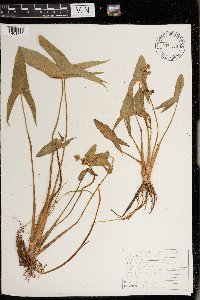 Sagittaria latifolia Willdenow 978970[1401879]Don Henson 6201974-07-18 United States, Michigan, Schoolcraft, E1/2 NE1/4 SW1/4 Sec 12 T41N-R16W, 45.96037 -86.25347 |
MIN:Plants | Sagittaria latifolia Willdenow 977287[1402871]Lee, Michael MDL67222014-08-31 United States, Minnesota, Lake, Boundary Waters Canoe Area Wilderness. Rolling to quite rugged bedrock terrain 12 miles north-northeast of Ely, along the flowage between Horse and Fourtown Lakes., 48.07228003794 -91.7832164606, 99m |
MIN:Plants | Sagittaria rigida Pursh 567931[]Scott, P. 16042003-08-21 United States, Minnesota, Saint Louis, ST. LOUIS CO ... Loon Lake, BWCAW. T67N R15W sec.27 NWNWNW.;Boundary Waters Canoe Area Wilderness / Superior National Forest;067N;15W;27, 48.259541 -92.246622 |
MIN:Plants | Sagittaria rigida Pursh 477732[]Kaul, R. 21391962-07-00 United States, Minnesota, Washington, Washington County ... 2 mi. S.E. of Oneka Lake ... T31N R21W;;031N;21W;00, 45.16836 -92.96519 |
MIN:Plants | Sagittaria rigida Pursh 459829[]Homoya, M.; et al. 15982003-08-20 United States, Minnesota, Saint Louis, ST. LOUIS CO ... South Lake at portage to Section 3 Pond, BWCAW. T67N R15W sec.3 NESENW.;Boundary Waters Canoe Area Wilderness / Superior National Forest;067N;15W;03, 48.317752 -92.247079 |
MIN:Plants | Sagittaria rigida Pursh 917123[]Smith, Welby; et al. 314622009-09-11 United States, Minnesota, Cook, Boundary Waters Canoe Area Wilderness / Superior National Forest. Cook County...Boundary Waters Canoe Area Wilderness, Superior National Forest. Along the Royal River...T64N R3E NW1/4 of NE1/4 of Sec 3. 064N 03E 3, 48.0619444 -90.0413889 |
MIN:Plants | Sagittaria rigida Pursh 477729[]Kaul, R. 21391962-07-00 United States, Minnesota, Washington, Washington County ... 2 mi. S.E. of Oneka Lake ... T31N R21W;;0031N;21W;00, 45.16836 -92.96519 |
MIN:Plants | Sagittaria rigida Pursh 429719[]Myhre, K. 69171997-07-17 United States, Minnesota, Carlton, Carlton Co.; Merwin Lake. Located 3 miles southeast of the town of Cromwell. Plants occur along the northwest end near inlet; T 48n R 20W NE1/4 of SE1/4 of Sec 15. 048N 20W 15, 46.643555 -92.861456 |
MIN:Plants | Sagittaria rigida Pursh 430216[]Lee, Michael MDL19381997-09-05 United States, Minnesota, Stearns, Stearns Co.; Six miles southwest of Grey Eagle; T126N R33W NW1/4 of NE1/4 Sec. 4;;126N;33W;4, 45.752587 -94.839913 |
MIN:Plants | Sagittaria rigida Pursh 507967[]Gerdes, Lynden 29591998-07-17 United States, Minnesota, Cook, Boundary Waters Canoe Area Wilderness / Superior National Forest. T64N R03E S03NWNE. Cook County; Superior National Forest, BWCAW. East of portage between John Lake and the Royal River. Along the banks and shallows of the Royal River.. 064N 03E 3, 48.057476 -90.04601 |
MIN:Plants | Sagittaria rigida Pursh 492617[]Kaul, R.; et al. 62091988-08-06 United States, Minnesota, Rice, Rice County ... Kelly Lake;;110N;21W;23, 44.351051 -93.37097 |
MIN:Plants | Sagittaria rigida Pursh 896950[]Rowe, Erika ERR20060830012006-08-30 United States, Minnesota, Becker, White Earth Indian Reservation. Becker County...Island/peninsula in the middle of the southern half of Big Sugar Bush Lake and adjacent to the WMA of the same name. 1.5 miles west of Hwy 34...SWSE S8 T141N R40W. 141N 40W 8, 47.0444444 -95.7713889 |
MIN:Plants | Sagittaria rigida Pursh 477555[]Lee, Michael MDL39991996-09-06 United States, Minnesota, Mille Lacs, Mille Lacs Kathio State Park. Mille Lacs County ... Mille Lacs Kathio State Park ... margins of Black Bass Lake 4 1/2 miles WNW of Onamia ... T42N R27W SE1/4 Sec. 11; SW1/4 Sec. 12; NW1/4 Sec. 13; NE1/4 Sec. 14. 042N 27W 11, 46.126998 -93.704923 |
MIN:Plants | Sagittaria rigida Pursh 477730[]Kaul, R. 2463A1977-06-11 United States, Minnesota, Rice, Rice County ... Southeast shore of Lake Mazaska;;110N;21W;, 44.363278 -93.385945 |
MIN:Plants | Sagittaria rigida Pursh 62110[]Burglehaus, F. s.n.1893-08-00 United States, Wyoming, Park, Near Mamouth Hot Springs;Yellowstone National Park, 2134m |
MIN:Plants | Sagittaria rigida Pursh 220924[]Rosendahl, C. 47211924-07-23 United States, Minnesota, Becker, De Soto Lake, Itasca State Park.;Itasca State Park;142N;36W;, 47.149912 -95.224954 |
MIN:Plants | Sagittaria rigida Pursh 221520[]Sheldon, Edmund S32111892-07-00 United States, Minnesota, Mille Lacs, Milaca.;;037N;27W;, 45.692047 -93.698793 |
MIN:Plants | Sagittaria rigida Pursh 221553[]Sheldon, Edmund S31491892-07-00 United States, Minnesota, Kanabec, Mora, Kanabec Co.;;039N;24W;, 45.860683 -93.327529 |
MIN:Plants | Sagittaria rigida Pursh 221556[]Taylor, B. T4441891-06-00 United States, Minnesota, Waseca, Lake Helena, Waseca Co.;;108N;23W;, 44.077041 -93.508384 |
Google Map
Google Maps is a web mapping service provided by Google that features a map that users can pan (by dragging the mouse) and zoom (by using the mouse wheel). Collection points are displayed as colored markers that when clicked on, displays the full information for that collection. When multiple species are queried (separated by semi-colons), different colored markers denote each individual species.