University of Minnesota
http://www.umn.edu/
612-625-5000
http://www.umn.edu/
612-625-5000
Minnesota Biodiversity Atlas
Bell Museum
Dataset: MIN-Plants
Taxa: Onagraceae
Search Criteria: excluding cultivated/captive occurrences
Bell Museum plants | |
 MIN:Plants |  Epilobium coloratum Biehler 772589[1137400]Boe, J. 13931979-08-08 United States, Minnesota, Lake of the Woods, Near Hwy. 72. 2.1 mi. N of co. line. W1/2 Sec. 19, R30W, T157N.;;157N;30W;19, 48.4035221 -94.5485174 |
MIN:Plants |  Epilobium coloratum Biehler 772680[1137402]Boe, J. 16181979-08-15 United States, Minnesota, Lake of the Woods, Wheeler's Point. Near shore of Lake of the Woods. T162N, R32W, NE1/4 Sec. 24.;;162N;32W;24, 48.8377135 -94.7080128 |
MIN:Plants |  Epilobium coloratum Biehler 772690[1137399]Boe, J. 15821979-08-15 United States, Minnesota, Lake of the Woods, Lake of the Woods Co.; Morris Point Sandbar. T162N, R32W, Sec. 16. Morris Point Sandbar. T162N, R32W, Sec. 16.. 162N 32W 16, 48.8516383 -94.7732985 |
MIN:Plants |  Epilobium coloratum Biehler 778072[1137338]Duxbury, Alexis 24571983-09-05 United States, Minnesota, Nobles, Compass Prairie: part of SE1/4 SW1/4 Sec. 3; T101N, R41W.;Compass Prairie Scientific Natural Area;101N;41W;3, 43.5801077 -95.7438528 |
MIN:Plants |  Epilobium coloratum Biehler 816659[1137312]Welling, C. 90-1051990-08-28 United States, Minnesota, Ramsey, Immediately N of Minnesota State Hwy. 96 and 0.6 km E of Hwy. 61, Sec. 12, of White Bear Twp. Ramsey Co.;;030N;22W;12, 45.1010813 -92.99472 |
MIN:Plants |  Epilobium coloratum Biehler 816962[1137407]Delaney, B. 893281989-09-05 United States, Minnesota, Sherburne, 2.2 mi. E of Lake Fremont. SW1/4 NE1/4 Sec. 12, T34W, R26W.;;034N;26W;12, 45.4507112 -93.5208786 |
MIN:Plants |  Epilobium coloratum Biehler 818089[1137366]Engels, A.; et al. s.n.1991-07-22 United States, Minnesota, Aitkin, Aitkin Co. T50N, R24W, Sec. 13 SW1/4 NW1/4. Ca. 4 mi. N of Libby on Hwy. 65.;;050N;24W;13, 46.8186209 -93.3265357 |
MIN:Plants |  Epilobium coloratum Biehler 832154[1137367]Morley, T. 17251992-08-08 United States, Minnesota, Dakota, Dakota Co.; W side of a drainage way; T114N, R20W, NE1/4 NE1/4 sec.13, Lakeville Twp.;;114N;20W;13, 44.6814128 -93.1666649 |
MIN:Plants |  Epilobium coloratum Biehler 425340[1137369]Mason, Harriet; et al. NSP98-1131998-08-25 United States, Minnesota, Rice, SW corner of sec. 16 in Nerstrand Big Woods State Park. East of snowmobile entrance just as drops down.;Nerstrand Woods State Park;110N;19W;16, 44.334371 -93.1112031 |
MIN:Plants |  Epilobium coloratum Biehler 484933[1137405]Ownbey, Gerald 58131977-08-17 United States, Minnesota, Hubbard, Itasca State Park. Hubbard Co.; T 143 N, R 35 W, Sect. 6, NW 1/4. S side of No Name Road (N. Boundary Road, Itasca State Park) just E of where it crosses Minn. Rte. 200. 143N 35W 6, 47.232454 -95.1613864 |
MIN:Plants |  Epilobium coloratum Biehler 907664[1137371]Lee, Michael; et al. MDL38282004-08-24 United States, Minnesota, Todd, Along the Long Prairie River, five miles north-northeast of Browerville. W1/2 of NE1/4 of NE1/4 Sec.;;131N;33W;22, 46.1431413 -94.8233224 |
MIN:Plants |  Epilobium coloratum Biehler 425334[1137318]Mason, Harriet; et al. NSP98-1101998-08-25 United States, Minnesota, Rice, SW corner of sec. 16 in Nerstrand Big Woods State Park. North of planted prairie, along clearing edge;Nerstrand Woods State Park;110N;19W;16, 44.334371 -93.1112031 |
MIN:Plants |  Epilobium coloratum Biehler 436882[1137368]Juhnke, C. 499 CMJ FRO1999-07-29 United States, Minnesota, Goodhue, Frontenac State Park Goodhue County ... On down-river side of Willow Point ... T112N R13W SW NW SE 12;Frontenac State Park;112N;13W;12, 44.5198223 -92.3191229 |
MIN:Plants |  Epilobium coloratum Biehler 432060[1137404]Ownbey, Gerald; et al. 53721976-08-27 United States, Minnesota, Houston, Houston Co.; 2.5 miles S of Root River bridge on Rte. 26.;Dorer Memorial Hardwood State Forest;103N;04W;, 43.7185403 -91.3173949 |
MIN:Plants |  Epilobium coloratum Biehler 497745[1137406]Ownbey, Gerald 54351976-08-29 United States, Minnesota, Washington, along Trout Brook W of its confluence with the St. Croix River. NW1/4 of section;Afton State Park;027N;20W;02, 44.8547629 -92.7750459 |
MIN:Plants |  Epilobium coloratum Biehler 923766[1137373]Anderson, Derek 13852009-08-26 United States, Minnesota, Dodge, About 8.5 km northeast of Hayfield. NWSE of section;Vernon Wildlife Management Area;105N;16W;09, 43.9113967 -92.7442908 |
MIN:Plants |  Epilobium coloratum Biehler 921833[1137372]Smith, Welby 235151993-08-11 United States, Minnesota, Isanti, Lyndon Cedarglade Park, about 13 miles southwest of Cambridge...T34N R25W NW1/4 of SW1/4 of Sec 13;Lyndon Cedarglade County Park;034N;25W;13, 45.4377778 -93.4075 |
MIN:Plants |  Epilobium coloratum Biehler 938162[1137323]Anderson, Derek 10732008-08-16 United States, Minnesota, Mower, about 4km NE of Grand Meadow. Access from County Rd 16 (4.4 km east of Grand Meadow), follow easement north 800m than west 400 m to enter SE corner of WMA. SE1/4 SW1/4 of section.;Deer Creek Wildlife Management Area;103N;14W;16, 43.7197736 -92.5219081 |
MIN:Plants |  Epilobium coloratum Biehler 938163[1137324]Anderson, Derek 10362008-08-27 United States, Minnesota, Mower, about 5km SSW of Stewartville. NW1/4 NW1/4 of section.;;104N;14W;16, 43.81834 -92.5258086 |
MIN:Plants |  Epilobium coloratum Biehler 361099[1196254]Hayden, A. 348 United States, Iowa, Winneshiek |
MIN:Plants | 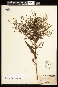 Epilobium coloratum Biehler 160191[1196255]Wilkinson, E. 33811 United States, Ohio, Richland |
MIN:Plants | 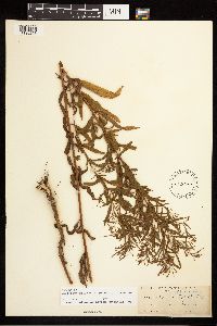 Epilobium coloratum Biehler 160199[1196256]Moffatt, W. S. 470 United States, Illinois, Cook |
MIN:Plants | 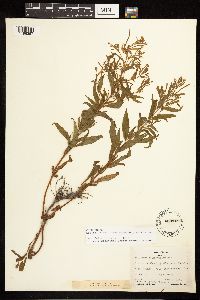 Epilobium coloratum Biehler 458119[1196257]Horr, W. H. 4107 United States, Kansas, Meade |
MIN:Plants | 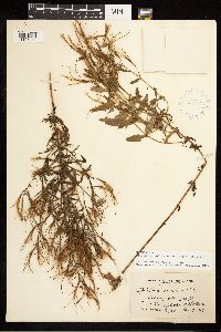 Epilobium coloratum Biehler 415800[1196258]Berkheimer, D. 4408 United States, Pennsylvania, Berks |
MIN:Plants |  Epilobium coloratum Biehler 420228[1196259]Tryon, R. M. 2201 United States, Indiana, Porter |
MIN:Plants |  Epilobium coloratum Biehler 549306[1196260]Umbach, L.M. 6774 United States, Indiana, Morgan, Along river, Miller's |
MIN:Plants |  Epilobium coloratum Biehler 571995[1196261]Cooperrider, T. S. 3199 United States, Iowa, Clinton |
MIN:Plants |  Epilobium coloratum Biehler 361596[1196262]Hayden, A. 10098 United States, Iowa, Palo Alto |
MIN:Plants |  Epilobium coloratum Biehler 590806[1196263]Mohlenbrock, R. 475 United States, Illinois, Jackson |
MIN:Plants |  Epilobium coloratum Biehler 334434[1196264]Kildahl, N. J. s.n. United States, North Dakota, Grand Forks |
MIN:Plants |  Epilobium coloratum Biehler 378503[1196265]Jones, G. N. 15450 United States, Massachusetts, Berkshire |
MIN:Plants |  Epilobium coloratum Biehler 160203[1196266]Kearney, T. H. 519 United States, Kentucky, Bell |
MIN:Plants | 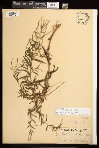 Epilobium coloratum Biehler 160193[1196267]Kearney, T. H. 722 United States, Tennessee, Cocke |
MIN:Plants | 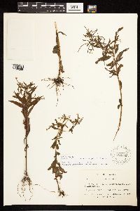 Epilobium coloratum Biehler 622701[1196268]Gilbert 267 Canada, Quebec, Huntingdon |
MIN:Plants | 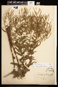 Epilobium coloratum Biehler 160198[1196269]Steele, E. S. s.n. United States, District of Columbia |
MIN:Plants | 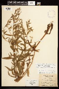 Epilobium coloratum Biehler 395752[1196270]Wadmond, S. C. 17439 United States, Wisconsin, Walworth |
MIN:Plants |  Epilobium coloratum Biehler 524540[1196271]Benner, F. R. 363 United States, Wisconsin, Polk |
MIN:Plants |  Epilobium coloratum Biehler 525228[1196272]Twing, H. N. s.n. United States, Maryland, Garrett |
MIN:Plants |  Epilobium coloratum Biehler 160204[1196273]Bates, J. M. 4748 United States, Nebraska, Franklin |
MIN:Plants |  Epilobium coloratum Biehler 400014[1196274]Fitzpatrick, T. J. s.n. United States, Iowa, Johnson |
MIN:Plants |  Epilobium coloratum Biehler 398875[1196275]Shimek, B. s.n. United States, Iowa, Dickinson |
MIN:Plants |  Epilobium coloratum Biehler 301359[1196276]Keinholz, R. 228 United States, South Dakota, Roberts |
MIN:Plants |  Epilobium coloratum Biehler 256129[1196277]Biltmore Herbarium 424d United States, Kentucky |
MIN:Plants |  Epilobium coloratum Biehler 160197[1196278]Umbach, L.M. s.n. United States, Indiana, Lake, Miller's |
MIN:Plants | 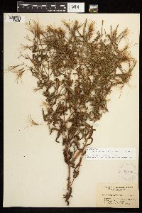 Epilobium coloratum Biehler 351906[1196279]Williams, L. G. 648 United States, West Virginia, Cabell |
MIN:Plants | 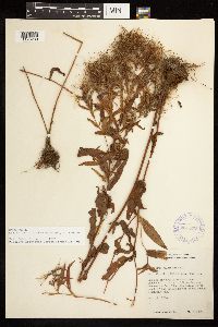 Epilobium coloratum Biehler 361599[1196280]Hayden, A. 10099 United States, Iowa, Palo Alto |
MIN:Plants | 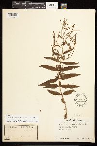 Epilobium coloratum Biehler 564555[1196281]Harris, M. E. s.n. United States, Massachusetts, Hampshire |
MIN:Plants | 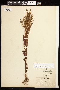 Epilobium coloratum Biehler 160202[1196282]Fernald, M. L. 17207 United States, Massachusetts, Barnstable |
MIN:Plants | 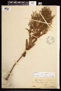 Epilobium coloratum Biehler 159918[1196283]Bates, J. M. s.n. United States, Nebraska |
MIN:Plants | 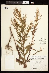 Epilobium coloratum Biehler 600550[1196284]Bozeman, J. R. 7782 United States, North Carolina, Macon |
MIN:Plants | 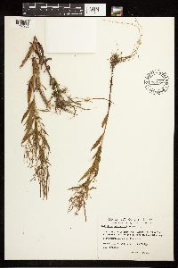 Epilobium coloratum Biehler 702353[1196285]Brisson, S. 77833 Canada, Quebec |
MIN:Plants | 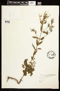 Epilobium coloratum Biehler 716199[1196286]Gable, J. s.n. United States, West Virginia, Tucker |
MIN:Plants | 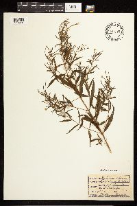 Epilobium coloratum Biehler 716374[1196287]Music, D. J. s.n. United States, West Virginia, McDowell |
MIN:Plants | 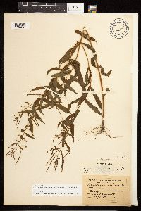 Epilobium coloratum Biehler 160189[1196288]Morris, E. L. s.n. United States, Massachusetts, Hampden |
MIN:Plants | 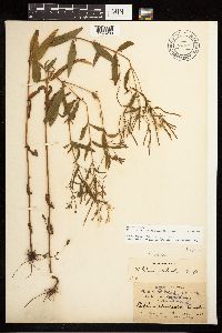 Epilobium coloratum Biehler 160187[1196289]Dodge, C. K. s.n. United States, Michigan, Saint Clair |
MIN:Plants | 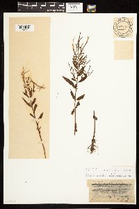 Epilobium coloratum Biehler 160183[1196290]Manning, W. H. s.n. United States |
MIN:Plants | 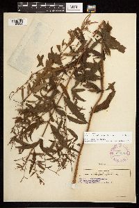 Epilobium coloratum Biehler 278899[1196291]Carpenter, D. S. s.n. United States, Vermont, Rutland |
MIN:Plants | 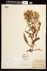 Epilobium coloratum Biehler 487112[1196292]Faxon, E. 20 United States, Massachusetts, Suffolk |
MIN:Plants | 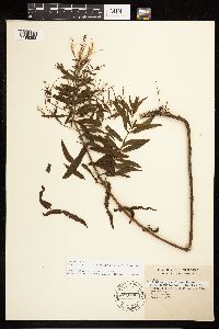 Epilobium coloratum Biehler 599190[1196293]Tryon, R. M. 1836 United States, Indiana, Porter |
MIN:Plants | 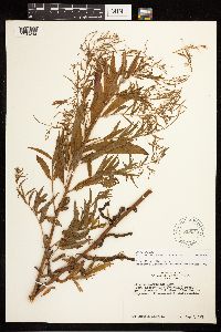 Epilobium coloratum Biehler 619024[1196294]Albright, D. 213 United States, Ohio, Ottawa |
MIN:Plants |  Epilobium coloratum Biehler 301681[1196295]Bright, J. 7233 United States, Pennsylvania, Fayette |
MIN:Plants |  Epilobium coloratum Biehler 523449[1196296]Cooper, W. S. s.n. United States, Michigan, Saint Clair |
MIN:Plants |  Epilobium coloratum Biehler 763780[1196297]Lugger, O. s.n. Canada, Newfoundland and Labrador |
MIN:Plants |  Epilobium coloratum Biehler 763827[1196298]Burglehaus, F. H. s.n. United States, Wisconsin, Polk |
MIN:Plants |  Epilobium coloratum Biehler 480293[1196299]Russell, N. H. NR 828528 United States, Iowa, Poweshiek |
MIN:Plants |  Epilobium coloratum Biehler 358184[1196300]Veerhoff, O. 135 United States, North Carolina, Iredell |
MIN:Plants |  Epilobium coloratum Biehler 293245[1196301]Haught, O. s.n. United States, West Virginia, Wetzel |
MIN:Plants |  Epilobium coloratum Biehler 593454[1196302]Hartley, T. G. 5217 United States, Wisconsin, Buffalo |
MIN:Plants |  Epilobium coloratum Biehler 160196[1196303]Ashcroft, G. B. s.n. United States, Ohio, Cuyahoga |
MIN:Plants |  Epilobium coloratum Biehler 541875[1196304]Bennett, H. R. s.n. United States, Indiana, Porter |
MIN:Plants |  Epilobium coloratum Biehler 398837[1196305]Shimek, B. s.n. United States, Iowa, Johnson |
MIN:Plants |  Epilobium coloratum Biehler 545279[1196306]Daubenmire, R. F. s.n. United States, Indiana, Parke |
MIN:Plants | 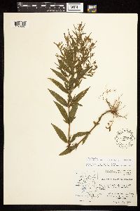 Epilobium coloratum Biehler 593538[1196307]Hartley, T. G. 8719 United States, Iowa, Allamakee |
MIN:Plants | 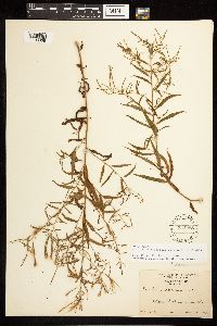 Epilobium coloratum Biehler 534988[1196308]Jones, G. N. 20207 United States, Illinois, Piatt |
MIN:Plants | 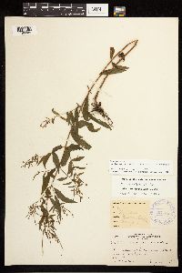 Epilobium coloratum Biehler 367185[1196309]Koelnau, L. A. 84 United States, Wisconsin, Polk |
MIN:Plants | 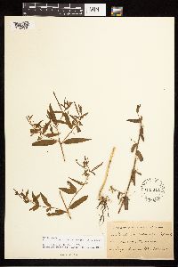 Epilobium coloratum Biehler 160200[1196310]Seigerist, W. s.n. United States, Nebraska, Saline |
MIN:Plants |  Epilobium coloratum Biehler 581959[1196311]Gates, B. N. s.n. United States, Massachusetts, Worcester |
MIN:Plants |  Epilobium coloratum Biehler 571803[1196312]Cooperrider, T. S. 3235 United States, Iowa, Clinton |
MIN:Plants |  Epilobium coloratum Biehler 400007[1196313]Chase, A. s.n. United States, Indiana, Morgan |
MIN:Plants |  Epilobium coloratum Biehler 160201[1196314]Fink, B. s.n. United States, Iowa, Fayette |
MIN:Plants | 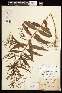 Epilobium coloratum Biehler 400012[1196315]Wadmond, S. C. 3231 United States, Wisconsin, Racine |
MIN:Plants | 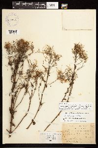 Epilobium coloratum Biehler 399968[1196316]Wadmond, S. C. 868 United States, Wisconsin, Racine |
MIN:Plants | 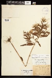 Epilobium coloratum Biehler 400008[1196317]Wadmond, S. C. 868 United States, Wisconsin, Kenosha |
MIN:Plants | 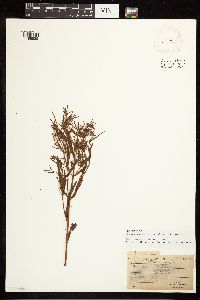 Epilobium coloratum Biehler 567950[1196935]Manning, W. H. 902 United States, Massachusetts, Middlesex |
MIN:Plants |  Epilobium coloratum Biehler 964096[1375069]Stork, H.E. s.n.1925-00-00 United States, Minnesota, Itasca, Bowstring |
MIN:Plants |  Epilobium coloratum Biehler 964115[1375087] United States, Iowa |
MIN:Plants |  Epilobium coloratum Biehler 964110[1375092] United States, Iowa |
MIN:Plants |  Epilobium coloratum Biehler 966991[1359664]Dahlberg, Nathan B. NBD2202019-09-05 United States, Minnesota, Koochiching, Koochiching State Forest 151m N of Forest Service Rd, 2653m W of UT-3171, 20.62 miles from Littlefork;, 48.31 -93.13 |
MIN:Plants |  Epilobium coloratum Biehler 969085[1391752]Rowe, Erika R. ERR9422016-08-24 United States, Minnesota, Lake of the Woods, Northwest Angle. 0.75 miles west of Lake of the Woods shoreline; 3 miles southeast of Young's Bay Marina., 49.31 -94.95 |
MIN:Plants |  Epilobium coloratum Biehler 969682[1371271]B. Bartodziej 2-00 B2000-08-01 United States, Minnesota, Ramsey, Subwatershed Num.: NB 18-03, 45.042807 -92.98961 |
MIN:Plants |  Epilobium coloratum Biehler 975832[1404825]Dunevitz, Hannah L. 3521990-09-26 United States, Minnesota, Rice, Part of a large wetland expanse on the east side of the Cannon River about one mile south of Northfield., 44.41 -93.2 |
MIN:Plants |  Epilobium glandulosum Lehman 461262[1137410]Gerdes, Lynden; Gerdes, D. Lawson 29161998-07-11 United States, Minnesota, Cook, Approx. .75 miles ENE of Mayhew Lake near hiking trail to Hoat Lake. Pond/drainage area north of trail. SWSW of sec.;Boundary Waters Canoe Area Wilderness / Superior National Forest;065N;02W;26, 48.0842678 -90.5441204 |
MIN:Plants |  Epilobium glandulosum Lehman 920567[1137431]Smith, Welby 200561991-08-26 United States, Minnesota, Morrison, At the west end of Hole in Day Marsh, just south and east of the junction of Cunningham Road and Bennet Road. UTM: 391500E 5110000N. NE1/4 of NW1/4 of Sec.;Camp Ripley Military Reservation;131N;30W;25, 46.134945 -94.4046478 |
MIN:Plants |  Epilobium glandulosum Lehman 428322[1137421]Smith, Welby 139301987-09-01 United States, Minnesota, Scott, Murphy-Hanrahan County Park Reserve. Scott County ... Murphy-Hanrahan Regional Park, on the S side of Hanrahan Lake, about 2 mi W of Burnsville; SW1/4 NW1/4 sec.34, T115N R21W. 115N 21W 34, 44.7277794 -93.3363876 |
MIN:Plants |  Epilobium glandulosum Lehman 430346[1137415]Mensing, D. 95-2131995-08-29 United States, Minnesota, Morrison, Morrison Co.; T39N R31W SE1/4 of the NE1/4 of S4; Buckman Creek;;039N;31W;4, 45.9042322 -94.20949 |
MIN:Plants |  Epilobium glandulosum Lehman 430563[1137416]Dana, R. 920931992-08-07 United States, Minnesota, Kittson, Kittson Co.; at base of Glacial Lake Agassiz beach ridge; T 159N R 45W SE1/4 of SW1/4 of Sec 5;;159N;45W;5, 48.6227232 -96.4865479 |
MIN:Plants |  Epilobium glandulosum Lehman 434841[1137413]Dana, R. 920931992-08-07 United States, Minnesota, Kittson, Kittson Co.; at base of Glacial Lake Agassiz beach ridge; T 159N R 45W SE1/4 of SW1/4 of Sec 5;;159N;45W;5, 48.6227232 -96.4865479 |
MIN:Plants |  Epilobium glandulosum Lehman 439098[1137419]Myhre, K.M. 26401992-07-09 United States, Minnesota, Cass, Located on the southeast shore of Moccasin Lake; T 141N R 29W NW1/4 of NW1/4 of Sec 33 [Chippewa National Forest], 46.9864071 -94.3557313 |
MIN:Plants |  Epilobium glandulosum Lehman 439940[1137411]Smith, Welby 164431989-09-06 United States, Minnesota, Benton, On the Platte River about 1.5 mi N of its confluence with the Mississippi River, and about 1.5 mi S of Royalton. SE1/4 NW1/4 sec.;;038N;32W;11, 45.8011093 -94.2916641 |
MIN:Plants |  Epilobium glandulosum Lehman 440729[1137429]Smith, Welby 149951988-08-30 United States, Minnesota, Washington, Washington County ... About 2 mi NE of Stillwater ... W bank of the St. Croix River ... NE1/4 NW1/4 sec.14, T30N R20W;Saint Croix National Riverway;030N;20W;14, 45.0922241 -92.7763901 |
Google Map
Google Maps is a web mapping service provided by Google that features a map that users can pan (by dragging the mouse) and zoom (by using the mouse wheel). Collection points are displayed as colored markers that when clicked on, displays the full information for that collection. When multiple species are queried (separated by semi-colons), different colored markers denote each individual species.