University of Minnesota
http://www.umn.edu/
612-625-5000
http://www.umn.edu/
612-625-5000
Minnesota Biodiversity Atlas
Bell Museum
Dataset: MIN-Plants
Taxa: Onagraceae
Search Criteria: excluding cultivated/captive occurrences
Bell Museum plants | |
 MIN:Plants |  Epilobium glandulosum Lehman 440729[1137429]Smith, Welby 149951988-08-30 United States, Minnesota, Washington, Washington County ... About 2 mi NE of Stillwater ... W bank of the St. Croix River ... NE1/4 NW1/4 sec.14, T30N R20W;Saint Croix National Riverway;030N;20W;14, 45.0922241 -92.7763901 |
MIN:Plants |  Epilobium glandulosum Lehman 440816[1137424]Smith, Welby 138491987-08-13 United States, Minnesota, Washington, Washington Co. Corries Swamp, about 8 mi NW of Marine on St. Croix; NW1/4 NE1/4 sec.35, T32N R21W;;032N;21W;35, 45.2176341 -92.92766 |
MIN:Plants |  Epilobium glandulosum Lehman 457118[1137425]Smith, Welby 136721987-07-31 United States, Minnesota, Washington, Washington Co. About 2 mi S of St. Paul Park. NE1/4 SE1/4 sec 23, T27W R22W;;027N;22W;23, 45.2171528 -92.7641397 |
MIN:Plants |  Epilobium glandulosum Lehman 464310[1137417]Gerdes, Lynden 28551998-07-06 United States, Minnesota, Cook, Boundary Waters Canoe Area Wilderness / Superior National Forest. T65N R02E S26SWNW. Cook Co.; Superior National Forest, BWCAW. Wetland complex ~ .25 miles NE of the far NE corner of Wes T65N R02E S26SWNW. Cook Co.; Superior National Forest, BWCAW. Wetland complex ~ .25 miles NE of the far NE corner of West Pike Lake.. 065N 02E 26, 48.0855741 -90.1548253 |
MIN:Plants | Epilobium glandulosum Lehman 473831[]Myhre, K. 52301994-07-27 United States, Minnesota, Itasca, Itasca Co.; Located 1.2 miles south of Gunderson Lake; Little Round Lake; T 60N R 25W SE1/4 of SE1/4 of Sec 25;George Washington State Forest;060N;25W;25, 47.6514512 -93.4595421 |
MIN:Plants |  Epilobium glandulosum Lehman 590654[1137427]Myhre, K. 60331995-08-08 United States, Minnesota, Crow Wing, Crow Wing Co.; Located 6 miles south of the town of Crosby; northeast bay of Nokay Lake; T 45N R 29W NW1/4 of NW1/4 of S Crow Wing Co.; Located 6 miles south of the town of Crosby; northeast bay of Nokay Lake; T 45N R 29W NW1/4 of NW1/4 of Sec 13. 045N 29W 13, 46.3808592 -93.9470808 |
MIN:Plants |  Epilobium glandulosum Lehman 616074[1137428]Myhre, K. 62291995-09-01 United States, Minnesota, Aitkin, Rice Lake National Wildlife Refuge. Aitkin Co.; Located one mile northeast of Rice Lake in Rice Lake Wildlife Refuge. Plants occur along the south shore of Aitkin Co.; Located one mile northeast of Rice Lake in Rice Lake Wildlife Refuge. Plants occur along the south shore of Mandy Lake; T 47N R 24W NE1/4 of SW1/4 of Sec 23. 047N 24W 23, 46.5410803 -93.337739 |
MIN:Plants |  Epilobium glandulosum Lehman 698773[1137445]Sather, Nancy; et al. 3471976-08-25 United States, Minnesota, Lake, Lake Co. NE1/4 NE1/4 Sec. 17, T61N, R9W;Superior National Forest;061N;09W;17, 47.7660369 -91.5019037 |
MIN:Plants |  Epilobium glandulosum Lehman 698925[1137437]Sather, Nancy; et al. 5381977-08-25 United States, Minnesota, Saint Louis, St. Louis Co. ...USFS 1822 just W of jct. with USFS 130. SE1/4 Sec. 7, T57N, R14W.;Superior National Forest;057N;14W;07, 47.4367952 -92.165649 |
MIN:Plants |  Epilobium glandulosum Lehman 698926[1137435]Sather, Nancy; et al. 3351976-08-03 United States, Minnesota, Saint Louis, St. Louis Co. USFS 420 just E of Cranberry Creek. W1/2 SE1/4 Sec. 10, T58N, R13W;Superior National Forest;058N;13W;10, 47.5246993 -91.973025 |
MIN:Plants |  Epilobium glandulosum Lehman 700824[1137441]Dorio, J. 7611977-08-10 United States, Minnesota, Morrison, Lake Alexander, ca. 7 mi. N of Randall on Co. Rd. 6. T131N, R30W, Sec. 6.;;131N;30W;6, 46.1870677 -94.5062348 |
MIN:Plants |  Epilobium glandulosum Lehman 708406[1137438]Ownbey, Gerald 65551979-09-17 United States, Minnesota, Washington, Washington County ... T 30N, R 20W, Sec. 14, NW1/4. Along the St. Croix River, about 1.5 mi. north of Stillwater.;Saint Croix National Riverway;030N;20W;14, 45.0905152 -92.7773108 |
MIN:Plants |  Epilobium glandulosum Lehman 717545[1137446]Mathisen, Ron 1291979-07-20 United States, Minnesota, Hubbard, Spearhead Lake Preserve;Spearhead Lake Preserve (Audubon);145N;34W;, 47.3680989 -94.9909661 |
MIN:Plants |  Epilobium glandulosum Lehman 717768[1137442]Thompson, J. s.n.1979-08-01 United States, Minnesota, Mahnomen, 4 mi. W of Waubun;White Earth Indian Reservation;143N;42W;, 47.1950895 -96.0000303 |
MIN:Plants |  Epilobium glandulosum Lehman 717815[1137434]Lustig, K. 2061978-08-04 United States, Minnesota, Beltrami, Upper Red Lake, eastern shore. T154N, R30W, Sec. 18. Near picnic grounds.;Red Lake Indian Reservation;154N;30W;18, 48.156613 -94.5424693 |
MIN:Plants |  Epilobium glandulosum Lehman 717855[1137439]Lustig, K. 331977-08-11 United States, Minnesota, Ramsey, Lake Wabasso, S side of lake. On Hwy. 18 (North Owasso Blvd.) T30N, R22W, Sec. 36.;;030N;22W;36, 45.0429889 -92.9948466 |
MIN:Plants |  Epilobium glandulosum Lehman 722842[1137447]Lustig, K. 7601979-07-18 United States, Minnesota, Anoka, Anoka County...Boot Lake SNA: 17 mi. SE of Cambridge, Sec. 17, 18, 19, 20, T33N, R22W;Boot Lake Scientific Natural Area;033N;22W;00, 45.3406583 -93.0814633 |
MIN:Plants | 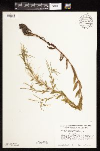 Epilobium glandulosum Lehman 724808[1137444]Smith, Welby 12171979-08-13 United States, Minnesota, Wright, Wright Co.; T112N, R27W, SW1/4 NE1/4 Sec. 12. On the N side of Co. Rd. 75, ca. 2.2 mi. SE of its jct. with Hwy. 24 in C Wright Co.; T112N, R27W, SW1/4 NE1/4 Sec. 12. On the N side of Co. Rd. 75, ca. 2.2 mi. SE of its jct. with Hwy. 24 in Clearwater.. 122N 27W 12, 45.3912293 -94.0245386 |
MIN:Plants | 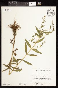 Epilobium glandulosum Lehman 730041[1137422]Converse, C. 5151980-07-22 United States, Minnesota, Pine, 5.5 mi E of Hinckley. SW1/4 NW1/4 of section;Kettle River Scientific Natural Area / Sandstone National Wildlife Refuge;041N;20W;23, 46.01861 -92.8358 |
MIN:Plants | Epilobium glandulosum Lehman 730274[]Converse, C. 6191980-08-15 United States, Minnesota, Chisago, Goose Creek Natural Area: 5 mi. SE of Rush City. SW1/4 SE1/4 Sec. 12.;Wild River State Park;036N;21W;12, 45.6225124 -92.9090537 |
MIN:Plants | 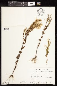 Epilobium glandulosum Lehman 734513[1137440]Petron, T. 414B1980-09-02 United States, Minnesota, Clay, Bluestem Prairie: 13 mi. E of Moorhead. SW1/4 SE1/4 Sec. 22, T139N, R46W.;Bluestem Prairie Scientific Natural Area;139N;46W;22, 46.8404624 -96.4734507 |
MIN:Plants | 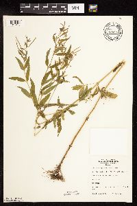 Epilobium glandulosum Lehman 738133[1137436]Lounsbury, S. 211977-08-12 United States, Minnesota, Saint Louis, St. Louis River Estuary, Waterfront Trail Area. Old marina by Tallus Island.;;049N;15W;26, 46.698204 -92.2087328 |
MIN:Plants |  Epilobium glandulosum Lehman 759017[1137423_1;1137423_2]Smith, Welby 70151982-07-30 United States, Minnesota, Mower, Brandt-Larson Wildlife Management Area. Brandt-Larson State Wildlife Management Area. Ca. 4 mi. NE of Lyle. Along Otter Creek. NE1/4 SW1/4 Sec. 16, T101N, R1 Brandt-Larson State Wildlife Management Area. Ca. 4 mi. NE of Lyle. Along Otter Creek. NE1/4 SW1/4 Sec. 16, T101N, R17W.. 101N 17W 16, 43.5507457 -92.8788352 |
MIN:Plants |  Epilobium glandulosum Lehman 759518[1137448]Morton, C. 79801951-09-08 United States, Minnesota, Lake, Kawishiwi National Forest;Boundary Waters Canoe Area Wilderness / Superior National Forest;N;;, 48.028382 -91.387532 |
MIN:Plants |  Epilobium glandulosum Lehman 762880[1137433]Anonymous 2021923-07-10 United States, Minnesota, Saint Louis, Duluth;;N;;, 46.783273 -92.106579 |
MIN:Plants |  Epilobium glandulosum Lehman 782546[1137426]Tenney, M. 5341982-08-16 United States, Minnesota, Winona, Whitewater State Park. Winona Co. T107N, R10W, Sec. 29, NE1/4 NW1/4 NE1/4;Whitewater State Park;107N;10W;29, 44.0420349 -92.0493334 |
MIN:Plants |  Epilobium glandulosum Lehman 815792[1137418]Wheeler, Gerald 112821988-07-22 United States, Minnesota, Lac Qui Parle, Ca. 5.5. mi. WSW of Madison; wildlife area E of Rte. 13. NW1/4 Sec. 33, T118N, R45W (Arena Twp.);;118N;45W;33, 44.986951 -96.299017 |
MIN:Plants |  Epilobium glandulosum Lehman 817797[1137420]Clem, K. 321890-08-29 United States, Minnesota, Anoka, Springbrook Nature Center, two mile trail. Between University Ave. and East River Road on 85th Ave, Fridley;;N;;, 45.122222 -93.275 |
MIN:Plants |  Epilobium glandulosum Lehman 818180[1137449]Engels, A.; et al. s.n.1991-06-12 United States, Minnesota, Aitkin, Aitkin Co. T48N, R27W, Sec. 10, SW1/4 SE1/4. N side of Blind Lake;;048N;27W;10, 46.6605537 -93.7507047 |
MIN:Plants |  Epilobium glandulosum Lehman 488349[1137430]Juhnke, C. 542 CMJ FRO1999-08-31 United States, Minnesota, Goodhue, north face of Rattlesnake Bluff. NW NW NE of sec.;Frontenac State Park;112N;13W;05, 44.5351964 -92.3999731 |
MIN:Plants |  Epilobium glandulosum Lehman 934268[1137432]Partch, M. s.n.1976-08-06 United States, Minnesota, Stearns, [no further data];Cold Spring Heron Colony Scientific Natural Area;123N;30W;13, 45.463971 -94.3943224 |
MIN:Plants |  Epilobium glandulosum Lehman 970874[1394342]Smith, Welby R WRS358132017-09-04 United States, Minnesota, Ramsey, On the east side of Sucker Lake in Shoreview., 45.072825 -93.0954861 |
MIN:Plants | 510404[]Gerdes, Lynden 30171998-07-22 United States, Minnesota, Cook, T65N R03W S32SWNE. Cook County ...Superior National Forest. Boat landing/public access area at far west end of Loon Lake;Superior National Forest;065N;03W;32, 48.0702856 -90.7406982 |
MIN:Plants | 476727[]Wheeler, Gerald 174091997-08-29 United States, Minnesota, Renville, Birch Coulee State Memorial Park. Renville County ... Ca. 1.5 mi. NE of Morton; S of Rte. 2; Birch Coulee State Memorial Park ... W of creek. NW1/4 NW1/4 Sec. 28 T113N R34W (Birch Cooley 28). 113N 34W 28, 44.5634035 -94.9442233 |
MIN:Plants | 509605[]Wheeler, Gerald 171551997-08-11 United States, Minnesota, Renville, Renville County ... Ca. 6.1 mi. SW of Sacred Heart ... S1/2 SW1/4 Sec. 18 T115N R38w (Hawk Creek 18);;115N;38W;18, 44.7671737 -95.4729259 |
MIN:Plants | 221594[]Sheldon, Edmund s.n.1895-06-00 United States, Minnesota, Hennepin, Ft. Snelling;Fort Snelling Military Reservation;N;;, 44.892682 -93.180268 |
MIN:Plants | 346734[]Lakela, Olga 21131937-08-01 United States, Minnesota, Saint Louis, jnc of Snively Boulevard and Jean Du Luth Road, Duluth;;;;, 46.840382 -92.051433 |
MIN:Plants | 427425[]Darveaux, B. s.n.1991-07-23 United States, Minnesota, Scott, Shakopee, Scott Co. Minnesota Valley Wildlife Refuge. Rt. 101 N.;Minnesota Valley National Wildlife Refuge;115N;23W;1, 44.7977388 -93.5304698 |
MIN:Plants | 440269[]Smith, Welby 149381988-08-23 United States, Minnesota, Houston, Houston Co. About 4 mi E-SE of Rushford; SW1/4 NW1/4 sec.27, T104N R7W;Dorer Memorial Hardwood State Forest;104N;07W;27, 43.7844429 -91.6694412 |
MIN:Plants | 484594[]Wheeler, Gerald 178211997-09-18 United States, Minnesota, Renville, Renville County ... Ca. 6 mi. SE of Franklin on Rte. 5, S of road, County Park No. 4 ... SW1/4 SE1/4 Sec. 34 T112N R33W;Renville County Park #4;112N;33W;34, 44.4598774 -94.7999076 |
MIN:Plants | 515959[]Smith, Welby 147821988-08-09 United States, Minnesota, Nobles, Nobels Co.; about 2 mi W-NW of Adrian; right-of-way of the C&NW Railroad. SW1/4 SW1/4 sec.11, T102N R43W;;102N;43W;11, 43.6524377 -95.9629307 |
MIN:Plants | 831356[]Cloutier, H. s.n.1943-07-20 United States, Minnesota, Itasca, Itasca Co, Coleraine, Trout Lake vicinity.;;N;;, 47.278 -93.422558 |
MIN:Plants | 833086[]Myhre, K. 28201992-07-23 United States, Minnesota, Cass, Cass Co. Located 1 mi S of Leech Lake; T141N R29W NE1/4 of NE1/4 of Sec 17;Chippewa National Forest / Leech Lake Indian Reservation;141N;29W;17, 47.0296351 -94.3753169 |
MIN:Plants | 511108[]Wheeler, Gerald 170541997-08-09 United States, Minnesota, Swift, Swift County ... Ca. 15 mi. E of Clontarf, E of Rte. 33 ... W1/2 NW1/4 NW1/4 Sec. 8 T122N R37W (Kerkhoven 8);;122N;37W;8, 45.3907458 -95.3475246 |
MIN:Plants | 515310[]Juhnke, C. 019 CMJ FRO1998-08-18 United States, Minnesota, Goodhue, Frontenac State Park Goodhue County ... East of contact station ...T112N R13W NE SE NW 11;Frontenac State Park;112N;13W;11, 44.5199905 -92.3392244 |
MIN:Plants | 485056[]Wheeler, Gerald 202511999-08-03 United States, Minnesota, Le Sueur, Le Sueur County ... Ca. 2 mi. NE of St. Peter on Rte. 23 ... N1/2 SW1/4 Sec. 14 T110N R26W;Ottawa Wildlife Management Area;110N;26W;14, 44.3338469 -93.9190813 |
MIN:Plants | 477321[]Cholewa, A. 26062002-07-22 United States, Minnesota, Anoka, Anoka County. Ham Lake County Park [now a city park], T32N R23W Sec 21, NW1/4.;;032N;23W;21, 45.1606199 -93.2973275 |
MIN:Plants | 511110[]Wheeler, Gerald 176691997-09-04 United States, Minnesota, Chippewa, Chippewa County ... Ca. 3 mi. NW of Granite Fallson Palmer Creek road ... NW1/4 NE1/4 SE1/4 Sec. 20 T116N R39W;;116N;39W;20, 44.836485 -95.5769896 |
MIN:Plants | 896842[]Haferman, J. 2801996-08-10 United States, Minnesota, Scott, Approx. 0.1 miles NNE of intersection of State Highway 13 and County Road 44 on N side of highway. SW1/4 of SW1/4 of section.;;115N;22W;36, 44.72459 -93.40903 |
MIN:Plants | 511540[]Wheeler, Gerald 169501997-08-07 United States, Minnesota, Swift, Swift County ... Ca. 9 mi. N of Murdock on Rte. 33, W of road ... NE1/4 NW1/4 Sec. 30 T122N R37W (Kerkhoven 30);;122N;37W;30, 45.3473111 -95.3680951 |
MIN:Plants | 911916[]Chayka, K. KC-09012009-08-06 United States, Minnesota, Ramsey, Ramsey County...Long Lake Regional Park, New Brighton; prairie area adjacent to the train depot parking lot;Long Lake County Park;030N;23W;20, 45.0791667 -93.196 |
MIN:Plants | 922595[]Smith, Welby 234351993-08-10 United States, Minnesota, Brown, Cottonwood River Prairie Scientific Natural Area. Cottonwood River Prairie State Scientific and Natural Area, about 5 miles south of Springfield... T 109N R35W NW1/4 of SW1/4 of Sec 33. 109N 35W 35, 44.2005556 -95.0647222 |
MIN:Plants | 921489[]Smith, Welby 236361993-08-13 United States, Minnesota, Meeker, South of Highway 12, on the west side of Grove City...T 119N R 32W SE1/4 of NW1/4 of sec 3;;119N;32W;03, 45.1472222 -94.6883333 |
MIN:Plants | 922660[]Smith, Welby 233001993-08-03 United States, Minnesota, Renville, Skalbakken County Park. Skalbakken County Park, in the Minnesota Valley about 4 miles southwest of Sacred Heart...T 115N R 38W SW1/4 of SE1/4 of sec 27. 115N 38W 27, 44.7338889 -95.4097222 |
MIN:Plants | 930143[]Gerdes, Lynden B. 64012011-08-25 United States, Minnesota, Lake, Approximately 15.72 miles NW of Isabella, MN and 0.81 miles west of Highway 1. Old Tomahawk Road to Babbitt (now snowmobile trail.) SENESWNE of section;Superior National Forest;061N;10W;31, 47.7283333 -91.6469444 |
MIN:Plants | 949111[]Lee, Jeffrey G. 00782014-08-08 United States, Minnesota, Koochiching, Located in Pine Island State Forest bounded by the Pine Island Road to the south; the Fiero Truck Trail to the west; and drainage ditches to the north and east. Waskish is the nearest town 33km to the southwest. Site was accessed via helicopter drop. T156N R27W NWNW Sec. 18, 48.33865 -94.16275 |
MIN:Plants | 804885[]Ordway, E. s.n.1976-07-19 United States, Minnesota, Pope, Strandness Prairie. 4 mi, NE Starbuck [T125N;R38W;S6], 45.665007 -95.50008 |
MIN:Plants |  966241[1359080]T. J. S. Whitfeld 27072020-08-06 United States, Minnesota, Washington, Lost Valley Prairie Scientific and Natural Area, 2 miles east north east of intersection of State Highway 95 and 110th Street, at dead-end of Nyberg Avenue South., 44.799124 -92.821426, 266m |
MIN:Plants |  963567[1352182]Graham, Dustin R. DRJG1042017-08-15 United States, Minnesota, Lac Qui Parle, 2 miles south of Bellingham, MN., 45.11 -96.3, 1082m |
MIN:Plants |  964296[1375202]Marsh, Lucian s. n. United States, Minnesota, Cass |
MIN:Plants |  964298[1375204]Skillings, Helen s. n.1953-07-14 United States, Minnesota, Cook, Gooseberry State Park |
MIN:Plants |  964301[1375208]Kramer, Leona s. n.1927-00-00 United States, Minnesota, Mower |
MIN:Plants |  964302[1375209] United States, Illinois |
MIN:Plants | 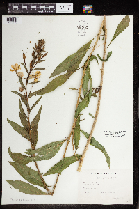 964303[1375210] United States, Wisconsin |
MIN:Plants | 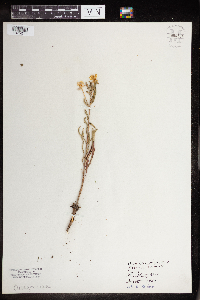 964304[1375211] United States, Michigan |
MIN:Plants | 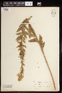 964305[1375212] United States, Iowa |
MIN:Plants | 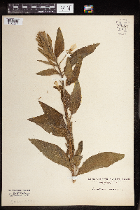 964306[1375213] United States, Indiana |
MIN:Plants |  964307[1375214] United States, Iowa |
MIN:Plants |  964308[1375215] United States, Iowa |
MIN:Plants |  964309[1375216] United States, Maine |
MIN:Plants |  965925[1356683] 1944-07-28 United States, District of Columbia, Harewood Road, south of Retreat Home. |
MIN:Plants |  965924[1356684] 1944-07-24 United States, District of Columbia, West of Salve Regina Building, Catholic University. |
MIN:Plants |  967544[1368110]Drew, L.A. s.n.1969-07-22 United States, Minnesota, Clearwater, Itasca State Park; T144N R36W sec. 36 SW SE 1/4, 47.241815 -95.182008 |
MIN:Plants | []Timothy J. S. Whitfeld 33792022-07-18 United States, Minnesota, Washington, Crystal Spring Scientific and Natural Area, 0.4 miles northeast of the intersection of Scandia Trail North and Hwy 95, 45.262882 -92.768219, 279m |
MIN:Plants |  972811[1398364]Janssens, J. 75/1791975-07-21 Belgium, Kiel, 10m |
MIN:Plants |  978928[1401837]Don Henson 2671971-09-02 United States, Michigan, Schoolcraft, NW 1/4 NE 1/4 Sec 14 and SW 1/4 SE 1/4 Sec 11 T42N-R16W., 46.03398 -86.27211 |
MIN:Plants | Clarkia breweri (A. Gray) Greene 477538[]Univ. of Calif. Bot. Gard. list 17 - 471974-00-00 United States, California, Stanislaus, Stanislaus Co. |
MIN:Plants | Clarkia breweri (A. Gray) Greene 516575[]Eastwood, Alice s.n.1898-05-03 United States, California, Priest Valley |
MIN:Plants | 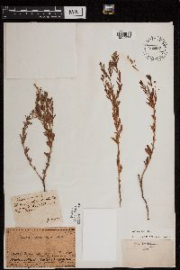 Gaura coccinea Nuttall ex Pursh 512987[1299673]Geyer, Charles 1951839-05-16 United States, Iowa, Near Council Bluffs [Iowa] - Upper Big Sioux River - Indian red pipe stone quarry [Minnesota] ... between the Missouri & Mississippi rivers.., 41.261944 -95.860833 |
MIN:Plants | Gaura coccinea Nuttall ex Pursh 160703[]Ballard, C. 31171907-08-13 United States, Minnesota, Clay, Muskoda [historic RR station near Hawley] - Red R. Val.;;139N;45W;17, 46.8545484 -96.3967683 |
MIN:Plants | Gaura coccinea Nuttall ex Pursh 160751[]Moyer, Lycurgus 26041894-06-00 United States, Minnesota, Chippewa, Chippewa Co.;;N;;, 45.048284 -95.613525 |
MIN:Plants | Gaura coccinea Nuttall ex Pursh 160752[]G. & L. 42-51885-06-16 United States, Minnesota, Spring Creek;;;;, 45.378295 -95.354472 |
MIN:Plants | Gaura coccinea Nuttall ex Pursh 160753[]Moyer, Lycurgus s.n.1894-06-00 United States, Minnesota, Chippewa, Montevideo;;117N;40W;, 44.9346263 -95.6757744 |
MIN:Plants | Gaura coccinea Nuttall ex Pursh 160754[]Sheldon, Edmund S13821891-08-00 United States, Minnesota, Lincoln, Lake Benton;;109N;45W;, 44.24108 -96.26172 |
MIN:Plants | Gaura coccinea Nuttall ex Pursh 160755[]Wirkrrshrim, W. s.n.1891-00-00 United States, Minnesota, Lincoln, Idlewild [pioneer village in sec. 18 of Ash Lake Township]. Lincoln Co.;;111N;45W;18, 44.42271 -96.31291 |
MIN:Plants | Gaura coccinea Nuttall ex Pursh 160756[]Barrett, J. s.n.1895-09-00 United States, Minnesota, Traverse, Browns Valley;;N;;, 45.595239 -96.833407 |
MIN:Plants | Gaura coccinea Nuttall ex Pursh 160757[]Sheldon, Edmund S64151893-09-00 United States, Minnesota, Traverse, Lake Traverse;;;;, 45.692648 -96.745148 |
MIN:Plants | Gaura coccinea Nuttall ex Pursh 160758[]Menzel, Max 34261896-07-00 United States, Minnesota, Pipestone, Pipestone [assuming the quarry area; town generally noted as Pipestone City by collector];Pipestone National Monument;106N;46W;01, 44.01585 -96.31767 |
MIN:Plants | Gaura coccinea Nuttall ex Pursh 160759[]Payne, F. s.n.1889-00-00 United States, Minnesota, Swift, Appleton;;120N;43W;, 45.1959377 -96.0418197 |
MIN:Plants | Gaura coccinea Nuttall ex Pursh 160760[]Payne, F. s.n.1890-05-00 United States, Minnesota, Swift, Appleton;;120N;43W;, 45.1959377 -96.0418197 |
MIN:Plants | Gaura coccinea Nuttall ex Pursh 160761[]Sheldon, Edmund S73231892-09-00 United States, Minnesota, Traverse, Wheaton, Traverse Co.;;127N;46W;, 45.8026162 -96.4484714 |
MIN:Plants | Gaura coccinea Nuttall ex Pursh 277922[]Roberts, Thomas s.n.1879-06-10 United States, Minnesota, Grant, Herman;;;;, 45.808572 -96.143392 |
MIN:Plants | Gaura coccinea Nuttall ex Pursh 282503[]Swanson, Gustav s.n.1933-06-20 United States, Minnesota, Pennington, Western Pennington Co, at Pembina Trai;, directly W of St. Hilaire;;N;;, 48.011741 -96.309953 |
MIN:Plants | Gaura coccinea Nuttall ex Pursh 352836[]Nielsen, E. 22951933-08-16 United States, Minnesota, Lincoln, near inlet to Dead Coon Lake;;N;;, 44.362206 -96.096396 |
MIN:Plants | Gaura coccinea Nuttall ex Pursh 364419[]Moyer, Lycurgus s.n.1898-06-13 United States, Minnesota, Big Stone, Ortonville;;N;;, 45.304687 -96.444779 |
MIN:Plants | Gaura coccinea Nuttall ex Pursh 364649[]Moyer, Lycurgus s.n.1898-06-04 United States, Minnesota, Big Stone, Ortonville;;121N;46W;, 45.2842633 -96.4124517 |
MIN:Plants | Gaura coccinea Nuttall ex Pursh 371169[]Moore, John 131591940-06-21 United States, Minnesota, Lac Qui Parle, Lac Qui Parle Co.; 4 1/2 mi north of Marietta;;119N;46W;, 45.1098216 -96.4028477 |
MIN:Plants | Gaura coccinea Nuttall ex Pursh 371204[]Moore, John 131901940-06-21 United States, Minnesota, Swift, Minnesota River bottoms, 3 mi S of Appleton on hwy 119, Swift Co.;Lac Qui Parle Wildlife Management Area;120N;43W;, 45.1959377 -96.0418197 |
MIN:Plants | Gaura coccinea Nuttall ex Pursh 371215[]Moore, John 131791940-06-21 United States, Minnesota, Big Stone, along the dirt road just W of hwy 75, 2 1/2 mi S of Ortonville;;N;;, 45.276519 -96.42478 |
MIN:Plants |  Gaura coccinea Nuttall ex Pursh 381238[]Moore, John 155151942-06-27 United States, Minnesota, Clay, Campbell Beach, 6 1/2 mi W of Hawley;;N;;, 46.879772 -96.473623 |
Google Map
Google Maps is a web mapping service provided by Google that features a map that users can pan (by dragging the mouse) and zoom (by using the mouse wheel). Collection points are displayed as colored markers that when clicked on, displays the full information for that collection. When multiple species are queried (separated by semi-colons), different colored markers denote each individual species.