University of Minnesota
http://www.umn.edu/
612-625-5000
http://www.umn.edu/
612-625-5000
Minnesota Biodiversity Atlas
Bell Museum
Dataset: MIN-Plants
Search Criteria: Brazil; excluding cultivated/captive occurrences
Bell Museum plants | |
 MIN:Plants | Ficus adhatodifolia Scholt 933812[]Plowman, T.; Sucre, D. 29211969-06-14 Brazil, Sudeste, Rio de Janeiro, Restinga da Tijuca |
MIN:Plants |  Eupatorium jaraguense Robinson 283643[1001139]Holway, E.W.D. 15741922-02-19 Brazil, Sao Paulo, Jaragua, near Taipas, summit of the peak |
MIN:Plants |  Mikania camporum Robinson 283639[1001776]Holway, E.W.D. 17661922-04-24 Brazil, Sao Paulo, Campos do Jordao, 1800m |
MIN:Plants |  Mikania stenomeres Robinson 283633[1001777]Holway, E.W.D. 18561922-05-17 Brazil, Rio de Janeiro, Serra Itatiaya, 2100m |
MIN:Plants |  Mikania virgata Robinson 283648[1001778]Holway, E.W.D. 13951921-12-13 Brazil, Minas Gerais, Minas Geraes; Barbacena |
MIN:Plants | 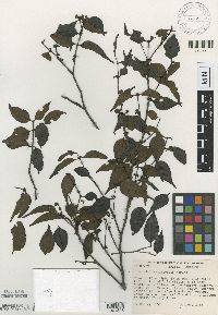 Mouriri angulicosta Morley 514314[1001828]Morley, T. 11561966-11-21 Brazil, Amazonas, Reserva Florestal Ducke NE of Manaus |
MIN:Plants | 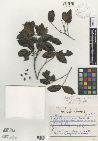 Mouriri arenicola Morley 516105[1001829]Araujo, D. 83351987-12-10 Brazil, Rio de Janeiro, Mun. Cabo Frio |
MIN:Plants | 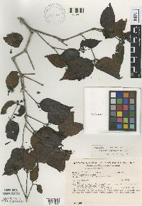 Mouriri torquata Morley 519108[1001832]Rodrigues, W. 85891969-00-00 Brazil, Amazonas, Manaus, estr. Manaus-Itacoatiara, km 64 |
MIN:Plants | 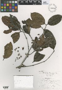 Mouriri dimorphandra Morley 899034[1001856]Prance, G.T. 90501968-12-17 Brazil, Amazonas, vicinity of Manaus
Reserva Florestal Walter Egler, road Manaus-Itacoatiara, km. 64 |
MIN:Plants | 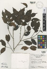 Mouriri duckeanoides Morley 516107[1001857]Prance, G.T. 30421966-11-10 Brazil, Amazonas, Manaus and vicinity
Road Manaus-Caracarai, km. 28 |
MIN:Plants | 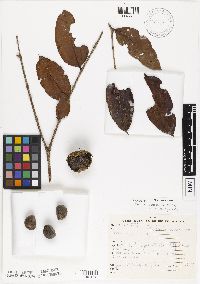 Mouriri megasperma Morley 514315[1001858]Vieira, J. 721950-09-00 Brazil, Espirito Santo, Norte do Rio Doce - Mata S. Gabriel |
MIN:Plants | 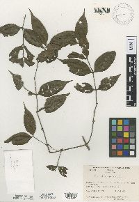 Mouriri monopora Morley 516110[1001861]Froes, R.L. 238821949-01-11 Brazil, Amazonas, Igarapé Jandiatuba |
MIN:Plants | 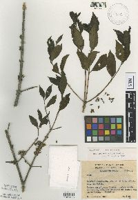 Mouriri obtusiloba Morley 441046[1001863]Oliveira, E. 18281961-08-24 Brazil, Goias, Goiás; Igarapé Uciricaca, regiao de Araguatins |
MIN:Plants | 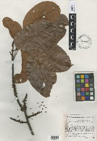 Pouteria ucuqui Pires & Schultes 450789[1002140]Schultes, R.E. 95531942-01-03 Brazil, Amazonas, Upper Rio Negro, Igrapé Uabá, opposite mouth of Rio Xié |
MIN:Plants |  Salvinia sprucei Kuhn 653382[1002339]Spruce, R. 16361851-06-00 Brazil, ad oram merid. flum. Amazonum ad oct. fl. Solimoes |
MIN:Plants |  Votomita orbinaxia Morley 516109[1002785]Silva, N.T. 6021960-07-00 Brazil, Para, Pará; Km. 100 da Rodovia Belém-Brasília |
MIN:Plants |  Marlierea ensiformis McVaugh 929527[1002847]Maguire, B. 604181965-11-24 Brazil, Serra da Neblina; Rio Negro, Rio Cauaburi, 750m |
MIN:Plants | 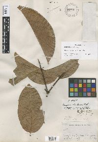 Eugenia chartacea McVaugh 929546[1002870]Krukoff, B.A. 49511933-06-21 Brazil, Amazonas, Rio Embira |
MIN:Plants | 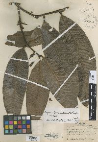 Eugenia tumulescens McVaugh 929541[1002875]de Lemos Froes, R. 211061945-10-06 Brazil, Amazonas, Porto Curucuhy, Rio Negro |
MIN:Plants | 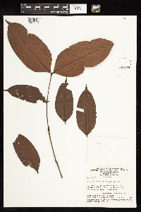 Mouriri retentipetala Morley 926159[1127681]Lleras, E. P169801973-08-01 Brazil, Amazonas, Rio Javari, behind Palmeiras Army Post |
MIN:Plants | 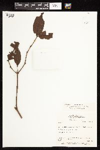 Votomita roraimensis Morley 122994[1127717]Hoplins, M.J.G. 5021986-06-02 Brazil, Roraima, BR 174, Manaus-Caracarai, km 523 |
MIN:Plants | 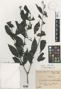 Mouriri bahiensis Morley 516106[1001830;1001831]Almeida, J. 1601968-10-16 Brazil, Bahia, Bahi; Itabuna
Ba. 8 km S de Itacaré |
MIN:Plants | Sorocea guilleminiana Gaudich. 431618[]Weiblen, G.D. GW15042001-11-02 Brazil, Kilometer 41, -1.5 -46.166667, 4m |
MIN:Plants | Brosimum lactescens (S. Moore) C.C. Berg 431423[]Weiblen, G.D. GW15132001-11-02 Brazil, Kilometer 41, -1.5 -46.166667, 4m |
MIN:Plants | Pseudolmedia laevis (Ruiz & Pav.) Macbride 431428[]Weiblen, G.D. GW15022001-11-02 Brazil, Kilometer 41, -1.5 -46.166667, 4m |
MIN:Plants | Pseudolmedia laevis (Ruiz & Pav.) Macbride 431429[]Weiblen, G.D. GW15072001-11-02 Brazil, Kilometer 41, -1.5 -46.166667, 4m |
MIN:Plants | Coussapoa latifolia Aubl. 487969[]Weiblen, G.D. GW15032001-11-02 Brazil, Kilometer 41, -1.5 -46.166667, 4m |
MIN:Plants | Brosimum melanopotamicum C.C. Berg 431623[]Weiblen, G.D. GW15052001-11-02 Brazil, Kilometer 41, -1.5 -46.166667, 4m |
MIN:Plants | Ficus paraensis Miq. (Miq.) 493709[]Weiblen, G.D. GW15002001-11-02 Brazil, Manaus, Kilometer 41, -1.5 -46.166667, 4m |
MIN:Plants | 431406[]Weiblen, G.D. GW15152001-11-02 Brazil, Kilometer 41, -1.5 -46.166667, 4m |
MIN:Plants |  Brosimum rubescens Taub. 431611[]Weiblen, G.D. GW15162001-11-02 Brazil, Kilometer 41, -1.5 -46.166667, 4m |
MIN:Plants |  Helianthostylis sprucei Baill. 431625[]Weiblen, G.D. GW15232001-11-07 Brazil, Kilometer 41, -1.5 -46.166667, 4m |
MIN:Plants | Sorocea steinbachii C. C. Berg 431434[]Weiblen, G.D. GW15012001-11-02 Brazil, Kilometer 41, -1.5 -46.166667, 4m |
MIN:Plants | Naucleopsis ternstroemiiflora (Hildbr.) C.C.Berg 431462[]Weiblen, G.D. GW15182001-11-02 Brazil, Kilometer 41, -1.5 -46.166667, 4m |
MIN:Plants | Pourouma tomentosa Miq. 487978[]Weiblen, G.D. GW15212001-11-02 Brazil, Kilometer 41, -1.5 -46.166667, 4m |
MIN:Plants | Pourouma villosa TrÈcul 487977[]Weiblen, G.D. GW15112001-11-02 Brazil, Kilometer 41, -1.5 -46.166667, 4m |
MIN:Plants | Mouriri NULL 488155[]Weiblen, G.D. GW15082001-11-02 Brazil, Kilometer 41, -1.5 -46.166667, 4m |
MIN:Plants | 487973[]Weiblen, G.D. GW15122001-11-02 Brazil, Kilometer 41, -1.5 -46.166667, 4m |
MIN:Plants | 487972[]Weiblen, G.D. GW15142001-11-02 Brazil, Kilometer 41, -1.5 -46.166667, 4m |
MIN:Plants |  Enterolobium contortisiliquum (Vell.) Morong 947596[1293530]Weiblen, G.D. GW15062001-11-02 Brazil, Kilometer 41, Manaus, -1.5 -46.166667 |
MIN:Plants |  Sorocea bondplandii (Baill.) Burger, Lanj. & Boer 453597[]Weiblen, G.D. GW11862000-08-23 Brazil, Hotel Bourbon, Iguassu Falls, -4.616667 -39.366667, 297m |
MIN:Plants |  Sorocea bondplandii (Baill.) Burger, Lanj. & Boer 453596[]Weiblen, G.D. GW11872000-08-23 Brazil, Hotel Bourbon, Iguassu Falls, -4.616667 -39.366667, 297m |
MIN:Plants | 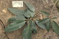 Coussapoa schottii Miq. 431573[]Weiblen, G.D. GW11882000-08-27 Brazil, Rio Grande do Sul, -32.016667 -52.066667, 3m |
MIN:Plants | 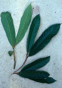 Trymatococcus amazonicus Poepp. & Endl. 431436[]Weiblen, G.D. GW15222001-11-07 Brazil, Kilometer 41, -1.5 -46.166667, 4m |
MIN:Plants | Pourouma minor Benoist 487979[]Weiblen, G.D. GW15102001-11-02 Brazil, Kilometer 41, -1.5 -46.166667, 4m |
MIN:Plants | Naucleopsis ulei (Warburg) Ducke 431461[]Weiblen, G.D. GW15092001-11-02 Brazil, Kilometer 41, -1.5 -46.166667, 4m |
MIN:Plants | Naucleopsis caloneura (Huber) Ducke 431619[]Weiblen, G.D. GW15172001-11-02 Brazil, Kilometer 41, -1.5 -46.166667, 4m |
MIN:Plants | Ficus adhatodifolia Scholt 431527[]Weiblen, G.D. GW11902000-08-27 Brazil, Rio Grande do Sul, Cataratas de Chaviscao, Rhonzino, -27 -51 |
MIN:Plants | Ficus cestrifolia Schott ex Spreng. 431574[]Weiblen, G.D. GW11892000-08-27 Brazil, Rio Grande do Sul, Cataratas de Chaviscao, Rhonzino, -27 -51 |
MIN:Plants | 829163[1299651]Holway, E.W.D. Brazil, Detailed locality information protected. This is typically done to protect rare or threatened species localities. |
MIN:Plants | erythroxylon coca Lam. 265083[1299708] Brazil, Para, Detailed locality information protected. This is typically done to protect rare or threatened species localities. |
MIN:Plants | 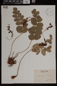 429629[1303004]Clayton, Temple s.n.1951-08-17 Brazil, Near Estrada da Mesa do Imperador |
MIN:Plants | 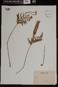 479149[1303005]Clayton, Temple s.n.1951-09-00 Brazil, Espirito Santo, Larte pedra near Collatina |
MIN:Plants |  479780[1299728]Clayton, Temple s.n.1951-09-26 Brazil, Sao Paulo, near Repressa da Santa Amara, vicinity of Santos, Sao Paulo state, -24.00886 -46.412475 |
MIN:Plants |  461351[1299729]Clayton, Temple s.n.1951-09-26 Brazil, Sao Paulo, near Repressa da Santa Amara, vicinity of Santos, Sao Paulo state, -24.00886 -46.412475 |
MIN:Plants |  461269[1299730]Clayton, Temple s.n.1951-09-25 Brazil, Sao Paulo, near Praia Grande, near Santos, Sao Paulo state., -24.00886 -46.412475 |
MIN:Plants |  Adiantum cuneatum Langsd. & Fisch. 281226[1303440]Durand, E.J. s.n. Brazil |
MIN:Plants |  Adiantum cuneatum Langsd. & Fisch. 50678[1303441]Murray, Alex s.n. Brazil |
MIN:Plants |  Adiantum cuneatum Langsd. & Fisch. 50682[1303442]Werner, Wm. C. s.n.1888-09-04 Brazil |
MIN:Plants |  Adiantum curvatum Kaulf. 50683[1303443]Murray, Alex s.n. Brazil |
MIN:Plants |  281227[1303450]Durand, E.J. s.n. Brazil |
MIN:Plants |  50668[1303452]Murray, Alex s.n. Brazil |
MIN:Plants |  Anemia gardneri Hook. 281206[1303589]Durand, E.J. s.n. Brazil, Rio de Janeiro, Rio, Brazil, -22.875113 -43.277548 |
MIN:Plants |  Anemia mandiocana Raddi 281208[1303590]Durand, E.J. s.n. Brazil, Rio de Janeiro |
MIN:Plants |  Anemia phyllitidis (L.) Sw. 281205[1303593]Durand, E.J. s.n. Brazil, Rio de Janeiro |
MIN:Plants |  Anemia phyllitidis (L.) Sw. 278969[1303594]unknown 1401910-04-00 Brazil, Serra Estrella bei Rio de Janeiro, Costa Gama, -22.875113 -43.277548 |
MIN:Plants |  Anemia tomentosa (Sav.) Sw. 281203[1303595]Durand, E.J. s.n. Brazil |
MIN:Plants |  Anemia radicans Raddi 281207[1303596]Durand, E.J. s.n. Brazil, Rio |
MIN:Plants |  Anemia tomentosa (Sav.) Sw. 281204[1303597]Durand, E.J. s.n. Brazil, Rio, Brazil, -22.875113 -43.277548 |
MIN:Plants |  Antrophyum brasilianum C.Chr. 281228[1303633]Durand, E.J. s.n. Brazil, Para |
MIN:Plants |  Aspidium martinicense Spreng. 52263[1303693]Riedel s.n.1885-12-00 Brazil |
MIN:Plants |  51107[1307335]Riarl 1241885-12-00 Brazil |
MIN:Plants |  50849[1307354]Widgren, J.F. s.n.1869-00-00 Brazil, [Illegible], -11.801959 -50.41211 |
MIN:Plants |  Blechnum brasiliense Desv. 51415[1309619]Riarl s.n. Brazil, Rio Janeiro |
MIN:Plants |  Blechnum capense Burm. f. 281201[1309621]Durand, E.J. s.n. Brazil, Rio |
MIN:Plants |  281224[1309623]Durand, E.J. s.n. Brazil, Rio |
MIN:Plants |  281225[1309625]Durand, E.J. s.n. Brazil, Rio |
MIN:Plants |  Blechnum tabulare (Thunb.) Kuhn 281202[1309627]Durand, E.J. s.n. Brazil, Rio |
MIN:Plants | Laelia flava Lindl. 450510[1313516]Williams, L.O. Brazil, Minas Gerais, Detailed locality information protected. This is typically done to protect rare or threatened species localities. |
MIN:Plants |  281229[1321024]Durand, E.J. s.n. Brazil, Rio, -22.875113 -43.277548 |
MIN:Plants |  281242[1321404]Durand, E.J. Brazil |
MIN:Plants |  281209[1321406]Durand, E.J. Brazil, Rio |
MIN:Plants |  278966[1321424]unknown s.n.1910-11-00 Brazil, Rio de Janeiro |
MIN:Plants |  281185[1321425]James, O.C. 1875-00-00 Brazil, near Rio |
MIN:Plants |  281191[1321427] 1870-07-28 Brazil, Rio |
MIN:Plants |  Cyathea schan-chin Mart. 281241[1321449]Durand, E.J. Brazil, Rio |
MIN:Plants |  Dennstaedtia arborescens Ekman ex Maxon 54390[1322630] Brazil |
MIN:Plants |  Dicranopteris bifida Maxon 278968[1322757]Luetzelburg 188761910-12-00 Brazil, Rio de Jeneiro: Petropolis |
MIN:Plants |  Diplazium marginatum Blume 281221[1327388]Durand, E.J. Brazil, Rio |
MIN:Plants |  Diplazium arboreum (Willd.) C.Presl 52489[1327389]Riarl 1885-12-00 Brazil |
MIN:Plants | 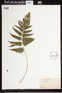 Diplazium arboreum (Willd.) C.Presl 281220[1327390]Durand, E.J. Brazil |
MIN:Plants | Doryopteris J.Sm. 281218[1327452] Brazil |
MIN:Plants | Doryopteris J.Sm. 281219[1327454] Brazil |
MIN:Plants | Doryopteris J.Sm. 281217[1327455] Brazil |
MIN:Plants | 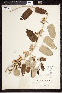 Araujia sericifera Brot. 224699[1325305]Holway, E.W.D. 16201922-00-00 Brazil, Pinheiros, -23.645117 -46.727484, 800m |
MIN:Plants | 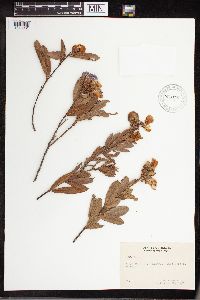 960436[1318931] 1951-09-22 Brazil, Ridge north of Caxambu, Minas Geraes |
MIN:Plants | 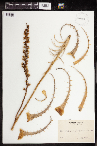 960435[1318932] 1951-09-22 Brazil, dry ridge north of Caxambu, Minas Geraes |
MIN:Plants |  960433[1318934] 1951-09-20 Brazil, Serra da Bocaina, State of Rio de Janeiro, -22.128467 -42.492712 |
MIN:Plants |  960431[1318936] 1951-09-22 Brazil, Ridge north of Caxambu, Minas Geraes |
MIN:Plants |  Dryopteris chrysodioides var. goyazensis Maxon & C.V.Morton 52866[1326419] 1952-04-00 Brazil |
Google Map
Google Maps is a web mapping service provided by Google that features a map that users can pan (by dragging the mouse) and zoom (by using the mouse wheel). Collection points are displayed as colored markers that when clicked on, displays the full information for that collection. When multiple species are queried (separated by semi-colons), different colored markers denote each individual species.