University of Minnesota
http://www.umn.edu/
612-625-5000
http://www.umn.edu/
612-625-5000
Minnesota Biodiversity Atlas
Bell Museum
Dataset: MIN-Plants
Search Criteria: Colombia; excluding cultivated/captive occurrences
Bell Museum plants | |
 MIN:Plants | 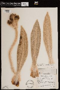 Espeletia incana Cuatrecasas 500142[1299493]Langenheim, J. 35111953-08-20 Colombia, Boyaca, In Paramo de la Rusia between La Osera and Quebrada de la Esperanza (station 78) on road between Duitama and Charala., 3624m |
MIN:Plants | Espeletia murilloi Cuatrecasas 500140[]Langenheim, J. 34201953-08-11 Colombia, Boyaca, In Paramo de la Rusia about 18 km. from Duitama on road to Charala., 3570m |
MIN:Plants | 488192[]Stein, Bruce 35871986-02-26 Colombia, Antioquia, Cordillera Central. Pass c. 8 km SE of Sonson on road toward Narino;;;;, -5.7166667 -75.25, 2700 - 2900m |
MIN:Plants | Espeletia discoidea Cuatrecasas 500143[]Langenheim, J. 36291953-08-30 Colombia, Boyaca, Paramo de Guantiva near km. marker 221 on road between Belen and Susacon., 3200m |
MIN:Plants | Espeletia grandiflora Humboldt & Bonpland 500161[]Langenheim, J.; et al. 36781953-09-16 Colombia, Cundinamarca, La Calera, Paramo de La Siberia ... Departmento de Cundinamarca, 3000m |
MIN:Plants | Maquira calophylla (Poepp. & Endl.) C.C. Berg 933815[]Schultes, R.; Cabrera, I. 168251952-06-20 Colombia, Vaupes: Rio Apaporis, Jinogoje (near mouth of Rio Piraparana). |
MIN:Plants |  Randia warneri Dwyer 677850[1002202]Warner, R.H. 2551974-05-08 Colombia, Choco, Chocó; Upper Río Jurubidá; one day's walk upstrea from last indigenous household; on path to hot springs, 200 - 300m |
MIN:Plants |  Unonopsis longipes Maas & Westra 677882[1002715]Warner 3011974-05-27 Colombia, Choco, Chocó; Cabo Currientes; Rio Parguera; at foot of Janano mountain, 50 - 100m |
MIN:Plants |  Pereskia colombiana Britton & Rose 929499[1002825]Smith, H.H. 18861898-04-00 Colombia, Magdelena, Santa Marta, 11.266877 -74.192546, 46m |
MIN:Plants |  Arrabidaea pachycalyx Sprague 929498[1002826]Smith, H.H. 7441898-00-00 Colombia, Magdelena, Santa Marta, 91m |
MIN:Plants |  Piper subcrenulatum C. DC. 929529[1002845]Smith. H.H. 12331898-00-00 Colombia, Magdelena, Santa Marta, 11.266877 -74.192546 |
MIN:Plants |  Mouriri micranthera Morley 516108[1001859;1001860]I. Cabrera, R. 4631961-04-04 Colombia, Dept. Valle: Bajo Calina |
MIN:Plants |  677774[1299731]Warner, R.H. 2941974-05-27 Colombia, Choco, Cabo Currientes; Rio Parguera at foot of Janano mountain, 50 100 |
MIN:Plants | Brassavola nodosa Hook. 677841[1304068]Warner, R.H. Colombia, Detailed locality information protected. This is typically done to protect rare or threatened species localities. |
MIN:Plants |  Adiantum terminatum Kze.; Miq. 830886[1303454]Rudas, A. 26781991-07-01 Colombia, -3.183333 -70.333333, 100m |
MIN:Plants |  Blechnum columbiense Hieron. 485154[1309620]Franco, P. 23771985-11-04 Colombia, Departamento de Antioquia; Municipio de Salgar, Cerio de Santa Ana, 3500m |
MIN:Plants |  Blechnum glandulosum Link 485155[1309622]Franco, P. 22271985-11-03 Colombia, Departamento de Antioquia: Municipio de Salgar, camino de ascenso al Cerro Plateado, quebrada La Liboriana, 2200 - 2240m |
MIN:Plants | 677765[1310364]Warner, R.H. Colombia, Detailed locality information protected. This is typically done to protect rare or threatened species localities. |
MIN:Plants | Palmorchis lobulata (Mansf.) C.Schweinf. & Correll 680030[1316908]White, Jeffrey W. Colombia, Choco, Detailed locality information protected. This is typically done to protect rare or threatened species localities. |
MIN:Plants |  481050[1321022]Sciefer, Helen 5741945-03-22 Colombia, Suba Hill, sabana of Bogota, Dept. Cundinamarca, 4.621168 -74.091424 |
MIN:Plants |  Cnemidaria C. Presl 677815[1321071]Warner, R.H. 1561973-08-03 Colombia, Chocó, Virudó; primary forest behind town, 0 - 100m |
MIN:Plants |  Cyathea andina Domin 482210[1321405]Ramirez, J.G. 11301987-06-25 Colombia, Antioquia, Quebrada "La Cristalina". Sector SE, 550 - 770m |
MIN:Plants |  925231[1321411]Pipoly, J. 159961991-11-15 Colombia, Amazonas, Amacayacu National Park, 200 - 220m |
MIN:Plants |  504938[1321426]Betancur, J. 12921989-08-10 Colombia, 3.263333 -74.285 |
MIN:Plants | 453604[1320109]Croat, Thomas B. Colombia, Masdevallia, Detailed locality information protected. This is typically done to protect rare or threatened species localities. |
MIN:Plants | 426977[1320110]Croat, Thomas B. Colombia, Narino, Detailed locality information protected. This is typically done to protect rare or threatened species localities. |
MIN:Plants | Scaphyglottis longicaulis S.Watson 680044[1320418]White, Jeffrey W. Colombia, Detailed locality information protected. This is typically done to protect rare or threatened species localities. |
MIN:Plants |  Dicranopteris pectinata Underw. 453537[1322759]van Rooden, J. 3991979-11-15 Colombia, Departmento Valle del Cauca: Municipio Buenaventura, community of San Isidro, 3.983333 -76.95, 230m |
MIN:Plants |  Dicranopteris remota Maxon 677814[1322760]Warner, R.H. 361973-07-25 Colombia, Dept. of Chocó; Bahía Solano, 0 - 100m |
MIN:Plants |  Didymochlaena truncatula (Sw.) J.Sm. 924895[1322767]Pipoly 162611991-11-15 Colombia, Amazonas: Leticia Municipio; Parque Nacional Natural Amacayacu. Quebrada de Agua Pudre, ca. 1.5 km NE de desemboca dura sobre el rio Amacayacu; Muestreo Permanente Estratè del MO., -3.783333 -70.25, 200 - 220m |
MIN:Plants |  Didymochlaena truncatula (Sw.) J.Sm. 839893[1322769]Rudas, A. 29401991-08-16 Colombia, Amazonas; Municipio de leticia. Parque Nacional Natural Amacayacu. Centro Administrativo Mata-mata (Inderena); Trocha que va al sector de Amavayacu., -3.783333 -70.25, 120m |
MIN:Plants |  Didymochlaena truncatula (Sw.) J.Sm. 830894[1322770]Rudas, A. 29401991-08-16 Colombia, Amazonas; Municipio de Leticia. Parque Nacional Natural Amacayacu. Centro Administrativo Mata-mata (Inderena) Trocha que va al sector de Amacayacu., -3.783333 -70.25, 120m |
MIN:Plants | 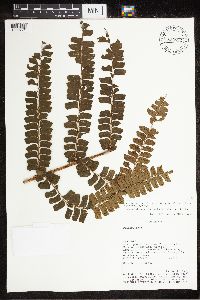 Didymochlaena truncatula (Sw.) J.Sm. 830892[1322771]Rudas, A. 29401991-08-16 Colombia, Amazonas; Municipio de leticia. Parque Nacional Natural Amacayacu. Centro Administrativo Mata-mata (Inderena); Trocha que va al sector de Amavayacu., -3.783333 -70.25, 120m |
MIN:Plants | Stelis Sw. 453607[1323062]Croat, Thomas B. Colombia, Narino, Detailed locality information protected. This is typically done to protect rare or threatened species localities. |
MIN:Plants | 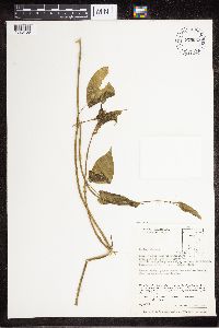 775552[1323158] Colombia |
MIN:Plants | 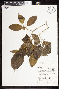 775561[1323159] Colombia |
MIN:Plants | 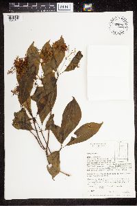 775554[1323160] Colombia |
MIN:Plants |  775536[1323161] Colombia |
MIN:Plants |  677753[1326416]Warner, R. 2501974-05-08 Colombia, Edge of Rio Jurubida by hot springs, 200 - 300m |
MIN:Plants |  Elaphoglossum apodum (Kaulf.) Schott 925539[1326897]Pipoly, J. 1991-11-15 Colombia, Amazonas, Leticia, Amacayacu National Park., 200 - 220m |
MIN:Plants |  Couma macrocarpa Barb.Rodr. 488852[1330998]Schultes, R.E. 57231944-01-00 Colombia, Vaupes. Rio Vaupes, near Miraflores., 6.9125 -71.816389 |
MIN:Plants |  Mandevilla trianae Woodson 850744[1332316]Betancur, Julio 6211988-09-15 Colombia, Antioquia, 12.4 Kms. from the entrance of San Luis towards Medellín, Cordillera Central, eastern slope, Medellín-Bogotá freeway., 6.090751 -75.180441, 500m |
MIN:Plants |  Mandevilla veraguensis Hemsl. 461449[1332317]Betancur, Julio 9101988-09-30 Colombia, 75.1345 -6.905833 |
MIN:Plants |  Mandevilla versicolor Woodson 173395[1332318]Rusby, H.H. 2931896-05-00 Colombia, Catalina, 8.861004 -75.405914 |
MIN:Plants |  Marsdenia rubrofusca E.Fourn. 830394[1332331]Rudas, A. 21771991-06-20 Colombia, -3.016667 -70.033333, 100m |
MIN:Plants |  Mesechites trifidus Müll.Arg. 461457[1332416]Betancur, Julio 7261988-09-27 Colombia, Antioquia, Yolombo; La Cancana Path, 35 Kms. of Amalfi to Medellín, Cordíllera Central, roadside., 6.598411 -75.011402 |
MIN:Plants |  Tabernaemontana siphilitica (L.f.) Leeuwenb. 506506[1332780]Rudas, A. 30451991-07-01 Colombia, Township of Tarapacá; Natural Amacayacu National Park; Cabaña Pamaté; Trail that leaves the cabin;, 4.95 -75.616667, 100m |
MIN:Plants |  Tabernaemontana vanheurckii Müll.Arg. 426980[1332782]B., Miryam Monsalve 1671984-08-09 Colombia, Valle Del Cauca, Bajo Calima; Concesión Pulpapel/Buenaventura., 3.880099 -77.031164, 100m |
MIN:Plants |  Anthurium warocqueanum Moore 677869[1335012]Warner, R. H. 3211974-06-02 Colombia, Choco, 50 - 100m |
MIN:Plants |  Anthurium warocqueanum Moore 677868[1335013]Warner, R. H. 3211974-06-02 Colombia, Choco |
MIN:Plants |  Huperzia molongensis (Herter) Holub 476177[1338969]Franco, P. 1985-11-04 Colombia, Antioquia, Salgar, Cerro Plateau, 2700 - 3300m |
MIN:Plants |  Huperzia brongniartii (Spring) Trevis. 461447[1338970]Silverstone-Sopkin, Felipe A. 46511988-08-21 Colombia, Choco, San Jose del Palmar, Cerro del Torre, 2700 - 2800m |
MIN:Plants |  Hymenophyllum andinum Bosch 481057[1338990]Uribe, Lorenzo 1939-00-00 Colombia, Mountains of Santandercito, Cundinamarca, 1900m |
MIN:Plants |  Lindsaea lancea (L.) Bedd 504845[1339581]Velasquez, Patricia 2191989-06-29 Colombia, Antioquia, San Carlos, El Jordan. Alto de Samana, 880m |
MIN:Plants |  Lygodium radiatum Prantl 677819[1342006]Warner, R.H. 1731973-08-17 Colombia, Choco, W ridge of Alto de Buey, 6.094341 -77.278378, 500m |
MIN:Plants |  Metaxya rostrata (Humb. & Bonpl. ex Willd.) C. Presl 925228[1342356]Pipoly, J. 16054A1991-11-15 Colombia, Amazonas: Leticia Municipio; Parque Nacional Natural Amacayacu. Quebrada de Agua Pudre, ca. 1.5 km NE de desemboca dura sobre el rio Amacayacu; Muestreo Permanente Estratè del MO.; -3.783333 -70.25, -3.783333 -70.25, 200 - 220m |
MIN:Plants |  Metaxya rostrata (Humb. & Bonpl. ex Willd.) C. Presl 925227[1342357]Pipoly, J. 16054A1991-11-15 Colombia, Amazonas: Leticia Municipio; Parque Nacional Natural Amacayacu. Quebrada de Agua Pudre, ca. 1.5 km NE de desemboca dura sobre el rio Amacayacu; Muestreo Permanente Estratè del MO.; -3.783333 -70.25, -3.783333 -70.25, 200 - 220m |
MIN:Plants |  Peperomia blephariphylla Trel. & Yunck. 677891[1350179]Warner, R.H. 132 Colombia, Chocó, Virudó., 5.403023 -77.402199, 0 - 100m |
MIN:Plants |  Peperomia eburnea Sodiro 925242[1350180]Silverstone-Sopkin, Felipe A. 42941988-08-11 Colombia, Chocó, San José del Palmar; Cerro del Torrá, vertiente, oriental, arriba del helipuerto [[Cerro del Torrá, slope, eastern, above the heliport]], 4.648007 -73.859841 |
MIN:Plants |  Peperomia emarginella C.DC. 677885[1350181]Warner, R.H. 302 Colombia, Chocó, Cabo Currientes; Río Parguera; at foot of Janano mountain., 5.481471 -77.538681, 50 - 100m |
MIN:Plants |  Peperomia serpens C.DC. 830885[1350190]Pipoly, J. 150811991-04-08 Colombia, Parque Nacional Natural Amacayacu, Centro Administrativo Amacayacu-Inderena. Trail to the Matamata hut., -1.442912 -71.572395, 150m |
MIN:Plants |  Piper aequale Vahl 925537[1350366]Brant, Alan E. 12881987-10-12 Colombia, Antioquia, Road to Briceño; 1.1 km W of Medellin. Caucasia highway., 6.259396 -75.612911, 1800m |
MIN:Plants |  Piper aequale Vahl 925243[1350367]Brant, Alan E. 16691987-11-05 Colombia, Antioquia: Mpio. San Carlos; 47.5 km E of San Carlos; Lake Punchina (Quebradas La Villa y El Macho), 6.233333 -74.866667, 650m |
MIN:Plants |  Piper aleyreanum C.DC. 830895[1350368]Pipoly, J. 153741991-04-14 Colombia, Amazonas., 10.37255 -74.416915 |
MIN:Plants |  Piper artanthe C. DC. 925536[1350375]Brant, Alan, E. 14651987-10-22 Colombia, Antioquia: road to San Rafael ca 4 km east of Guatapé - Santa Rita road (Finca Montepinar)., 6.25 -75.133333, 1850m |
MIN:Plants |  Piper artanthe C. DC. 453534[1350381]Brant, Alan E. 11461987-10-07 Colombia, Antioquia, Along road to Cerro del Padre Amaya, 3.9 km from Meddellin-Santa Fe de Antioquia road., 6.556867 -75.828056 |
MIN:Plants |  Piper brisasense Yunck 899983[1350384]Zarucchi, James L. 6173 Colombia, Mpio. de Argelia; Km 17 of road Sonsón-Argelia (2 km past fork in road to Nariño)., 5.75 -75.2, 2160m |
MIN:Plants |  Piper dumosum Rudge 830882[1350393]Pipoly, J. 150461991-04-08 Colombia, Parque Nacional Natural Amacayacu, Centro Administrativo Amacayacu-Inderena. Trocha hacia la cabaña Matamatá. [[Amacayacu National Natural Park, Amacayacu-Inderena Administrative Center. Trail to the Matamatá hut., -3.783333 -70.25, 150m |
MIN:Plants |  Piper dumosum Rudge 830884[1350394]Pipoly, J. 151021991-04-08 Colombia, Parque Nacional Natural Amacayacu. Amacayacu-Inderena Administrative Center.; Leticia, -1.442912 -71.572395, 150m |
MIN:Plants |  Piper heterophyllum Ruiz & Pav. 830891[1350401]Rudas, A. 13721991-02-22 Colombia, Amazonas; Municipio de Leticia; Parque Nacional Natural Amacayacu; Centro Administrativo Mata-matá, -3.783333 -70.283333, 120m |
MIN:Plants |  Piper hispidum Sw. 427284[1350403]Brant, Alan E. 15021987-10-25 Colombia, Antioquia, 25.5 km E then S of San Rafael on San Rafael-San Carlos road., 6.458166 -75.327145 |
MIN:Plants |  Piper hispidum Sw. 478594[1350405]Rudas, A. 16821991-03-20 Colombia, Amazonas: Puerto Narino Municipio Parque Nacional Natural Amavayacu; Centro Administrativo Amacayacu (Inderena), -3.783333 -70.283333 |
MIN:Plants |  Piper hispidum var. trachydermum (Trel.) Yunck. 677904[1350409]Warner, R.H. 57 Colombia, Chocó, Bahía Solano., 6.226229 -77.40611, 0 - 100m |
MIN:Plants |  Piper holtonii C.DC. 925233[1350410]Silverstone-Sopkin, Felipe A. 33891987-12-19 Colombia, Depto.: Valle; Municipio El Cerito; Hacienda San Gerardo (cerca de frontera con Municipio Guacari, cerca de pueblo de Guabas, parte plana del Valle del Río Cauca), 4.046111 -75.984722, 950m |
MIN:Plants |  Piper lanceaefolium Kunth 677867[1350414]Warner, R.H. 25 Colombia, Chocó, Bahía Solano., 6.226229 -77.40611 |
MIN:Plants |  Piper marginatum Jacq. 504870[1350418]Brant, Alan E. 12721987-10-11 Colombia, Antioquia, Road to Nechi; 1.55 km from Caucasia-Planeta Raica Road., 7.983182 -75.198166, 50m |
MIN:Plants |  Piper marginatum Jacq. 677743[1350419]Warner, R.H. 33 Colombia, Chocó, Bahía Solano; quebrada la Chocolatada., 6.226229 -77.40611, 0 - 100m |
MIN:Plants |  Piper munchanum C.DC. 925239[1350423]Brant, Alan E. 14811987-10-24 Colombia, Antioquia, 4.8 km E of San Rafael., 6.200755 -75.548131, 1040m |
MIN:Plants |  Piper novo-granatense C.DC. 677854[1350424]Warner, R.H. 323 Colombia, Chocó, By the school., 5.403023 -77.402199 |
MIN:Plants |  Piper obliquum Ruiz & Pav. 830877[1350425]Pipoly, J. 152471991-04-12 Colombia, Amazonas, -3.783333 -70.25, 100m |
MIN:Plants |  Piper obliquum Ruiz & Pav. 488772[1350426]Brant, Alan E. 16741987-11-05 Colombia, Antioquia: Mpio. San Carlos; 47.5 km E of San Carlos; Lake Punchina (Quebradas La Villa y El Macho), 6.233333 -74.866667, 650m |
MIN:Plants |  Piper pothomorphe C.DC. 439075[1350429]Silverstone-Sopkin, P. A. 51501989-05-06 Colombia, Departamento Risaralda. Hacienda Alejandria, kilometer 6 carretera La Virginia-Cerrito, lomas bajas en extremo norteño de parte ancha Del Valle del Rio Cuaca [[Hacienda Alejandria, kilometer 6 La Virginia-Cerrito highway, low hills at the northern end of the wide part of the Cuaca River Valley]], 6.02348 -74.518574, 940m |
MIN:Plants |  Piper pothomorphe C.DC. 677853[1350430]Warner, R.H. 98 Colombia, Chocó, 50 - 100m |
MIN:Plants |  Piper soledadense Trel. 830881[1350435]Pipoly, J. 152201991-04-12 Colombia, Amazonas, -3.783333 -70.25, 100m |
MIN:Plants |  Piper soledadense Trel. 830887[1350436]Pipoly, John J. 153771991-04-14 Colombia, Amazonas, -3.783333 -70.25, 100m |
MIN:Plants |  Piper trigonum C.DC. 677745[1350437]Warner, R.H. 119 Colombia, Chocó, 300 meters downstream and across the river from Catrú., 5.333333 -77.066667, 50 - 100m |
MIN:Plants |  Piper tristemon C.DC. 904108[1350438]Zarucchi, James L. 53571987-09-16 Colombia, Antioquia. Along road to Cerro del Padre Amaya, 9.1 kilometers from Medellin-Santa Fé de Antioquia road., 6.266667 -75.683333, 2840m |
MIN:Plants |  Piper umbellatum Jacq. 830898[1350439]Rudas, A. 18241991-04-02 Colombia, Amazonas, Municipio de Leticia; Parque Nacional Natural Amacayacu; Centro Administrativo Mata-mata (Inderena); Trocha desde la cabana del abuelo pandura hasta la cabana del Cetro Administativo de Amacayacu [Municipality of Leticia; Amacayacu National Natural Park; Mata-mata Administrative Center (Inderena); Trail from the hut of the grandfather pandura to the hut of the Administrative Center of Amacayacu], 70.25 -3.783333, 150m |
MIN:Plants |  775501[1350709]Soejarto, D.D. 39191973-04-26 Colombia, Antioquia; Buenos Aires; Municipio de Anorí, entre Dos Bocas y Anorí., 7.073592 -75.146966, 400 - 700m |
MIN:Plants |  775544[1350710]Soejarto, D.D. 3978 Colombia, Anorí, Río Anorí valley, between Dos Bocas and Anorí. Transitional zone between humid forest and very humid tropical mountain., 7.281773 -75.079298, 400 - 700m |
MIN:Plants |  Camassia esculenta Lindl. 766743[1350741] s.n. Colombia, [illegible]. |
MIN:Plants |  Disocactus Lindl. 677805[1349072]Warner, R.H. 248 Colombia, Choco, Upper Río Jurubidá; one day's walk upstream from last indigenous household., 5.844327 -77.277424, 200 - 300m |
MIN:Plants |  775494[1349632]Soejarto, D.D. 39481973-04-26 Colombia, Antioquia, Municipio de Anori, Corregimiento de Providencia, Valle del Rio Anori, entre Dos Bocas y Anori. ; Buenos Aires; 4 km. from Providencia, 7.370778 -74.94463, 400 - 700m |
MIN:Plants |  Bejaria resinosa L.f. 485188[1349673]Silverstone-Sopkin, Philip A. 54221989-08-05 Colombia, Depto.: Boyaca; Mun. Paipa; Piscinas Municipales de Aguas Termales, 4.838889 -75.545833, 2500 - 2600m |
MIN:Plants |  Cavendishia erythrostegia Luteyn 925248[1349686]Silverstone-Sopkin, P.A. 44411988-08-15 Colombia, Choco, S. Jose d. Palmar, 4.648007 -73.859841, 2730m |
MIN:Plants |  Cavendishia leucantha Luteyn 461448[1349687]Silverstone-Sopkin, Philip A. 45151988-08-17 Colombia, Choco, Cerro del Torra,, 4.648007 -73.859841, 2500 - 2550m |
MIN:Plants |  Cavendishia palustris A.C.Sm. 677747[1349691]Warner, R.H. 2541974-05-08 Colombia, Choco, Upper Rio Jurubida; one day's walk upstream from last indigenous household, 5.829273 -77.27406, 200 - 300m |
MIN:Plants | 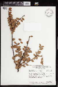 Disterigma alaternoides Nied. 485153[1349702]Silverstone-Sopkin, P.A. 48951988-04-29 Colombia, Mun: San Jose del Palmar, 4.648007 -73.859841 |
MIN:Plants | 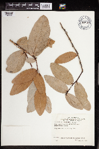 Macleania pentaptera Hoerold 680043[1349725]White, Jeffrey W. 371973-07-24 Colombia, Choco, south of Virudo, 5.403023 -77.402199 |
MIN:Plants | 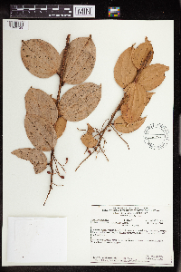 Orthaea paniculata Luteyn 461472[1349729]Silverstone-Sopkin, P.A. 45161988-08-17 Colombia, Choco, Mun: S. Jose del Palmar, 4.648007 -73.859841, 2500 - 2550m |
Google Map
Google Maps is a web mapping service provided by Google that features a map that users can pan (by dragging the mouse) and zoom (by using the mouse wheel). Collection points are displayed as colored markers that when clicked on, displays the full information for that collection. When multiple species are queried (separated by semi-colons), different colored markers denote each individual species.