University of Minnesota
http://www.umn.edu/
612-625-5000
http://www.umn.edu/
612-625-5000
Minnesota Biodiversity Atlas
Bell Museum
Dataset: MIN-Plants
Search Criteria: Nicaragua; Matagalpa; excluding cultivated/captive occurrences
1
Page 1, records 1-13 of 13
Bell Museum plants | |
 MIN:Plants | Solanum lanceolatum Cavanilles 488013[]Moreno, Pedro; et al. 204021983-02-22 Nicaragua, Matagalpa, Km 136, entre Matagalpa y Jinotega;;;;, 12.4166667 -85.9166667, 1000 - 1200m |
MIN:Plants | Elleanthus tonduzii Schltr. 925295[1310230]Rueda, R. Nicaragua, Matagalpa, Detailed locality information protected. This is typically done to protect rare or threatened species localities. |
MIN:Plants | 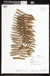 925250[1321414]Rueda, R.M. 141472000-07-15 Nicaragua, Matagalpa, Cerro Musún Nature Reserve, 500 - 1400m |
MIN:Plants | 925296[1320372]Rueda, R.M. Nicaragua, Matagalpa, Detailed locality information protected. This is typically done to protect rare or threatened species localities. |
MIN:Plants | 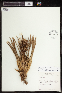 Guzmania monostachya Rusby 438050[1345078]Stevens, Warren Douglas 11,9061979-01-25 Nicaragua, Matagalpa, Ridge along road between La Danta and La Luna, E of Esquiplas., 11.764729 -85.889604, 960 - 1000m |
MIN:Plants | 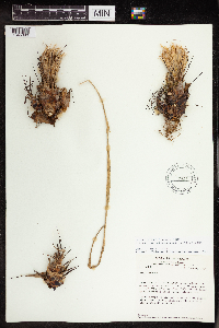 540919[1345093]Stevens, Warren Douglas 11,8661979-01-25 Nicaragua, Matagalpa, Ridge along road between La Danta and La Luna, E of Esquiplas., 11.764729 -85.889604, 960 - 1000m |
MIN:Plants | 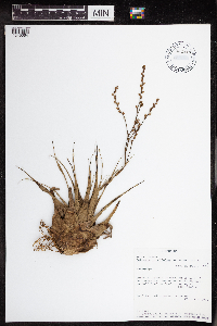 Catopsis juncifolia Mez & Wercklé 962417[1345064]Soza, D. 1161984-07-20 Nicaragua, Matagalpa, Cerro El Apante Grande, ca 2 km to the S of Matagalpa., 12.925592 -85.917474, 1000 - 1100m |
MIN:Plants | 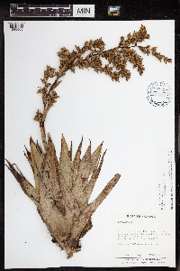 Catopsis montana L.B.Sm. 962416[1345065]Moreno, P.P. 34341980-10-07 Nicaragua, Matagalpa, Highway to Jinotega, Fuente Pura at 11 km de Matagalpa highway to Jinotega., 13.026298 -85.924505, 1400 - 1450m |
MIN:Plants | 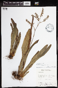 Catopsis nitida Griseb. 962412[1345072]Moreno, P.P. 34321980-10-07 Nicaragua, Matagalpa, 1400 - 1450m |
MIN:Plants | 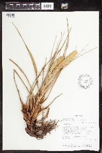 Tillandsia fasciculata Swartz 488412[1345160]Grijalva, A. 14111982-10-09 Nicaragua, Matagalpa, Chapel of Es-Equipulas, situated 20 km NE of El Tuma (between Río Wasaka and Río Bulbul); ca 13., 13.189679 -85.613782, 500m |
MIN:Plants | 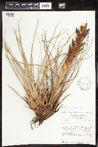 Tillandsia fasciculata Swartz 515308[1345163]Stevens, Warren Douglas 12,0431979-02-12 Nicaragua, Matagalpa, Lower W slope of Cerro Musun, Quebrada El Jobo, a tributary of Río Paiwas., 12.985186 -85.242346, 300m |
MIN:Plants |  Tillandsia festucoides Brongn. ex Mez 515294[1345164]Stevens, Warren Douglas 12,0421979-02-12 Nicaragua, Matagalpa, Lower W slope of Cerro Musun, Quebrada El Jobo, a tributary of Río Paiwas., 12.985186 -85.242346, 300m |
MIN:Plants |  Tillandsia schiedeana Steud. 540912[1345203]Stevens, Warren Douglas 185771980-11-30 Nicaragua, Matagalpa, Departamento de MATAGALPA: 0.7 km W of Hwy 3 on road to San Simon de Palcila, 12.983333 -85.916667, 1200m |
1
Page 1, records 1-13 of 13
Google Map
Google Maps is a web mapping service provided by Google that features a map that users can pan (by dragging the mouse) and zoom (by using the mouse wheel). Collection points are displayed as colored markers that when clicked on, displays the full information for that collection. When multiple species are queried (separated by semi-colons), different colored markers denote each individual species.