University of Minnesota
http://www.umn.edu/
612-625-5000
http://www.umn.edu/
612-625-5000
Minnesota Biodiversity Atlas
Bell Museum
Dataset: MIN-Plants
Taxa: Balsamorhiza
Search Criteria: excluding cultivated/captive occurrences
1
Page 1, records 1-19 of 19
Bell Museum plants | |
 MIN:Plants | Balsamorhiza macrophylla Nuttall 478552[]Bright, R. 72-781972-00-00 United States, Idaho, Franklin, [no further data] |
MIN:Plants | 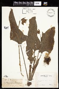 Balsamorhiza deltoidea Nuttall 231064[1040621]Congdon, J. s.n.1883-04-00 United States, California, Mariposa, Mt. Buckingham, Mariposa County;Yosemite Nationaltional Park;;;, 37.5233 -119.8588 |
MIN:Plants | 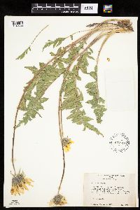 Balsamorhiza NULL 457549[1040630]Weber, W. 73951952-05-17 United States, Utah, Uintah, Uintah Co.: ... between Headquarters and Split Mt. Gorge, Dinosaur Nat. Mon, 7 mi. north of Jensen;Dinosaur National Monument |
MIN:Plants | 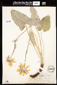 Balsamorhiza sagittata (Pursh) Nuttall 203220[1040625]Nelson, Aven; et al. 56131899-07-01 United States, Wyoming, Park, Yellowstone National Park ... Glen Creek;Yellowstone National Park |
MIN:Plants | 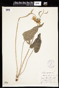 Balsamorhiza sagittata (Pursh) Nuttall 301700[1040627]Yuncker, T. 53501935-06-22 United States, Wyoming, Teton, ...near Lake Leigh, Teton Nat. Park..."Jackson Hole", vicinity of Jackson Lake and ont he lower slopes of the Teton Mts.;Grand Teton National Park;;;, 43.479929 -110.762428, 2591m |
MIN:Plants |  Balsamorhiza sagittata (Pursh) Nuttall 248863[1040626]Mearns, E. 7651902-05-18 United States, Wyoming, Park, Yellowstone National Park ... Mammoth Hot Springs;Yellowstone National Park |
MIN:Plants |  Balsamorhiza sagittata (Pursh) Nuttall 434696[1040628]Jones, Quentin 1921950-07-11 United States, Idaho, Idaho, Idaho Co.: Heaven's Gate, Seven Devil Mountains; Sec. 32, T24N, R1W.;;024N;01W;32 |
MIN:Plants |  Balsamorhiza hookeri Nuttall 680240[1040623]Bright, R. 75-281975-06-05 United States, Idaho, Minidoka, 20 mi east of Burley on I-35, at rest stop.;;;;, 42.535071 -113.399568, 1341m |
MIN:Plants |  Balsamorhiza sagittata (Pursh) Nuttall 762031[1040629]Kittelson, J. 2171976-06-16 United States, Utah, Kane, Bryce Canyon National Park. County: Kane. Locality: South White Man bench. 13 miles south of the entrance to Bryce Canyon Nat'l Park on main park road. 1/4 mile due west of road...Paunsaugunt Plateau., 2682m |
MIN:Plants |  Balsamorhiza deltoidea Nuttall 231062[1040620]Congdon, J. s.n.1887-05-08 United States, California, Mariposa, Footman Mt.;Yosemite National Park;;;, 37.54549 -119.82489 |
MIN:Plants |  Balsamorhiza sagittata (Pursh) Nuttall 203244[1040624]Burglehaus, F. s.n.1893-05-00 United States, Wyoming, Park, Near Mammoth Hot Springs;Yellowstone National Park, 1890m |
MIN:Plants |  Balsamorhiza deltoidea Nuttall 231066[1040622]Congdon, J. s.n.1897-04-25 United States, California, Mariposa, Mormon Bar Hill, Mariposa County;Yosemite National Park |
MIN:Plants | Balsamorhiza sagittata (Pursh) Nuttall 580352[]Monserud, W. 5251957-06-25 United States, Colorado, Montrose, Montrose County. On mesa above Black Canyon of the Gunnison river;Black Canyon of the Gunnison National Park |
MIN:Plants |  Balsamorhiza sagittata (Pursh) Nuttall 601185[1299494]Munns, C. 3581966-04-28 Canada, British Columbia, Trans-Canada Hwy. 1 between Lytton and Shaw Springs |
MIN:Plants |  Balsamorhiza sagittata (Pursh) Nuttall 524180[1158952]Cooper, William s.n.1906-07-17 United States, Wyoming, Park, Yellowstone Park ... Upper Basin;Yellowstone National Park, 2256m |
MIN:Plants | Balsamorhiza macrophylla Nuttall 478551[]Bright, R. 73-2241973-00-00 United States, Idaho, Franklin, [no further data] |
MIN:Plants |  Balsamorhiza deltoidea Nuttall 230928[1158950]Congdon, J. s.n.1888-04-08 United States, California, Mariposa, Devil's Gulch Trail, Mariposa County;Yosemite National Park |
MIN:Plants |  Balsamorhiza sagittata (Pursh) Nuttall 203243[1158951]Burglehaus, F. s.n.1893-05-00 United States, Wyoming, Park, Yellowstone National Park ... near Mammoth Hot Springs;Yellowstone National Park, 1890m |
MIN:Plants |  Balsamorhiza sagittata (Pursh) Nuttall 950990[1290579]Stork, H. E. s.n. United States, Wyoming, Park, Yellowstone National Park |
1
Page 1, records 1-19 of 19
Google Map
Google Maps is a web mapping service provided by Google that features a map that users can pan (by dragging the mouse) and zoom (by using the mouse wheel). Collection points are displayed as colored markers that when clicked on, displays the full information for that collection. When multiple species are queried (separated by semi-colons), different colored markers denote each individual species.