University of Minnesota
http://www.umn.edu/
612-625-5000
http://www.umn.edu/
612-625-5000
Minnesota Biodiversity Atlas
Bell Museum
Dataset: MIN-Plants
Taxa: Carum
Search Criteria: excluding cultivated/captive occurrences
1
Page 1, records 1-47 of 47
Bell Museum plants | |
 MIN:Plants |  Carum carvi L. 492584[1034189]Gerdes, Lynden 49872005-06-09 United States, Minnesota, Lake, Superior National Forest. T60N R06W S25NENWNW Lake County...Superior National Forest. ENE of Isabella, MN, approximatetly 0.86 miles east of Wilson Lake at intersection of FR 170 and FR 348.. 060N 06W 25, 47.652407 -91.032996 |
MIN:Plants |  Carum carvi L. 162985[1034209]Wirkrrshrim, W. s.n.1891-06-00 United States, Minnesota, Lincoln, Idlewild [pioneer village in sec. 18 of Ash Lake Township]. Lincoln Co.;;111N;45W;18, 44.42271 -96.31291 |
MIN:Plants |  Carum carvi L. 162986[1034204]Moyer, Lycurgus s.n.1885-06-00 United States, Minnesota, Chippewa, Montevideo;;117N;40W;, 44.934626 -95.675774 |
MIN:Plants |  Carum carvi L. 162987[1034201]Frost, W. F1241892-06-00 United States, Minnesota, Meeker, Litchfield;;N;;, 45.127185 -94.528047 |
MIN:Plants |  Carum carvi L. 162988[1034211]Sheldon, Edmund S26101892-06-00 United States, Minnesota, Mille Lacs, Mille Lacs Reservation;Mille Lacs Indian Reservation;N;;, 46.107225 -93.716142 |
MIN:Plants |  Carum carvi L. 162989[1034196]Manning, Sara s.n.1898-05-29 United States, Minnesota, Wabasha, Lake City;;N;;, 44.4081 -92.252454 |
MIN:Plants |  Carum carvi L. 162991[1034220]Bergman, H. s.n.1912-06-22 United States, Minnesota, Becker, Detroit;;N;;, 46.847559 -95.858616 |
MIN:Plants |  Carum carvi L. 162992[1034221]Ballard, C. 28431901-06-05 United States, Minnesota, Clay, Moorhead;;N;;, 46.873852 -96.767581 |
MIN:Plants |  Carum carvi L. 267177[1034217]Anonymous 821912-06-00 United States, Minnesota, Kandiyohi, Willmar;;N;;, 45.121908 -95.043342 |
MIN:Plants |  Carum carvi L. 289412[1034192]Butters, F.; Buell, Murray 3471932-07-08 United States, Minnesota, Cook, near drain from house, Susie Island, T63N, R7E;North Shore / Susie Islands, The Nature Conservancy;063N;07E;, 47.973776 -89.578978 |
MIN:Plants |  Carum carvi L. 300927[1034203]Chandonnet, Z. s.n.1910-06-06 United States, Minnesota, Otter Tail, Perham;;N;;, 46.594404 -95.572542 |
MIN:Plants |  Carum carvi L. 348228[1034200]Moyle, J. s.n.1938-06-10 United States, Minnesota, Carver, roadside near Waconia;;116N;25W;, 44.8476 -93.827753 |
MIN:Plants |  Carum carvi L. 353575[1034199]Lakela, Olga 24871938-06-26 United States, Minnesota, Saint Louis, S19, Duluth;;N;;, 46.783273 -92.106579 |
MIN:Plants |  Carum carvi L. 354044[1034222]Lakela, Olga 25801938-07-23 United States, Minnesota, Saint Louis, 7th Ave W at Skyline Parkway, Duluth;;N;;, 46.78498 -92.11441 |
MIN:Plants |  Carum carvi L. 354588[1034190]Moyle, J. 13141934-07-18 United States, Minnesota, Pennington, Thief River Falls;;N;;, 48.137191 -96.175395 |
MIN:Plants |  Carum carvi L. 359222[1034223]Alaspa, E.; Alaspa, H. s.n.1940-07-15 United States, Minnesota, Carlton, ca 1 1/2 mi S of Scanlon;;N;;, 46.684895 -92.428246 |
MIN:Plants |  Carum carvi L. 370292[1034218]Moore, John; et al. 145061941-06-15 United States, Minnesota, Pennington, beside hwy 59, 1 mi SE of Thief River Falls;;;;, 48.137191 -96.175395 |
MIN:Plants |  Carum carvi L. 381154[1034202]Rosendahl, C.; et al. 75911942-06-17 United States, Minnesota, Winona, Schultz's yard, 2 mi N of Utica;;;;, 44.004486 -91.954879 |
MIN:Plants |  Carum carvi L. 381364[1034226]Moore, John; et al. 154771942-06-20 United States, Minnesota, Dodge, West Concord;;108N;17W;, 44.153161 -92.862109 |
MIN:Plants |  Carum carvi L. 401388[1034208]Butters, F.; et al. 108821939-07-05 United States, Minnesota, Cook, Cook County...upper road, 1 mi E of Grand Portage;Grand Portage Indian Reservation / North Shore;063N;06E;, 47.958468 -89.703576 |
MIN:Plants | 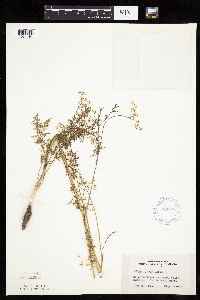 Carum carvi L. 420626[1034191]Lakela, Olga 105551950-06-29 United States, Minnesota, Saint Louis, Congdon River Terrace, below Superior St, Duluth;;N;;, 46.81662 -92.05412 |
MIN:Plants | 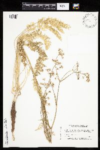 Carum carvi L. 440261[1034188]Myhre, K. 38901993-06-22 United States, Minnesota, Pine, Pine Co. Located 2 mi S of Sturgeon Lake. T45N R19W NE1/4 of SW1/4 of Sec 33;;045N;19W;33, 46.338863 -92.751249 |
MIN:Plants | 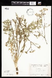 Carum carvi L. 446141[1034224]Moore, John; et al. 172901945-06-18 United States, Minnesota, Roseau, Roseau County...8 mi S of Roseau;;;;, 48.834515 -95.762766 |
MIN:Plants | 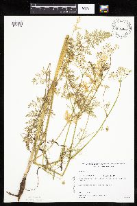 Carum carvi L. 448144[1034183]Gerdes, Lynden; et al. 34781999-06-23 United States, Minnesota, Cook, T65N R02W S19SENE. Cook Co. Superior National Forest. Northeast corner of the most southeastern bay of Gunflint Lake.;Superior National Forest;065N;02W;19, 48.098709 -90.630416 |
MIN:Plants |  Carum carvi L. 448936[1034206]Moore, John; Hall, Robert 163811944-06-09 United States, Minnesota, Pipestone, Pipestone Co.; village of Trosky;;105N;45W;, 43.892269 -96.245863 |
MIN:Plants |  Carum carvi L. 497536[1034212]Moore, John 202161949-06-21 United States, Minnesota, Lake of the Woods, near the mouth of Silver Creek W of Clementson;;N;;, 48.69578 -94.49092 |
MIN:Plants |  Carum carvi L. 531629[1034195]Bergman, H. s.n.1912-06-22 United States, Minnesota, Becker, Detroit;;N;;, 46.847559 -95.858616 |
MIN:Plants |  Carum carvi L. 554413[1034215]Moore, John 232591957-06-17 United States, Minnesota, Martin, 10 mi S of Fairmont;;N;;, 43.507331 -94.461083 |
MIN:Plants |  Carum carvi L. 554414[1034210]Moore, John 231671957-06-12 United States, Minnesota, Pipestone, Pipestone Co.; along rr at Woodstock;;106N;44W;, 43.979244 -96.124437 |
MIN:Plants |  Carum carvi L. 558417[1034205]Moore, John 238531958-06-12 United States, Minnesota, Kittson, along rr at Hallock;;N;;, 48.774426 -96.946447 |
MIN:Plants |  Carum carvi L. 560937[1034207]Ownbey, Gerald 27531959-06-30 United States, Minnesota, Clearwater, Itasca State Park, Biological Station;Itasca State Park;143N;36W;, 47.19557 -95.233216 |
MIN:Plants |  Carum carvi L. 572569[1034225]Moore, John; Baker, Gary 254631961-06-21 United States, Minnesota, Houston, Houston County...near upper end of Winnebago Valley, 3 mi SE of Caledonia;Dorer Memorial Hardwood State Forest;102N;05W;00, 43.630682 -91.431985 |
MIN:Plants |  Carum carvi L. 583263[1034193]Kellner, H. 4401956-07-20 United States, Minnesota, Cook, behind the stockade at Grand Portage;Grand Portage Indian Reservation / North Shore;063N;06E;, 47.958468 -89.703576 |
MIN:Plants |  Carum carvi L. 585337[1034197]Moore, John 262651963-05-22 United States, Minnesota, Blue Earth, 4 mi S of Mankato;;N;;, 44.105644 -93.9994 |
MIN:Plants |  Carum carvi L. 585564[1034216]Moore, John; et al. 260491962-06-08 United States, Minnesota, Houston, Houston County...3 mi SW of Caledonia;;;;, 43.631619 -91.501053 |
MIN:Plants |  Carum carvi L. 594173[1034214]Thorne, Robert 311741962-07-20 United States, Minnesota, Clearwater, by Ice House Pond, Campus of Univ. of Minnesota Biol. Sta, Itasca State Park;Itasca State Park;143N;36W;, 47.19557 -95.233216 |
MIN:Plants |  Carum carvi L. 603987[1034219]Moore, John; Hsi, Yu-tseng [Eugene] 272131967-06-19 United States, Minnesota, Winona, Lewiston;;106N;09W;, 43.977067 -91.899115 |
MIN:Plants |  Carum carvi L. 614613[1034198]Westkaemper, Remberta s.n.1969-06-00 United States, Minnesota, Stearns, Stearns Co. School grounds Raymond Twp, Sauk Center;;125N;35W;, 45.628667 -95.077451 |
MIN:Plants |  Carum carvi L. 708400[1034194]Manning, Sara s.n.1898-05-29 United States, Minnesota, Wabasha, Lake City;;N;;, 44.4081 -92.252454 |
MIN:Plants |  Carum carvi L. 724294[1034184]Smith, Welby 26861980-07-06 United States, Minnesota, Wright, Wright Co.; T121N, R26W, NW1/4 SW1/4 S10; S side of co rd 39, ca 1 1/4 mi WSW of Silver Creek;;121N;26W;10, 45.303961 -93.942892 |
MIN:Plants |  Carum carvi L. 834319[1034185]Monson, Paul 60921984-08-03 United States, Minnesota, Cook, Grand Portage National Monument. Cook Co. R-6E, T-63N, S-4, Visitor Center area;Grand Portage National Monument / North Shore;063N;06E;, 47.958468 -89.703576 |
MIN:Plants |  Carum carvi L. 908404[1034227]Gerdes, Lynden 54052007-06-18 United States, Minnesota, Lake, Superior National Forest. T60N R11W S08SWNWNE. Lake County, MN. Superior National Forest. Approximately 8.8 miles ESE of Babbitt, MN. Near the east side of FR 424E.. 060N 11W 8, 47.698978 -91.750445 |
MIN:Plants |  Carum carvi L. 917217[1034213]Gerdes, Lynden 55852008-07-07 United States, Minnesota, Saint Louis, Superior National Forest. T64N R12W S36SESW. St. Louis County, MN. Superior National Forest. Low Lake parking lot. Approximately 3.65 miles NNW of Winton, MN.. 064N 12W 36, 47.9788889 -91.8147222 |
MIN:Plants |  Carum carvi L. 494015[1034187]Smith, Welby 167971990-06-12 United States, Minnesota, Lake, Lake County ... Tetagouch [sic] State Park, about one mile southwest of Illgen City ...T56N R7W SE1/4 of NW1/4 of Sec 15;North Shore / Tettegouche State Park;056N;07W;15, 47.3375015 -91.2097244 |
MIN:Plants | 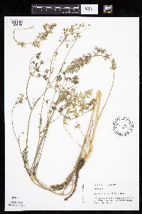 Carum carvi L. 493114[1034186]Mason, Harriet; et al. NSP98-351998-06-06 United States, Minnesota, Rice, Nerstrand Woods State Park. SW corner of sec. 16 in Nerstrand Big Woods State Park. Walking north along trail from snowmobile entrance. Near bat house.. 110N 19W 16, 44.334371 -93.111203 |
MIN:Plants | 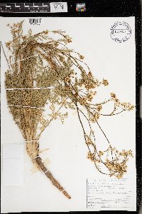 Carum carvi L. 978857[1401766]Don Henson 5491974-06-11 United States, Michigan, Delta, NW1/4 SW1/4 NW1/4 Sec 1 T38N R19W, 45.715045 -86.595244 |
MIN:Plants | 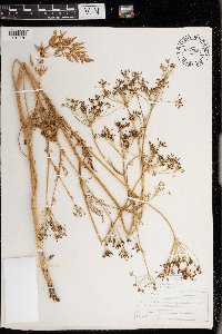 Carum carvi L. 978861[1401770]Don Henson 6611976-06-26 United States, Michigan, Delta, along many roads in the Garden Peninsula, 45.78772 -86.553658 |
1
Page 1, records 1-47 of 47
Google Map
Google Maps is a web mapping service provided by Google that features a map that users can pan (by dragging the mouse) and zoom (by using the mouse wheel). Collection points are displayed as colored markers that when clicked on, displays the full information for that collection. When multiple species are queried (separated by semi-colons), different colored markers denote each individual species.