University of Minnesota
http://www.umn.edu/
612-625-5000
http://www.umn.edu/
612-625-5000
Minnesota Biodiversity Atlas
Bell Museum
Dataset: MIN-Plants
Taxa: Chrysothamnus
Search Criteria: excluding cultivated/captive occurrences
1
Page 1, records 1-21 of 21
Bell Museum plants | |
 MIN:Plants | 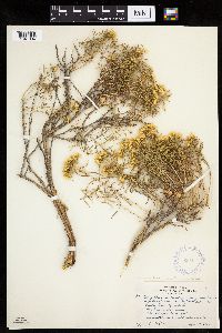 Chrysothamnus viscidiflorus subsp. viscidiflorus (Hooker) Nuttall 353437[1041384]Eggler, W.; Eggler, D. 2041936-08-16 United States, Idaho, Butte, Craters of the Moon National Monument. Butte County;Craters of the Moon National Monument;;;, 43.17714 -113.40637, 1707m |
MIN:Plants | 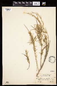 Chrysothamnus pulcherrimus A. Nels. 249510[1041379]Rydberg, P.; Garrett, A. 94391911-08-04 United States, Utah, San Juan, Armstrong and White Canyons, near the Natural Bridges;National Bridges National Monument, 1600 - 1800m |
MIN:Plants | 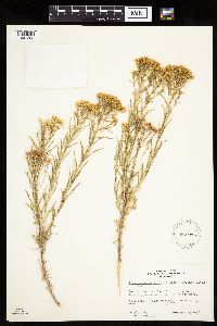 Chrysothamnus viscidiflorus subsp. viscidiflorus (Hooker) Nuttall 561935[1041383]McKnight, Anne 580725021958-07-25 United States, New Mexico, San Juan, San Juan Co. 1 mi. E. of Crystal, western flanks of Chuska Mtns.;Navaho Indian Reservation, 2195m |
MIN:Plants | 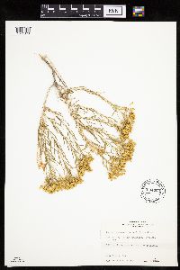 Chrysothamnus greenei (A. Gray) Greene 604282[1041378]Wright, Herb s.n.1961-00-00 United States, New Mexico, San Juan, Chuska Mountains. Toadlena dry lake...6 miles south of Toadlena.;Navaho Indian Reservation, 2134m |
MIN:Plants | 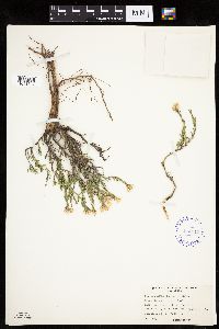 Chrysothamnus depressus Nuttall 414910[1041377]Harrison, B. 110401946-08-21 United States, Utah, Garfield, Bryce Canyon National Park...Garfield County;Bryce Canyon National Park |
MIN:Plants | 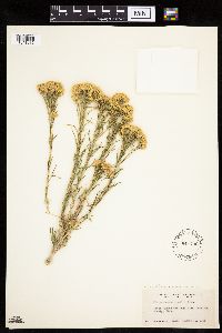 Chrysothamnus viscidiflorus subsp. viscidiflorus (Hooker) Nuttall 541792[1041382]Jones, George Neville 211131956-08-21 United States, Utah, Garfield, Bryce Canyon National Park, Garfield County;Bryce Canyon National Park |
MIN:Plants | 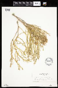 Chrysothamnus viscidiflorus (Hooker) Nuttall 604275[1041380]Wright, Herb s.n.1961-00-00 United States, New Mexico, San Juan, Chuska Mountains. Toadlena area;Navaho Indian Reservation, 2042m |
MIN:Plants | 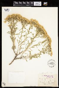 Chrysothamnus viscidiflorus subsp. lanceolatus (Nuttall) H.M. Hall & Clements 205230[1041381]Burglehaus, F. s.n.1894-09-04 United States, Wyoming, Park, Yellowstone Park...near Mammoth Hot Springs;Yellowstone National Park, 2134m |
MIN:Plants | Chrysothamnus viscidiflorus (Hooker) Nuttall 478560[]Bright, R. 71-61971-00-00 United States, Idaho, Franklin and Bannock cos. |
MIN:Plants |  Chrysothamnus viscidiflorus (Hooker) Nuttall 604276[1285390]Bent, Anne M. 59081101021959-08-11 United States, New Mexico, San Juan, Sheep Springs. 5 miles south. Route 789 between Newcomb and Naschitti.;Navaho Indian Reservation |
MIN:Plants | Chrysothamnus viscidiflorus (Hooker) Nuttall 478561[]Davis, Owen s.n.1978-08-29 United States, Idaho, Bingham, [no further data] |
MIN:Plants |  Chrysothamnus viscidiflorus subsp. viscidiflorus (Hooker) Nuttall 353438[1285393]Eggler, W. 3351938-08-04 United States, Idaho, Butte, Sunset Cone, Craters of the Moon National Monument. Craters of the Moon National Monument, 1798m |
MIN:Plants |  Chrysothamnus viscidiflorus subsp. puberulus (D. C. Eaton) H.M. Hall & Clements 794643[1285392]Schaaf, J. 901982-09-02 United States, Nevada, Esmeralda, US 95 MP 15, south of Goldfield, 1890m |
MIN:Plants |  Chrysothamnus viscidiflorus subsp. lanceolatus (Nuttall) H.M. Hall & Clements 205164[1285391]Baker, C. F. 6851901-08-01 United States, Colorado, Montrose, Region of the Gunnison Watershed...Black Canyon;Black Canyon of the Gunnison National Park, 2134m |
MIN:Plants |  Chrysothamnus viscidiflorus subsp. viscidiflorus (Hooker) Nuttall 353436[1285394]Eggler, W. 3281938-08-04 United States, Idaho, Butte, Sunset Cone, Craters of the Moon National Monument. Craters of the Moon National Monument, 1798m |
MIN:Plants |  Chrysothamnus ionensis Lunell 247766[1000626]Lunell, J. s.n.1903-07-16 United States, Oregon, Morrow, Ione |
MIN:Plants |  Chrysothamnus nauseosus var. nanus Cronquist 458386[1000627]Cronquist, A. 68121950-09-24 United States, Washington, Asotin, south rim of Blue Mts, about 2 miles west of Big Butte and 10 miles west of Anatone. Twp. 7N. R. 44E. About S.4, 1524m |
MIN:Plants |  Chrysothamnus pumilus var. latus A. Nelson 204816[1000628]Nelson, A. 12361911-07-20 United States, Idaho, Blaine, Ketchum, 1794m |
MIN:Plants | 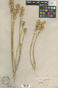 Chrysothamnus oreophilus var. artus A. Nelson 222270[1002796]Clark, J.A. 3171911-09-06 United States, Idaho, Ada, Boise, 878m |
MIN:Plants | 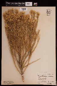 Chrysothamnus nauseosus (Pall.) Britton 950954[1290575]Stork, H. E. 3240 United States, Wyoming, Park, Yellowstone National Park |
MIN:Plants | Chrysothamnus depressus Nuttall []Wampler, C. GW13662002-07-29 United States, Colorado, Delta, Private property, along Rotcap Creek, Pitkin Mesa, 38.870528 -107.638472, 1808m |
1
Page 1, records 1-21 of 21
Google Map
Google Maps is a web mapping service provided by Google that features a map that users can pan (by dragging the mouse) and zoom (by using the mouse wheel). Collection points are displayed as colored markers that when clicked on, displays the full information for that collection. When multiple species are queried (separated by semi-colons), different colored markers denote each individual species.