University of Minnesota
http://www.umn.edu/
612-625-5000
http://www.umn.edu/
612-625-5000
Minnesota Biodiversity Atlas
Bell Museum
Dataset: MIN-Plants
Taxa: Cicuta
Search Criteria: excluding cultivated/captive occurrences
Bell Museum plants | |
 MIN:Plants | 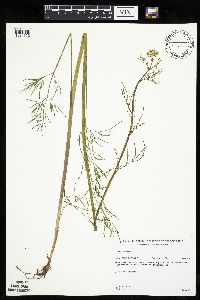 510909[1034352]Gerdes, Lynden 29671998-07-17 United States, Minnesota, Cook, West of Royal Lake and south of the Royal River;Boundary Waters Canoe Area Wilderness / Superior National Forest;064N;03E;02, 48.057888 -90.02419 |
MIN:Plants | 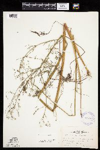 375202[1034353]Lakela, Olga 52031942-08-30 United States, Minnesota, Pine, south of Kerrick, Highway 23, Pine Co.;;044N;18W;03, 46.324166 -92.605381 |
MIN:Plants | 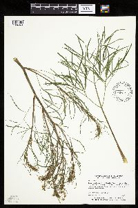 472800[1034349]Myhre, K. 60101995-08-07 United States, Minnesota, Aitkin, Aitkin County...Located one half mile southwest od Dam Lake...northeast bay of Long Lake...T 46N R 25W NE1/4 of SE1/4 of Sec 3. 046N 25W 3, 46.498121 -93.48411 |
MIN:Plants | 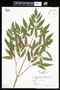 478937[1034547]Wheeler, Gerald 160751997-06-10 United States, Minnesota, Renville, Renville Co.; Ca. 3 mi. SE of Franklin on Rte. 5, S of road; S1/2 NW1/4 Sec. 20 T112N R33W (Camp 20);;112N;33W;20, 44.488589 -94.842347 |
MIN:Plants | 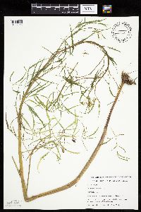 488803[1034356]Budelsky, R. RAB5291998-07-16 United States, Minnesota, Washington, Washington Co, T30N R21W S22;Saint Croix National Riverway;030N;21W;22, 45.072217 -92.913898 |
MIN:Plants | 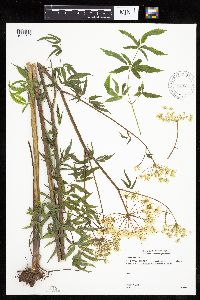 905637[1034543]Gerdes, Lynden 43882001-07-10 United States, Minnesota, Lake, T56N R08W S12NENE. Lake County...Silver Bay, MN. Approximately 0.27 miles north of Lax Lake.;North Shore;056N;08W;12, 47.350618 -91.293368 |
MIN:Plants | 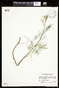 912696[1034318]Smith, Welby 231211993-07-28 United States, Minnesota, Grant, National Waterfowl Production Area. At the northwest end of Lee Lake, about six miles east of Elbow Lake (town).;Redhead Slough Wildlife Management Area;129N;41W;08, 45.9938889 -95.8583333 |
MIN:Plants | 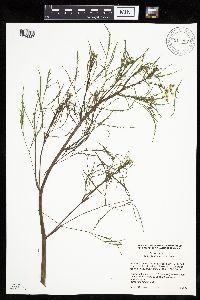 911907[1034337]Cholewa, A. 26662009-08-07 United States, Minnesota, Anoka, Martin-Island-Linwood Lakes County Park. Anoka County, Linwood Lake County Park, boat ramp at northeast end of lake, along man-made fishing peninsula west of ramp. T33N R22W Sec 9.. 033N 22W 9, 45.362784 -93.091567 |
MIN:Plants | 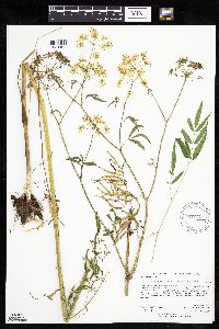 919600[1034404]Anderson, Derek 9902008-08-13 United States, Minnesota, Freeborn, Panicum Prairie Wildlife Management Area. Freeborn County...Panicum prairie WMA, ca. 3.5 km east of Interstate-35, on the Minnesota-Iowa border...T101N, R21W, SESE35. 101N 21W 35, 43.5013889 -93.3097222 |
MIN:Plants | 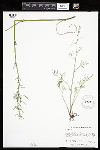 900995[1034254]Lee, Michael MDL41802005-09-15 United States, Minnesota, Becker, Becker County...Along the Otter Tail River, four miles north of Frazee...just downstream from the Wannigan Road bridge...T138N R40W NE1/4 of SW1/4 of NE1/4 Sec. 11. 138N 40W 11, 46.781101 -95.700537 |
MIN:Plants | 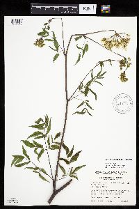 919337[1034518]Cholewa, A. 27522010-06-24 United States, Minnesota, Pine, 0.9 mile south of County Road 8 on Deer Valley Road. SW1/4 of section;;038N;20W;01, 45.809479 -92.785029 |
MIN:Plants | 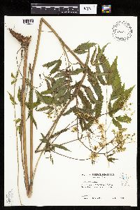 483886[1034462]Kaul, R. 65941989-07-08 United States, Minnesota, Hubbard, Hubbard Co.; along the north boundary road of Itasca Park, near LaSalle Creek.;Itasca State Park;143N;35W;, 47.195787 -95.107789 |
MIN:Plants |  360944[1034388]Hayden, Ada 104171934-08-10 United States, Iowa, Palo Alto, Palo Alto Co, Highland Twp, Sec. 6 ... Lost Island Lake near the inlet |
MIN:Plants |  101048[1122281]Aiton, G. s.n.1889-08-00 United States, Minnesota, Hennepin, [no further data];;;;, 45 -93.47 |
MIN:Plants |  163160[1034369]Aiton, G. s.n.1891-08-00 United States, Minnesota, Hennepin, Minneapolis;;029N;24W;25, 44.969959 -93.237021 |
MIN:Plants |  163170[1034371]Moyer, Lycurgus 26951895-08-15 United States, Minnesota, Pope, Lake Minnewaska;;N;;, 45.617836 -95.450645 |
MIN:Plants | 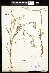 163171[1034286]Butters, F. s.n.1918-09-00 United States, Minnesota, Saint Louis, stream running into Burntside Lake;Superior National Forest;063N;13W;00, 47.932053 -91.987863 |
MIN:Plants | 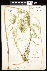 163172[1034326]Bergman, H. 29741914-08-04 United States, Minnesota, Hubbard, Benedict;;143N;32W;35, 47.15729 -94.6957 |
MIN:Plants | 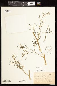 163173[1122284]Holzinger, John s.n.1884-07-00 United States, Minnesota, Winona, Winona;;N;;, 44.052588 -91.672687 |
MIN:Plants | 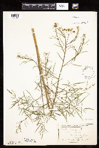 163174[1034257]Wheeler, William 6071899-08-24 United States, Minnesota, Houston, Brownsville;;103N;04W;, 43.71854 -91.317395 |
MIN:Plants |  163176[1034378]Johnson, A.; et al. s.n.1917-09-28 United States, Minnesota, Anoka, Moore Lake;;030N;24W;, 45.07639 -93.2475 |
MIN:Plants |  163177[1034280]Sheldon, Edmund S32091892-07-00 United States, Minnesota, Mille Lacs, Milaca;;037N;27W;, 45.692047 -93.698793 |
MIN:Plants |  163178[1034246]Taylor, B. T10031891-08-00 United States, Minnesota, Pope, Glenwood;;N;;, 45.650239 -95.389758 |
MIN:Plants |  163179[1034294]Herrick, C. s.n.1878-07-00 United States, Minnesota, Hennepin, Minneapolis;;N;;, 44.979965 -93.263836 |
MIN:Plants |  163180[1034364]Sandberg, John 10311885-09-09 United States, Minnesota, Winona, Winona;;107N;07W;, 44.052588 -91.672687 |
MIN:Plants |  163181[1034249]Ballard, C. B8261891-08-00 United States, Minnesota, Carver, Page Lake;;N;;, 44.82 -93.8 |
MIN:Plants |  163182[1034330]Sheldon, Edmund S33321892-08-00 United States, Minnesota, Otter Tail, Battle Lake;;133N;40W;, 46.32559 -95.717658 |
MIN:Plants |  163183[1034283]Sheldon, Edmund S33341892-08-00 United States, Minnesota, Otter Tail, Battle Lake;;133N;40W;, 46.32559 -95.717658 |
MIN:Plants |  163184[1034363]Sheldon, Edmund S39111892-08-00 United States, Minnesota, Otter Tail, Battle Lake;;133N;40W;00, 46.32559 -95.717658 |
MIN:Plants |  163185[1034291]Taylor, B. T16171892-08-00 United States, Minnesota, Washington, Marine Mills [original name for Marine-on-St. Croix];;;;, 45.198611 -92.769722 |
MIN:Plants |  163186[1122282]Leiberg, John 1878-10-01 United States, Minnesota, Blue Earth, [no further data];;;;, 44.03 -94.06 |
MIN:Plants |  163187[1034297]Ballard, C. B6771891-07-00 United States, Minnesota, Carver, Waconia;;116N;25W;, 44.8476 -93.827753 |
MIN:Plants | 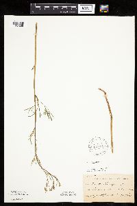 163188[1034328]Ballard, C. B7271891-07-00 United States, Minnesota, Carver, Benton, Carver Co.;;115N;25W;, 44.760626 -93.828251 |
MIN:Plants | 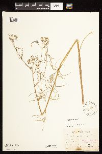 163189[1122283]Sandberg, John s.n.1886-08-00 United States, Minnesota, Goodhue, [no further data];;;;, 44.411962 -92.659575 |
MIN:Plants | 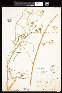 163190[1034285]MacMillan, C.; et al. 1831900-08-00 United States, Minnesota, Polk, Crookston;;150N;46W;30, 47.782 -96.60007 |
MIN:Plants | 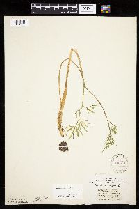 229690[1034375]Stork, H. s.n.1925-06-00 United States, Minnesota, Itasca, Bowstring;Chippewa National Forest;;;, 47.54306 -93.79639 |
MIN:Plants |  261954[1034368]Stork, H. 11531925-06-00 United States, Minnesota, Itasca, Bowstring;Chippewa National Forest;;;, 47.54306 -93.79639 |
MIN:Plants |  264364[1034282]Holzinger, John s.n.1901-06-00 United States, Minnesota, Winona, Lake [prob. Winona];;;;, 44.052588 -91.672687 |
MIN:Plants |  276176[1034295]Grant, Martin 31761929-08-27 United States, Minnesota, Clearwater, Itasca Park. Iron Springs. SW1/4 SW1/4 Sec. 28, T144N, R36W.;Itasca State Park;144N;36W;28, 47.260648 -95.244129 |
MIN:Plants |  277939[1034366]Roberts, Thomas s.n.1878-08-23 United States, Minnesota, Hennepin, Minneapolis;;N;;, 44.979965 -93.263836 |
MIN:Plants | 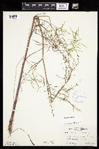 307030[1034327]Moyle, J. 20901935-09-06 United States, Minnesota, Scott, Near Savage;;N;;, 44.779131 -93.336336 |
MIN:Plants | 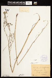 333553[1122286]Oestlund, O. 196-21888-08-15 United States, Minnesota, Hennepin, [no further data];;;;, 45 -93.47 |
MIN:Plants | 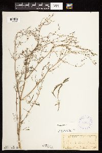 333653[1122285]Oestlund, O. s.n.1888-08-20 United States, Minnesota, Hennepin, [no further data];;;;, 45 -93.47 |
MIN:Plants | 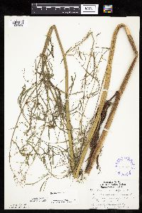 336654[1034319]Lakela, Olga 17481936-08-19 United States, Minnesota, Saint Louis, Minnesota Ave. at 21st. St, Duluth;;N;;, 46.76206 -92.08184 |
MIN:Plants |  345531[1034277]Lakela, Olga 23091937-08-27 United States, Minnesota, Saint Louis, John Kilpela's Farm, Palo;;057N;15W;, 47.415324 -92.239713 |
MIN:Plants |  348374[1034245]Buell, Murray; Buell, Helen 6411933-07-31 United States, Minnesota, Anoka, Decodon Pond;Cedar Creek National History Area;034N;23W;27, 45.406779 -93.193727 |
MIN:Plants |  360561[1034301]Lakela, Olga 41931940-09-01 United States, Minnesota, Saint Louis, St. Louis River terrace at Morgan Park, Duluth;;N;;, 46.692719 -92.203525 |
MIN:Plants |  361713[1034252]Butters, F.; et al. 65531934-09-06 United States, Minnesota, Aitkin, Farm Island Lake;;;;, 46.422051 -93.772021 |
MIN:Plants | 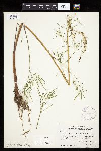 367068[1034332]Moore, John; et al. 103591938-08-28 United States, Minnesota, Saint Louis, N shore of Auto Lake. St. Louis Co.;Superior National Forest;;;, 47.739511 -92.362392 |
MIN:Plants | 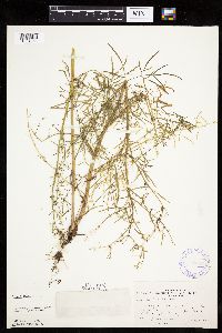 370707[1034261]Moore, John; et al. 137201940-10-01 United States, Minnesota, Isanti, Isanti County...W shore of Lory Lake, Maple Ridge Twp.;;;;, 45.721403 -93.358191 |
MIN:Plants | 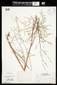 371109[1034247]Moore, John; et al. 136791940-09-28 United States, Minnesota, Anoka, Anoka County...E side of the lake, 1/2 mi. W of Bethel;;;;, 45.403853 -93.278041 |
MIN:Plants | 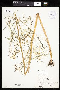 373825[1034362]Moore, John; et al. 151011941-08-09 United States, Minnesota, Hubbard, Hubbard County...11 mi. S of Hubbard Co. N border, along Hwy. 71 near Kabecona River;;;;, 47.24035 -94.87561 |
MIN:Plants |  380212[1034361]Lakela, Olga 54981943-09-11 United States, Minnesota, Saint Louis, Shore of and artificially made island in Superior Bay, Duluth;;N;;, 46.732162 -92.066301 |
MIN:Plants |  393498[1034372]Stevens, O. s.n.1947-09-19 United States, Minnesota, Clay, 7 mi. E of Barnesville;;N;;, 46.652087 -96.272157 |
MIN:Plants |  407547[1034299]Lakela, Olga 91221949-07-20 United States, Minnesota, Saint Louis, Prairie Lake;;050N;20W;, 46.809279 -92.870675 |
MIN:Plants |  409175[1034386]Moore, John; et al. 112911939-07-29 United States, Minnesota, Lake of the Woods, Along N shore of Magnuson Island. Lake of the Woods Co.;Northwest Angle;168N;34W;, 49.344621 -95.028893 |
MIN:Plants |  412404[1034325]Moore, John; et al. 119181939-08-19 United States, Minnesota, Koochiching, Koochiching County...E of Tilson Creek, Rainy Lake;;071N;23W;, 48.61383 -93.280482 |
MIN:Plants |  419729[1034250]Lakela, Olga 120361950-09-06 United States, Minnesota, Saint Louis, On Hwy. 216, E of Hibbing;;N;;, 47.427155 -92.937689 |
MIN:Plants |  419888[1034306]Lakela, Olga 117231950-08-25 United States, Minnesota, Saint Louis, Curtain Falls Resort, Crooked Lake;Boundary Waters Canoe Area Wilderness / Superior National Forest;066N;12W;, 48.186787 -91.869968 |
MIN:Plants |  421281[1034302]Lakela, Olga 122581950-09-22 United States, Minnesota, Saint Louis, Shore of Janet Lake, S of Hibbing on Hwy. 73;;N;;, 47.23954 -93.02004 |
MIN:Plants | 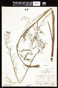 421516[1034298]Ahlgren, Clifford 9891950-08-17 United States, Minnesota, Lake, Boundary Waters Canoe Area Wilderness / Superior National Forest. Quetico Superior Wilderness Research Center. Lake Co. ... S shore of Pine Lake, [=Good Lake?] 1 mi. S of Hoist Bay of Basswood Lake. 064N 10W 21, 48.002752 -91.61836 |
MIN:Plants | 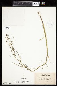 422620[1034329]Lakela, Olga 77751948-09-01 United States, Minnesota, Saint Louis, Shore of Comstock Lake, 37 mi. N of Duluth;Cloquet Valley State Forest;N;;, 47.220232 -92.223436 |
MIN:Plants | 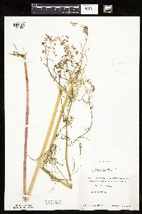 425990[1034304]Moyle, J. s.n.1951-08-17 United States, Minnesota, Roseau, Noracres swamp;;N;;, 48.9 -96.35 |
MIN:Plants | 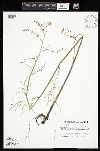 439550[1034228]Harris, Fred 931511993-08-31 United States, Minnesota, Polk, Polk Co. McIntosh Channel; NW1/4 SW1/4 Sec 27 T148N R41W. CBS site 84;;148N;41W;27, 47.607881 -95.864842 |
MIN:Plants | 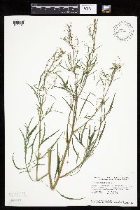 440698[1034272]Smith, Welby 148691988-08-17 United States, Minnesota, Meeker, Meeker County ... At the S end of Long Lake, about 1 mi N of Dassel ... at the public access ... SW1/4 SE1/4 sec. 22, T 119N R 29W. 119N 29W 22, 45.102806 -94.307072 |
MIN:Plants | 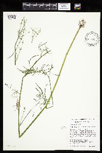 441740[1034344]Husveth, J. 06-2891996-09-05 United States, Minnesota, Wright, Hennepin Co. T119N R25W SE1/4 of the NE1/4 of S 2 [this locale is in Wright Co.];;119N;25W;2, 45.144089 -93.796362 |
MIN:Plants | 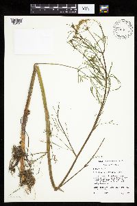 441741[1034345]Husveth, J. 95-15101995-08-04 United States, Minnesota, Hennepin, Hennepin Co. T118N R23W SW1/4 of the NE1/4 of S27;Wolsfeld Woods SNA;118N;23W;27, 44.999919 -93.573712 |
MIN:Plants | 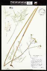 441742[1034347]Husveth, J. 95-1131995-08-07 United States, Minnesota, Wright, Wright Co, T120N R25W SE1/4 of the NW1/4 of s25;M Schmidt Crawford Woods Scientific Natural Area;120N;25W;25, 45.172755 -93.775987 |
MIN:Plants |  441743[1034346]Mensing, D. 95-9121995-08-23 United States, Minnesota, Carlton, Carlton Co. T49N R21W SE1/4 of the SW1/4 of S8; floodplain of the Little Tamarack River.;;049N;21W;8, 46.745401 -93.031191 |
MIN:Plants |  444743[1034374]Moore, John 197101947-08-07 United States, Minnesota, Morrison, Along the Crow Wing River, 6 mi. E of Hwy. 10;;N;;, 46.305183 -94.532443 |
MIN:Plants |  456567[1034342]Schimpf, D.; et al. 2151983-08-24 United States, Minnesota, Cook, Grand Portage National Monument; Cook Co. R-5E, T-64N, S-27, about 5.5 mi. NW of visitor center.;Grand Portage National Monument / North Shore;064N;05E;27, 47.99826 -89.791274 |
MIN:Plants |  457078[1034233]Smith, Welby 212251992-08-04 United States, Minnesota, Hennepin, Hennepin County ... about 1.5 miles southeast of Chanhassen ... T 116N R 22W NW1/4 of NE1/4 of sec. 19;;116N;22W;19, 44.8463898 -93.5077744 |
MIN:Plants |  457903[1122287]Sandberg, John 3971890-08-00 United States, Minnesota, Isanti, [no further data];;;;, 45.56 -93.29 |
MIN:Plants |  458825[1034387]Smith, Welby 147201988-08-04 United States, Minnesota, Benton, Sartell Wildlife Management Area. Benton County...Sartell State Wildlife Management Area, about 2 miles northeast of Rice; along Little Rice Creek; SW1/4 SW1/4 sec.15, T 38N R 31W. 038N 31W 15, 45.786582 -94.186232 |
MIN:Plants |  459463[1034385]Smith, Welby 143311988-06-25 United States, Minnesota, Aitkin, Long Lake Conservation Center, about 7.5 mi W-NW of McGregor; on the N side of Long Lake. SW1/4 of NW1/4 of section;<No data>;048N;25W;13, 46.6477778 -93.46 |
MIN:Plants |  476417[1034358]Sather, Nancy s.n.1995-08-14 United States, Minnesota, Mahnomen, White Earth Indian Reservation. Mahnomand Co.; at head of Roy Lake Creek just west of Mahnomen-Clearwater County line; County Biological Survey Site 112 Mahnomand Co.; at head of Roy Lake Creek just west of Mahnomen-Clearwater County line; County Biological Survey Site 112. T145 R39 NENE of Sec. 13. 145N 39W 13, 47.375765 -95.561718 |
MIN:Plants |  476423[1034315]Smith, Welby 181051990-08-28 United States, Minnesota, Carver, Raquet Wildlife Management Area. Carver Co. ... At the base of a south-facing bluff in the Minnesota River Valley, about 2 miles northwest of Shakopee ... T 116N R 23W NE1/4 of SW1/4 of Sec 35.. 116N 23W 35, 44.8111115 -93.5575027 |
MIN:Plants |  491693[1034239]Lakela, Olga 169441953-09-02 United States, Minnesota, Saint Louis, Trout Lake, N of Vermilion Lake;Boundary Waters Canoe Area Wilderness / Superior National Forest;N;;, 47.96483 -92.317289 |
MIN:Plants |  492949[1034238]Lakela, Olga 171271953-09-05 United States, Minnesota, Saint Louis, S of Trout Lake, N side of Vermilion Lake;;N;;, 47.96483 -92.317289 |
MIN:Plants |  500692[1034365]Harris, S. 320a1953-06-22 United States, Minnesota, Marshall, Plot 5. Mud River Pool, Mud Lake National Wildlife Refuge;Agassiz National Wildlife Refuge;N;;, 48.348185 -95.955105 |
MIN:Plants | 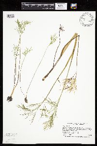 504881[1034312]Smith, Welby 170381990-06-25 United States, Minnesota, Steele, Pogones Wildlife Management Area. Steele County ... Pogones State Wildlife Management Area, about 12 mi S-SE of Owatonna ... T 105N R 19W NW1/4 of SE1/4 of Sec 18. 105N 19W 18, 43.8977776 -93.2783356 |
MIN:Plants | 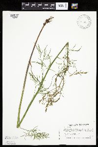 514281[1034234]Smith, Welby 212941992-08-10 United States, Minnesota, Wadena, Wadena County ... between Trunk Highway 10 and the Burlington Northern Railroad tracks, on the E side of Wadena (town) ... T134N R35W NE1/4 of NW1/4 of sEc 8. 134N 35W 8, 46.4388885 -95.1263885 |
MIN:Plants | 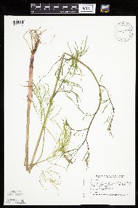 514292[1034237]Smith, Welby 211731992-07-31 United States, Minnesota, Le Sueur, Le Sueur County ... at the Send of Fish Lake, about 2 miles N of Elysian ... T109N R24W SE1/4 of SE1/4 of Sec 23;;109N;24W;23, 44.2272224 -93.6699982 |
MIN:Plants | 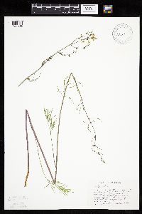 515827[1034360]Scott, P. 7291994-08-25 United States, Minnesota, Cook, Cook Co. by road 1378 just S of North Brule River crossing, Superior N.F. T64N R1W sec.23.;Superior National Forest;064N;01W;23, 48.011848 -90.415793 |
MIN:Plants | 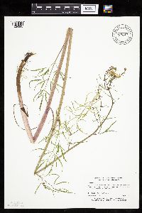 515843[1034343]Myhre, K. 29031992-08-03 United States, Minnesota, Cass, Cass Co.; Located on Ottertail Peninsula in Leech Lake; T 143N R 29W NE1/4 of SE1/4 of Sec 1;;143N;29W;1, 47.233228 -94.297593 |
MIN:Plants | 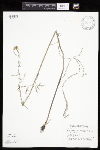 518987[1034339]Puchalski, L. 3761993-08-10 United States, Minnesota, Polk, Polk Co.; T 150N R 39W NW1/4 of SE1/4 of SEc 22;;150N;39W;22, 47.797388 -95.633726 |
MIN:Plants | 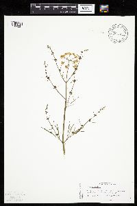 519329[1034231]Scott, P. 8341995-08-12 United States, Minnesota, Cook, Cook Co. Outlet stream of Trap Lake near the Gunflint Trail. T64NR1E sec.18 or 19.;Superior National Forest;064N;01E;, 48.01924 -90.317932 |
MIN:Plants | 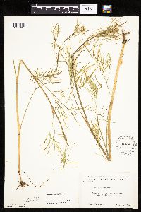 526306[1034305]Moore, John 213111951-08-09 United States, Minnesota, Douglas, Along the E arm of Lake Christina;;N;;, 46.090549 -95.736412 |
MIN:Plants | 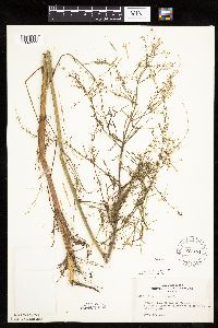 527461[1034377]Anonymous 184571954-09-18 United States, Minnesota, Lake, bay of Basswood Lake at Quetico-Superior Wilderness Research Center.;Boundary Waters Canoe Area Wilderness / Superior National Forest;064N;10W;09, 48.031651 -91.618862 |
MIN:Plants | 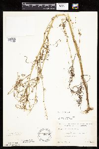 528175[1034303]Lakela, Olga 195021955-09-12 United States, Minnesota, Saint Louis, Sand Lake N of Virginia;Superior National Forest;N;;, 47.648931 -92.635203 |
MIN:Plants | 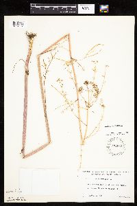 532664[1034307]Lakela, Olga 211201956-09-14 United States, Minnesota, Saint Louis, Prairie River shore marsh, near the bridge on Hwy. 51, W of Prairie Lake.;;N;;, 46.809279 -92.870675 |
MIN:Plants | 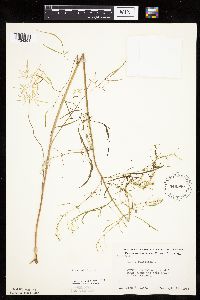 549980[1034251]Moore, John 220471954-09-14 United States, Minnesota, Sherburne, Along the W shore of Lake Fremont;;N;;, 45.45641 -93.576516 |
MIN:Plants |  553723[1034276]Moore, John 226761955-07-27 United States, Minnesota, Clay, Barnesville;;N;;, 46.652182 -96.41979 |
MIN:Plants |  566401[1034248]Moore, John; Heig, V. 241861958-09-12 United States, Minnesota, Kittson, Border of Twin Lake;Twin Lakes Wildlife Management Area;N;;, 48.628405 -96.431874 |
MIN:Plants |  566766[1034384]Marion, J. s.n.1982-00-00 United States, Minnesota, Cook, Cook Co, North Shore of Lake Superior, ca. 200 ft. from lakeshore.;North Shore;N;;, 47.46396 -91.02551 |
MIN:Plants |  574618[1034244]Moore, John 247261959-07-29 United States, Minnesota, Kittson, Below the dam at Bronson State Park;Lake Bronson State Park;161N;46W;, 48.760365 -96.602054 |
MIN:Plants | 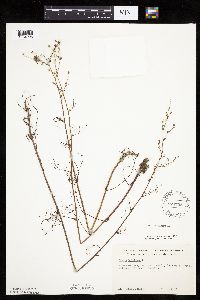 576795[1034296]Isaak, Daniel s.n.1959-09-19 United States, Minnesota, Isanti, Horseshoe Lake, Sec. 2 and 11, T34N and R22W;;N;;, 45.427323 -93.081077 |
MIN:Plants | 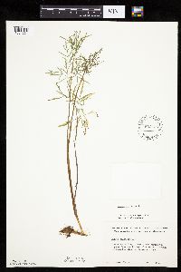 582435[1034331]Isaak, Daniel s.n.1958-00-00 United States, Minnesota, Clearwater, Itasca State Park. Swamp area across the hwy. from the biological station;Itasca State Park;143N;36W;, 47.19557 -95.233216 |
MIN:Plants | 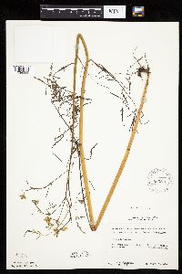 583873[1034334]Gunderson, R. 5761961-08-06 United States, Minnesota, Washington, Washington County ... St. Croix River. 3 mi. N of Stillwater. S shore [of island?];Saint Croix National Riverway;030N;20W;, 45.084979 -92.817348 |
MIN:Plants | 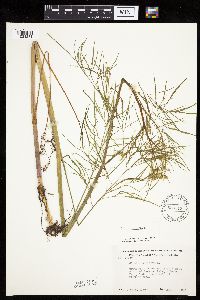 586513[1034281]Moore, John 264351963-08-07 United States, Minnesota, Isanti, 1/2 mi. N of Beckman Lake, Athens Twp, Cedar Creek Natural Area.;Cedar Creek National History Area;034N;23W;, 45.428063 -93.203997 |
Google Map
Google Maps is a web mapping service provided by Google that features a map that users can pan (by dragging the mouse) and zoom (by using the mouse wheel). Collection points are displayed as colored markers that when clicked on, displays the full information for that collection. When multiple species are queried (separated by semi-colons), different colored markers denote each individual species.