University of Minnesota
http://www.umn.edu/
612-625-5000
http://www.umn.edu/
612-625-5000
Minnesota Biodiversity Atlas
Bell Museum
Dataset: MIN-Plants
Taxa: Commelina
Search Criteria: excluding cultivated/captive occurrences
1
Page 1, records 1-13 of 13
Bell Museum plants | |
 MIN:Plants | 491994[]Stevens, O. s.n.1953-08-27 United States, Minnesota, Cass, Woman Lake;;140N;28W;, 46.934801 -94.216123 |
MIN:Plants | 497334[]Monson, George 3591946-07-21 United States, Minnesota, Hennepin, 40th and Beard South, Minneapolis.;;N;;, 44.93048 -93.32401 |
MIN:Plants | 568927[]Moore, John; et al. 251731960-07-15 United States, Minnesota, Anoka, Old farm site at entrance to Cedar Creek Forest Area Laboratory Grounds.;Cedar Creek Ecosystem Preserve;034N;23W;, 45.428063 -93.203997 |
MIN:Plants | 681698[]Gustitus, J. 681973-10-06 United States, Minnesota, Dakota, Hastings, by a farmhouse near the river.;;N;;, 44.743301 -92.852427 |
MIN:Plants | 721361[]Benson, Douglas 161980-08-13 United States, Minnesota, Ramsey, Ramsey Co.; Loading dock at the Murphy warehouse area, Kasota Avenue, St. Paul.;;029N;23W;, 44.992077 -93.166387 |
MIN:Plants | 458720[]Lee, Michael; et al. United States, Minnesota, Wabasha, Detailed locality information protected. This is typically done to protect rare or threatened species localities. |
MIN:Plants | 751022[]Galatowitsch, S. United States, Minnesota, Wabasha, Detailed locality information protected. This is typically done to protect rare or threatened species localities. |
MIN:Plants | 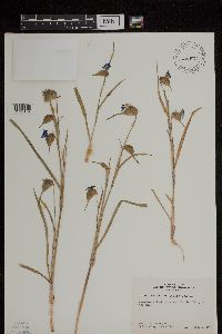 Commelina dianthifolia Delile 464571[1299154]Ownbey, Gerald; et al. 17901953-09-01 United States, Arizona, Cochise, Cochise Co.: near Rustler Peak |
MIN:Plants | Commelina crispa Wooton 85093[1000691]Wooton, E.O. United States, New Mexico, Dona Ana, Detailed locality information protected. This is typically done to protect rare or threatened species localities. |
MIN:Plants | 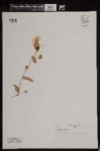 953766[1294719]Rogge, Janet 30 United States, South Dakota, Minnehaha |
MIN:Plants | 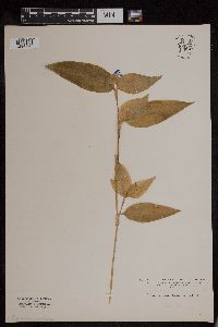 953765[1294720]Wible, Paul G. s.n.1928-07-02 United States, Indiana, Lawrence, Northeastern Lawrence County |
MIN:Plants | 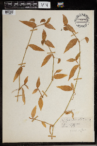 965887[1356647] 1944-07-22 United States, District of Columbia, Harewood Road above Retreat House |
MIN:Plants | 0967751[1368304] United States, Texas, Detailed locality information protected. This is typically done to protect rare or threatened species localities. |
1
Page 1, records 1-13 of 13
Google Map
Google Maps is a web mapping service provided by Google that features a map that users can pan (by dragging the mouse) and zoom (by using the mouse wheel). Collection points are displayed as colored markers that when clicked on, displays the full information for that collection. When multiple species are queried (separated by semi-colons), different colored markers denote each individual species.