University of Minnesota
http://www.umn.edu/
612-625-5000
http://www.umn.edu/
612-625-5000
Minnesota Biodiversity Atlas
Bell Museum
Dataset: MIN-Plants
Taxa: Cymopterus
Search Criteria: excluding cultivated/captive occurrences
1
Page 1, records 1-8 of 8
Bell Museum plants | |
 MIN:Plants | Cymopterus globosus (S. Watson) S. Watson 491084[]Williams, M. s.n.1982-00-00 United States, Nevada, Douglas, Pine Nut Range, Douglas Co. |
MIN:Plants | 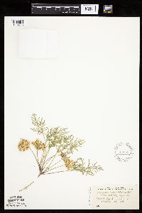 Cymopterus acaulis var. acaulis (Pursh) Rafinesque 580361[1034796]Stevens, O. 21881960-06-11 United States, Minnesota, Clay, Glyndon, Clay Co.;;139N;47W;11, 46.869895 -96.578669 |
MIN:Plants | 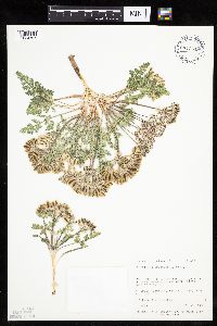 Cymopterus bulbosus A. Nelson 713619[1034797]Neese, E.; et al. 45731978-05-15 United States, Utah, Uintah, Uintah Co. ... T9S, R20E, NE 1/4 of Sec 17, 3.6 mi S of Ouray Bridge on the Green River.;;009S;20E;17, 1463m |
MIN:Plants | 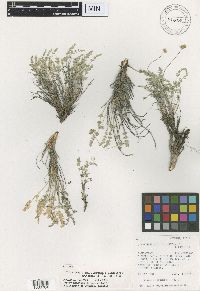 Cymopterus evertii Hartman & Kirkpatrick 814785[1000764]Hartman, R.L. 127991981-05-27 United States, Wyoming, Park, T48N R99W S35. Bighorn Basin: N side of Squaw Teats Road, 2 air mi E of Wy 120, ca 10 air mi SE of Meeteetse, 1798m |
MIN:Plants | 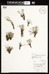 Cymopterus evertii Hartman & Kirkpatrick 814786[1127764]Kirkpatrick, R.S. 34441984-07-03 United States, Wyoming, Park, T50N R103W S19. Southeastern Absaroka Mountains, ca 30.5 air km SW of Cody, ca 1.6 km E of Belknap Cr, in the vicnity of "Peak 8981", NW 1/4 Sec 19., 2700m |
MIN:Plants |  Cymopterus evertii Hartman & Kirkpatrick 814789[1127765]Hartman, R.L. 170001983-08-20 United States, Wyoming, Park, T50N R103W S26. Southeastern Absarokas: Foster Draw, ca 1 mi W of Fosters Reservoir, NE end of Carter Mountain, 274m |
MIN:Plants | Cymopterus lemmonii (J.M. Coult. & Rose) Dorn []Prenot, C. GW24582005-06-29 United States, Colorado, Gunnison, Kebler Pass Road near Marcellina Mountain, Gunnison National Forest, 38.910056 -107.240528, 2590m |
MIN:Plants | Cymopterus lemmonii (J.M. Coult. & Rose) Dorn []Olson, Emily GW25972004-08-07 United States, Colorado, Gunnison, Along the trail towards Frigid Air Pass, 15 min. (hiking) after leaving trail, 39.053601 -107.020324, 3642m |
1
Page 1, records 1-8 of 8
Google Map
Google Maps is a web mapping service provided by Google that features a map that users can pan (by dragging the mouse) and zoom (by using the mouse wheel). Collection points are displayed as colored markers that when clicked on, displays the full information for that collection. When multiple species are queried (separated by semi-colons), different colored markers denote each individual species.