University of Minnesota
http://www.umn.edu/
612-625-5000
http://www.umn.edu/
612-625-5000
Minnesota Biodiversity Atlas
Bell Museum
Dataset: MIN-Plants
Taxa: Galinsoga
Search Criteria: excluding cultivated/captive occurrences
1
Page 1, records 1-36 of 36
Bell Museum plants | |
 MIN:Plants | 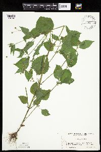 Galinsoga quadriradiata Ruiz & Pav 499085[1045116]Cholewa, A. 26492003-08-10 United States, Minnesota, Anoka, Anoka County, City of Blaine, T 31N R 23W Sec. 8.;;031N;23W;08, 45.189898 -93.234832 |
MIN:Plants | 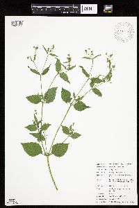 Galinsoga quadriradiata Ruiz & Pav 911736[1045131]Chayka, K. KC-09162009-08-23 United States, Minnesota, Ramsey, Battle Creek County Park. Ramsey County...Battle Creek West Regional Park, St. Paul; both sides of Battle Creek Rd, starting about 50 ft north of Lower Afton Rd. 028N 22W 3, 44.935088 -93.020049 |
MIN:Plants | 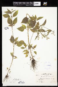 Galinsoga parviflora var. parviflora Cavanilles 381082[1045113]Moore, John 156471942-08-03 United States, Minnesota, Hennepin, Minneapolis;;N;;, 44.979965 -93.263836 |
MIN:Plants | 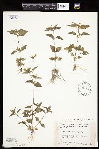 Galinsoga parviflora var. parviflora Cavanilles 448568[1045112]Moore, John; Huff, N. 177731945-07-23 United States, Minnesota, Morrison, Below the dam at Little Falls;;N;;, 45.976354 -94.362502 |
MIN:Plants | 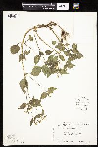 Galinsoga parviflora var. parviflora Cavanilles 566544[1045109]Moore, John 233451958-10-06 United States, Minnesota, Blue Earth, 1/2 mi below Rapidan Dam;;N;;, 44.08439 -94.108568 |
MIN:Plants | 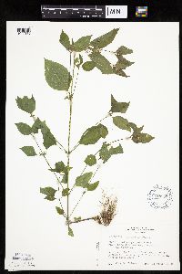 Galinsoga parviflora var. parviflora Cavanilles 618957[1045110]Thieret, J. 336181970-08-22 United States, Minnesota, Clearwater, In front of building in which entomology is taught, Biological Station, Itasca State Park;Itasca State Park;143N;36W;, 47.19557 -95.233216 |
MIN:Plants | 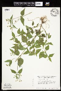 Galinsoga parviflora var. parviflora Cavanilles 724212[1045111]Smith, Welby 34601980-08-23 United States, Minnesota, Wright, Wright Co.; T120N R23W; NE1/4 NE1/4 sec.18. About 2 mi E of jnc. of hwy. 241 and 19 in St. Michael. Crow River.;;120N;23W;18, 45.201296 -93.635461 |
MIN:Plants | 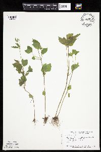 Galinsoga parviflora var. parviflora Cavanilles 770595[1045108]Smith, Welby 84291983-07-26 United States, Minnesota, Mower, Lake Louise State Park, about 1.5 mi NW of LeRoy. N bank of the Iowa River. NE1/4 NW1/4 sec.28, T101N R14W;Lake Louise State Park;101N;14W;28, 43.522099 -92.518958 |
MIN:Plants |  Galinsoga quadriradiata Ruiz & Pav 208731[1045124]Illegible name s.n.1909-09-20 United States, Minnesota, Washington, White Bear Lake;;030N;22W;, 45.079894 -93.045502 |
MIN:Plants |  Galinsoga quadriradiata Ruiz & Pav 407155[1045123]Lakela, Olga 95361949-08-29 United States, Minnesota, Saint Louis, Lake Kabetogama, near Gappas Landing, St. Louis Co.;Voyageurs National Park;N;;, 48.437695 -93.027374 |
MIN:Plants |  Galinsoga quadriradiata Ruiz & Pav 440388[1045114]Smith, Welby 149531988-08-23 United States, Minnesota, Houston, Houston Co. About 1 mi E of Rushford; SE1/4 NE1/4 sec.18, T104N R7W;Dorer Memorial Hardwood State Forest;104N;07W;18, 43.810366 -91.720423 |
MIN:Plants |  Galinsoga quadriradiata Ruiz & Pav 443222[1045120]Lakela, Olga 139031951-10-19 United States, Minnesota, Saint Louis, Fifth Ave. E. Superior St. Duluth.;;N;;, 46.79627 -92.09929 |
MIN:Plants | 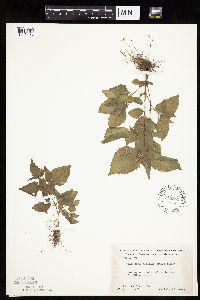 Galinsoga quadriradiata Ruiz & Pav 448565[1045126]Moore, John 177761945-07-23 United States, Minnesota, Morrison, Morrison Co.; Below the dam at Little Falls;;N;;, 45.976354 -94.362502 |
MIN:Plants | 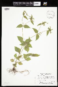 Galinsoga quadriradiata Ruiz & Pav 459680[1045117]Myhre, K. 29571992-08-05 United States, Minnesota, Cass, Cass Co.; Located on the southern end of Ottertail Penninsula in Leech Lake; T 143N R 30W SE1/4 of SE1/4 of Sec 2;Chippewa National Forest / Leech Lake Indian Reservation;143N;30W;2, 47.221512 -94.416757 |
MIN:Plants | 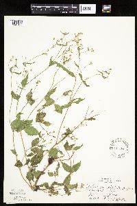 Galinsoga quadriradiata Ruiz & Pav 541351[1045122]Huff, N. s.n.1953-09-03 United States, Minnesota, Hennepin, Minneapolis;;N;;, 44.979965 -93.263836 |
MIN:Plants | 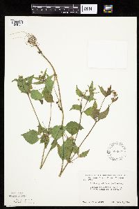 Galinsoga quadriradiata Ruiz & Pav 585387[1045121]Moore, John 261971962-10-02 United States, Minnesota, Houston, Houston Co.; 2 mi S of LaCrescent;;N;;, 43.823801 -91.308917 |
MIN:Plants | 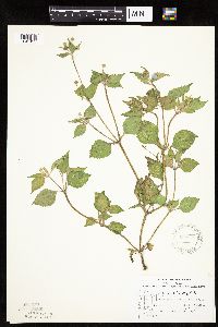 Galinsoga quadriradiata Ruiz & Pav 588828[1045129]Stevens, O. 27551964-08-29 United States, Minnesota, Cass, Cass Co.; Squaw Point, Leech Lake, N of Walker;Chippewa National Forest / Leech Lake Indian Reservation;143N;31W;24, 47.185588 -94.547998 |
MIN:Plants | 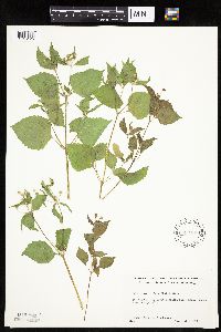 Galinsoga quadriradiata Ruiz & Pav 592406[1045125]Westkaemper, Remberta s.n.1962-07-00 United States, Minnesota, Stearns, Stearns Co. St. Cloud. St. Cloud Hospital river bank.;;N;;, 45.55493 -94.17068 |
MIN:Plants | 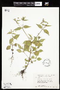 Galinsoga quadriradiata Ruiz & Pav 603600[1045128]Moore, John; Moore, Marjorie 269761966-09-29 United States, Minnesota, Anoka, Anoka Co.; At farmsted S side of Fish Lake, Cedar Creek Natural History Area;Cedar Creek National History Area;034N;23W;, 45.428063 -93.203997 |
MIN:Plants | 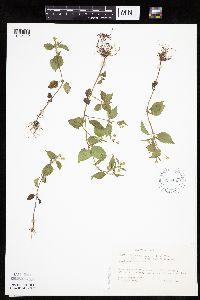 Galinsoga quadriradiata Ruiz & Pav 630433[1045119]Thieret, J. 448511973-08-17 United States, Minnesota, Clearwater, At house of resident manager, Biological Station, Lake Itasca, Itasca State Park. Clearwater Co.;Itasca State Park;143N;36W;, 47.19557 -95.233216 |
MIN:Plants |  Galinsoga quadriradiata Ruiz & Pav 696774[1045127]Smith, Welby 6141978-09-04 United States, Minnesota, Wright, Wright Co. T121N, R27W, SW1/4 sec.9. Between state hwy. 24 and Clearwater Lake.;;121N;27W;9, 45.301091 -94.091494 |
MIN:Plants |  Galinsoga quadriradiata Ruiz & Pav 728949[1045130]Berlin, N. 981979-07-10 United States, Minnesota, Goodhue, Goodhue Co. Wacouta Pond Natural Area: 5 mi SE of Red Wing. Portions of T112N, R13W and T113N, R13W.;Wacouta Pond Natural Area, The Nature Conservancy;N;;, 44.511242 -92.461936 |
MIN:Plants |  Galinsoga quadriradiata Ruiz & Pav 745247[1045118]Smith, Welby 46921981-07-07 United States, Minnesota, Fillmore, Fillmore Co.; bank of the Root River, about 1 mi W of Peterson. NW1/4 NE1/4 sec.31, T104N R8W;;104N;08W;31, 43.767571 -91.840152 |
MIN:Plants |  Galinsoga quadriradiata Ruiz & Pav 842041[1045115]Smith, Welby 150011988-08-30 United States, Minnesota, Washington, Washington County ... About 2 mi NE of Stillwater ... Highway 95. NW1/4 NW1/4 sec.14, T30N R20W;Saint Croix National Riverway;030N;20W;14, 45.090515 -92.777311 |
MIN:Plants | 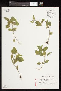 Galinsoga parviflora var. parviflora Cavanilles 922203[1127516]Smith, Welby 232301993-07-29 United States, Minnesota, Douglas, Lake Carlos State Park. In Lake Carlos State Park, on the west side of Hidden Lake about 6 miles north of Alexandria... T 129N R 37W SW1/4 of SW1/4 of Sec 9. 129N 37W 9, 45.9958333 -95.3469444 |
MIN:Plants | 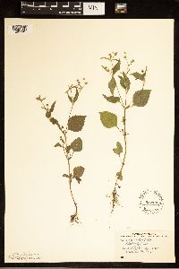 Galinsoga quadriradiata Ruiz & Pav 552199[1285949]Stevens, O. 20271958-08-27 United States, Minnesota, Clay, Moorhead;;129N;048N;09, 46.869329 -96.746718 |
MIN:Plants | 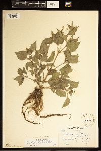 Galinsoga quadriradiata Ruiz & Pav 208759[1285948]Butters, F. 12741903-06-29 United States, Minnesota, Hennepin, Mr. Butters' garden. Minneapolis.;;029N;24W;, 44.991926 -93.288153 |
MIN:Plants | 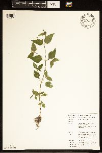 Galinsoga parviflora var. parviflora Cavanilles 942624[1285947]Chayka, K.; Dziuk, P. 14062014-08-30 United States, Minnesota, Anoka, East side of foot path into Blaine Preserve SNA;;031N;23W;26, 45.1388694 -93.1759861 |
MIN:Plants | 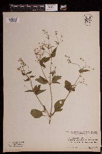 Galinsoga parviflora Cavanilles 953546[1293022]Heimerl s.n.1923-08-27 Austria |
MIN:Plants | 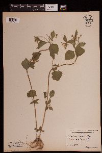 Galinsoga parviflora Cavanilles 953544[1293024]Stork, H. E. s.n.1917-07-11 United States, New York, Tompkins, Buttermilk Gorge [Buttermilk Falls State Park] |
MIN:Plants | 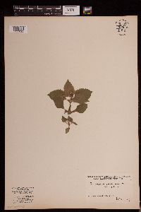 953545[1293023]Linnell, Bertha s.n.1927-07-00 United States, Maine, York, Saco |
MIN:Plants | 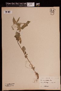 Galinsoga parviflora Cavanilles 953543[1293025]Stork, H. E. s.n. United States, New York, Tompkins, Buttermilk Gorge [Buttermilk Falls State Park] |
MIN:Plants | 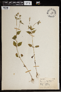 Galinsoga parviflora Cavanilles 965869[1356628] 1944-08-05 United States, District of Columbia, Harewood Road in front of Retreat House |
MIN:Plants | 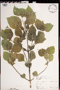 Galinsoga ciliata (Raf.) S.F. Blake 971339[1394820]Janssens, J. 75/2151975-07-25 Belgium, Kiel |
MIN:Plants | 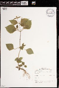 Galinsoga ciliata (Raf.) S.F. Blake 971371[1394852]Verbelen, E. 2221974-06-29 Belgium, Kiel |
MIN:Plants | 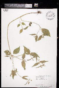 Galinsoga quadriradiata Ruiz & Pav 973615[1397169]Bezanson, Char A. 2821991-09-04 United States, Minnesota, Rice, Residential area of Northfield., 44.449667 -93.170848 |
1
Page 1, records 1-36 of 36
Google Map
Google Maps is a web mapping service provided by Google that features a map that users can pan (by dragging the mouse) and zoom (by using the mouse wheel). Collection points are displayed as colored markers that when clicked on, displays the full information for that collection. When multiple species are queried (separated by semi-colons), different colored markers denote each individual species.