University of Minnesota
http://www.umn.edu/
612-625-5000
http://www.umn.edu/
612-625-5000
Minnesota Biodiversity Atlas
Bell Museum
Dataset: MIN-Plants
Taxa: Grindelia
Search Criteria: excluding cultivated/captive occurrences
Bell Museum plants | |
 MIN:Plants |  Grindelia squarrosa (Pursh) Dunal 505479[1045250]Gerdes, Lynden 49642004-10-01 United States, Minnesota, Lake, Superior National Forest. T60N R10W S32NWNE Lake County ...Superior National Forest. Approximately 12.91 miles WNW of Isabella, MN and 0.10 mile NW of Wampus Lake. Approximately 75 m south of the Hwy. 2 & FR 112 junction along the west shoulder of Hwy.2.. 060N 10W 32, 47.640072 -91.629443 |
MIN:Plants |  Grindelia squarrosa (Pursh) Dunal 264212[1045212]Holzinger, John s.n.1905-08-00 United States, Minnesota, Winona, in C.N.W. Ry yards...in Winona County;;;;, 43.997785 -91.748027 |
MIN:Plants |  Grindelia squarrosa (Pursh) Dunal 604195[1045251]Wright, Herb s.n.1961-00-00 United States, New Mexico, San Juan, Chuska Mountains. Toadlena landslide lake ... 6 miles south of Toadlena;Navaho Indian Reservation, 2134m |
MIN:Plants |  Grindelia squarrosa (Pursh) Dunal 490546[1045192]Juhnke, C. 508 CMJ FRO1999-08-05 United States, Minnesota, Goodhue, Frontenac State Park Goodhue County ... Along railroad tracks at southeast border of park ..T112N R13W SE SW NE14;Frontenac State Park;112N;13W;14, 44.505485 -92.339405 |
MIN:Plants |  Grindelia squarrosa (Pursh) Dunal 738142[1045224]Lounsbury, S. 191977-09-01 United States, Minnesota, Saint Louis, St. Louis Co. R. 15W T. 48N Sec. 11 S. Mud Lake. R.R. grade ... St. Louis R. Estuary Waterfront Trail Area;;048N;15W;11, 46.657154 -92.210134 |
MIN:Plants |  Grindelia hirsutula Hooker & Arnott 386239[1045180]Lakela, Olga 59111944-09-08 United States, Minnesota, Saint Louis, Along Grand Rapids Highway about 19 miles from Duluth. St. Louis Co.;;;;, 46.848926 -92.510381 |
MIN:Plants |  Grindelia squarrosa (Pursh) Dunal 426951[1045223]Whitfeld, T.J.S. 3042001-08-22 United States, Minnesota, Kandiyohi, Brenner Lake Wildlife Management Area. Kandiyohi County...Roadside next to State Hwy. 104; 1/2 miles south of Pope/Kandiyohi county line. In parking area for Brenner Lake WPA...T122N R36W SW1/4 of SW1/4 of NW1/4 of Section 6.. 122N 36W 6, 45.405551 -95.244872 |
MIN:Plants |  Grindelia squarrosa (Pursh) Dunal 498909[1045197]Wheeler, Gerald 178901997-09-21 United States, Minnesota, Renville, Renville County...Ca. 1.5 mi. W of Hector on Rte. 212, N of road; S1/2 S1/2 Sec. 19 T115n R32W (Hector 19);;115N;32W;19, 44.75333 -94.7419 |
MIN:Plants | 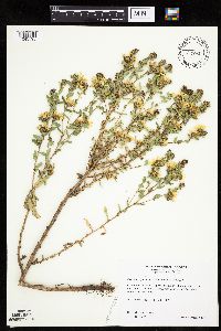 Grindelia squarrosa (Pursh) Dunal 477045[1045195]Wheeler, Gerald 178821997-09-20 United States, Minnesota, Chippewa, Chippewa County ... Ca. 4 mi. W of Milan; Chippewa Prairie ... near Lac Qui Parle Lake ... W1/2 SE1/4 Sec. 13 T119N R43W;Chippewa Prairie, The Nature Conservancy;119N;43W;13, 45.110235 -95.996766 |
MIN:Plants | 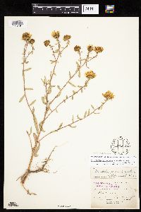 Grindelia hirsutula Hooker & Arnott 209216[1045191]Burglehaus, F. s.n.1894-08-03 United States, Wyoming, Park, Yellowstone Park ... Near Mammoth Hot Springs;Yellowstone National Park, 2134m |
MIN:Plants | 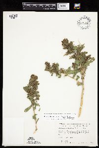 Grindelia squarrosa (Pursh) Dunal 709720[1045211]Wheeler, Gerald 47291979-08-03 United States, Minnesota, Lac Qui Parle, Lac Qui Parle County...Approx. 1 mi east of Nassau on Route 24...near the junction of Routes 7 and 24. T119N R46W Sec 33;;;;, 45.073479 -96.424847 |
MIN:Plants | 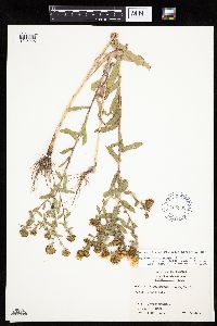 Grindelia squarrosa (Pursh) Dunal 605302[1045225]Demaree, Delzie 567801967-08-23 United States, Minnesota, Wilkin, Wilken [sic] County...P.O. Breckenridge;;132N;47W;00, 46.240081 -96.553133, 305m |
MIN:Plants | Grindelia squarrosa (Pursh) Dunal 478533[]Bright, R. 71-351971-00-00 United States, Idaho, Franklin, [no further data] |
MIN:Plants |  Grindelia squarrosa (Pursh) Dunal 906099[1045213]Anderson, M. 52008-09-24 United States, Minnesota, Ramsey, Ramsey Co, Sarita wetland fore-basin shoreline, between Como Ave and Commonwealth Ave, immediately west of the Intercampus Transitway, south of parking lot. T29N R23W.. 029N 23W 21, 44.9786111 -93.1813889 |
MIN:Plants |  Grindelia squarrosa (Pursh) Dunal 430709[1045239]Wheeler, Gerald 111291988-07-16 United States, Minnesota, Traverse, Traverse Co.; Browns Valley (NE side), W of Rte. 2; NW1/4 NW1/4 Sec. 34 T125N R49W (Folsom Township);;125N;49W;34, 45.593308 -96.813211 |
MIN:Plants |  Grindelia squarrosa (Pursh) Dunal 435017[1045198]Harris, Fred 941721994-08-10 United States, Minnesota, Olmsted, Olmsted County...Growing along side of gravel road access to gravel pit...SE1/4 of NW1/4 of SE1/4 Sect. 20 T108N R14W;;108N;14W;20, 44.144378 -92.528432 |
MIN:Plants |  Grindelia squarrosa (Pursh) Dunal 439488[1045246]Smith, Welby 163551989-09-05 United States, Minnesota, Mille Lacs, Mille Lacs Co.; at the railroad crossing in Onamia (Soo Line and CSAH 25). NW1/4 NE1/4 sec.6, T41N R26W;;041N;26W;6, 46.062223 -93.673225 |
MIN:Plants | 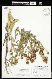 Grindelia squarrosa (Pursh) Dunal 439618[1045194]Smith, Welby 164401989-09-06 United States, Minnesota, Benton, Benton County...On the Platte River about 1.5 mi north of its confluence with the Mississippi River, and about 1.5 mi S of Royalton. SE1/4 NW1/4 sec.11, T38N R32W. 038N 32W 11, 45.8013889 -94.2916667 |
MIN:Plants | 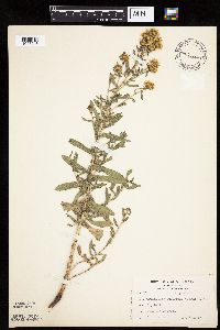 Grindelia squarrosa (Pursh) Dunal 439667[1045243]Kukachka, B. 2021937-07-19 United States, Minnesota, Ramsey, Ramsey Co.; Como and Doswell;;028N;23W;, 44.905162 -93.166462 |
MIN:Plants | 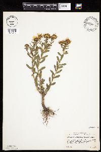 Grindelia squarrosa (Pursh) Dunal 453381[1045247]Abbott, Robinson s.n.1958-09-01 United States, Minnesota, Hennepin, Hennepin Co.; just N. of Camden section, Minneapolis, on Tyndale Ave, by Miss Ct.;;029N;24W;, 44.991926 -93.288153 |
MIN:Plants | 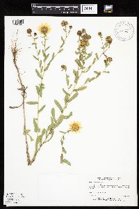 Grindelia squarrosa (Pursh) Dunal 515606[1045245]Estes, Carol LL9041993-08-18 United States, Minnesota, Cass, Cass Co.; Leech Lake Department of Resources Management compound near Cass Lake; T 145N R 31W NE1/4 SW1/4 Sec 16;Leech Lake Indian Reservation;145N;31W;16, 47.37382 -94.618473 |
MIN:Plants |  Grindelia squarrosa (Pursh) Dunal 518587[1045193]Darveaux, B. s.n.1991-07-23 United States, Minnesota, Scott, Shakopee, Scott Co. Minnesota Valley Wildlife Refuge. Rt. 101 N.;Minnesota Valley National Wildlife Refuge;115N;23W;00, 44.761567 -93.581604 |
MIN:Plants |  Grindelia squarrosa (Pursh) Dunal 812583[1045244]Wheeler, Gerald 123521988-09-25 United States, Minnesota, Big Stone, Ca. 4 mi SSW of Beardsley; W of unmarked county road. Near creek W of bluffs. N1/2 NW1/4 Sec 6 T123N R48W (Foster Twp).;;123N;48W;6, 45.49473 -96.73027 |
MIN:Plants |  Grindelia squarrosa (Pursh) Dunal 815852[1045241]Wheeler, Gerald 124251988-09-27 United States, Minnesota, Big Stone, Ca. 3.5 mi NNE of Ortonville; E of Rte 7. W1/2 sec 29 T122N R46W (Big Stone Twp);;122N;46W;29, 45.34761 -96.461599 |
MIN:Plants |  Grindelia squarrosa (Pursh) Dunal 831008[1045248]Cholewa, A. 21171993-08-20 United States, Minnesota, Ramsey, Ramsey Co. Shoreview, Rice Creek Watershed Open Space, Lexington Ave. at Co.Rd.J, T30N R23W Sec.3 NW1/4.;;030N;23W;3, 45.116139 -93.15785 |
MIN:Plants | 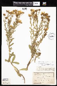 Grindelia hirsutula Hooker & Arnott 209278[1045190]Ballard, C. 25541900-08-00 United States, Minnesota, Kittson, St Vincent, Kittson Co.;;163N;51W;02, 48.970241 -97.226709 |
MIN:Plants | 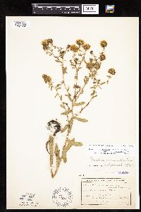 Grindelia hirsutula Hooker & Arnott 209279[1045184]Skinner, A.; et al. 88Sk1900-08-00 United States, Minnesota, Polk, Crookston;;150N;46W;30, 47.782001 -96.600066 |
MIN:Plants | 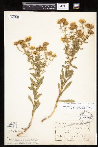 Grindelia hirsutula Hooker & Arnott 209282[1045183]Ballard, C. 25541900-08-00 United States, Minnesota, Kittson, St. Vincent;;163N;51W;02, 48.970241 -97.226709 |
MIN:Plants | 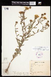 Grindelia hirsutula Hooker & Arnott 267231[1045186]Stevenson, J. 2861912-08-12 United States, Minnesota, Itasca, Grand Rapids.;;;;, 47.215547 -93.522987 |
MIN:Plants |  Grindelia hirsutula Hooker & Arnott 347122[1045185]Lakela, Olga 21871937-08-25 United States, Minnesota, Saint Louis, Superior bay near Duluth Ship Canal, Duluth.;;;;, 46.7308 -92.06217 |
MIN:Plants |  Grindelia hirsutula Hooker & Arnott 354812[1045179]Lakela, Olga 27721938-08-24 United States, Minnesota, Saint Louis, Oatka Beach Addition along Minnesota Ave, Duluth.;Minnesota Point;049N;13W;18, 46.740509 -92.059641 |
MIN:Plants |  Grindelia hirsutula Hooker & Arnott 360987[1045188]Lakela, Olga 39901940-08-11 United States, Minnesota, Saint Louis, near Interstate Bridge, 16th Ave, Rice Point, Duluth...St. Louis Co.;;;;, 46.76097 -92.10757 |
MIN:Plants |  Grindelia hirsutula Hooker & Arnott 386240[1045174]Lakela, Olga 58741944-09-07 United States, Minnesota, Saint Louis, 36th Ave E near London Road, Duluth.;;;;, 46.81853 -92.04861 |
MIN:Plants | 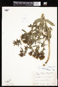 Grindelia hirsutula Hooker & Arnott 412842[1045182]Moore, John; Moore, Marjorie 114941939-08-07 United States, Minnesota, Kittson, Kittson County...Growing at the town of Noyes.;;164N;51W;25, 48.995724 -97.205109 |
MIN:Plants | 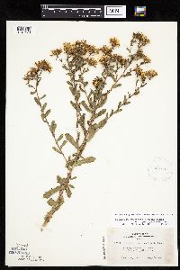 Grindelia hirsutula Hooker & Arnott 420710[1045176]Lakela, Olga 120571950-09-06 United States, Minnesota, Saint Louis, Highway terrace at Chisholm, St. Louis Co.;;;;, 47.489097 -92.883796 |
MIN:Plants |  Grindelia hirsutula Hooker & Arnott 442002[1045178]Moore, John; et al. 182371945-09-05 United States, Minnesota, Kittson, Kittson County...Along the rail road at Northcote.;;162N;49W;21, 48.840123 -97.007852 |
MIN:Plants | 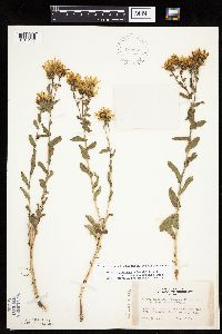 Grindelia hirsutula Hooker & Arnott 442569[1045177]Lakela, Olga 138591951-09-15 United States, Minnesota, Saint Louis, Sturgeon Lake Road north of Hibbing, St. Louis Co.;;;;, 47.659929 -93.01685 |
MIN:Plants | 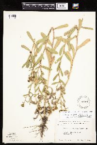 Grindelia hirsutula Hooker & Arnott 526266[1045187]Moore, John 211651951-08-06 United States, Minnesota, Clay, Kittson County...1 mi S of Barnsville.;;;;, 46.637705 -96.41979 |
MIN:Plants |  Grindelia hirsutula Hooker & Arnott 553954[1045181]Moore, John 226101955-07-26 United States, Minnesota, Clay, Clay County...4 mi S of Hitterdal.;;;;, 46.97167 -96.259228 |
MIN:Plants |  Grindelia hirsutula Hooker & Arnott 693921[1045173]Roefer, Florence s.n.1978-08-16 United States, Minnesota, Cottonwood, Cottonwood County...Jeffers Petroglyph Historic Site. T 107 N, R 35 W, NW 1/4 sec 9, Delton Twp.;Jeffers Petroglyphs Historical Site;107N;35W;09, 44.086452 -95.049966 |
MIN:Plants |  Grindelia hirsutula Hooker & Arnott 727812[1045175]Farrell, P.; et al. 2201979-08-01 United States, Minnesota, Polk, Pembina Trail Preserve Scientific Natural Area. Polk County...Pembina Trail Preserve...6.5 mi E of Harold, all sec. 36, frac. sec. 25, 30, 31, T149N R45W, frac. sec. 1, 2, T148N, R45W. , 47.702107 -96.357761 |
MIN:Plants |  Grindelia hirsutula Hooker & Arnott 747117[1045189]Galatowitsch, S. 6771982-08-20 United States, Minnesota, Wabasha, SE1/4 and E1/2 NE1/4 of sec 7; NW1/4 and W1/2 NE1/4 of Sec 8.;Kellogg-Weaver Dunes Scientific Natural Area / Kellogg-Weaver Dunes, The Nature Conservancy;109N;09W;, 44.233108 -91.917245 |
MIN:Plants |  Grindelia squarrosa (Pursh) Dunal 209269[1045231]Sheldon, Edmund S14331891-08-00 United States, Minnesota, Pipestone, Pipestone [assuming near town];;106N;46W;12, 44.001365 -96.317629 |
MIN:Plants |  Grindelia squarrosa (Pursh) Dunal 209270[1045227]Menzel, Max s.n.1894-08-00 United States, Minnesota, Pipestone, Pipestone [assuming the quarry area; town generally noted as Pipestone City by collector];Pipestone National Monument;106N;46W;01, 44.01585 -96.31767 |
MIN:Plants |  Grindelia squarrosa (Pursh) Dunal 209271[1045232]Sheldon, Edmund S26871892-07-00 United States, Minnesota, Crow Wing, Brainerd.;;133N;28W;03, 46.368709 -94.200714 |
MIN:Plants |  Grindelia squarrosa (Pursh) Dunal 209272[1285955]Leiberg, John s.n. United States, Minnesota, Rock, Rock Co.;;;;, 43.67 -96.25 |
MIN:Plants |  Grindelia squarrosa (Pursh) Dunal 209274[1045229]Burglehaus, F. s.n.1891-08-00 United States, Minnesota, Crow Wing, Brainerd;;133N;28W;03, 46.368709 -94.200714 |
MIN:Plants |  Grindelia squarrosa (Pursh) Dunal 209275[1285956]Leiberg, John s.n. United States, Minnesota, Rock, Rock Co.;;;;, 43.67 -96.25 |
MIN:Plants |  Grindelia squarrosa (Pursh) Dunal 209276[1045228]Sandberg, John s.n.1891-08-00 United States, Minnesota, Crow Wing, Brainerd.;;133N;28W;03, 46.368709 -94.200714 |
MIN:Plants |  Grindelia squarrosa (Pursh) Dunal 209281[1045230]Menzel, Max 54651895-08-00 United States, Minnesota, Pipestone, Pipestone [assuming the quarry area; town generally noted as Pipestone City by collector];Pipestone National Monument;106N;46W;01, 44.015848 -96.317669 |
MIN:Plants |  Grindelia squarrosa (Pursh) Dunal 209283[1045236]Sheldon, Edmund s.n.1891-08-00 United States, Minnesota, Pipestone, Pipestone [assuming near town];;106N;46W;12, 44.001365 -96.317629 |
MIN:Plants |  Grindelia squarrosa (Pursh) Dunal 209284[1045237]Menzel, Max s.n1895-07-00 United States, Minnesota, Pipestone, Pipestone [assuming the quarry area; town generally noted as Pipestone City by collector];Pipestone National Monument;106N;46W;01, 44.015848 -96.317669 |
MIN:Plants |  Grindelia squarrosa (Pursh) Dunal 278454[1045238]Moyle, J. s.n.1931-11-02 United States, Minnesota, Hennepin, River flat on U. of Minn. Campus, Mpls.;;029N;24W;25, 44.969959 -93.237021 |
MIN:Plants |  Grindelia squarrosa (Pursh) Dunal 345932[1045226]Eneboe, H. 1061937-07-14 United States, Minnesota, Ramsey, Midway district, St. Paul;;029N;23W;00, 44.992077 -93.166387 |
MIN:Plants |  Grindelia squarrosa (Pursh) Dunal 554356[1045234]Moore, John 229911956-09-12 United States, Minnesota, Clay, Along the rail road 1/4 mi E of Moorhead.;;;;, 46.873852 -96.767581 |
MIN:Plants |  Grindelia squarrosa (Pursh) Dunal 554562[1045233]Moore, John 229431956-09-11 United States, Minnesota, Pipestone, Pipestone County...Pasture east of rail road, Pipestone National Monument, Pipestone;Pipestone National Monument;106N;46W;01, 44.015848 -96.317669 |
MIN:Plants |  Grindelia squarrosa (Pursh) Dunal 753569[1045235]Duxbury, Alexis 22271983-08-15 United States, Minnesota, Lincoln, Lincoln County...Hole-in-the-Mountain Prairie: T109N R45W [portions of] sec 19 & 20.;Hole-in-the-Mountain Prairie, The Nature Conservancy;109N;45W;19, 44.233753 -96.312179 |
MIN:Plants |  Grindelia squarrosa (Pursh) Dunal 815153[1045249]Wheeler, Gerald 124511988-09-27 United States, Minnesota, Big Stone, Big Stone County...Ca. 3.5 mi SW of Beardsley. On moranic hill overlooking Big Stone Lake. NW1/4 Sec 36 T124N R49W;;124N;49W;36, 45.510114 -96.749262 |
MIN:Plants |  Grindelia squarrosa (Pursh) Dunal 815180[1045240]Wheeler, Gerald 120371988-09-03 United States, Minnesota, Wilkin, Wilkin County...Ca. 8.5 mi SW of Campbell; N of Rt. 55. Bordering the Bois de Sioux River. S1/2 Sec 22 T130N R47W;;130N;47W;22, 46.056271 -96.558376 |
MIN:Plants |  Grindelia squarrosa (Pursh) Dunal 209267[1285958]Sandberg, John s.n.1890-08-00 United States, Minnesota, Hennepin, [no further data];;;;, 44.974747 -93.491973 |
MIN:Plants |  Grindelia squarrosa (Pursh) Dunal 209268[1045205]Anderson, A. An9501894-08-00 United States, Minnesota, Hennepin, Minneapolis;;029N;24W;25, 44.969959 -93.237021 |
MIN:Plants |  Grindelia squarrosa (Pursh) Dunal 209273[1045219]Moyer, Lycurgus s.n1897-09-11 United States, Minnesota, Chippewa, Montevideo;;117N;40W;18, 44.941761 -95.726666 |
MIN:Plants |  Grindelia squarrosa (Pursh) Dunal 209277[1045215]Aiton, G. s.n.1891-08-00 United States, Minnesota, Hennepin, Near Minneapolis.;;029N;24W;25, 44.969959 -93.237021 |
MIN:Plants |  Grindelia squarrosa (Pursh) Dunal 209280[1045220]Ballard, C. 27301900-08-00 United States, Minnesota, Kittson, Kennedy;;160N;49W;31, 48.638548 -97.030741 |
MIN:Plants |  Grindelia squarrosa (Pursh) Dunal 209285[1045200]Ballard, C. 27001900-08-00 United States, Minnesota, Kittson, Northcote;;162N;49W;21, 48.840123 -97.007852 |
MIN:Plants |  Grindelia squarrosa (Pursh) Dunal 241230[1045214]Van Wert, M. 1907-08-00 United States, Minnesota, Ramsey, Merr. Pk. [Merriam Park, St. Paul neighborhood at west end of Minnehaha Ave.];;029N;23W;00, 44.992077 -93.166387 |
MIN:Plants |  Grindelia squarrosa (Pursh) Dunal 367190[1045222]Koelnau, L. 671938-07-28 United States, Minnesota, Hennepin, 54th St. & 30th Ave. So, Minneapolis;;;;, 44.90533 -93.22983 |
MIN:Plants |  Grindelia squarrosa (Pursh) Dunal 550061[1045209]Moore, John; et al. 221741954-09-20 United States, Minnesota, Lyon, Lyon County...3 mi E of Balaton.;;109N;41W;19, 44.232349 -95.825767 |
MIN:Plants |  Grindelia squarrosa (Pursh) Dunal 553890[1045207]Moore, John 225751955-07-15 United States, Minnesota, Pipestone, At the Pipestone National Monument, E of the Headquarters.;Pipestone National Monument;106N;46W;012, 44.001365 -96.317629 |
MIN:Plants |  Grindelia squarrosa (Pursh) Dunal 564487[1045199]Rhone, R. s.n.1940-07-23 United States, Minnesota, Itasca, Deer River;;;;, 47.334197 -93.787874 |
MIN:Plants |  Grindelia squarrosa (Pursh) Dunal 566202[1045221]Moore, John; Bernardini, J. 242311958-09-17 United States, Minnesota, Blue Earth, Bluff 3 mi W of Mankato.;;;;, 44.152457 -94.068583 |
MIN:Plants |  Grindelia squarrosa (Pursh) Dunal 602140[1045216]Westkaemper, Remberta s.n.1965-08-00 United States, Minnesota, Stearns, Stearns County...St. Cloud;;;;, 45.541667 -94.205126 |
MIN:Plants |  Grindelia squarrosa (Pursh) Dunal 607569[1045217]Westkaemper, Remberta s.n.1966-08-00 United States, Minnesota, Stearns, Stearns County...St. Cloud;;;;, 45.541667 -94.205126 |
MIN:Plants |  Grindelia squarrosa (Pursh) Dunal 618793[1045204]Monserud, W. 1701949-08-08 United States, Minnesota, Hennepin, 5255 Dupont Ave N, Minneapolis;;;;, 45.05078 -93.29443 |
MIN:Plants |  Grindelia squarrosa (Pursh) Dunal 635025[1045218]Lindayen, T. 1901972-09-02 United States, Minnesota, Washington, Washington County...T 27N, R 21W, SW1/5 of Sec.26. 1 mi due S of Hwy 61 from jnc. of Co.Rd.19 & Hwy.61. About 100 ft from the road.. 027N 21W 26, 44.797346 -92.893437 |
MIN:Plants |  Grindelia squarrosa (Pursh) Dunal 687881[1045206]Wheeler, Gerald; Glaser, Paul 23281977-07-29 United States, Minnesota, Itasca, Itasca County...Approx. 10 mi W of Grand Rapids. At edge of Mississippi River public access parking area. SW1/4 SW1/4 sec 22 T55N R27W.. 055N 27W 22, 47.232597 -93.755926 |
MIN:Plants |  Grindelia squarrosa (Pursh) Dunal 709846[1045201]Wheeler, Gerald 48611979-08-08 United States, Minnesota, Dakota, Dakota County...Approx. 0.5 mi NW of Nicols. Along the railroad tracks. T27N R23W sec 18;Fort Snelling State Park;027N;23W;18, 44.825884 -93.216999 |
MIN:Plants |  Grindelia squarrosa (Pursh) Dunal 710028[1045210]Wheeler, Gerald 50581979-10-06 United States, Minnesota, Le Sueur, East Minnesota River Wildlife Management Area. Le Sueur County...Approx. 1 mi SW of Kasota. On a dry bluff overlooking the Minnesota River. High Lime Prairie. T109N R26W sec 6.. 109N 26W 6, 44.274575 -93.998474 |
MIN:Plants |  Grindelia squarrosa (Pursh) Dunal 711685[1045203]Smith, Welby 17621979-08-30 United States, Minnesota, Goodhue, Goodhue County...T114N R16W; SW1/4 sec.15. 3/8 mi NW of where east-west co.18 crosses tracks of the St Paul & Pacific R.R.. 114N 16W 15, 44.67995 -92.722544 |
MIN:Plants |  Grindelia squarrosa (Pursh) Dunal 711699[1045202]Smith, Welby 17761979-09-08 United States, Minnesota, Dakota, Dakota County...T27N R23W; NE1/4 sec.18. 1/2 mi NE of State Hwy 36, within the municipal boundaries of Eagan. Chicago and Northwestern Railroad track.. 027N 23W 18, 44.825884 -93.216999 |
MIN:Plants |  Grindelia squarrosa (Pursh) Dunal 728231[1045242]Severson, M.; et al. 3141979-08-28 United States, Minnesota, Polk, Pembina Trail Preserve Scientific Natural Area. Polk County...Pembina Trail Preserve...6-1/2 mi E of Harold, all sec. 36, frac. sec. 25, 30, 31, T149N R45W, frac. sec. 1, 2, T148N, R45W. , 47.702107 -96.357761 |
MIN:Plants |  Grindelia squarrosa (Pursh) Dunal 741309[1045208]Converse, C. 20981982-08-24 United States, Minnesota, Otter Tail, Otter Tail County...NE1/4 NE1/4 Sec.17. Otter Tail Preserve: T131N R44W;Ottertail Prairie Scientific Natural Area;131N;44W;17, 46.159244 -96.235363 |
MIN:Plants |  Grindelia squarrosa (Pursh) Dunal 745843[1045196]Smith, Welby 57151981-09-05 United States, Minnesota, Wright, Wright County ... on the SW side of State Hwy 55, about 1/4 mi NW of its jnc. with State Hwy 25 in Buffalo. NE1/4 SW1/4 sec 9 T120N R25W.. 120N 25W 9, 45.215868 -93.837322 |
MIN:Plants | Grindelia hirsutula Hooker & Arnott 209218[]Moyer, Lycurgus 7061915-08-18 United States, North Dakota, Slope, Bad Lands, Marmarth |
MIN:Plants |  Grindelia squarrosa (Pursh) Dunal 470899[1285954]Wheeler, Gerald 204891999-09-09 United States, Minnesota, McLeod, McLeod County ... Ca. 2 mi. SW of Glencoe; Isaac Walton Game Refuge; where unmarked county road crosses RR tracks ... W1/2 NW1/4 NE1/4 Sec. 21 T115N R28W (Glancoe 21). 115N 28W 21, 44.754256 -94.202747 |
MIN:Plants |  Grindelia squarrosa (Pursh) Dunal 489878[1285962]Stevens, O. s.n.1936-08-26 United States, North Dakota, Cass, Fargo. |
MIN:Plants |  Grindelia squarrosa (Pursh) Dunal 435962[1127517]Wheeler, Gerald 172571997-08-15 United States, Minnesota, Yellow Medicine, Yellow Medicine County...Ca. 7 mi. N of Echo on Rte. 67, 0.2 mi. E on Rte. A1; NE1/4 NW1/4 SW1/4 Sec. 34 T115N R38W (Sioux Agency 34 'N'). 115N 38W 34, 44.723065 -95.411758 |
MIN:Plants | Grindelia hirsutula Hooker & Arnott 209169[]Elmer, A.D.E. 46211903-07-00 United States, California, Marin, Point Reyes. County: Marin;Point Reyes National Seashore |
MIN:Plants |  Grindelia squarrosa (Pursh) Dunal 268868[1285961]Moore, John W. 16271924-08-00 United States, South Dakota, Brookings, 44.284135 -96.685606 |
MIN:Plants | Grindelia hirsutula Hooker & Arnott 776206[]Cooper, William 761925-07-23 United States, California, Marin, Marin County ... Point Reyes;Point Reyes National Seashore |
MIN:Plants |  Grindelia squarrosa (Pursh) Dunal 794892[1285960]Schaaf, J. 1011982-10-26 United States, Nevada, Lander, Lander Co. ... SR 305 MP 32 ... north of Austin, 1838m |
MIN:Plants |  Grindelia squarrosa (Pursh) Dunal 922596[1285957]Smith, Welby 234331993-08-10 United States, Minnesota, Brown, Cottonwood River Prairie Scientific Natural Area. Cottonwood River Prairie State Scientific and Natural Area, about 5 miles south of Springfield... T 109N R35W NW1/4 of SW1/4 of Sec 33. 109N 35W 35, 44.2005556 -95.0647222 |
MIN:Plants |  Grindelia squarrosa (Pursh) Dunal 922599[1285959]Smith, Welby 233171993-08-03 United States, Minnesota, Renville, About 4 miles east of Sacred Heart. SE1/4 of SE1/4 of Sec.;;115N;37W;02, 44.7913889 -95.2602778 |
MIN:Plants |  Grindelia squarrosa (Pursh) Dunal 931192[1285953]Smith, Welby R. 161931989-08-23 United States, Minnesota, Nobles, About 10 miles NW of Worthington. NW1/4 of NW1/4 of section;Groth Wildlife Management Area;103N;41W;02, 43.754218 -95.722931 |
MIN:Plants |  Grindelia squarrosa (Pursh) Dunal 447800[1285952]Pomroy, Deborah DLP28192013-07-31 United States, Minnesota, Saint Louis, Duluth. Univ. of Minn. Duluth property, Limnology Lab station. Lake Superior. UTM: 5187204N, 575685E. NE1/4 of NE1/4 of section;;050N;13W;08, 46.8361111 -92.0075 |
MIN:Plants |  249074[1000007]Lunell, J. 1040-11908-09-08 United States, North Dakota, Benson, Leeds |
MIN:Plants |  Grindelia aphanactis Rydberg 209287[1001241]Baker, C.F. 5261898-07-21 United States, Colorado, La Plata, Durango |
MIN:Plants |  Grindelia arizonica var. dentata Steyermark 209236[1001242]Metcalfe, O.E. 7441903-09-19 United States, New Mexico, Grant, Bear Mountain, near Silver City, 2438m |
MIN:Plants |  Grindelia brownii Heller 209161[1001243]Heller, A.A. 34181896-07-14 United States, Idaho, Washington, Vicinity of Forest, 1067m |
MIN:Plants |  Grindelia glandulosa Greenman 209176[1001244]Pringle, C.G. 69621898-08-13 Mexico, Hidalgo, Sierra de Pachuca |
Google Map
Google Maps is a web mapping service provided by Google that features a map that users can pan (by dragging the mouse) and zoom (by using the mouse wheel). Collection points are displayed as colored markers that when clicked on, displays the full information for that collection. When multiple species are queried (separated by semi-colons), different colored markers denote each individual species.