University of Minnesota
http://www.umn.edu/
612-625-5000
http://www.umn.edu/
612-625-5000
Minnesota Biodiversity Atlas
Bell Museum
Dataset: MIN-Plants
Taxa: Heliopsis
Search Criteria: excluding cultivated/captive occurrences
Bell Museum plants | |
 MIN:Plants | 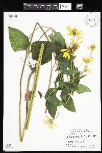 Heliopsis helianthoides (L.) Sweet 906930[1046474]Smith, Welby 311762008-08-19 United States, Minnesota, Beltrami, Along gravel road that runs on the north side of Upper Red Lake, about 4 miles west of its junction with Highway 72. SW1/4 of SW1/4 of section;Red Lake Wildlife Management Area;155N;31W;21, 48.225 -94.6361111 |
MIN:Plants | 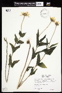 Heliopsis helianthoides var. scabra (Dunal) Fernald 461927[1046592]Wheeler, Gerald 169451977-08-07 United States, Minnesota, Swift, Swift County ... Ca. 9 mi. N of Murdock on Rte. 33, W of road ... NE1/4 NW1/4 Sec. 30 T122N R37W (Kerkhoven 30);;122N;37W;30, 45.347311 -95.368095 |
MIN:Plants | 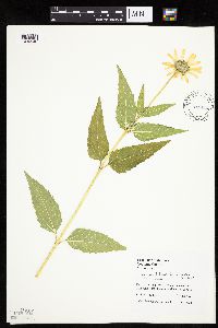 Heliopsis helianthoides var. scabra (Dunal) Fernald 493617[1046540]Juhnke, C. 141 CMJ FRO1998-10-14 United States, Minnesota, Goodhue, Frontenac State Park. Goodhue County ... Next to trail and Cty. Rd. 2 ... T 112N R 13W SW SE NW 11;Frontenac State Park;112N;13W;11, 44.51999 -92.339224 |
MIN:Plants | 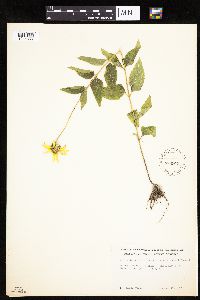 Heliopsis helianthoides var. scabra (Dunal) Fernald 539973[1046565]Tester, John s.n.1957-08-13 United States, Minnesota, Mahnomen, 3-4 miles w. and 1 mile s. of Waubun.;Waubun Prairie Wildlife Management Area / White Earth Indian Reservation;143N;42W;33, 47.158904 -96.00743 |
MIN:Plants | 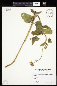 Heliopsis helianthoides var. scabra (Dunal) Fernald 479495[1046550]Wheeler, Gerald 192351998-06-16 United States, Minnesota, Le Sueur, Le Sueur Co.; Ca. 2.7 mi. SW of Kasota, SW of Kasota Prairie SNA; W1/2 SW1/4 SW1/4 Sec. 7 T109N R26W (Kasota 7);East Minnesota River Wildlife Management Area;109N;26W;7, 44.261227 -93.999334 |
MIN:Plants | 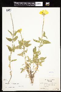 Heliopsis parvifolia A. Gray 283562[1046638]Moore, J.; et al. 32131931-06-22 United States, Texas, Brewster, Chisos Mountains. Brewster County ... north of Emory Peak;Big Bend National Park, 2300m |
MIN:Plants | 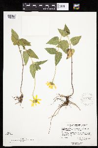 Heliopsis helianthoides var. scabra (Dunal) Fernald 575693[1046633]Garton, C. 93411961-08-10 Canada, Ontario, Rainy River, Rainy River District...up from Rainy R. at Long Sault Rapids, Birchdale Landing, Roseberry Twp. |
MIN:Plants | 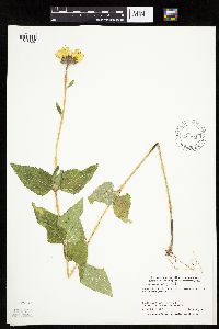 Heliopsis helianthoides var. scabra (Dunal) Fernald 436898[1046607]Smith, Welby 267751997-08-12 United States, Minnesota, Koochiching, Koochiching County ... Voyageurs National Park ... (Tom Cod Creek) ... T69N R22W SE1/4 of SW1/4 of Sec 11;Voyageurs National Park;069N;22W;11, 48.4747238 -93.1244431 |
MIN:Plants |  210456[1286149]Steele, E.; et al. 491901-08-23 United States, Virginia, Page, Stony Man Mountain and vicinity in the Blue Ridge, near Luray [Shenandoah National Park], 1097m |
MIN:Plants |  Heliopsis helianthoides var. scabra (Dunal) Fernald 294821[1046635]Benner, F.; Benner, J. 4431928-08-25 United States, Wisconsin, Polk, 7 mi N. St. Croix Falls, Wis. on River Road;Saint Croix National Riverway;;;, 45.481172 -92.687024 |
MIN:Plants |  Heliopsis helianthoides var. scabra (Dunal) Fernald 524766[1046636]Benner, F.; Benner, J. 41928-07-08 United States, Wisconsin, Polk, 7 mi N. St. Croix Falls, Wis. on River Road near Spring;Saint Croix National Riverway;;;, 45.481172 -92.687024 |
MIN:Plants |  Heliopsis helianthoides var. scabra (Dunal) Fernald 479993[1046608]Wheeler, Gerald 189761998-06-09 United States, Minnesota, Carver, Carver Co.; Ca. 2.5 mi. E of East Union on Rte. 50, S of road; E1/2 NE1/4 Sec. 6 T114N R23W;;114N;23W;6, 44.710544 -93.63374 |
MIN:Plants | 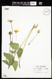 Heliopsis helianthoides var. scabra (Dunal) Fernald 911544[1046564]Smith, Welby 217541992-08-27 United States, Minnesota, Brown, Tauer Prairie Scientific Natural Area. Brown County...Tauer Prairie State Scientific and Natural Area, about 7 miles south-southwest of New Ulm...T 109N R 31W NW1/4 of SW1/4 of Sec 35. 109N 31W 35, 44.2013889 -94.5302778 |
MIN:Plants | 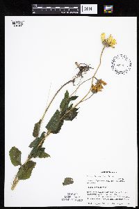 Heliopsis helianthoides var. scabra (Dunal) Fernald 438188[1046486]Cully, Anne; et al. s.n.1998-08-10 United States, Minnesota, Pipestone, Pipestone County, Pipestone National Monument UTM 0714399N 4876297E;Pipestone National Monument;106N;46W;01, 44.015848 -96.317669 |
MIN:Plants | 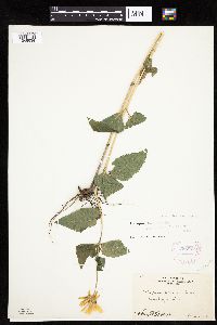 Heliopsis helianthoides var. scabra (Dunal) Fernald 268872[1046634]Moore, John 16301922-06-00 United States, South Dakota, Brookings, Brookings;;;;, 44.31139 -96.79806 |
MIN:Plants | 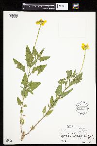 Heliopsis parvifolia A. Gray 602069[1046637]Hess, W. 8071966-08-11 United States, Texas, Brewster, Brewster Co. ... Big Bend Natn'l Park, from The Basin on western trail to Laguna Meadows.;Big Bend National Park, 1981m |
MIN:Plants | 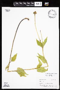 Heliopsis helianthoides (L.) Sweet 439298[1045814]Mason, Harriet; Mason, Charles NSP98-731998-07-20 United States, Minnesota, Rice, North of snowmobile entrance near bat house. SW corner of section;Nerstrand Woods State Park;110N;19W;16, 44.334371 -93.111203 |
MIN:Plants | 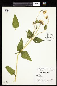 Heliopsis helianthoides var. scabra (Dunal) Fernald 444395[1046619]Nation, R. 94-2271994-07-05 United States, Minnesota, Mower, Lake Louise State Park. Mower County...Tract 6. T101N R14W SW1/4 of NE1/4 of sec. 29;Lake Louise State Park;101N;14W;29, 43.522073 -92.538883 |
MIN:Plants | 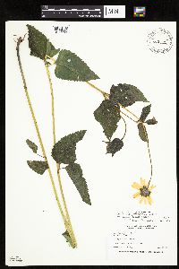 Heliopsis helianthoides var. scabra (Dunal) Fernald 445626[1046618]Nation, R. 94-1631994-06-21 United States, Minnesota, Mower, Lake Louise State Park. Mower County...Tract #22B. T101N R14W N1/2 NE1/4 of sec. 21;Lake Louise State Park;101N;14W;21, 43.536578 -92.519043 |
MIN:Plants | 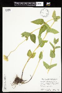 Heliopsis helianthoides (L.) Sweet 440418[1046438]Smith, Welby 143901988-06-30 United States, Minnesota, Nobles, Nobles Co. About 2mi SW of Worthington; on the right-of-way of the C&NW Railroad; SW1/4 SE1/4 sec.32, T102N R40W;;102N;40W;32, 43.5877762 -95.6616669 |
MIN:Plants | 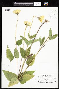 Heliopsis helianthoides (L.) Sweet 520308[1046429]Smith, Welby 212741992-08-10 United States, Minnesota, Wadena, Wadena Co.; between Trunk Highway 10 and the Burlington Northern Railroad tracks, on the E side of Wadena (town); Wadena Co.; between Trunk Highway 10 and the Burlington Northern Railroad tracks, on the E side of Wadena (town); T134N R35W NE1/4 of NW1/4 of Sec 8. 134N 35W 8, 46.4388885 -95.1263885 |
MIN:Plants | 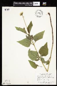 Heliopsis helianthoides (L.) Sweet 745548[1046546]Smith, Welby 44011981-06-24 United States, Minnesota, Mower, Wild Indigo Scientific Natural Area. Wild Indigo Scientific and Natural Area. About 4 mi SW of the jnc. of State Hwy.56 and Co. Hwy.2 in Brownsdale. NE1/4 NW Wild Indigo Scientific and Natural Area. About 4 mi SW of the jnc. of State Hwy.56 and Co. Hwy.2 in Brownsdale. NE1/4 NW1/4 sec.24, T103N R18W. 103N 18W 24, 43.710437 -92.939849 |
MIN:Plants | 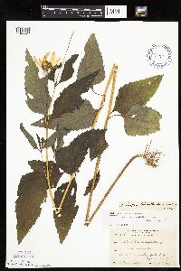 Heliopsis helianthoides var. scabra (Dunal) Fernald 209896[1046627]Rosendahl, C. 38781919-08-09 United States, Minnesota, Fillmore, Root River Valley. Holt Twp.;;103N;09W;, 43.716976 -91.909804 |
MIN:Plants | 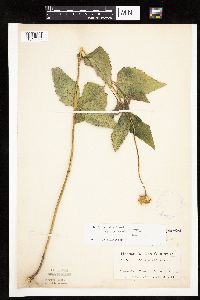 Heliopsis helianthoides var. scabra (Dunal) Fernald 209898[1046588]Ainslie, G. 39131902-06-17 United States, Minnesota, Olmsted, Rochester;;106N;14W;, 43.97834 -92.49834 |
MIN:Plants | 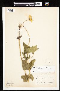 Heliopsis helianthoides var. scabra (Dunal) Fernald 209931[1046589]Ainslie, G. 39101902-06-19 United States, Minnesota, Olmsted, Rochester;;106N;14W;, 43.97834 -92.49834 |
MIN:Plants | 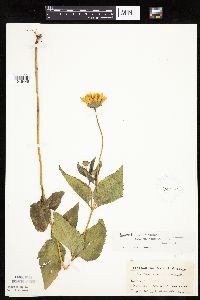 Heliopsis helianthoides var. scabra (Dunal) Fernald 210315[1046448]Ainslie, G. 39141902-06-17 United States, Minnesota, Olmsted, Oronoco;;108N;14W;, 44.151378 -92.498389 |
MIN:Plants | 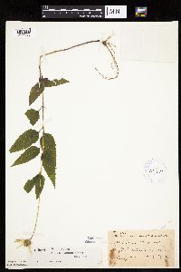 Heliopsis helianthoides var. scabra (Dunal) Fernald 210475[1046630]Taylor, B. T16431892-08-00 United States, Minnesota, Chisago, Lindstrom;;N;;, 45.389408 -92.847992 |
MIN:Plants | 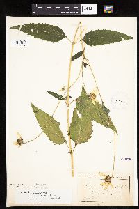 Heliopsis helianthoides var. scabra (Dunal) Fernald 210476[1046490]Wheeler, William 6141899-08-25 United States, Minnesota, Houston, Brownsville;;103N;04W;, 43.695398 -91.283479 |
MIN:Plants | 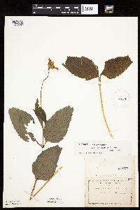 Heliopsis helianthoides var. scabra (Dunal) Fernald 210477[1046556]Manning, Sara s.n. United States, Minnesota, Wabasha, Lake City;;111N;12W;04, 44.447017 -92.258983 |
MIN:Plants | 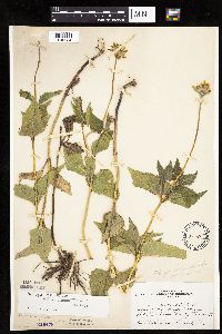 Heliopsis helianthoides var. scabra (Dunal) Fernald 210478[1046534]Skinner, S. 991902-06-13 United States, Minnesota, Jackson, W of Mr. Wood's, Heron Lake;;N;;, 43.794404 -95.322499 |
MIN:Plants | 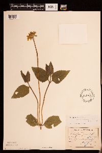 Heliopsis helianthoides var. occidentalis (T.R. Fischer) Steyerm. 210479[1286141]Aiton, George B. s.n. United States, Minnesota, Rice, [no further data], 44.359018 -93.310986 |
MIN:Plants | 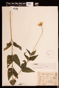 Heliopsis helianthoides var. scabra (Dunal) Fernald 210481[1286144]Aiton, George B. s.n.1889-07-24 United States, Minnesota, Hennepin, [no further data], 45 -93.47 |
MIN:Plants | 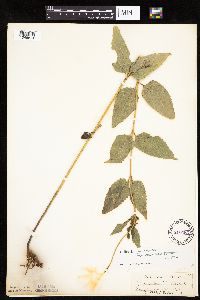 Heliopsis helianthoides var. scabra (Dunal) Fernald 210483[1046614]Sandberg, John 38791884-07-00 United States, Minnesota, Goodhue, Red Wing;;N;;, 44.555216 -92.495543 |
MIN:Plants | 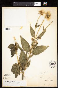 Heliopsis helianthoides var. scabra (Dunal) Fernald 210484[1046437]Manning, Sara s.n.1885-08-25 United States, Minnesota, Wabasha, Lake City;;111N;12W;04, 44.447017 -92.258983 |
MIN:Plants | 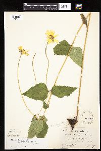 Heliopsis helianthoides var. scabra (Dunal) Fernald 210485[1046472]Rosendahl, C.; Butters, F. s.n.1919-06-27 United States, Minnesota, Hennepin, Bush Lake region;;N;;, 44.836723 -93.382796 |
MIN:Plants | 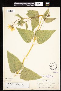 Heliopsis helianthoides var. scabra (Dunal) Fernald 210486[1046481]Rosendahl, C. 5271902-06-16 United States, Minnesota, Houston, Spring Grove;;101N;07W;, 43.543923 -91.6707 |
MIN:Plants | 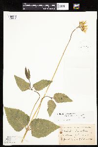 Heliopsis helianthoides var. scabra (Dunal) Fernald 210487[1046524]Herrick, C. s.n.1878-06-00 United States, Minnesota, Hennepin, Minneapolis;;N;;, 44.979965 -93.263836 |
MIN:Plants | 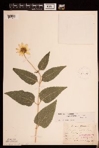 Heliopsis helianthoides var. scabra (Dunal) Fernald 210489[1286142]Sandberg, J. H. s.n.1886-07-00 United States, Minnesota, Goodhue, [no further data], 44.40976099 -92.72282341 |
MIN:Plants | 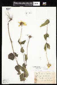 Heliopsis helianthoides var. scabra (Dunal) Fernald 210490[1046483]Sheldon, Edmund S15901891-08-00 United States, Minnesota, Lincoln, Lake Benton;;109N;45W;, 44.24108 -96.26172 |
MIN:Plants | 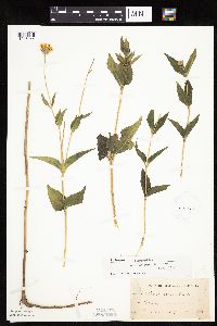 Heliopsis helianthoides var. scabra (Dunal) Fernald 210491[1046444]Oestlund, O. s.n.1886-00-00 United States, Minnesota, Hennepin, Minneapolis;;N;;, 44.979965 -93.263836 |
MIN:Plants | 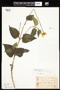 Heliopsis helianthoides var. scabra (Dunal) Fernald 210492[1046587]Taylor, B. T4761891-06-00 United States, Minnesota, Waseca, [Illegible] Lake;;N;;, 44.02 -93.59 |
MIN:Plants | 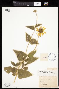 Heliopsis helianthoides var. scabra (Dunal) Fernald 210493[1046625]G. & L. 38791885-07-08 United States, Minnesota, Chippewa, Montevideo;;117N;40W;, 44.934626 -95.675774 |
MIN:Plants | 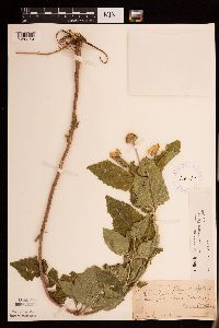 Heliopsis helianthoides var. occidentalis (T.R. Fischer) Steyerm. 210494[1286140]Huntington, A. s.n.1890-07-05 United States, Minnesota, Rock, [no further data], 43.67 -96.25 |
MIN:Plants | 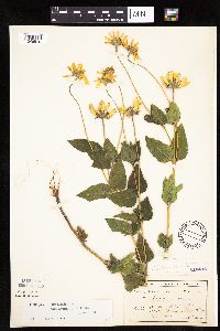 Heliopsis helianthoides var. scabra (Dunal) Fernald 210495[1046510]MacMillan, C.; et al. 204Sk1900-08-00 United States, Minnesota, Polk, Crookston;;150N;46W;30, 47.782 -96.60007 |
MIN:Plants | 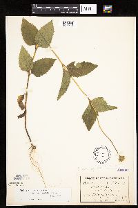 Heliopsis helianthoides var. scabra (Dunal) Fernald 210496[1046631]MacMillan, C.; et al. 117Sk1900-08-00 United States, Minnesota, Polk, Maple Lake;;148N;43W;, 47.629357 -96.131143 |
MIN:Plants | 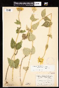 Heliopsis helianthoides var. scabra (Dunal) Fernald 210497[1046557]Menzel, Max s.n.1895-07-00 United States, Minnesota, Pipestone, Pipestone [assuming the quarry area; town generally noted as Pipestone City by collector];Pipestone National Monument;106N;46W;01, 44.015848 -96.317669 |
MIN:Plants | 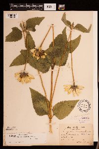 Heliopsis helianthoides var. scabra (Dunal) Fernald 210498[1286138]Sandberg, J. H. s.n.1886-08-00 United States, Minnesota, Hennepin, [no further data], 45 -93.47 |
MIN:Plants | 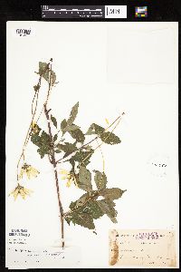 Heliopsis helianthoides var. scabra (Dunal) Fernald 210499[1046477]Holzinger, John; Arthur, J. 861886-09-00 United States, Minnesota, Winona, Winona;;N;;, 44.049963 -91.639315 |
MIN:Plants | 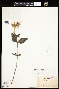 Heliopsis helianthoides var. scabra (Dunal) Fernald 210500[1046500]Holzinger, John s.n.1889-09-14 United States, Minnesota, Winona, Winona;;N;;, 44.049963 -91.639315 |
MIN:Plants | 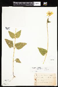 Heliopsis helianthoides var. scabra (Dunal) Fernald 210501[1046446]Kassube, J. s.n.1878-06-00 United States, Minnesota, Hennepin, Minneapolis;;N;;, 44.979965 -93.263836 |
MIN:Plants | 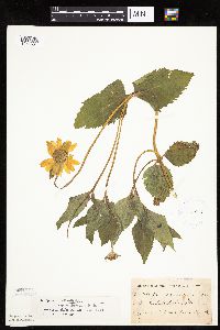 Heliopsis helianthoides var. scabra (Dunal) Fernald 210502[1046501]Ballard, C. B9631892-06-00 United States, Minnesota, Middle Lake;;;;, 45.310153 -95.075633 |
MIN:Plants | 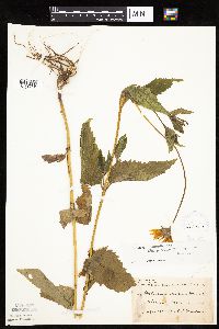 Heliopsis helianthoides var. scabra (Dunal) Fernald 210503[1046504]Sheldon, Edmund S27571892-07-00 United States, Minnesota, Mille Lacs, Milaca;;N;;, 45.755799 -93.654408 |
MIN:Plants | 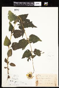 Heliopsis helianthoides var. scabra (Dunal) Fernald 210504[1046623]Taylor, B. T7791891-07-00 United States, Minnesota, Pope, Glenwood;;N;;, 45.650239 -95.389758 |
MIN:Plants | 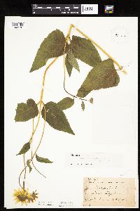 Heliopsis helianthoides var. scabra (Dunal) Fernald 210505[1046578]Taylor, B. 13481892-07-00 United States, Minnesota, Chisago, Center City;;034N;20W;34, 45.389763 -92.825913 |
MIN:Plants | 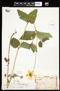 Heliopsis helianthoides var. scabra (Dunal) Fernald 210506[1046493]Ballard, C. B15761893-07-00 United States, Minnesota, Cass, Upper Gull Lake;;N;;, 46.446379 -94.35099 |
MIN:Plants | 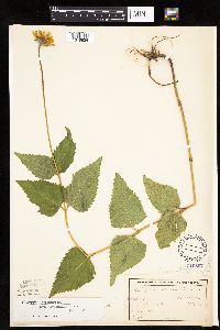 Heliopsis helianthoides var. scabra (Dunal) Fernald 210507[1046624]Frost, W. F.2071892-07-00 United States, Minnesota, Kandiyohi, Willmar;;N;;, 45.110139 -95.062995 |
MIN:Plants | 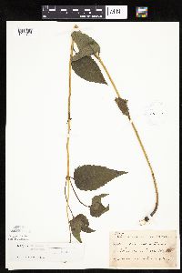 Heliopsis helianthoides var. scabra (Dunal) Fernald 210508[1046496]Taylor, B. T5891891-06-00 United States, Minnesota, Faribault, Minnesota Lake;;N;;, 43.804422 -93.827689 |
MIN:Plants | 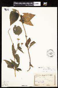 Heliopsis helianthoides var. scabra (Dunal) Fernald 210509[1046457]Sheldon, Edmund s.n.1892-07-00 United States, Minnesota, Kanabec, Mora, Kanabec Co.;;039N;24W;, 45.860683 -93.327529 |
MIN:Plants | 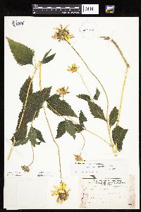 Heliopsis helianthoides var. scabra (Dunal) Fernald 210510[1046445]Frost, W. s.n.1892-08-00 United States, Minnesota, Kandiyohi, Spicer;;N;;, 45.196059 -94.940381 |
MIN:Plants | 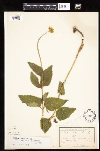 Heliopsis helianthoides var. scabra (Dunal) Fernald 210511[1046529]Frost, W. F1771892-06-00 United States, Minnesota, Meeker, Acton [pioneer village];;119N;32W;26, 45.08778 -94.66538 |
MIN:Plants | 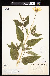 Heliopsis helianthoides var. scabra (Dunal) Fernald 210512[1046579]Wheeler, William 3301899-00-00 United States, Minnesota, Houston, Crooked Creek;Dorer Memorial Hardwood State Forest;;;, 43.62916 -91.318526 |
MIN:Plants | 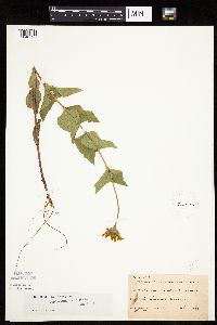 Heliopsis helianthoides var. scabra (Dunal) Fernald 210516[1046525]Sheldon, Edmund S26931892-07-00 United States, Minnesota, Crow Wing, Brainerd;;N;;, 46.348453 -94.240593 |
MIN:Plants | 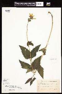 Heliopsis helianthoides var. scabra (Dunal) Fernald 210517[1046562]Taylor, B. T3141891-06-00 United States, Minnesota, Waseca, Janesville;;N;;, 44.116078 -93.708004 |
MIN:Plants | 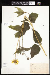 Heliopsis helianthoides var. scabra (Dunal) Fernald 210518[1046461]Ballard, C. B6321891-07-00 United States, Minnesota, Carver, Chaska;;N;;, 44.789407 -93.602179 |
MIN:Plants | 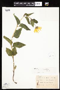 Heliopsis helianthoides var. scabra (Dunal) Fernald 210519[1046463]Ballard, C. B3201891-06-00 United States, Minnesota, Scott, Belle Plaine;;N;;, 44.622741 -93.768573 |
MIN:Plants | 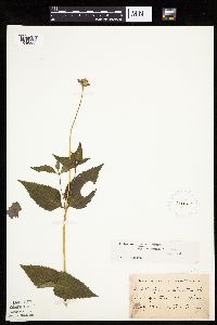 Heliopsis helianthoides var. scabra (Dunal) Fernald 210521[1046555]Menzel, Max s.n.1892-07-00 United States, Minnesota, Pipestone, Pipestone City;;106N;46W;12, 44.00136 -96.31763 |
MIN:Plants | 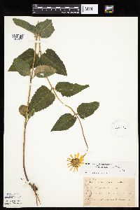 Heliopsis helianthoides var. scabra (Dunal) Fernald 210522[1046553]Ballard, C. B1971891-06-00 United States, Minnesota, Scott, Jordan, Scott Co.;;114N;23W;, 44.674435 -93.582701 |
MIN:Plants | 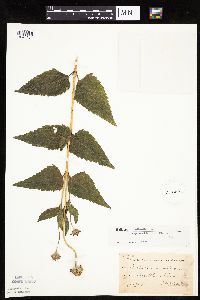 Heliopsis helianthoides var. scabra (Dunal) Fernald 210523[1046484]Sheldon, Edmund S11951891-07-00 United States, Minnesota, Brown, New Ulm;;N;;, 44.326359 -94.431802 |
MIN:Plants | 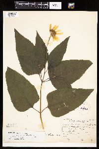 Heliopsis helianthoides var. scabra (Dunal) Fernald 222144[1047271]Roberts, Thomas s.n.1904-07-09 United States, Minnesota, Wabasha, Brook Lodge;;N;;, 44.28 -92.24 |
MIN:Plants | 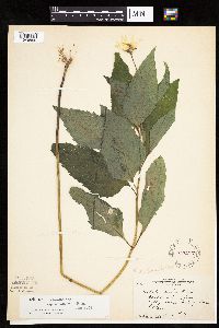 Heliopsis helianthoides var. scabra (Dunal) Fernald 222217[1046559]Rosendahl, C. 53661927-00-00 United States, Minnesota, Fillmore, 3 - 4 mi N of Choice, Fillmore Co.;Dorer Memorial Hardwood State Forest;103N;08W;, 43.717013 -91.790284 |
MIN:Plants | 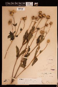 Heliopsis helianthoides var. scabra (Dunal) Fernald 222581[1286145]Holzinger, J. s.n.1886-09-00 United States, Minnesota, Winona, [no further data], 43.997785 -91.748027 |
MIN:Plants | 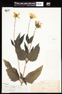 Heliopsis helianthoides var. scabra (Dunal) Fernald 223110[1046561]Manning, Sara 38791884-08-28 United States, Minnesota, Wabasha, Lake City;;N;;, 44.449412 -92.266844 |
MIN:Plants | 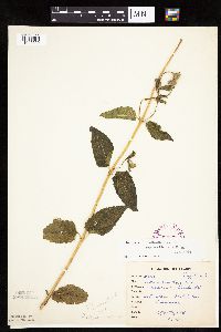 Heliopsis helianthoides var. scabra (Dunal) Fernald 265478[1046629]Goldsmith, G. G6611912-00-00 United States, Minnesota, Rice, Northfield;;N;;, 44.458298 -93.161604 |
MIN:Plants | 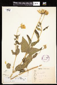 Heliopsis helianthoides var. scabra (Dunal) Fernald 265479[1046628]Goldsmith, G. G661912-00-00 United States, Minnesota, Rice, Northfield;;N;;, 44.458298 -93.161604 |
MIN:Plants | 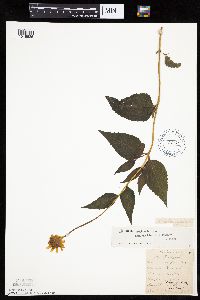 Heliopsis helianthoides var. scabra (Dunal) Fernald 270048[1046626]Wheeler, William 751893-07-13 United States, Minnesota, Houston, Winnebago Valley;Dorer Memorial Hardwood State Forest;N;;, 43.630682 -91.431985 |
MIN:Plants | 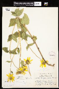 Heliopsis helianthoides var. scabra (Dunal) Fernald 275869[1046632]Grant, Martin 28321929-08-03 United States, Minnesota, Clearwater, Itasca Park. Near tourist camp. NW-NE-2 T143 R36;Itasca State Park;143N;36W;2, 47.231973 -95.201528 |
MIN:Plants | 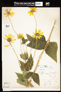 Heliopsis helianthoides var. scabra (Dunal) Fernald 277823[1046478]Roberts, Thomas s.n.1889-08-02 United States, Minnesota, Hennepin, Minneapolis;;N;;, 44.979965 -93.263836 |
MIN:Plants | 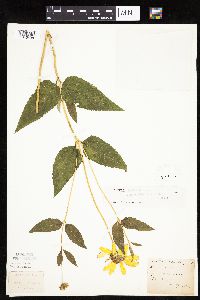 Heliopsis helianthoides var. scabra (Dunal) Fernald 277830[1046498]Roberts, Thomas s.n.1887-08-02 United States, Minnesota, Hennepin, Minneapolis;;N;;, 44.979965 -93.263836 |
MIN:Plants | 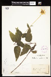 Heliopsis helianthoides var. scabra (Dunal) Fernald 281371[1046497]Roberts, Thomas s.n.1878-08-21 United States, Minnesota, Hennepin, Minneapolis;;N;;, 44.979965 -93.263836 |
MIN:Plants | 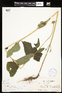 Heliopsis helianthoides var. scabra (Dunal) Fernald 350054[1046456]Nielsen, E. 21151933-07-05 United States, Minnesota, Becker, Lake Sally road W of Lake Munson, Detroit Lakes;;138N;41W;, 46.760408 -95.858857 |
MIN:Plants | 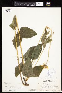 Heliopsis helianthoides var. scabra (Dunal) Fernald 350056[1046502]Nielsen, E. 21051933-07-05 United States, Minnesota, Becker, Lake Munson, Detroit Lakes;;138N;41W;, 46.760408 -95.858857 |
MIN:Plants | 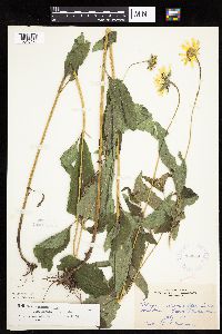 Heliopsis helianthoides var. scabra (Dunal) Fernald 350850[1046473]Hedman, H. 331938-07-00 United States, Minnesota, Hennepin, N shore Brown's Bay, L. Minnetonka;;117N;23W;, 44.934923 -93.584208 |
MIN:Plants | 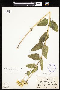 Heliopsis helianthoides var. scabra (Dunal) Fernald 350956[1046577]Nielsen, E. 17211932-09-20 United States, Minnesota, Scott, Railroad, 1 mi W of Savage;;;;, 44.753605 -93.344349 |
MIN:Plants | 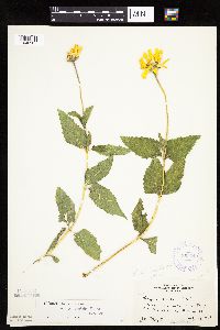 Heliopsis helianthoides var. scabra (Dunal) Fernald 353510[1046585]Moyle, J. 13411934-07-18 United States, Minnesota, Pennington, 24.5 mi S of Thief River Falls, on Hwy.22;;N;;, 48.137191 -96.175395 |
MIN:Plants | 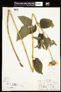 Heliopsis helianthoides var. scabra (Dunal) Fernald 353979[1046563]Lakela, Olga 26681938-08-04 United States, Minnesota, Saint Louis, Enger Golf Course at Skyline Parkway, Duluth;;N;;, 46.811579 -92.119043 |
MIN:Plants |  Heliopsis helianthoides var. scabra (Dunal) Fernald 357008[1046536]Stevenson, J. 1721912-07-15 United States, Minnesota, Beltrami, Bemidji;;N;;, 47.453829 -94.863614 |
MIN:Plants | 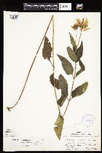 Heliopsis helianthoides var. scabra (Dunal) Fernald 360211[1046506]Lakela, Olga 41921940-09-01 United States, Minnesota, Saint Louis, Mission Creek, by a lily pond, Fond du Lac;;N;;, 46.657011 -92.257257 |
MIN:Plants | 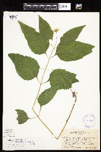 Heliopsis helianthoides var. scabra (Dunal) Fernald 360763[1046558]Rosendahl, C. 67981937-06-29 United States, Minnesota, Fillmore, S side of Root River, top of bluff, 1 1/2 mi W of Peterson, Minn.;;104N;08W;, 43.803542 -91.790268 |
MIN:Plants | 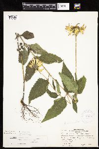 Heliopsis helianthoides var. scabra (Dunal) Fernald 366622[1046495]Rosendahl, C.; et al. 73541939-09-13 United States, Minnesota, Sibley, Between railroad track & the highway; between Gaylord & Winthrop;;;;, 44.543359 -94.294587 |
MIN:Plants | 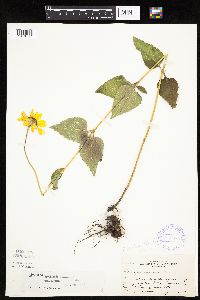 Heliopsis helianthoides var. scabra (Dunal) Fernald 369885[1046447]Moore, John 130381940-06-19 United States, Minnesota, Nicollet, Railroad right of way; 6 mi E of Courtland, Nicollet Co.;;109N;28W;, 44.239687 -94.190492 |
MIN:Plants | 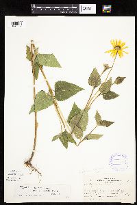 Heliopsis helianthoides var. scabra (Dunal) Fernald 369904[1046582]Moore, John 130191940-06-19 United States, Minnesota, Blue Earth, Railroad right of way; NW1/4, Sec.12, Mankato Twp.;;108N;26W;12, 44.174104 -93.898723 |
MIN:Plants | 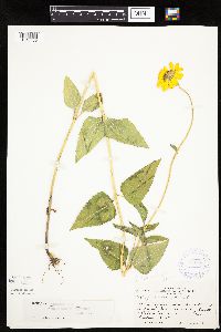 Heliopsis helianthoides var. scabra (Dunal) Fernald 370726[1046455]Moore, John; et al. 133001940-06-27 United States, Minnesota, McLeod, Chicago, Milwaukee & St. Paul railroad, 1 mi W of Sumpter;;;;, 44.756389 -94.325278 |
MIN:Plants | 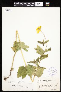 Heliopsis helianthoides var. scabra (Dunal) Fernald 371223[1046499]Moore, John 131711940-06-21 United States, Minnesota, Big Stone, Just W of Hwy.75; 2 1/2 mi S of Ortonville;;N;;, 45.268486 -96.444779 |
MIN:Plants | 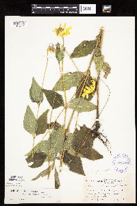 Heliopsis helianthoides var. scabra (Dunal) Fernald 371301[1046617]Moore, John; et al. 146791941-07-06 United States, Minnesota, Douglas, Douglas County...1 mi S of Garfield;;;;, 45.889822 -95.448171 |
MIN:Plants | 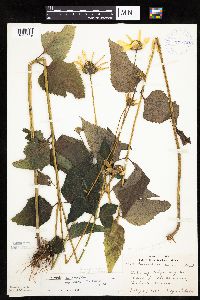 Heliopsis helianthoides var. scabra (Dunal) Fernald 371659[1046449]Lakela, Olga 46241941-07-29 United States, Minnesota, Lake, Along Hwy.61 near Little Marais;;N;;, 47.409711 -91.120321 |
MIN:Plants | 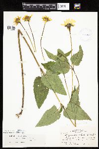 Heliopsis helianthoides var. scabra (Dunal) Fernald 381319[1046560]Moore, John; et al. 154871942-06-20 United States, Minnesota, Rice, Nerstrand Woods, 3 mi W of Nerstrand. Rice Co.;Nerstrand Woods State Park;110N;19W;09, 44.34887 -93.11108 |
MIN:Plants | 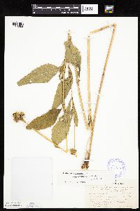 Heliopsis helianthoides var. scabra (Dunal) Fernald 385655[1046586]Lakela, Olga 58151944-08-21 United States, Minnesota, Lake, Near Gooseberry River on the interior road from Beaver Bay to Stewart River;North Shore;054N;10W;11, 47.177893 -91.569241 |
MIN:Plants | 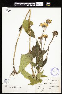 Heliopsis helianthoides var. scabra (Dunal) Fernald 386061[1046538]Moyle, J. 40451941-08-03 United States, Minnesota, Freeborn, S of Albert Lea;;N;;, 43.648013 -93.368266 |
MIN:Plants | 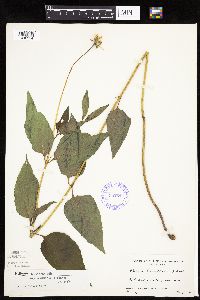 Heliopsis helianthoides var. scabra (Dunal) Fernald 387240[1046554]Linnaean Club, U of M, 2741943-07-10 United States, Minnesota, Rice, Nerstrand Woods. Rice Co. S of main road.;Nerstrand Woods State Park;110N;19W;, 44.327064 -93.100886 |
MIN:Plants | 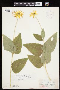 Heliopsis helianthoides var. scabra (Dunal) Fernald 396859[1046545;1046544]Stevens, O. 10181947-07-11 United States, Minnesota, Clay, Buffalo State Park. Clay Co.;Buffalo River State Park;139N;46W;10, 46.869327 -96.473428 |
Google Map
Google Maps is a web mapping service provided by Google that features a map that users can pan (by dragging the mouse) and zoom (by using the mouse wheel). Collection points are displayed as colored markers that when clicked on, displays the full information for that collection. When multiple species are queried (separated by semi-colons), different colored markers denote each individual species.