University of Minnesota
http://www.umn.edu/
612-625-5000
http://www.umn.edu/
612-625-5000
Minnesota Biodiversity Atlas
Bell Museum
Dataset: MIN-Plants
Taxa: Lomatium
Search Criteria: excluding cultivated/captive occurrences
1
Page 1, records 1-56 of 56
Bell Museum plants | |
 MIN:Plants |  Lomatium triternatum (Pursh) J.M. Coulter & Rose 794631[1035078]Schaaf, J. 3111982-07-12 United States, Nevada, Humboldt, Pine Forest Range, 1859m |
MIN:Plants | Lomatium dasycarpum (Torrey & A. Gray) J.M. Coulter & Rose 511003[]Univ. of Calif. Bot. Gard. list 17 - 1001974-00-00 United States, California, Lake, Lake Co. |
MIN:Plants |  Lomatium orientale J.M. Coulter & Rose 488835[1035075]Bosch, T. 22001-04-29 United States, Minnesota, Big Stone, Big Stone County ... T120N R45W sec. 1-2 ... Approx. 0.5 mile east of Hwy. 75 and 2 miles south of Hwy. 7.;;120N;45W;01, 45.2325 -96.236536 |
MIN:Plants |  Lomatium orientale J.M. Coulter & Rose 488033[1035039]Bosch, T. 242001-05-25 United States, Minnesota, Big Stone, Approx. 0.5 mile east of Hwy. 75 and 2 miles south of Hwy. 7.;;120N;45W;01, 45.2325 -96.236536 |
MIN:Plants | Lomatium grayi (J.M. Coulter & Rose) J.M. Coulter & Rose 510998[]Davis, Owen s.n.1978-08-28 United States, Idaho, Bingham, [no further data] |
MIN:Plants |  Lomatium orientale J.M. Coulter & Rose 164338[1035077]Moyer, Lycurgus 26451894-04-26 United States, Minnesota, Chippewa, Montevideo;;117N;40W;, 44.934626 -95.675774 |
MIN:Plants |  Lomatium orientale J.M. Coulter & Rose 164339[1035076]Moyer, Lycurgus s.n.1893-05-00 United States, Minnesota, Chippewa, Montevideo;;117N;40W;, 44.934626 -95.675774 |
MIN:Plants |  Lomatium orientale J.M. Coulter & Rose 164340[1035056]Menzel, Max s.n.1896-05-00 United States, Minnesota, Pipestone, Pipestone [assuming the quarry area; town generally noted as "Pipestone City" by collector];Pipestone National Monument;106N;46W;01, 44.01585 -96.31767 |
MIN:Plants |  Lomatium orientale J.M. Coulter & Rose 164341[1035068]Payne, F. s.n.1890-04-00 United States, Minnesota, Swift, Appleton;;120N;43W;, 45.195938 -96.04182 |
MIN:Plants |  Lomatium orientale J.M. Coulter & Rose 164342[1035046]Nelson, Nels s.n.1894-00-00 United States, Minnesota, Chippewa, Montevideo;;117N;40W;, 44.934626 -95.675774 |
MIN:Plants | 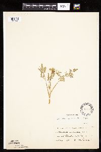 Lomatium orientale J.M. Coulter & Rose 164343[1035048]Wirkrrshrim, W. s.n.1890-05-00 United States, Minnesota, Lincoln, Ash Lake;;N;;, 44.422973 -96.294773 |
MIN:Plants | 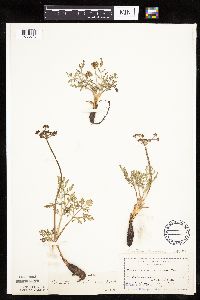 Lomatium orientale J.M. Coulter & Rose 164346[1035045]Moyer, Lycurgus s.n.1894-04-00 United States, Minnesota, Chippewa, Montevideo;;117N;40W;, 44.934626 -95.675774 |
MIN:Plants | 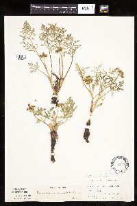 Lomatium orientale J.M. Coulter & Rose 164347[1035047]Moyer, Lycurgus s.n.1896-04-26 United States, Minnesota, Chippewa, Montevideo;;117N;40W;, 44.934626 -95.675774 |
MIN:Plants | 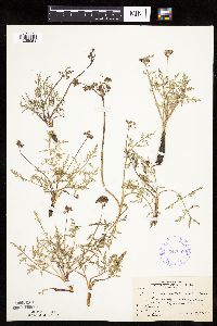 Lomatium orientale J.M. Coulter & Rose 349088[1035051]Rosendahl, C.; et al. 30541935-05-19 United States, Minnesota, Pipestone, 2nd quartzite outcrop, near Pipestone;Pipestone National Monument;106N;46W;, 43.979723 -96.367859 |
MIN:Plants | 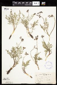 Lomatium orientale J.M. Coulter & Rose 352413[1035049]Rosendahl, C.; et al. 30001935-05-19 United States, Minnesota, Pipestone, Pipestone quarries, Pipestone;Pipestone National Monument;106N;46W;, 43.979723 -96.367859 |
MIN:Plants | 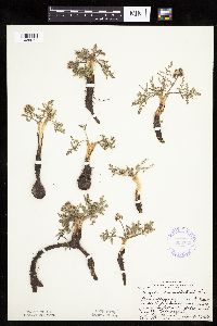 Lomatium orientale J.M. Coulter & Rose 356732[1035071]Moore, John; et al. 123131940-04-27 United States, Minnesota, Cottonwood, Creek 8 mi. S of Sanborn, 1 mi. W of Hwy. 71. Cottonwood Co.;;;;, 44.198155 -95.121401 |
MIN:Plants | 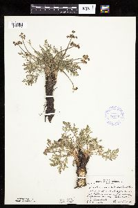 Lomatium orientale J.M. Coulter & Rose 356738[1035067]Moore, John; et al. 123071940-04-26 United States, Minnesota, Pipestone, Pipestone Co.; Pipestone;;106N;46W;, 43.979723 -96.367859 |
MIN:Plants | 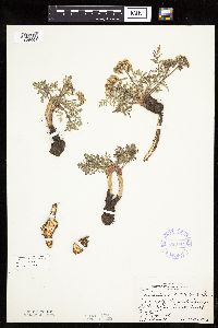 Lomatium orientale J.M. Coulter & Rose 356741[1035064]Moore, John; Phinney, Bernard 123041940-04-26 United States, Minnesota, Rock, Mound Springs State Park;Blue Mounds State Park;;;, 43.706667 -96.186944 |
MIN:Plants |  Lomatium orientale J.M. Coulter & Rose 367942[1035055]Moore, John; et al. 128981940-05-28 United States, Minnesota, Big Stone, Near hwy 75, 1.5 mi SE of Ortonville. Big Stone Co.;;;;, 45.289326 -96.422942 |
MIN:Plants |  Lomatium orientale J.M. Coulter & Rose 367949[1035053]Moore, John; et al. 128591940-05-27 United States, Minnesota, Traverse, 6 mi SW of Wheaton, on hwy 27. Traverse Co.;;;;, 45.742941 -96.587354 |
MIN:Plants |  Lomatium orientale J.M. Coulter & Rose 368290[1035052]Moore, John; et al. 129141940-05-28 United States, Minnesota, Swift, Along the rr right of way, near Danvers;;;;, 45.281905 -95.751984 |
MIN:Plants |  Lomatium orientale J.M. Coulter & Rose 396842[1035050]Stevens, O. s.n.1947-05-25 United States, Minnesota, Clay, [no further data];Buffalo River State Park;139N;46W;10, 46.869327 -96.473428 |
MIN:Plants |  Lomatium orientale J.M. Coulter & Rose 445988[1035054]Moore, John; et al. 173711945-06-20 United States, Minnesota, Red Lake, Red Lake County...4 mi W of Marcoux;;150N;44W;, 47.80355 -96.28794 |
MIN:Plants |  Lomatium orientale J.M. Coulter & Rose 476564[1035058]Abbott, Robinson; et al. s.n.1991-04-25 United States, Minnesota, Pope, Pope County...N. Baby Lake, Sect. E. Glacial Lake St. Pk, 5 mi. SSE of Starbuck.;Glacial Lakes State Park;124N;39W;, 45.542094 -95.562177 |
MIN:Plants |  Lomatium orientale J.M. Coulter & Rose 484678[1035057]Abbott, Robinson s.n.1962-05-22 United States, Minnesota, Stevens, Stevens County...RR. tracks, 3 mi. W. of Cyrus on rt. 28.;;125N;41W;00, 45.628995 -95.820171 |
MIN:Plants |  Lomatium orientale J.M. Coulter & Rose 488677[1035065]Moore, John 200661949-06-02 United States, Minnesota, Clay, 6 mi. W of Hawley;;N;;, 46.880723 -96.443807 |
MIN:Plants | 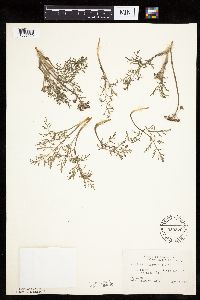 Lomatium orientale J.M. Coulter & Rose 550879[1035070]Cotter, Shirley 14521950-05-14 United States, Minnesota, Yellow Medicine, W of Granite Falls;;N;;, 44.809958 -95.545575 |
MIN:Plants | 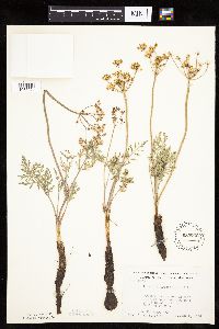 Lomatium orientale J.M. Coulter & Rose 553766[1035074]Moore, John; et al. 227691956-06-08 United States, Minnesota, Clay, Clay County...On W side of road near old sand pit, 3/4 mi. N of Muskoda Station [historic RR station near Hawley];;139N;45W;07, 46.868751 -96.413947 |
MIN:Plants | 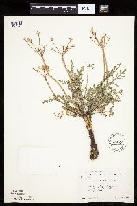 Lomatium orientale J.M. Coulter & Rose 554593[1035044]Moore, John 231731957-06-12 United States, Minnesota, Pipestone, On Sioux Quartzite outcrop, 1.5 mi N of Pipestone;Pipestone National Monument;106N;46W;, 43.979723 -96.367859 |
MIN:Plants | 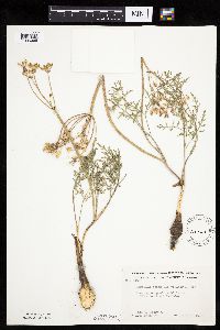 Lomatium orientale J.M. Coulter & Rose 568669[1035066]Moore, John; Ferguson, A. 249601960-06-07 United States, Minnesota, Blue Earth, 1 mi. S of Mankato;;N;;, 44.149094 -93.9994 |
MIN:Plants |  Lomatium orientale J.M. Coulter & Rose 592086[1035069]Moore, John 266761964-06-03 United States, Minnesota, Pipestone, W of the r.r. track, Pipestone National Monument;Pipestone National Monument;106N;46W;, 43.979723 -96.367859 |
MIN:Plants |  Lomatium orientale J.M. Coulter & Rose 693912[1035072]Roefer, Florence s.n.1978-05-25 United States, Minnesota, Cottonwood, Jeffers Petroglyph Historic Site. T107N, R35W, NW1/4 Sec. 9, Delton Twp.;Jeffers Petroglyphs Historical Site;107N;35W;9, 44.086452 -95.049966 |
MIN:Plants |  Lomatium orientale J.M. Coulter & Rose 693913[1035073]Roefer, Florence s.n.1978-04-14 United States, Minnesota, Cottonwood, Jeffers Petroglyph Historic Site. T107N, R35W, NW1/4 NW1/4 Sec. 9, Delton Twp.;Jeffers Petroglyphs Historical Site;107N;35W;9, 44.086452 -95.049966 |
MIN:Plants |  Lomatium orientale J.M. Coulter & Rose 729314[1035063]Burrell, E.; et al. 15091981-06-06 United States, Minnesota, Nicollet, Nicollet County...S of old house; T111N R32W E1/2 SW1/4 Sec. 15;;111N;32W;15, 44.420061 -94.674297 |
MIN:Plants | 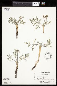 Lomatium orientale J.M. Coulter & Rose 739969[1035042]Converse, C. 7171982-04-28 United States, Minnesota, Chippewa, Chippewa and Swift Cos. Chippewa Prairie; NW1/4 SW1/4 Sec. 12 T119N R43W;Chippewa Prairie, The Nature Conservancy;119N;43W;12, 45.130213 -95.990566 |
MIN:Plants | 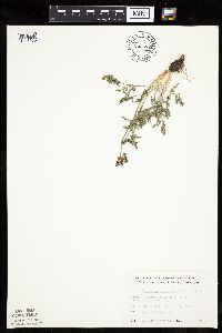 Lomatium orientale J.M. Coulter & Rose 743572[1035060]Nietering, E. 361982-05-03 United States, Minnesota, Chippewa, Chippewa Co. SE of Granite Falls; NW1/4 NE1/4 Sec. 14 T115N R39W;;115N;39W;14, 44.765344 -95.513159 |
MIN:Plants | 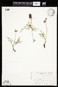 Lomatium orientale J.M. Coulter & Rose 743579[1035033]Nietering, E.; et al. 461982-05-08 United States, Minnesota, Redwood, Redwood County...N of Belview; SW1/4 SE1/4 Sec. 17 T114N R37W;;114N;37W;17, 44.679459 -95.329738 |
MIN:Plants | 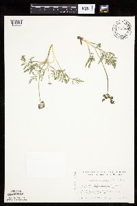 Lomatium orientale J.M. Coulter & Rose 743580[1035037]Nietering, E. 531982-05-11 United States, Minnesota, Redwood, Redwood Co. E of North Redwood; SE1/4 SE1/4 Sec. 28 T113N R35W;;113N;35W;28, 44.562549 -95.066885 |
MIN:Plants |  Lomatium orientale J.M. Coulter & Rose 743581[1035031]Nietering, E. 321982-05-03 United States, Minnesota, Chippewa, Chippewa Co. SE of Montevideo; SW1/4 SW1/4 Sec. 21 T117N R40W;;117N;40W;21, 44.927352 -95.686193 |
MIN:Plants |  Lomatium orientale J.M. Coulter & Rose 743582[1035061]Nietering, E. 411982-05-04 United States, Minnesota, Redwood, Redwood Co. N of Belview; NW1/4 SW1/4 Sec. 21 T114N R37W;;114N;37W;21, 44.664538 -95.310268 |
MIN:Plants |  Lomatium orientale J.M. Coulter & Rose 743587[1035062]Nietering, E. 501982-05-11 United States, Minnesota, Renville, Renville Co. S of Renville, on banks of Backendorf Lake; SW1/4 NE1/4 Sec. 29 T114N R36W;;114N;36W;29, 44.644569 -95.214969 |
MIN:Plants |  Lomatium orientale J.M. Coulter & Rose 743588[1035035]Nietering, E.; et al. 1831982-05-02 United States, Minnesota, Renville, Renville County...Along co. rd 15, ca. 1/4 mi E of intersection with co. rd 1, N of North Redwood; NE1/4 SE1/4 Sec. 20 T113N R35W. 113N 35W 20, 44.578346 -95.085406 |
MIN:Plants |  Lomatium orientale J.M. Coulter & Rose 743678[1035034]Nietering, E. 191982-05-02 United States, Minnesota, Renville, Renville Co. Morton Outcrop (60); NW1/4 NW1/4 Sec. 31 T113N R35W;;113N;35W;31, 44.55135 -94.984439 |
MIN:Plants |  Lomatium orientale J.M. Coulter & Rose 743679[1035036]Nietering, E. 081982-04-29 United States, Minnesota, Redwood, Redwood Co. Along E side of co. rd 11, S of Franklin; SE1/4 SE1/4 Sec. 14 T112N R34W;;112N;34W;14, 44.506793 -94.895945 |
MIN:Plants |  Lomatium orientale J.M. Coulter & Rose 743682[1035032]Nietering, E. 0171982-04-29 United States, Minnesota, Brown, NW1/4 SW1/4 Sec. 19 T112N R33W;;112N;33W;19, 44.48977 -94.857039 |
MIN:Plants |  Lomatium orientale J.M. Coulter & Rose 747555[1035059]Nietering, E. 2331983-05-13 United States, Minnesota, Redwood, Redwood Co. In area of granite outcrops, just W of co. rd 11, S of Wabasha Creek; SE1/4 SE1/4 Sec. 14 T112N R34W;;112N;34W;14, 44.506793 -94.895945 |
MIN:Plants | 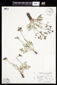 Lomatium orientale J.M. Coulter & Rose 757928[1035040]Smith, Welby 58771982-05-08 United States, Minnesota, Lac Qui Parle, Antelope Hills, ca. 7.5 mi due W of Providence; SW1/4 NE1/4 Sec. 27 T116N R45W;;116N;45W;27, 44.827179 -96.265974 |
MIN:Plants | 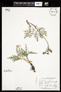 Lomatium orientale J.M. Coulter & Rose 758117[1035043]Smith, Welby 59021982-05-14 United States, Minnesota, Pope, Glacial Lakes State Park. Glacial Lakes State Park, on the E side of co. hwy 41, ca. 5 1/4 mi S of its jnc with st. hwy 28 in Starbuck; W1/2 NE1/4 Glacial Lakes State Park, on the E side of co. hwy 41, ca. 5 1/4 mi S of its jnc with st. hwy 28 in Starbuck; W1/2 NE1/4 Sec. 23 T124N R39W. 124N 39W 23, 45.534841 -95.531366 |
MIN:Plants | 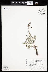 Lomatium orientale J.M. Coulter & Rose 780501[1035041]Ownbey, Gerald 68801983-05-16 United States, Minnesota, Lac Qui Parle, Antelope Hills prairie; T116N R45W Sec. 27 W1/2 NE1/4;;116N;45W;27, 44.827179 -96.265974 |
MIN:Plants | 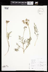 Lomatium orientale J.M. Coulter & Rose 796583[1035038]Sather, Nancy 86-0241986-05-16 United States, Minnesota, Cottonwood, Red Rock Prairie, The Nature Conservancy. Cottonwood County...Red Rock Preserve, ca. 5.5 mi E of US hwy 71, NE of Jeffers, SE of Sanborn, near rock outcrops at western edge of tract...T107N R35W Sec. 11 SW1/4 NE1/4. 107N 35W 11, 44.0877762 -95.0074997 |
MIN:Plants |  Lomatium grayi (J.M. Coulter & Rose) J.M. Coulter & Rose 510895[1122268]Bright, R. 74-261974-00-00 United States, Idaho, Caribou, [no further data] |
MIN:Plants | Lomatium dissectum var. multifidum (Nuttall) Mathias & Constance 511002[]Bright, R. 74-1511974-00-00 United States, Idaho, Franklin, [no further data] |
MIN:Plants | Lomatium macrocarpum (Nuttall ex Torrey & A.Gray) J.M.Coulter & Rose 510894[]Univ. of Calif. Bot. Gard. list 17 - 1011974-00-00 United States, California, San Mateo, San Mateo Co. |
MIN:Plants | Lomatium foeniculaceum (Nuttall) J.M. Coulter & Rose 510999[]Davis, Owen s.n.1978-08-28 United States, Idaho, Bingham, [no further data] |
MIN:Plants |  Lomatium idahoense Mathias & Cronquist 371745[1001650]Cronquist, A. 28561941-07-03 United States, Idaho, Custer, Beaver Creek near Marsh Creek, 25 miles N.W. of Stanley, 1951m |
MIN:Plants |  Lomatium utriculatum (Nutt. ex Torr. & A. Gray) J.M. Coult. & Rose 951902[1290401]Lawrence, D. B. 971930-07-02 United States, Colorado, Gunnison, Gothic. Rocky Mountain Biological Station. |
1
Page 1, records 1-56 of 56
Google Map
Google Maps is a web mapping service provided by Google that features a map that users can pan (by dragging the mouse) and zoom (by using the mouse wheel). Collection points are displayed as colored markers that when clicked on, displays the full information for that collection. When multiple species are queried (separated by semi-colons), different colored markers denote each individual species.