University of Minnesota
http://www.umn.edu/
612-625-5000
http://www.umn.edu/
612-625-5000
Minnesota Biodiversity Atlas
Bell Museum
Dataset: MIN-Plants
Taxa: Pastinaca
Search Criteria: excluding cultivated/captive occurrences
1
Page 1, records 1-82 of 82
Bell Museum plants | |
 MIN:Plants |  912061[1035535]Smith, Welby 254411994-09-08 United States, Minnesota, Beltrami, Beltrami County...At the Waskish Municipal Campground...between Hwy 72 and adjacent pine forest...T 154N R 30W SE1/4 of NE1/4 of Sec 8. 154N 30W 8, 48.1722222 -94.5116667 |
MIN:Plants |  897980[1035530]Smith, Welby 156721989-07-11 United States, Minnesota, Kanabec, Mille Lacs Wildlife Management Area. Kanabek County ... Mille Lacs State Wildlife Management Area, about 9 miles northwest of Mora ...SW1/4 SW1/4 section 16, T40N R25W. 040N 25W 16, 45.9511111 -93.4711111 |
MIN:Plants |  491148[1035504]Juhnke, C. 322 CMJ FRO1999-06-09 United States, Minnesota, Goodhue, Frontenac State Park Goodhue County ... Along Cty. Rd. 2 near monument wayside along Hwy. 61 ... T112N R13W SE SW SW 13;Frontenac State Park;112N;13W;13, 44.505359 -92.319092 |
MIN:Plants |  911925[1035558]Smith, Welby 230491993-07-21 United States, Minnesota, Meeker, Meeker County...On the south side of T.H. 12; about 2 miles southeast of Darwin...T 119N R 30W NW1/4 of SE1/4 of Sec 25;;119N;30W;25, 45.0872222 -94.3916667 |
MIN:Plants |  916906[1035528]Smith, Welby 224491993-06-18 United States, Minnesota, Grant, Grant County ... South side of Ask Lake, about 1.5 miles east-southeast of Ashby ... T130N R41W NW1/4 of SW1/4 of Sec 12;;130N;41W;12, 46.0847222 -95.7886111 |
MIN:Plants |  914515[1035534]Smith, Welby 251241994-08-16 United States, Minnesota, Itasca, Itasca County...At Bowstring Lodge, on the north side of Bowstring Lake...T 147N R 25W SW1/4 of SW1/4 of Sec 6;Chippewa National Forest;147N;25W;06, 47.5716667 -93.9030556 |
MIN:Plants |  477527[1035547]Smith, Welby 172071990-07-12 United States, Minnesota, Fillmore, Fillmore County ... On the southwest side of State Highway 63, about 6 miles northeast of LeRoy ... T101N R13W NW1/4 of NW1/4 of Sec 15. 101N 13W 15, 43.5558319 -92.3866653 |
MIN:Plants |  164593[1035527]Skinner, S. 1291902-06-17 United States, Minnesota, Jackson, Heron Lake Region;;N;;, 43.753807 -95.256418 |
MIN:Plants |  164608[1122403]Wilkinson, E. s.n. United States, Minnesota, [no further data];;;;, 46 -94 |
MIN:Plants |  164609[1035567]Manning, Sara s.n.1886-07-28 United States, Minnesota, Wabasha, Lake City;;N;;, 44.4081 -92.252454 |
MIN:Plants |  164610[1122402]Sandberg, John s.n.1890-06-00 United States, Minnesota, Hennepin, [no further data];;;;, 45 -93.47 |
MIN:Plants |  164611[1035562]Ballard, C. s.n.1900-08-00 United States, Minnesota, Kittson, St. Vincent;;163N;51W;, 48.945898 -97.210703 |
MIN:Plants |  164613[1122404]Aiton, G. s.n.1889-07-00 United States, Minnesota, Hennepin, [no further data];;;;, 45 -93.47 |
MIN:Plants |  164614[1035532]Kassube, J. s.n.1878-06-00 United States, Minnesota, Hennepin, Minneapolis;;N;;, 44.979965 -93.263836 |
MIN:Plants |  164615[1035550]Sandberg, John s.n.1885-08-00 United States, Minnesota, Goodhue, Red Wing;;N;;, 44.555216 -92.495543 |
MIN:Plants |  264360[1035529]Holzinger, John s.n.1897-10-01 United States, Minnesota, Winona, Winona Co.;;N;;, 43.972094 -91.701335 |
MIN:Plants |  265472[1035564]Goldsmith, G. G991912-00-00 United States, Minnesota, Rice, Northfield;;N;;, 44.458298 -93.161604 |
MIN:Plants |  288420[1035551]Johnson, Renb. s.n.1914-06-24 United States, Minnesota, Hennepin, Fort Snelling;Fort Snelling Military Reservation;N;;, 44.905162 -93.166462 |
MIN:Plants |  332610[1035524]Grant, Martin 67031935-08-29 United States, Minnesota, Beltrami, Cass lake, Beltrami Co.;Chippewa National Forest / Leech Lake Indian Reservation;146N;30W;28, 47.43333 -94.490576 |
MIN:Plants |  336276[1122399]Oestlund, O. 61-11888-08-24 United States, Minnesota, Hennepin, [no further data];;;;, 45 -93.47 |
MIN:Plants |  336277[1122400]Oestlund, O. s.n.1888-08-24 United States, Minnesota, Hennepin, [no further data];;;;, 45 -93.47 |
MIN:Plants |  349656[1035531]Hedman, H. 191938-07-00 United States, Minnesota, Hennepin, N shore Brown's Bay, L. Minnetonka;;N;;, 44.95982 -93.55047 |
MIN:Plants |  354251[1035548]Moyle, J. 14781934-07-09 United States, Minnesota, Hubbard, Itasca Park, near NE corner;Itasca State Park;143N;35W;, 47.195787 -95.107789 |
MIN:Plants |  367007[1035561]Moore, John; Butters, F. 135241940-09-05 United States, Minnesota, Cass, S shore of Leech Lake, 1/2 mi E of Whipholt;Chippewa National Forest / Leech Lake Indian Reservation;141N;29W;, 47.022752 -94.346119 |
MIN:Plants |  393205[1035563]Ownbey, Gerald; et al. 11361948-08-18 United States, Minnesota, Cook, Cook County...N promentory of Susie Island, Susie Islands near Grand Portage;North Shore / Susie Islands, The Nature Conservancy;063N;07E;, 47.973776 -89.578978 |
MIN:Plants |  401392[1035565]Brown, Spencer s.n.1935-00-00 United States, Minnesota, Cook, Grand Portage, T63N, R6E;Grand Portage Indian Reservation / North Shore;063N;06E;, 47.958468 -89.703576 |
MIN:Plants |  407568[1035552]Lakela, Olga 87191949-07-04 United States, Minnesota, Saint Louis, Hwy No. 4 S of Island Lake;;N;;, 47.01085 -92.14499 |
MIN:Plants |  409183[1035514]Moore, John; Moore, Marjorie 112771939-07-29 United States, Minnesota, Lake of the Woods, near Fort St. Charles, Magnuson Island;Northwest Angle;168N;34W;, 49.344621 -95.028893 |
MIN:Plants |  452069[1035555]Aisawa, Saburo s.n.1952-07-20 United States, Minnesota, Ramsey, Ramsey Co.; across from power plant on Larpenteur Ave in Roseville Twp, Minneapolis, St. Paul;;029N;23W;, 44.992077 -93.166387 |
MIN:Plants | 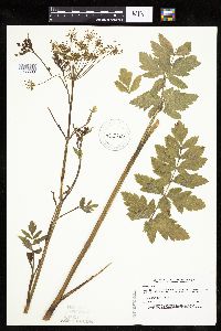 455880[1035503]Lee, Michael MDL1931993-06-22 United States, Minnesota, Dakota, Dakota Co.; 3 miles SE of Hampton, west of U.S. 52; T 113N R 18W SW1/4 of NE1/4 of Sec 27;;113N;18W;27, 44.565027 -92.964473 |
MIN:Plants | 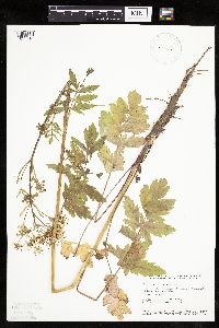 458627[1035513]Smith, Welby 154461989-06-25 United States, Minnesota, Freeborn, Myre Big Island State Park. Freeborn County...Helmer Myre State Park, about 2 miles southeast of Albert Lea. On 'Big Island' in Albert Lea Lake; SW1/4 NW1/4 sec.19, T102N R20W. 102N 20W 19, 43.625 -93.2875 |
MIN:Plants | 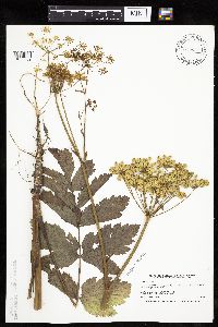 506850[1035509]Smith, Welby 170981990-06-28 United States, Minnesota, Waseca, Mueller Wildlife Management Area. Waseca Co. Mueller State Wildlife Management Area, about 2 mi NE of Waldorf; la.t43 57'55'N long.93 40'2'W, T106N R24W S Waseca Co. Mueller State Wildlife Management Area, about 2 mi NE of Waldorf; la.t43 57'55'N long.93 40'2'W, T106N R24W SE1/4 of SE1/4 of Sec 23. 106N 24W 23, 43.971322 -93.677241 |
MIN:Plants | 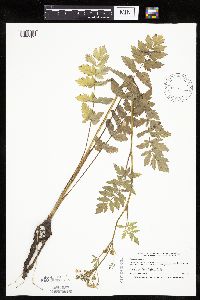 508361[1035502]Smith, Welby 169351990-06-20 United States, Minnesota, Dodge, Pheasants Forever Wildlife Management Area. Dodge Co.; 'Pheasants Forever' State Wildlife Management Area, about 2.5 mi W-SW of Mantorville; Dodge Co.; 'Pheasants Forever' State Wildlife Management Area, about 2.5 mi W-SW of Mantorville; T107N R17W SW1/4 of SE1/4 of Sec 24. 107N 17W 24, 44.0530548 -92.9300003 |
MIN:Plants |  508696[1035560]Smith, Welby 143961988-07-01 United States, Minnesota, Nobles, Nobles Co. About 2 mi SW of Worthington; on the right-of-way of the C&NW Railroad; SW1/4 SE1/4 sec.32, T102N R40W;;102N;40W;32, 43.5877762 -95.6616669 |
MIN:Plants |  514713[1035508]Smith, Welby 169801990-06-21 United States, Minnesota, Faribault, Walnut Lake Wildlife Management Area. Fairbault [sic] Co.; Walnut Lake State Wildlife Management Area. At the public access at the S side of Walnut Lake; Fairbault [sic] Co.; Walnut Lake State Wildlife Management Area. At the public access at the S side of Walnut Lake; T103N R25W SE1/4 of SW1/4 of Sec 35. 103N 25W 35, 43.681159 -93.797567 |
MIN:Plants |  520402[1035506]Smith, Welby 212481992-08-05 United States, Minnesota, Olmsted, Olmsted Co.; Bear Cave County Park, on the W side of Stewartville; T105N R14W SW1/4 of NE1/4 of Sec 33;Bear Cave County Park;105N;14W;33, 43.9263878 -92.4958344 |
MIN:Plants |  520805[1035510]Smith, Welby 193471991-07-09 United States, Minnesota, Koochiching, Koochiching Co.; at the SW corner of the intersection of TH 11 and CSAH 1, about 19 mi W of International Falls; T70N R26W NE1/4 of SW1/4 of Sec 31. 070N 26W 31, 48.5116653 -93.7338867 |
MIN:Plants | 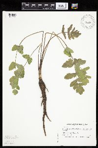 521356[1035511]Smith, Welby 185501991-05-21 United States, Minnesota, Todd, Todd Co.; about 1 mi SE of Osakis; between CSAH 46 and the BN railroad tracks; T128N R35W SW1/4 of NE1/4 of Sec 31;;128N;35W;31, 45.8549995 -95.1263885 |
MIN:Plants | 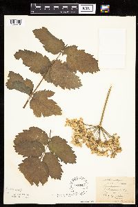 524647[1035549]Benner, J. s.n.1928-10-01 United States, Minnesota, Hennepin, Jackson Square, Mpls;;N;;, 45.010521 -93.249947 |
MIN:Plants | 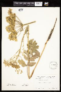 550022[1035515]Moore, John 218681954-07-20 United States, Minnesota, Wilkin, Kutzer;;N;;, 46.382741 -96.475493 |
MIN:Plants | 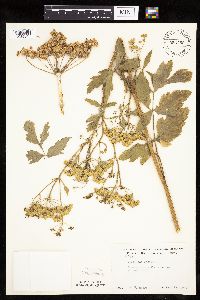 553750[1035545]Moore, John 227131955-07-28 United States, Minnesota, Becker, Becker Co. Lake Park;;139N;43W;, 46.847905 -96.112303 |
MIN:Plants | 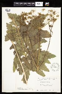 554336[1035516]Moore, John 232811957-06-18 United States, Minnesota, Martin, 1/2 mi W of Welcome;;N;;, 43.666899 -94.629433 |
MIN:Plants | 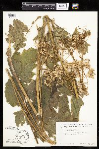 554679[1035518]Moore, John 230221956-09-13 United States, Minnesota, Clay, Barnesville;;N;;, 46.652182 -96.41979 |
MIN:Plants | 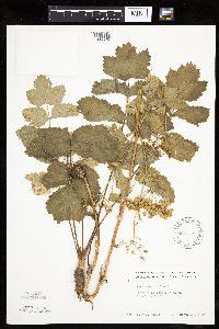 568733[1035525]Moore, John 249171959-09-30 United States, Minnesota, Blue Earth, Lake Crystal;;N;;, 44.109435 -94.202968 |
MIN:Plants | 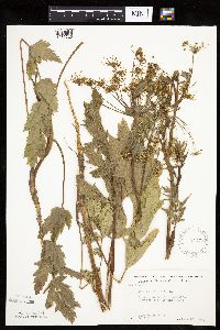 572775[1035526]Moore, John; Baker, Gary 254821961-06-22 United States, Minnesota, Houston, Houston County...4 mi E of Caledonia;Dorer Memorial Hardwood State Forest;102N;05W;00, 43.630682 -91.431985 |
MIN:Plants |  603953[1035556]Moore, John; et al. 269361966-06-22 United States, Minnesota, Pipestone, Pipestone Co.; along the north section line of S11, Gray Twp;;106N;45W;11, 44.001212 -96.214916 |
MIN:Plants |  614599[1035557]Westkaemper, Remberta s.n.1969-06-00 United States, Minnesota, Stearns, Stearns Co. Sauk Center;;126N;34W;, 45.71615 -94.953516 |
MIN:Plants |  631548[1035523]Richards, Donald; et al. 21581972-07-05 United States, Minnesota, Itasca, Itasca County...along co hwy 19 near jnc with State Hwy 28, 14 mi NW of Grand Rapids;;;;, 47.380272 -93.741272 |
MIN:Plants |  672646[1035519]Wheeler, Gerald 8271976-07-21 United States, Minnesota, Houston, Houston Co, ca 3.5 mi S of La Crescent on Hwy 26; 2 to 2.5 mi E of the hwy following the N bank of the Root River;;N;;, 43.777327 -91.304027 |
MIN:Plants | 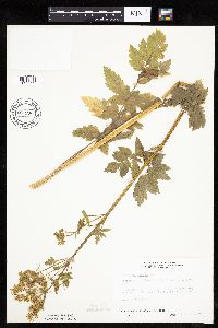 687296[1035522]Wheeler, Gerald; Glaser, Paul 17251977-06-27 United States, Minnesota, Itasca, Leech Lake Indian Reservation. Itasca Co.; coll. site no. 62; NE1/4 SE1/4 S26, T145N, R25W; Deer River, just adjacent to the Deer River Forestry Statio Itasca Co.; coll. site no. 62; NE1/4 SE1/4 S26, T145N, R25W; Deer River, just adjacent to the Deer River Forestry Station. 145N 25W 26, 47.346404 -93.8059 |
MIN:Plants | 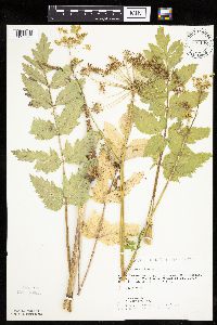 721146[1035566]Lustig, K. 7011979-07-11 United States, Minnesota, Sherburne, Clear Lake-Mississippi Scenic and Recreational River, SNA: 12 mi SE of St. Cloud, S14, 22, 23, T34N, R30W;Clear Lake Scientific Natural Area;034N;30W;, 45.446339 -94.043783 |
MIN:Plants | 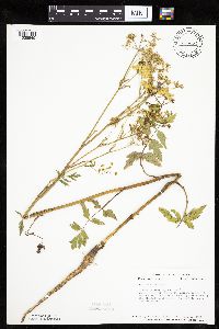 726454[1035540]Smith, Welby 28611980-07-17 United States, Minnesota, Mower, T104N, R14W, E1/2 S11; on the right-of-way of the Chicago and Northwestern RR tracks, ca 1/2 mi S of the Olmsted County T104N, R14W, E1/2 S11; on the right-of-way of the Chicago and Northwestern RR tracks, ca 1/2 mi S of the Olmsted County line. 104N 14W 11, 43.826853 -92.479096 |
MIN:Plants | 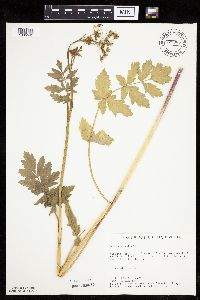 728987[1035542]Berlin, N. 831979-06-22 United States, Minnesota, Goodhue, Wacouta Pond Natural Area: 5 mi SE of Red Wing; portions of S6, T112N, R13W and S31, 32, T113N, R13W; Hwy #61 roadside;Wacouta Pond Natural Area, The Nature Conservancy;N;;, 44.550842 -92.383156 |
MIN:Plants |  735701[1035554]Benson, Douglas 1891981-07-09 United States, Minnesota, Wilkin, Foxhome Prairie: T133N, R45W, center SE1/4 NE1/4 S24, NW corner of grove;Foxhome Prairie, The Nature Conservancy;133N;45W;24, 46.318653 -96.290714 |
MIN:Plants |  738370[1035553]Galatowitsch, S. 3131982-06-22 United States, Minnesota, Goodhue, Grace Nature Preserve: T109N, R18W parts of NW1/4 SW1/4 and SW1/4 SW1/4 S8;Grace Nature Preserve, The Nature Conservancy;109N;18W;8, 44.262012 -93.010544 |
MIN:Plants |  739349[1035568]Sohmer, S. 20181968-06-16 United States, Minnesota, Houston, ca 3 mi S of Brownsdale on hwy 26;Dorer Memorial Hardwood State Forest;102N;04W;, 43.62916 -91.318526 |
MIN:Plants |  741398[1035537]Converse, C. 20691982-08-21 United States, Minnesota, Douglas, Staffanson Prairie: T127N, R40W NW1/4 NE1/4 and NE1/4 NW1/4 S18;Staffanson Prairie, The Nature Conservancy;127N;40W;18, 45.810665 -95.748005 |
MIN:Plants |  744997[1035539]Smith, Welby 44161981-06-24 United States, Minnesota, Mower, Wild Indigo Scientific Natural Area. Wild Indigo Scientific and Natural Area, ca 4 mi SW of the jnc of State Hwy 56 and Co Hwy 2 in Brownsdale, NE1/4 MW1/4 S Wild Indigo Scientific and Natural Area, ca 4 mi SW of the jnc of State Hwy 56 and Co Hwy 2 in Brownsdale, NE1/4 MW1/4 S24, T103N, R18W. 103N 18W 24, 43.710437 -92.939849 |
MIN:Plants |  745183[1035544]Smith, Welby 40851981-06-05 United States, Minnesota, Wright, Wright Co.; about 1/2 mi E of Howard on State Hwy 12, between the hwy and the Burlington Northern RR tracks, NE1/4 NE1/4 Wright Co.; about 1/2 mi E of Howard on State Hwy 12, between the hwy and the Burlington Northern RR tracks, NE1/4 NE1/4 S2, T118N, R27W. 118N 27W 2, 45.058248 -94.042965 |
MIN:Plants |  745304[1035546]Smith, Welby 45971981-06-30 United States, Minnesota, Steele, ca 1 1/2 mi ESE of Havana, between U.S. Hwy 14 and the Chicago and Northwestern RR tracks, NE1/4 SW1/4 S21, T107N, R19W;;107N;19W;21, 44.059162 -93.116148 |
MIN:Plants |  758742[1035521]Smith, Welby 63771982-06-15 United States, Minnesota, Mower, Racine Prairie Scientific Natural Area. Racine Prairie State Scientific and Natural Area, adjacent to the E side of US Trunk Hwy 63, ca 2 mi N of Racine; NE1/4 Racine Prairie State Scientific and Natural Area, adjacent to the E side of US Trunk Hwy 63, ca 2 mi N of Racine; NE1/4 NE1/4 S22, T104N, R14W. 104N 14W 22, 43.797643 -92.499267 |
MIN:Plants |  770786[1035543]Smith, Welby 81981983-07-03 United States, Minnesota, Wright, Wright Co.; S side of State Hwy 55, ca 2.7 mi NW of its jnc with Hwy 25 in Buffalo; NE1/4 NW1/4 S14, T120N, R26W;;120N;26W;14, 45.201156 -93.919616 |
MIN:Plants |  781267[1035538]Smith, Welby 92991984-06-23 United States, Minnesota, Mower, Cartney Wildlife Management Area. Cartney State Wildlife Management Area, ca 5 mi NNW of Le Roy, banks of the West Branch Little Iowa River, NE1/4 SE1/4 S Cartney State Wildlife Management Area, ca 5 mi NNW of Le Roy, banks of the West Branch Little Iowa River, NE1/4 SE1/4 S5, T101N, R14W. 101N 14W 5, 43.580048 -92.539234 |
MIN:Plants |  781943[1035517]Smith, Welby 93741984-06-27 United States, Minnesota, Jackson, Kilen Woods State Park, ca 8 mi NNW of Jackson, W side of the Des Moines River, NW1/4 NE1/4 S17, T103N, R35W;Kilen Woods State Park;103N;35W;17, 43.724814 -95.064648 |
MIN:Plants |  782718[1035520]Tenney, M. 2741982-06-29 United States, Minnesota, Winona, Whitewater State Park, Winona Co, T107N, R10W, S29, N1/4, SW1/4 NW1/4;Whitewater State Park;107N;10W;29, 44.042035 -92.049333 |
MIN:Plants |  833519[1035507]Juhnke, C. 0851991-06-05 United States, Minnesota, Fillmore, Forestville State Park. Fillmore Co. T102N R12W Sec.13 NE SW NE; N of restored prairie;Forestville State Park;102N;12W;13, 43.637724 -92.219269 |
MIN:Plants | 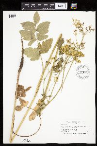 920882[1035541]Smith, Welby 257111995-07-03 United States, Minnesota, Scott, Minnesota Valley National Wildlife Refuge. Scott County...In the Louisville Swamp Area of the Minnesota Valley National Wildlife Refuge...T115N R23W SW1/4 of SW1/4 of Sec 28. 115N 23W 28, 44.7355556 -93.5988889 |
MIN:Plants | 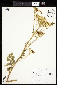 476957[1035559]Wheeler, Gerald 201191999-07-21 United States, Minnesota, Sibley, Sibley County ... Ca. 4.5 mi. NE of Gaylord on Rte. 5 ... N1/2 Sec. 19 T113N R27W (Arlington 19);;113N;27W;19, 44.57966 -94.12279 |
MIN:Plants |  905585[1035512]Gerdes, Lynden 41792000-08-02 United States, Minnesota, Lake, North Shore / Tettegouche State Park. T56N R08W S23SENE Lake County ... Tettegouche State Park, vicinity of Silver Bay ... Approximately 1.25 miles south of Lax Lake.. 056N 08W 23, 47.321895 -91.314488 |
MIN:Plants | 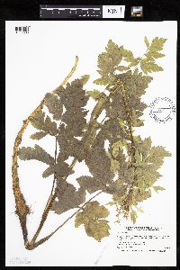 438666[1035505]Smith, Welby 168581990-06-18 United States, Minnesota, Waseca, Senn-Rich Wildlife Management Area. Waseca County...Senn-Rich State Wildlife Management Area, about 5 miles south of Waseca...T 106N R 22W SE1/4 of NW1/4 of Sec 8. 106N 22W 8, 44.002224 -93.4977798 |
MIN:Plants | 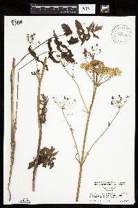 919342[1035533]Cholewa, A. 27572010-06-27 United States, Minnesota, Hennepin, Northwest corner of 129th Avenue N and County Road 13, east of Rogers. ;;120N;23W;24, 45.1886111 -93.5269444 |
MIN:Plants |  907763[1035536]Smith, Welby 31115A2008-08-13 United States, Minnesota, Le Sueur, Diamond Lake Wildlife Management Area. Le Sueur County ...Diamond Lake State Wildlife Management Area, about 0.5 mile north of Kilkenny ...T110N R23W SW1/4 of NE1/4 of Sec 22. 110N 23W 22, 44.3219444 -93.5719444 |
MIN:Plants |  933498[1122406]Smith, Welby R. 205311992-06-24 United States, Minnesota, Brown, On the south side of New Ulm in the Cottonwood River Valley NW of SE of section;Flandrau State Park;110N;30W;32, 44.2875 -94.4608333 |
MIN:Plants |  935986[1122401]Fetterer, Matt; Braun, Dave 12012-07-25 United States, Minnesota, Saint Louis, At intersection of US 53 and St. Louis County 22 near Sherman's Corner. On north side of St. Louis county 22 and east side of US 53. UTM: 525804E 5291855N. SE1/4 of section.;;061N;18W;08, 47.7795406 -92.6555458 |
MIN:Plants |  935978[1122405]Fetterer, Matt; Braun, Dave 102012-07-25 United States, Minnesota, Saint Louis, About 3 miles north of Ash Lake on US53. East side of road. UTM: 503866E 5346447N. NE1/4 of section.;Superior National Forest;067N;20W;30, 48.2712181 -92.9479003 |
MIN:Plants |  447734[1283575]Malinowski, Norma 212013-07-26 United States, Minnesota, Lake, about 2 mi E of Winton, MN and .5 mi W of Garden Lake bridge on Cty Rd 16. Mowed strip along Cty Rd.T63N R11W Section 20 SW1/4 NW1/4. [Superior National Forest], 47.9281913 -91.7688753 |
MIN:Plants |  942058[1283097]Smith, Welby R. 319662010-07-29 United States, Minnesota, Koochiching, Along Highway 30, about 6 miles west of Big Falls. NW of SE of section;;155N;26W;26, 48.2131032 -93.9355907 |
MIN:Plants |  962661[1346983]Graham, Dustin R. DRJG672016-07-14 United States, Minnesota, Marshall, Plants located three miles north of Holt, MN, between railroad and highway 32., 48.34 -96.19, 1142m |
MIN:Plants |  963563[1352178]Graham, Dustin R. DRJG1382018-06-20 United States, Minnesota, Otter Tail, 1.5 miles southeast of Davies, MN., 46.59 -95.28, 1400m |
MIN:Plants |  963630[1352245]Graham, Dustin R. DRJG1482018-08-02 United States, Minnesota, Otter Tail, 2.25 miles north of Little Pine Lake, MN, 46.68 -95.54, 1376m |
MIN:Plants |  963611[1352226]Graham, Dustin R. DRJG922017-07-21 United States, Minnesota, Douglas, Plans growing 2.6 miles west of Evansville, MN., 46 -95.74, 1342m |
MIN:Plants |  969852[1371440]C. Gernes s.n.2011-07-11 United States, Minnesota, Ramsey, Lower Afton Rd. and Winthrop St. So. Battle Creek Regional Park, 44.937485 -93.024393 |
1
Page 1, records 1-82 of 82
Google Map
Google Maps is a web mapping service provided by Google that features a map that users can pan (by dragging the mouse) and zoom (by using the mouse wheel). Collection points are displayed as colored markers that when clicked on, displays the full information for that collection. When multiple species are queried (separated by semi-colons), different colored markers denote each individual species.