University of Minnesota
http://www.umn.edu/
612-625-5000
http://www.umn.edu/
612-625-5000
Minnesota Biodiversity Atlas
Bell Museum
Dataset: MIN-Plants
Taxa: Rudbeckia
Search Criteria: excluding cultivated/captive occurrences
Bell Museum plants | |
 MIN:Plants |  349573[1050028]Engleman, J.; et al. 32951935-08-06 United States, Colorado, Devil's Gulch ... Rocky Mountain National Park;Rocky Mountain National Park, 2438m |
MIN:Plants |  476919[1050149]Wheeler, Gerald 174221997-08-29 United States, Minnesota, Renville, Renville County ... Ca. 2 mi. WSW of Morton on Rte. 51, N of road ... SE1/4 SE1/4 NE1/4 Sec. 26 T113N R35W;;113N;35W;26, 44.563483 -95.025051 |
MIN:Plants |  480766[1050031]Bosch, T. 262002-07-25 United States, Minnesota, Big Stone, Lac Qui Parle Wildlife Management Area. Big Stone County ... Lac Qui Parle Wildlife Area ... Approx. 0.5 east of Hwy. 75 and 2 miles south of Hwy. 7 ... T120N R45W sec. 1-2. 120N 45W 42371, 45.2325 -96.236536 |
MIN:Plants |  Rudbeckia occidentalis Nuttall 213370[1050155]Burglehaus, F. s.n.1893-08-00 United States, Wyoming, Park, Near Mammoth Hot Springs;Yellowstone National Park, 1829m |
MIN:Plants |  Rudbeckia hirta var. pulcherrima Farwell 524551[1050030]Benner, F.; Benner, J. 3551928-09-08 United States, Wisconsin, Polk, 7 mi. N. St. Croix Falls, on River Road;Saint Croix National Riverway;;;, 45.481172 -92.687024 |
MIN:Plants |  Rudbeckia californica A. Gray 232774[1049806]Congdon, J. s.n.1889-08-20 United States, California, Mariposa, Big Tree Grove, Mariposa County;Yosemite National Park;;;, 37.51 -119.60111 |
MIN:Plants |  488263[1050147]Juhnke, C. 131 CMJ FRO1998-09-24 United States, Minnesota, Goodhue, Frontenac State Park. Frontenac State Park Goodhue County ... Trail... between Hwy. 61 monument parking lot and Pleasant Valley Lakelet .. T112N R13W NW NE NE 14. 112N 13W 14, 44.505485 -92.339405 |
MIN:Plants |  Rudbeckia hirta var. pulcherrima Farwell 430233[1049944]DeMink, L. 3811999-08-20 United States, Minnesota, Morrison, Crane Meadows National Wildlife Refuge; SWSE 19-T40N-R31W;Crane Meadows National Wildlife Refuge;040N;31W;19, 45.948517 -94.251125 |
MIN:Plants | 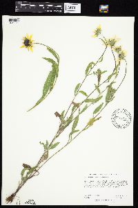 Rudbeckia hirta var. pulcherrima Farwell 910718[1050011]Rowe, Erika ERR2572007-06-28 United States, Minnesota, Hubbard, Paul Bunyan State Forest. Hubbard County...5 miles SSW of LaPorte; 1 mile east of State Hwy 64; 175m from south shore of Lester Lake...old farmstead)...T142N R32W NESE S06. 142N 32W 6, 47.1413889 -94.7702778 |
MIN:Plants | 410599[]Arboretum, Cary 7-24 United States, District of Columbia, Washington |
MIN:Plants | 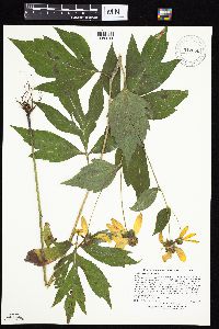 912680[1050041]Lee, Michael MDL45002007-08-07 United States, Minnesota, Wadena, Wadena County...Along the Leaf River ~1/4-mile southeast of the mouth of the Redeye River, ten miles north-northwest of downtown Staples...T135N R33W NW1/4 of NW!/4 Sec. 29...UTM: 5149447N 355569E. 135N 33W 29, 46.477394 -94.873359 |
MIN:Plants | 478548[]US Nat. Arboretum staff 84-411984-00-00 United States, Pennsylvania, York, York Co. |
MIN:Plants | 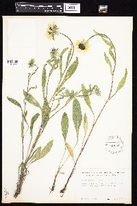 540032[1049991]Tester, John s.n.1957-07-03 United States, Minnesota, Mahnomen, 3-4 miles W and 1 mile S of Waubun;Waubun Prairie Wildlife Management Area / White Earth Indian Reservation;143N;42W;33, 47.1589 -96.00743 |
MIN:Plants | 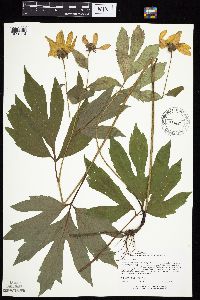 477581[1050113]Lee, Michael MDL14511996-08-06 United States, Minnesota, Benton, Benton County ... Six miles northwest of Milaca ... T38N R28W NW1/4 NE1/4 Sec. 13;;038N;28W;13, 45.78593 -93.772872 |
MIN:Plants | 478547[]US Nat. Arboretum staff 77-321977-00-00 United States, Maryland, Montgomery, Montgomery |
MIN:Plants | 426819[]US Nat. Arboretum staff 1974-451974-00-00 United States, District of Columbia, USNA [Nat. Arboretum] |
MIN:Plants | 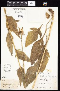 Rudbeckia californica A. Gray 232773[1049805]Congdon, J. s.n.1889-08-20 United States, California, Mariposa, Big Tree Grove, Mariposa County;Yosemite National Park;;;, 37.51 -119.60111 |
MIN:Plants | 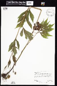 915850[1050040]Rowe, Erika ERR20060726082006-07-26 United States, Minnesota, Becker, Becker County...north edge of Buffalo River...NESE S17 T140N R43W;;140N;43W;17, 46.9416667 -96.1369444 |
MIN:Plants | 453058[1050164]Kaul, R. United States, Minnesota, Steele, Detailed locality information protected. This is typically done to protect rare or threatened species localities. |
MIN:Plants | 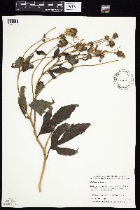 509045[1050090]Anderson, Craig 7591999-08-26 United States, Minnesota, Stevens, Stevens County ... Pasche Tract ... T123N R42W: SE 1/4 of NW 1/4 of SW 1/4 of sect. 20;;123N;42W;20, 45.448685 -95.963352 |
MIN:Plants | Rudbeckia hirta var. pulcherrima Farwell 608621[]Carter, R. 4851966-07-10 United States, California, Butte, 1 mi. S of Butte-Plumus [sic] Co. line along W side Oroville-Quincy Rd. ... Butte Co., 1372m |
MIN:Plants | 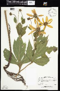 461606[1050101]Mortensen, Carol Estes LL10771995-08-02 United States, Minnesota, Cass, Leech Lake Reservation and Chippewa National Forest; SE shore of Bear Island; T142N, R29W, NESW12;Chippewa National Forest / Leech Lake Indian Reservation;142N;29W;12, 47.133376 -94.291795 |
MIN:Plants |  Rudbeckia occidentalis Nuttall 213374[1050156]Nelson, Aven; et al. 64081899-08-12 United States, Wyoming, Park, Snake River;Yellowstone National Park |
MIN:Plants |  Rudbeckia subtomentosa Pursh 482316[1050157]Bockenstedt, P. 010042001-08-26 United States, Minnesota, Mower, SE1/4, SE1/4, NE1/4, Sec. 14, T101 N, R18W, Mower County;;101N;18W;14, 43.550628 -92.959577 |
MIN:Plants |  911288[1050056]Smith, Welby 217771992-08-31 United States, Minnesota, Redwood, Redwood County...Alexander Ramsey Municipal Park in Redwood Falls...along the Redwood River...T 113N R 36W NW1/4 of SE1/4 of Sec 36. 113N 36W 36, 44.5480556 -95.1244444 |
MIN:Plants | 489297[1050159]Feikema, E. United States, Minnesota, Freeborn, Detailed locality information protected. This is typically done to protect rare or threatened species localities. |
MIN:Plants |  Rudbeckia occidentalis Nuttall 213369[1050154]Burglehaus, F. s.n.1893-08-00 United States, Wyoming, Park, Near Mammoth Hot Springs;Yellowstone National Park, 1829m |
MIN:Plants | 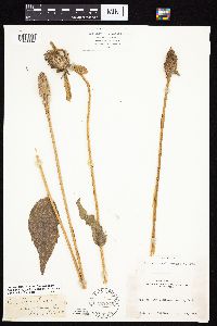 Rudbeckia californica A. Gray 232775[1049804]Congdon, J. s.n.1883-09-16 United States, California, Mariposa, Big Tree Grove, Mariposa County;Yosemite National Park;;;, 37.51 -119.60111 |
MIN:Plants | 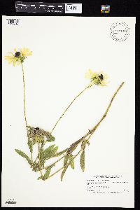 Rudbeckia hirta var. pulcherrima Farwell 911141[1050012]Smith, Welby 217531992-08-27 United States, Minnesota, Brown, Tauer Prairie Scientific Natural Area. Brown County...Tauer Prairie State Scientific and Natural Area, about 7 miles south-southwest of New Ulm...T 109N R 31W NW1/4 of SW1/4 of Sec 35. 109N 31W 35, 44.2013889 -94.5302778 |
MIN:Plants | 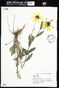 Rudbeckia hirta var. pulcherrima Farwell 438522[1050029]Quinn, Edward 42000-09-09 United States, Wisconsin, Saint Croix, Saint Croix National Riverway. St. Croix County ... Hudson, on the northeast corner of the intersection of Badlands Road and Bradley Drive...SE1/4 SE1/4 Section 23, T29N, R19W. 029N 19W 23, 44.985304 -92.649965 |
MIN:Plants | 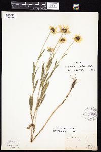 213283[1049941]Manning, Sara s.n.1883-07-18 United States, Minnesota, Wabasha, Lake City;;N;;, 44.449412 -92.266844 |
MIN:Plants | 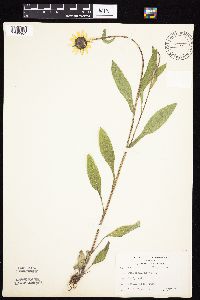 441338[1049904]Kukachka, B. 2881937-06-27 United States, Minnesota, Ramsey, Battle Creek Park;Battle Creek County Park;028N;22W;, 44.941407 -93.017474 |
MIN:Plants | 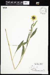 504924[1049811]Nation, R. 94-1051994-06-21 United States, Minnesota, Mower, Lake Louise State Park. Mower Co.; Tract #13N. T101N R14W NE1/4 of SE1/4 of Sec.21;Lake Louise State Park;101N;14W;21, 43.536578 -92.519043 |
MIN:Plants | 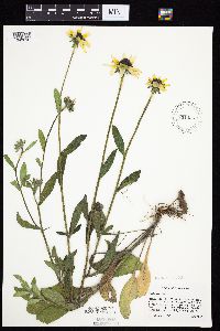 Rudbeckia hirta var. pulcherrima Farwell 831056[1049816]Cholewa, A. 20471992-06-00 United States, Minnesota, Aitkin, Hwy.65 at Snake River, canoe access on co.rd.61,.;;044N;23W;32, 46.252863 -93.272161 |
MIN:Plants | 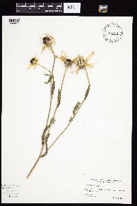 Rudbeckia hirta var. pulcherrima Farwell 831434[1049857]Cloutier, H. s.n.1943-07-28 United States, Minnesota, Itasca, Coleraine, Trout Lake vicinity;;055N;24W;, 47.281172 -93.425501 |
MIN:Plants | 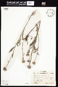 Rudbeckia hirta var. pulcherrima Farwell 832461[1049856]Benson, Robert 1791941-08-25 United States, Minnesota, Saint Louis, Near Biwabik ;;058N;16W;, 47.502156 -92.369137 |
MIN:Plants | 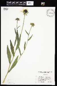 Rudbeckia hirta var. pulcherrima Farwell 839331[1049817]Cholewa, A. 23141995-07-06 United States, Minnesota, Aitkin, About 17 mi NE of McGregor, old homesite on NW end of Wolf Lake. NE1/4 of section;Savanna Portage State Park;050N;22W;06, 46.8467 -93.174446 |
MIN:Plants | 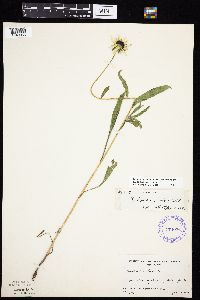 Rudbeckia hirta var. pulcherrima Farwell 174076[1049956]Linnaean Club, U of M, 3081943-07-10 United States, Minnesota, Rice, Nerstrand Woods. Rice Co. Below falls;Nerstrand Woods State Park;110N;19W;, 44.327064 -93.100886 |
MIN:Plants | 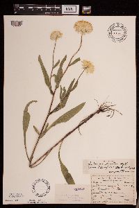 Rudbeckia hirta var. pulcherrima Farwell 213147[1289361]Sandberg, John s.n.1890-07-00 United States, Minnesota, Hennepin, [no further data];;;;, 45 -93.47 |
MIN:Plants |  Rudbeckia hirta var. pulcherrima Farwell 213220[1049877]Ballard, C. 25601900-08-00 United States, Minnesota, Kittson, St. Vincent;;163N;51W;, 48.970241 -97.226709 |
MIN:Plants |  Rudbeckia hirta var. pulcherrima Farwell 213263[1049926]Wheeler, William 6131899-08-25 United States, Minnesota, Houston, Brownsville, Houston Co.;;103N;04W;, 43.695398 -91.283479 |
MIN:Plants |  Rudbeckia hirta var. pulcherrima Farwell 213264[1050008]Wheeler, William 3011899-07-07 United States, Minnesota, Houston, Crooked Creek, Houston Co.;Dorer Memorial Hardwood State Forest;N;;, 43.62916 -91.318526 |
MIN:Plants |  Rudbeckia hirta var. pulcherrima Farwell 213265[1049863]Leonard, W. s.n.1875-08-00 United States, Minnesota, Hennepin, Minneapolis;;N;;, 44.979965 -93.263836 |
MIN:Plants | 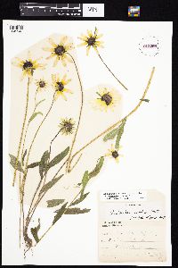 Rudbeckia hirta var. pulcherrima Farwell 213266[1049946]C., S. s.n.1890-07-08 United States, Minnesota, Washington, Stillwater;;030N;21W;, 45.079652 -92.9239 |
MIN:Plants | 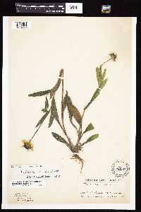 Rudbeckia hirta var. pulcherrima Farwell 213267[1049920]Ainslie, G. 38851902-06-26 United States, Minnesota, Olmsted, Rochester;;106N;14W;, 43.97834 -92.49834 |
MIN:Plants | 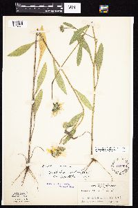 Rudbeckia hirta var. pulcherrima Farwell 213268[1049924]Rosendahl, C. 6531902-06-30 United States, Minnesota, Houston, Spring Grove;;101N;07W;, 43.543923 -91.6707 |
MIN:Plants | 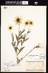 Rudbeckia hirta var. pulcherrima Farwell 213269[1049895]Campbell, Jennie s.n.1897-07-00 United States, Minnesota, Otter Tail, Clitherall;;N;;, 46.275077 -95.635853 |
MIN:Plants | 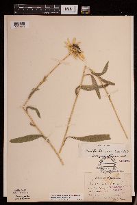 Rudbeckia hirta var. pulcherrima Farwell 213270[1289353]Sandberg, John s.n.1886-07-00 United States, Minnesota, Goodhue, [no further data];;;;, 44.40976099 -92.72282341 |
MIN:Plants | 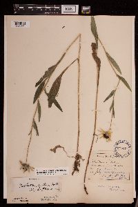 Rudbeckia hirta var. pulcherrima Farwell 213271[1289354]Aiton, George B. s.n.1889-07-15 United States, Minnesota, Hennepin, [no further data];;;;, 45 -93.47 |
MIN:Plants | 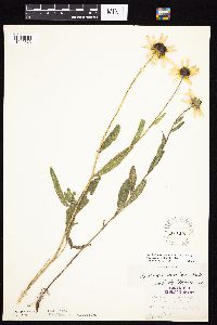 Rudbeckia hirta var. pulcherrima Farwell 213272[1049873]Herrick, C. 80-41876-07-20 United States, Minnesota, Hennepin, Minneapolis;;N;;, 44.979965 -93.263836 |
MIN:Plants | 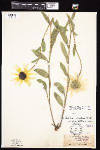 Rudbeckia hirta var. pulcherrima Farwell 213273[1049981]Sandberg, John s.n.1882-07-00 United States, Minnesota, Goodhue, Cannon Falls;;112N;17W;18, 44.507071 -92.90512 |
MIN:Plants | 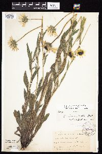 Rudbeckia hirta var. pulcherrima Farwell 213274[1049903]Taylor, B. T5741891-06-00 United States, Minnesota, Blue Earth, Minnesota Lake;;N;;, 43.837621 -93.860827 |
MIN:Plants | 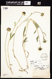 Rudbeckia hirta var. pulcherrima Farwell 213275[1049854]Arthur, J.; et al. B3031886-07-23 United States, Minnesota, Saint Louis, [no data given but nearly all of their collections were from St. Louis Co.];;;;, 47.589862 -92.461466 |
MIN:Plants | 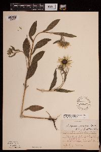 Rudbeckia hirta var. pulcherrima Farwell 213276[1289351]Huntington, A. E. s.n.1890-07-04 United States, Minnesota, Rock, Rock Co.;;;;, 43.67 -96.25 |
MIN:Plants | 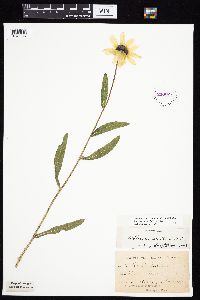 Rudbeckia hirta var. pulcherrima Farwell 213277[1049947]Kassube, J. s.n.1878-06-00 United States, Minnesota, Hennepin, Minneapolis;;N;;, 44.979965 -93.263836 |
MIN:Plants |  Rudbeckia hirta var. pulcherrima Farwell 213278[1049983]Goldsmith, G. G.1601912-00-00 United States, Minnesota, Rice, Northfield;;N;;, 44.458298 -93.161604 |
MIN:Plants |  Rudbeckia hirta var. pulcherrima Farwell 213279[1049992]Rosendahl, C. 22551909-07-10 United States, Minnesota, Snelling Reservation [old regional park spanning junction of Minnesota and Mississippi rivers];;028N;23W;, 44.90516 -93.16646 |
MIN:Plants |  Rudbeckia hirta var. pulcherrima Farwell 213280[1049821]Moyer, Lycurgus s.n.1906-08-05 United States, Minnesota, Otter Tail, Leaf Hills;;;;, 46.144254 -95.573544 |
MIN:Plants |  Rudbeckia hirta var. pulcherrima Farwell 213281[1289356]Aiton, George B. 55-491890-09-00 United States, Minnesota, Chippewa, Chippewa Co.;;;;, 45.099837 -95.612185 |
MIN:Plants |  Rudbeckia hirta var. pulcherrima Farwell 213282[1289349]Moyer, Lycurgus R. s.n.1897-06-25 United States, Minnesota, Hennepin, [no further data];;;;, 45 -93.47 |
MIN:Plants |  Rudbeckia hirta var. pulcherrima Farwell 213284[1049940]Aiton, G. s.n.1890-08-00 United States, Minnesota, Hennepin, Near Minneapolis;;N;;, 44.979965 -93.263836 |
MIN:Plants |  Rudbeckia hirta var. pulcherrima Farwell 213285[1049843]Ballard, C. B10561892-07-00 United States, Minnesota, Nicollet, Courtland, Nicollet Co.;;109N;29W;, 44.239382 -94.311376 |
MIN:Plants |  Rudbeckia hirta var. pulcherrima Farwell 213286[1289359]Sandberg, John s.n.1889-08-00 United States, Minnesota, Hennepin, [no further data];;;;, 45 -93.47 |
MIN:Plants |  Rudbeckia hirta var. pulcherrima Farwell 213287[1050001]Ballard, C. B15691893-07-00 United States, Minnesota, Cass, Upper Gull Lake. Cass Co.;;135N;29W;, 46.500163 -94.32908 |
MIN:Plants |  Rudbeckia hirta var. pulcherrima Farwell 213288[1049969]Sheldon, Edmund s.n.1895-06-00 United States, Minnesota, Hennepin, Ft. Snelling;Fort Snelling Military Reservation;N;;, 44.905162 -93.166462 |
MIN:Plants |  Rudbeckia hirta var. pulcherrima Farwell 213289[1049952]Taylor, B. T7901891-07-00 United States, Minnesota, Pope, Glenwood;;N;;, 45.650239 -95.389758 |
MIN:Plants |  Rudbeckia hirta var. pulcherrima Farwell 213291[1049999]Rosendahl, C. 2091901-08-00 United States, Minnesota, Houston, Spring Grove;;101N;07W;, 43.543923 -91.6707 |
MIN:Plants |  Rudbeckia hirta var. pulcherrima Farwell 213292[1050005]MacMillan, C.; et al. 41Sk1900-08-00 United States, Minnesota, Polk, Crookston;;150N;46W;30, 47.77414 -96.60812 |
MIN:Plants |  Rudbeckia hirta var. pulcherrima Farwell 213293[1049865]Sheldon, Edmund S29511892-07-00 United States, Minnesota, Mille Lacs, Milaca;;N;;, 45.755799 -93.654408 |
MIN:Plants |  Rudbeckia hirta var. pulcherrima Farwell 213294[1049874]Taylor, B. T14031892-07-00 United States, Minnesota, Chisago, Center City;;N;;, 45.42608 -92.83619 |
MIN:Plants |  Rudbeckia hirta var. pulcherrima Farwell 213295[1049864]Frost, W. F2401892-07-00 United States, Minnesota, Kandiyohi, Willmar;;N;;, 45.110139 -95.062995 |
MIN:Plants | 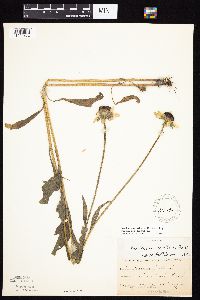 Rudbeckia hirta var. pulcherrima Farwell 213296[1049862]Lugger, O. s.n.1891-08-00 United States, Minnesota, Ramsey, St. Anthony Park [St. Paul neighborhood near U of M];;029N;23W;, 44.992077 -93.166387 |
MIN:Plants | 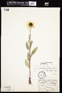 Rudbeckia hirta var. pulcherrima Farwell 213297[1050002]Menzel, Max s.n.1895-07-00 United States, Minnesota, Pipestone, Pipestone [assuming the quarry area; town generally noted as "Pipestone City" by collector];Pipestone National Monument;106N;46W;01, 44.01585 -96.31767 |
MIN:Plants | 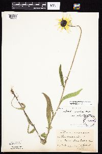 Rudbeckia hirta var. pulcherrima Farwell 213298[1049872]Ballard, C. B4661891-07-00 United States, Minnesota, Scott, Prior Lake;;N;;, 44.713297 -93.422727 |
MIN:Plants | 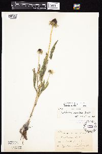 Rudbeckia hirta var. pulcherrima Farwell 213299[1050000]Sheldon, Edmund S12751891-08-00 United States, Minnesota, Lincoln, Lake Benton;;109N;45W;, 44.24108 -96.26172 |
MIN:Plants |  Rudbeckia hirta var. pulcherrima Farwell 213300[1049960]Sheldon, Edmund S13581891-08-00 United States, Minnesota, Lincoln, Lake Benton;;109N;45W;, 44.24108 -96.26172 |
MIN:Plants |  Rudbeckia hirta var. pulcherrima Farwell 213301[1049852]Taylor, B. T4781891-06-00 United States, Minnesota, Waseca, Mud Lake;;N;;, 43.8899 -93.416 |
MIN:Plants |  Rudbeckia hirta var. pulcherrima Farwell 213302[1049917]Taylor, B. T7901891-07-00 United States, Minnesota, Pope, Glenwood;;N;;, 45.650239 -95.389758 |
MIN:Plants |  Rudbeckia hirta var. pulcherrima Farwell 213303[1049879]Ballard, C. B1211891-06-00 United States, Minnesota, Carver, Chaska;;N;;, 44.789407 -93.602179 |
MIN:Plants | 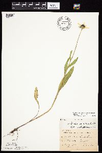 Rudbeckia hirta var. pulcherrima Farwell 213304[1049880]Sheldon, Edmund S31231892-07-00 United States, Minnesota, Mille Lacs, Princeton;;N;;, 45.569965 -93.581628 |
MIN:Plants | 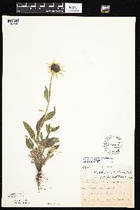 Rudbeckia hirta var. pulcherrima Farwell 213305[1049896]Ballard, C. B2711891-06-00 United States, Minnesota, Scott, Jordan, Scott Co.;;114N;23W;, 44.674435 -93.582701 |
MIN:Plants | 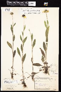 Rudbeckia hirta var. pulcherrima Farwell 213306[1050007]Sheldon, Edmund S29041892-07-00 United States, Minnesota, Kanabec, Mora, Kanabec Co.;;039N;24W;, 45.860683 -93.327529 |
MIN:Plants | 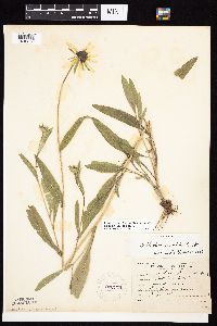 Rudbeckia hirta var. pulcherrima Farwell 222179[1049853]Roberts, Thomas s.n.1904-07-00 United States, Minnesota, Wabasha, Brook Lodge;;N;;, 44.28 -92.24 |
MIN:Plants | 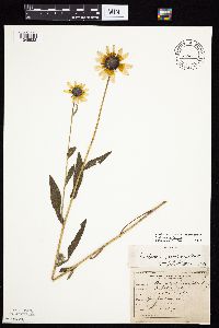 Rudbeckia hirta var. pulcherrima Farwell 222186[1049938]Roberts, Thomas s.n.1904-07-16 United States, Minnesota, Wabasha, Brook Lodge;;N;;, 44.28 -92.24 |
MIN:Plants | 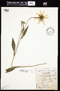 Rudbeckia hirta var. pulcherrima Farwell 222189[1049939]Roberts, Thomas s.n.1904-07-16 United States, Minnesota, Wabasha, Brook Lodge.;;N;;, 44.28 -92.24 |
MIN:Plants | 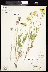 Rudbeckia hirta var. pulcherrima Farwell 222458[1049898]Stork, H. s.n.1925-00-00 United States, Minnesota, Itasca, Bowstring;Chippewa National Forest;;;, 47.54306 -93.79639 |
MIN:Plants | 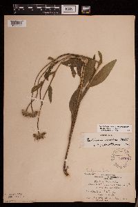 Rudbeckia hirta var. pulcherrima Farwell 224004[1289355]Holzinger, John s.n.1905-08-00 United States, Minnesota, Winona, Winona Co.;;N;;, 43.997785 -91.748027 |
MIN:Plants |  Rudbeckia hirta var. pulcherrima Farwell 224014[1289358]Holzinger, John s.n.1905-08-00 United States, Minnesota, Winona, Winona Co.;;N;;, 43.997785 -91.748027 |
MIN:Plants |  Rudbeckia hirta var. pulcherrima Farwell 270059[1049964]Wheeler, William 581893-06-20 United States, Minnesota, Houston, Winnebago Valley;Dorer Memorial Hardwood State Forest;N;;, 43.630682 -91.431985 |
MIN:Plants |  Rudbeckia hirta var. pulcherrima Farwell 275877[1049937]Grant, Martin 30391929-08-08 United States, Minnesota, Clearwater, Itasca Park. Source of Mississippi. NW-SW 35 T144 R36;Itasca State Park;144N;36W;35, 47.246503 -95.201577 |
MIN:Plants |  Rudbeckia hirta var. pulcherrima Farwell 276953[1050006]Huff, N. 1261914-07-09 United States, Minnesota, Lake, North Kawishiwi Riv.;Superior National Forest;N;;, 47.932465 -91.492465 |
MIN:Plants | 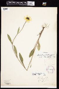 Rudbeckia hirta var. pulcherrima Farwell 277806[1049994]Roberts, Thomas s.n.1887-06-28 United States, Minnesota, Hennepin, Minneapolis;;N;;, 44.979965 -93.263836 |
MIN:Plants | 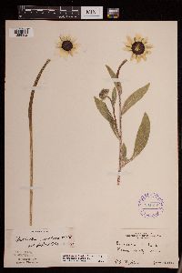 Rudbeckia hirta var. pulcherrima Farwell 291835[1289352]Fryklund, P. O. s.n.1925-06-28 United States, Minnesota, Roseau, Roseau Co.;;;;, 48.775139 -95.810817 |
MIN:Plants | 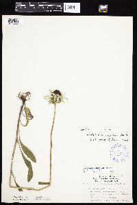 Rudbeckia hirta var. pulcherrima Farwell 347275[1049993]Lakela, Olga 20911937-07-29 United States, Minnesota, Saint Louis, St. Louis Ave. at 9th Street. Duluth.;;N;;, 46.783273 -92.106579 |
MIN:Plants | 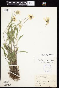 Rudbeckia hirta var. pulcherrima Farwell 349007[1049921]Nielsen, E. 111928-07-16 United States, Minnesota, Beltrami, Camp Wanaki, Cass Lake;Leech Lake Indian Reservation;N;;, 47.407009 -94.552998 |
MIN:Plants | 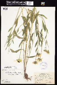 Rudbeckia hirta var. pulcherrima Farwell 352298[1049950]Lakela, Olga 20431937-07-11 United States, Minnesota, Saint Louis, S of Hunter's Hill, Duluth;;N;;, 46.83231 -92.08242 |
MIN:Plants | 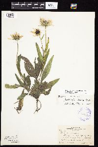 Rudbeckia hirta var. pulcherrima Farwell 352434[1049832]Nielsen, E. 17221932-09-18 United States, Minnesota, Scott, Along railroad right of way, 1 mi W of village of Savage;;115N;21W;, 44.753605 -93.344349 |
MIN:Plants | 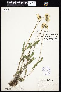 Rudbeckia hirta var. pulcherrima Farwell 352633[1049818]Nielsen, E. 401927-08-02 United States, Minnesota, Chisago, 3 1/2 mi N of Chisago City;;N;;, 45.424257 -92.889938 |
MIN:Plants | 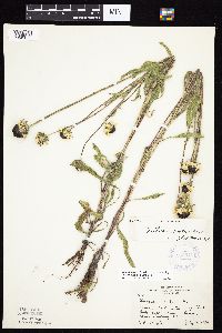 Rudbeckia hirta var. pulcherrima Farwell 353511[1049850]Moyle, J. 13401934-07-18 United States, Minnesota, Pennington, 24.5 mi S of Thief River Falls. Along Hwy.22.;;N;;, 48.137191 -96.175395 |
MIN:Plants |  Rudbeckia hirta var. pulcherrima Farwell 354026[1049923]Lakela, Olga 26101938-07-29 United States, Minnesota, Saint Louis, Hwy. #4, Palo;;057N;15W;, 47.415324 -92.239713 |
Google Map
Google Maps is a web mapping service provided by Google that features a map that users can pan (by dragging the mouse) and zoom (by using the mouse wheel). Collection points are displayed as colored markers that when clicked on, displays the full information for that collection. When multiple species are queried (separated by semi-colons), different colored markers denote each individual species.