University of Minnesota
http://www.umn.edu/
612-625-5000
http://www.umn.edu/
612-625-5000
Minnesota Biodiversity Atlas
Bell Museum
Dataset: MIN-Plants
Taxa: Sanicula
Search Criteria: excluding cultivated/captive occurrences
Bell Museum plants | |
 MIN:Plants |  913680[1035866]Smith, Welby 244091994-06-17 United States, Minnesota, Anoka, Rum River County Park. Anoka County... On the west bank of the Rum River, in Rum River Central Regional Park... T32N R24W NW1/4 of SE1/4 of Sec 6.. 032N 24W 6, 45.29 -93.3741667 |
MIN:Plants |  909206[1035603]Smith, Welby 220441992-09-27 United States, Minnesota, Goodhue, Goodhue County ... Frontenac State Park, about 2 miles north-northeast of Frontenac...T112N R13W NW1/4 of SE1/4 of Sec 2;Frontenac State Park;112N;13W;02, 44.5341667 -92.335 |
MIN:Plants |  920329[1035633]Smith, Welby 240351993-09-30 United States, Minnesota, Fillmore, Fillmore County ... About 5 miles south of Pilot Mound ... T103N R10W NE1/4 of SW1/4 of Sec 2;Dorer Memorial Hardwood State Forest;103N;10W;02, 43.7508333 -92.0175 |
MIN:Plants |  909814[1035865]Smith, Welby 246091994-07-11 United States, Minnesota, Koochiching, Koochiching County...About 3 mi east of Northome...south side of Tuefer Lake...T151N R28W SW1/4 of NE1/4 of Sec 27;;151N;28W;27, 47.8694444 -94.2183333 |
MIN:Plants |  Sanicula gregaria E.P. Bicknell 912112[1035655]Smith, Welby 230551993-07-21 United States, Minnesota, Meeker, Meeker County... On the south side of T.H. 12; about 2 miles southeast of Darwin... T119N R30W NW1/4 of SE1/4 of Sec 25;;119N;30W;25, 45.0872222 -94.3916667 |
MIN:Plants |  911854[1035605]Smith, Welby 219651992-09-07 United States, Minnesota, Watonwan, Eagle Nest County Park. Watonwan County...In Eagle Nest County Park, about 5 miles east of St. James...along the South Fork Watonwan River... T 106N R 31W NE1/4 of NE1/4 of Sec 14. 106N 31W 14, 43.9925 -94.5097222 |
MIN:Plants |  911805[1035604]Smith, Welby 218951992-09-03 United States, Minnesota, Watonwan, Watonwan County...About 5 miles east of St. James...along the South Fork Watonwan River...T 106N R 31W SW1/4 of SE1/4 of Sec 14. 106N 31W 14, 43.9786111 -94.5255556 |
MIN:Plants |  Sanicula gregaria E.P. Bicknell 913940[1035656]Smith, Welby 227901993-07-09 United States, Minnesota, Rock, Blue Mounds State Park. Rock County ... Blue Mounds State Park, about 4 miles north-northeast of Luverne...Mound Creek. T 103N R 45W NW 1/4 of NW 1/4 of Sec 24. 103N 45W 24, 43.7163889 -96.1897222 |
MIN:Plants |  Sanicula gregaria E.P. Bicknell 919166[1035657]Anderson, Derek 9222008-06-12 United States, Minnesota, Waseca, Waseca County ... Ca. 8.5 km northeast of Janesville on.[sic] Along Iosco Creek, just off of County Road 5 ... T108N, R23W, NWSE 07. 108N 23W 7, 44.1738889 -93.6375 |
MIN:Plants |  Sanicula gregaria E.P. Bicknell 910980[1035643]Smith, Welby 244911994-06-27 United States, Minnesota, Stearns, Stearns County... In Birch Lake State Forest, about 4 miles south of Grey Eagle... T127N R33W NE1/4 of NE1/4 of Sec 36;Birch Lakes State Forest;127N;33W;36, 45.7730556 -94.7705556 |
MIN:Plants |  435659[1035908]Schik, K. 95-831995-08-18 United States, Minnesota, Norman, Norman Co, T144N R43W SW1/4 of the NW1/4 of S26; at Faith Wildlife Management Area.;Faith Wildlife Management Area;144N;43W;26, 47.260347 -96.098789 |
MIN:Plants |  916914[1035836]Smith, Welby 224521993-06-18 United States, Minnesota, Grant, Grant County ... South side of Ask Lake, about 1.5 miles east-southeast of Ashby ... T130N R41W NW1/4 of SW1/4 of Sec 12;;130N;41W;12, 46.0847222 -95.7886111 |
MIN:Plants |  484671[1035917]Kaul, R.; et al. 64401989-06-21 United States, Minnesota, Clearwater, Clearwater County...Itasca Park.;Itasca State Park;143N;36W;00, 47.19557 -95.233216 |
MIN:Plants |  435620[1035909]Nation, R. 94-0871994-06-08 United States, Minnesota, Mower, Lake Louise State Park. Mower Co.; Tract #3A. T101N R14W NW1/4 of SW1/4 of Sec. 21;Lake Louise State Park;101N;14W;21, 43.53658 -92.51904 |
MIN:Plants | Sanicula trifoliata E.P. Bicknell 472655[1035979]Lee, Michael United States, Minnesota, Wabasha, Detailed locality information protected. This is typically done to protect rare or threatened species localities. |
MIN:Plants |  427951[1035918]Kaul, R. 64921989-06-28 United States, Minnesota, Clearwater, Clearwater County...along the north boundary road of Itasca Park.;Itasca State Park;143N;36W;00, 47.19557 -95.233216 |
MIN:Plants |  919367[1035630]Chayka, K. KC-10102010-06-17 United States, Minnesota, Ramsey, Ramsey County...Long Lake County Park; woods north of the swimming beach...between paved trail and shore of Long Lake;Long Lake County Park;;;, 45.0777778 -93.2002778 |
MIN:Plants |  911778[1035607]Smith, Welby 252641994-08-23 United States, Minnesota, Carver, Carver County...Minnesota Valley State Park, about 1.5 miles NNE of Belle Plain...T 114N R 24W SW1/4 of SE1/4 of Sec 30;Minnesota Valley State Park;114N;24W;30, 44.6458333 -93.7541667 |
MIN:Plants |  Sanicula gregaria E.P. Bicknell 911166[1035654]Smith, Welby 218561992-09-03 United States, Minnesota, Watonwan, Watonwan County...At the public access on the north side of Fedji Lake, about 2 miles northeast of Madelia...T 107N R 30W SW1/4 of SW1/4 of Sec 12. 107N 30W 12, 44.0816667 -94.3880556 |
MIN:Plants |  915018[1035916]Smith, Welby 226421993-07-01 United States, Minnesota, Otter Tail, Inspiration Peak Scenic Wayside Park. Otter Tail County...Inspiration Peak State Wayside Park, about 12 miles west of Parkers Prairie...T131N R39W SE1/4 of SW1/4 of Sec 22. 131N 39W 22, 46.1383333 -95.5736111 |
MIN:Plants |  907687[1035602]Smith, Welby 311262008-08-14 United States, Minnesota, Le Sueur, Le Sueur County...at the north end of Lake Pepin, about 2 mi N-NW of Montgomery...T112N R23W NW1/4 of NW1/4 of Sec 33;;112N;23W;33, 44.4691667 -93.6019444 |
MIN:Plants |  493277[1035901]Juhnke, C. 516 CMJ FRO1999-08-10 United States, Minnesota, Goodhue, Frontenac State Park. Goodhue County ... at quarry along self-guided trail ... T112N R13W NE NW SE 2;Frontenac State Park;112N;13W;02, 44.535072 -92.339158 |
MIN:Plants | Sanicula trifoliata E.P. Bicknell 472954[1035980]Lee, Michael United States, Minnesota, Stearns, Detailed locality information protected. This is typically done to protect rare or threatened species localities. |
MIN:Plants |  Sanicula gregaria E.P. Bicknell 454515[1035658]Biederman, L. 0091997-07-09 United States, Minnesota, Rice, Rice County ... Nerstrand Big Woods State Park ... T110N R19W 09;Nerstrand Woods State Park;110N;19W;09, 44.348871 -93.111081 |
MIN:Plants |  Sanicula gregaria E.P. Bicknell 912128[1035726]Smith, Welby 228511993-07-14 United States, Minnesota, Sibley, Vale Wildlife Management Area. Sibley County...Vale State Wildlife Management Area, ca 2.5 miles N-NW of Henderson; in the valley of High Island Creek, ca 2.5 miles SW of its confluence with the Minn R...T 113N R 26W NE1/4 of SW1/4 of Sec 27. 113N 26W 27, 44.5625 -93.9427778 |
MIN:Plants |  435199[1035910]Nation, R. 94-1061994-06-21 United States, Minnesota, Mower, Lake Louise State Park. Mower Co.; Tract #13N. T101N R14W NE1/4 of SE1/4 of Sec. 21;Lake Louise State Park;101N;14W;21, 43.53658 -92.51904 |
MIN:Plants |  164933[1035609]Lyon, H. 2601899-07-20 United States, Minnesota, Houston, Jefferson;Dorer Memorial Hardwood State Forest;101N;04W;35, 43.50806 -91.28287 |
MIN:Plants |  164934[1035589]Sheldon, Edmund S9831891-07-00 United States, Minnesota, Brown, Cross Lake;;N;;, 44.226064 -94.744719 |
MIN:Plants | Sanicula trifoliata E.P. Bicknell 472637[1035978]Lee, Michael United States, Minnesota, Morrison, Detailed locality information protected. This is typically done to protect rare or threatened species localities. |
MIN:Plants |  369835[1035588]Moore, John; et al. 146211941-07-05 United States, Minnesota, Wright, 1 mi NW of Annandale. Wright Co.;;;;, 45.272981 -94.138975 |
MIN:Plants |  385720[1035596]Rosendahl, C. 77011944-07-17 United States, Minnesota, Houston, near NE corner of S22, Spring Grove Twp;;101N;07W;22, 43.536807 -91.660825 |
MIN:Plants | 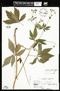 434856[1035580]Kern, Carole; et al. 21121993-07-21 United States, Minnesota, Houston, Houston County...MCBS #3. Location: T-104-N R-07-W Sec. 26 SE4 SW4;Dorer Memorial Hardwood State Forest;104N;07W;26, 43.781706 -91.640916 |
MIN:Plants | 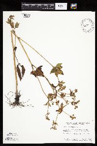 440536[1035593]Smith, Welby 149501988-08-23 United States, Minnesota, Houston, Houston Co. About 1 mi E of Rushford; SE1/4 NE1/4 sec.18, T104N R7W;Dorer Memorial Hardwood State Forest;104N;07W;18, 43.810366 -91.720423 |
MIN:Plants | 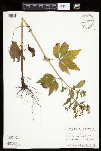 440689[1035629]Smith, Welby 149341988-08-23 United States, Minnesota, Houston, Houston Co. About 4 mi E-SE of Rushford; SW1/4 NW1/4 sec.27, T104N R7W;;104N;07W;27, 43.781685 -91.660731 |
MIN:Plants | 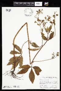 440910[1035594]Smith, Welby 149231988-08-20 United States, Minnesota, Fillmore, Fillmore Co. About 2 mi N of Peterson; ravine that drains SE into the Root River. NW14/ NW1/4 sec.17, T104N R8W;;104N;08W;17, 43.810676 -91.820145 |
MIN:Plants | 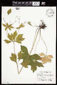 447428[1035600]Dunevitz, H. 8881993-09-30 United States, Minnesota, Wabasha, Dorer Memorial Hardwood State Forest. Wabasha Co.; 3/4 mile south and east of Theilman on bluff on west side of West Indian Creek; T 109 R 11 NE1/4 of NW1/4 o Wabasha Co.; 3/4 mile south and east of Theilman on bluff on west side of West Indian Creek; T 109 R 11 NE1/4 of NW1/4 of Sec 6. 109N 11W 6, 44.273126 -92.179589 |
MIN:Plants | 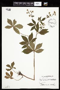 447432[1035598]Dunevitz, H. 9171993-07-21 United States, Minnesota, Winona, Winona Co.; Winona, on bluff just east of St. Mary's College, above housing development; T 107 R 7 SW1/4 of NE1/4 of sec Winona Co.; Winona, on bluff just east of St. Mary's College, above housing development; T 107 R 7 SW1/4 of NE1/4 of sec 29. 107N 07W 29, 44.041503 -91.690125 |
MIN:Plants | 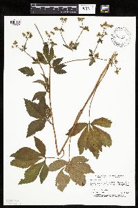 448260[1035624]Dunevitz, H. 9091993-08-17 United States, Minnesota, Winona, Dorer Memorial Hardwood State Forest. Winona Co.; Goodview, on south-facing bluff west of Highway 61, adjacent to Bronk tract in R.J. Dorer State Forest; T 10 Winona Co.; Goodview, on south-facing bluff west of Highway 61, adjacent to Bronk tract in R.J. Dorer State Forest; T 107 R 8 NE1/4 of SE1/4 of sec 24. 107N 08W 24, 44.05599 -91.730291 |
MIN:Plants | 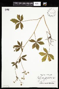 448261[1035623]Dunevitz, H. 9141993-08-20 United States, Minnesota, Winona, Dorer Memorial Hardwood State Forest. Winona Co.; Two miles north of Rushford on south to west facing bluff just north of County Road 4; T 105 R 7 NW1/4 of SE Winona Co.; Two miles north of Rushford on south to west facing bluff just north of County Road 4; T 105 R 7 NW1/4 of SE1/4 of Sec 19. 105N 07W 19, 43.882829 -91.709791 |
MIN:Plants |  448265[1035599]Dunevitz, H. 9321993-07-19 United States, Minnesota, Winona, Dorer Memorial Hardwood State Forest. Winona Co.; About 1 mile south and west of Lamoille, on south-facing bluff above County Road 7; T 106 R 6 SE1/4 of SE1/4 Winona Co.; About 1 mile south and west of Lamoille, on south-facing bluff above County Road 7; T 106 R 6 SE1/4 of SE1/4 of Sec 12. 106N 06W 12, 43.998451 -91.490398 |
MIN:Plants |  455930[1035584]Kern, Carole 21871993-08-18 United States, Minnesota, Houston, Houston County...MCBS #019. Location: T-103-N R-7-W SEC.14 SW4 SW4;Dorer Memorial Hardwood State Forest;103N;07W;14, 43.724005 -91.640757 |
MIN:Plants |  456560[1035579]Harris, Fred 950681995-08-09 United States, Minnesota, Scott, Minnesota Valley State Park. Scott County...Carver Rapids Wayside, Minnesota Valley State Recreation Area...Minnesota river valley on island just southeast of Louisville swamp...T 115 R 23 NE1/4 of SW1/4 of Sec 32. 115N 23W 32, 44.725535 -93.612653 |
MIN:Plants |  464601[1035592]Dunevitz, H. 11111994-06-23 United States, Minnesota, Wabasha, Dorer Memorial Hardwood State Forest. Wabasha County...R.J. Dorer State Forest, in Zumbro Bottoms unit. On west-facing slope above the Zumbro River, on its east bank...T 110N R 11W NE1/4 of NW1/4 of Sec 22. 110N 11W 22, 44.3222222 -92.1213889 |
MIN:Plants | 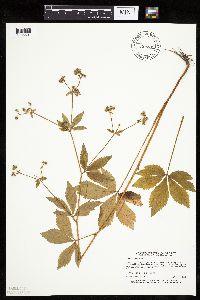 464605[1035601]Dunevitz, H. 8741993-09-09 United States, Minnesota, Winona, Winona Co.; Two miles south and east of Dresbach on bluff above Highway 61 and the Mississippi River; T 105 R 4 SW1/4 of Winona Co.; Two miles south and east of Dresbach on bluff above Highway 61 and the Mississippi River; T 105 R 4 SW1/4 of NE1/4 of Sec 29. 105N 04W 29, 43.868743 -91.33113 |
MIN:Plants | 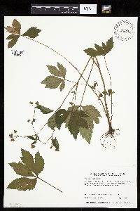 464629[1035591]Harris, Fred 941011994-07-20 United States, Minnesota, Olmsted, Olmsted Co.; Whitewater WMA; SE1/4 of SE1/4 of NW1/4 Sect. 3 T107N R11W;Whitewater Wildlife Management Area;107N;11W;3, 44.099734 -92.129265 |
MIN:Plants | 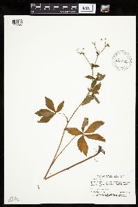 466629[1035628]Dunevitz, H. 8841993-09-24 United States, Minnesota, Winona, Winona County...Bluff south of County Road 17, 5 miles east of Hart...T 105 R 7 SSE1/4 of NE1/4 of sec 23;Dorer Memorial Hardwood State Forest;105N;07W;23, 43.882872 -91.63004 |
MIN:Plants | 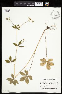 472039[1035590]Dunevitz, H. 8751993-09-08 United States, Minnesota, Winona, Winona Co.; One mile east of County Road 3, 1/2 mile west of O.L. Kipp State Park; T 106 R 5 SE1/4 of NE1/4 of Sec 28;;106N;05W;28, 43.955339 -91.430646 |
MIN:Plants |  514482[1035614]Harris, Fred 950781995-08-23 United States, Minnesota, Carver, Carver Co.; N side of Minnesota river valley; T114 R24 NW1/4 of NE1/4 of Sec 15;;114N;24W;15, 44.676797 -93.687376 |
MIN:Plants |  514703[1035585]Zager, S. 950720-41995-07-20 United States, Minnesota, Fillmore, Fillmore County...T104N R08W SE1/4, NW1/4, SW1/4, 18;Dorer Memorial Hardwood State Forest;104N;08W;18, 43.810744 -91.840177 |
MIN:Plants |  516240[1035618]Kern, Carole 21731993-08-26 United States, Minnesota, Houston, Houston Co.; Location: T-104-N R-4-W SEC.32 SW4 SE4. Mt.Tom, Hokah;Dorer Memorial Hardwood State Forest;104N;04W;32, 43.767669 -91.343423 |
MIN:Plants |  519881[1035586]Zager, S. 950801-31995-08-01 United States, Minnesota, Fillmore, Fillmore County...S facing bluff at confluence of ravine and valley...T104N R09W SE1/4, NE1/4, NE1/4, SW1/4, 28;Dorer Memorial Hardwood State Forest;104N;09W;28, 43.781994 -91.920013 |
MIN:Plants | 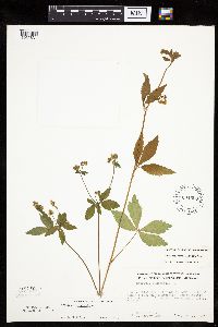 604509[1035631]Olson, Edmund; et al. 12101967-07-16 United States, Minnesota, Blue Earth, Blue Earth County...isolated NNW-SSE ridge in city limits of Mankato near N boundary, approx. the W1/2 sec. 6, Mankato Twp, T 108N, R 26W. 108N 26W 6, 44.182552 -94.006963 |
MIN:Plants | 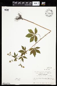 737250[1035587]Kachman, R. 5301981-07-27 United States, Minnesota, Freeborn, next to rr grade, ca 1/4 mi W of the Bur Oak Esker Trail in Helmer Myre State Park;Myre Big Island State Park;N;;, 43.636519 -93.307144 |
MIN:Plants | 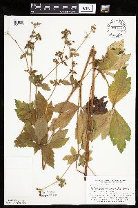 770152[1035597]Smith, Welby 87501983-08-28 United States, Minnesota, Jackson, Kilen Woods State Park, ca 8 mi NNW of Jackson, Des Moines River Valley, SW1/4 NE1/4 S17, T103N, R35W;Kilen Woods State Park;103N;35W;17, 43.724814 -95.064648 |
MIN:Plants | 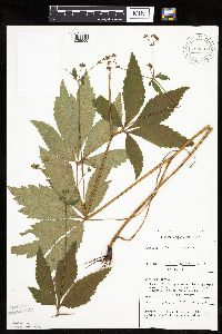 782337[1035595]Tenney, M. 3341982-06-30 United States, Minnesota, Fillmore, Forestville State Park. Fillmore Co. T102N, R12W, S13, NW1/4 NW1/4 NE1/4;Forestville State Park;102N;12W;13, 43.637724 -92.219269 |
MIN:Plants |  782603[1035610]Tenney, M. 4281982-07-15 United States, Minnesota, Fillmore, Forestville State Park, Fillmore Co. T102N, R11W, S18, NE1/4 NE1/4 NE1/4;Forestville State Park;102N;11W;18, 43.637926 -92.199183 |
MIN:Plants |  Sanicula canadensis var. grandis Fernald 782606[1035578]Tenney, M. 4741982-07-22 United States, Minnesota, Fillmore, Forestville State Park, Fillmore County...T102N, R12W, S13, NE1/4 SW1/4 SE1/4;Forestville State Park;102N;12W;13, 43.637724 -92.219269 |
MIN:Plants |  829385[1035612]Zager, S. 920827761992-08-27 United States, Minnesota, Houston, Houston Co. 1/2 mi S by SW of co.rd.jnc. T-270/T-272 in ravine; T104-R07W, SE1/4 SW1/4 27 MCBS Site #3;Dorer Memorial Hardwood State Forest;104N;07W;27, 43.781685 -91.660731 |
MIN:Plants |  829387[1035611]Zager, S. 920721-21992-07-21 United States, Minnesota, Houston, Dorer Memorial Hardwood State Forest. Houston Co. Located in state forest 1 mi W of jnc. T-227/Hwy 22 on ridge between forked headwater ravines of Sweede bott Houston Co. Located in state forest 1 mi W of jnc. T-227/Hwy 22 on ridge between forked headwater ravines of Sweede bottom creek canyon; T103N-R06W, OS1/4[sic] NW1/4 14 MCBS Site #52. 103N 06W 14, 43.725046 -91.521469 |
MIN:Plants | 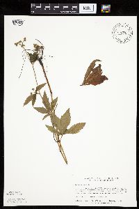 829400[1035626]Zager, S. 920820421992-08-20 United States, Minnesota, Houston, Houston Co. 1/2 mi S of co.rd.jnc. T-270/T-272 on canyon slopes; T104N-R07W, NW1/4 SE1/4 27 MCBS Site #3;Dorer Memorial Hardwood State Forest;104N;07W;27, 43.781685 -91.660731 |
MIN:Plants | 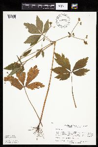 829445[1035613]Zager, S. 920822601992-08-22 United States, Minnesota, Houston, Houston Co. 1/2 mi S/SW of co.rd.jnc. T-270/T-272 on E-face canyon slopes; T104N-R07W, SW1/4 SE1/4 27 MCBS Site #3;Dorer Memorial Hardwood State Forest;104N;07W;27, 43.781685 -91.660731 |
MIN:Plants | 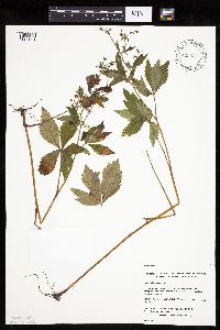 829635[1035621]Zager, S. 930908-31993-09-08 United States, Minnesota, Houston, Houston Co.; MCBS #141c. E1/2 NE1/4 NE1/4 Sec.13 T101N R05W;Dorer Memorial Hardwood State Forest;101N;05W;13, 43.551193 -91.382132 |
MIN:Plants | 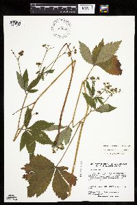 Sanicula canadensis var. grandis Fernald 829638[1035577]Zager, S. 930810-11993-08-10 United States, Minnesota, Houston, Houston County...MCBS #50. Legal: NE1/4 NE1/4 SE1/4 Sec 05 T103N R06W.;Dorer Memorial Hardwood State Forest;103N;06W;05, 43.753129 -91.581097 |
MIN:Plants |  829662[1035617]Nation, R. 12881993-08-31 United States, Minnesota, Wabasha, Wabasha Co. 2 1/2 mi E [must mean W] of Minneiska, 1/3 mi N of Winona Co. line, along Co.Rd.29; T109N R09W NW1/4 of SW1/ Wabasha Co. 2 1/2 mi E [must mean W] of Minneiska, 1/3 mi N of Winona Co. line, along Co.Rd.29; T109N R09W NW1/4 of SW1/4 of Sec 32.. 109N 09W 32, 44.200317 -91.919685 |
MIN:Plants |  829674[1035581]Nation, R. 12211993-07-30 United States, Minnesota, Wabasha, Whitewater Wildlife Management Area. Wabasha County...Whitewater Wildlife Management Area, about 2 mi W and 1 mi S of Weaver...T109N R10W SE1/4 of NW1/4 of Sec 36.. 109N 10W 36, 44.200303 -91.959553 |
MIN:Plants |  829675[1035622]Nation, R. 12701993-08-23 United States, Minnesota, Wabasha, Wabasha Co. Kruger Management Area; T110N R10W NE1/4 of SW1/4 of Sec 18.;Dorer Memorial Hardwood State Forest;110N;10W;19, 44.315567 -92.059419 |
MIN:Plants |  829677[1035619]Nation, R. 12231993-08-02 United States, Minnesota, Winona, Winona Co. 3/4 mi S of jnc. of U.S. 61 and Co.Rd.7; T106N R05W NE1/4 of NE1/4 of Sec.18;Dorer Memorial Hardwood State Forest;106N;05W;18, 43.984187 -91.470519 |
MIN:Plants |  829706[1035583]Nation, R.; et al. 12911993-09-01 United States, Minnesota, Winona, Dorer Memorial Hardwood State Forest. Winona County...About 5 mi S and 1/2 mi W of Centerville, along State Hwy. 76, and 1 1/4 mi N of Houston County line T105N R07W SW1/4 of SW1/4 of Sec.26. 105N 07W 26, 43.868451 -91.629933 |
MIN:Plants |  829776[1035615]Kern, Carole 21881993-09-01 United States, Minnesota, Houston, Houston Co. MCBS #088. T-104-N R-5-W Sec.34 NW4 SW4; State land. Just above the bluff prairie;Dorer Memorial Hardwood State Forest;104N;05W;34, 43.767742 -91.42281 |
MIN:Plants |  829796[1035616]Zager, S. 930901-51993-09-01 United States, Minnesota, Houston, Houston Co. State Forest; MCBS #98, SE1/4 SE1/4 NE1/4 Sec 24 T103N R06W;Dorer Memorial Hardwood State Forest;103N;06W;24, 43.710568 -91.501545 |
MIN:Plants |  829799[1035576]Zager, S. 930907-31993-09-07 United States, Minnesota, Houston, Houston Co. Hell's Canyon State SNA; MCBS #129, NE1/4 NE1/4 SE1/4 Sec 23 T102N R04W;Dorer Memorial Hardwood State Forest;102N;04W;23, 43.622924 -91.282683 |
MIN:Plants | 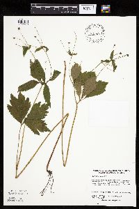 829801[1035620]Zager, S. 930813-51993-08-13 United States, Minnesota, Houston, Houston Co. In State Forest; MCBS #89, NW1/4 NW1/4 Sec 34 T104N R05W;Dorer Memorial Hardwood State Forest;104N;05W;34, 43.767742 -91.42281 |
MIN:Plants |  829814[1035582]Zager, S. 930908-41993-09-08 United States, Minnesota, Houston, Houston County...In State Forest lands...MCBS #141c, Legal: NW1/4 SE1/4 SE1/4 Sec.13 T101N R05W;Dorer Memorial Hardwood State Forest;101N;05W;13, 43.551193 -91.382132 |
MIN:Plants |  836025[1035625]Smith, Welby 199141991-08-06 United States, Minnesota, Le Sueur, Chamberlain Woods Scientific Natural Area. Le Sueur County...Chamberlain Woods State Scientific and NaturalArea, about 3 mi S-SW of Le Sueur. In the Minnesota Valley...T111N R26W SW1/4 of SW1/4 of Sec 22. 111N 26W 22, 44.4005556 -93.8972222 |
MIN:Plants |  Sanicula gregaria E.P. Bicknell 164935[1035701]Rosendahl, C. 24851910-06-10 United States, Minnesota, Snelling Reservation [old regional park spanning junction of Minnesota and Mississippi rivers];;028N;23W;, 44.90516 -93.16646 |
MIN:Plants |  Sanicula gregaria E.P. Bicknell 164965[1035707]Rosendahl, C. 12601903-06-08 United States, Minnesota, McLeod, Near Hutchinson;;N;;, 44.88774 -94.369706 |
MIN:Plants |  Sanicula gregaria E.P. Bicknell 164966[1035692]Butters, F.; et al. R27391914-06-00 United States, Minnesota, Wright, Near Rockford;;;;, 45.0875 -93.741667 |
MIN:Plants |  Sanicula gregaria E.P. Bicknell 164968[1035690]Rosendahl, C.; et al. 40061921-06-17 United States, Minnesota, Big Stone, E side of Big Stone Lake.;;;;, 45.409244 -96.610864 |
MIN:Plants |  Sanicula gregaria E.P. Bicknell 164969[1035691]Holzinger, John s.n.1886-05-00 United States, Minnesota, Winona, [no further data];;;;, 43.972094 -91.701335 |
MIN:Plants |  Sanicula gregaria E.P. Bicknell 164970[1035703]Rosendahl, C. 3691902-06-05 United States, Minnesota, Houston, Spring Grove;;101N;07W;, 43.543923 -91.6707 |
MIN:Plants |  Sanicula gregaria E.P. Bicknell 164971[1122420]Burglehaus, F. s.n.1891-06-00 United States, Minnesota, Hennepin, [no further data];;;;, 45 -93.47 |
MIN:Plants |  Sanicula gregaria E.P. Bicknell 164972[1122418]Holzinger, John s.n.1886-07-00 United States, Minnesota, Winona, [no further data];;N;;, 43.972094 -91.701335 |
MIN:Plants |  Sanicula gregaria E.P. Bicknell 164973[1035687]Rosendahl, C. 22691909-07-10 United States, Minnesota, Snelling Reservation [old regional park spanning junction of Minnesota and Mississippi rivers];;028N;23W;, 44.90516 -93.16646 |
MIN:Plants |  Sanicula gregaria E.P. Bicknell 164974[1035719]Ballard, C. B3901891-07-00 United States, Minnesota, Scott, Jordan, Scott Co.;;114N;23W;, 44.674435 -93.582701 |
MIN:Plants |  Sanicula gregaria E.P. Bicknell 164977[1035727]Wheeler, William 1771899-06-12 United States, Minnesota, Houston, Winebago Valley, Houston Co.;Dorer Memorial Hardwood State Forest;N;;, 43.536598 -91.399388 |
MIN:Plants |  Sanicula gregaria E.P. Bicknell 164978[1035716]Sheldon, Edmund s.n.1892-07-00 United States, Minnesota, Mille Lacs, Milaca;;036N;26W;, 45.755799 -93.654408 |
MIN:Plants |  Sanicula gregaria E.P. Bicknell 164979[1035669]Rosendahl, C. 5621902-06-19 United States, Minnesota, Houston, Spring Grove;;101N;07W;, 43.543923 -91.6707 |
MIN:Plants |  Sanicula gregaria E.P. Bicknell 164980[1035682]Sheldon, Edmund S1411891-06-00 United States, Minnesota, Blue Earth, Madison Lake;;N;;, 44.152492 -93.828355 |
MIN:Plants |  Sanicula gregaria E.P. Bicknell 165022[1122417]Moyer, Lycurgus 2664 United States, Minnesota, Upper Minn. Valley. Nelson's Grove.;;;;, 44.740445 -93.614108 |
MIN:Plants |  Sanicula gregaria E.P. Bicknell 165051[1035715]Rosendahl, C. 6061902-06-25 United States, Minnesota, Houston, Spring Grove;;101N;07W;, 43.543923 -91.6707 |
MIN:Plants |  Sanicula gregaria E.P. Bicknell 360247[1035677]Lakela, Olga 35951940-06-30 United States, Minnesota, Saint Louis, Banks of Mission Creek, Fond du Lac;;N;;, 46.66932 -92.27563 |
MIN:Plants |  Sanicula gregaria E.P. Bicknell 363818[1035705]Butters, F.; et al. 67051936-08-20 United States, Minnesota, Fillmore, Root River Valley along Hwy. W of Peterson;;;;, 43.786349 -91.864968 |
MIN:Plants |  Sanicula gregaria E.P. Bicknell 363820[1035681]Rosendahl, C. 68041937-06-29 United States, Minnesota, Fillmore, 1 1/2 mi. W of Peterson;;N;;, 43.786349 -91.864968 |
MIN:Plants |  Sanicula gregaria E.P. Bicknell 373972[1035671]Linnaean Club, U of M, 2151940-10-13 United States, Minnesota, Rice, Nerstrand Woods. Rice Co. E-slope;Nerstrand Woods State Park;110N;19W;, 44.327064 -93.100886 |
MIN:Plants |  Sanicula gregaria E.P. Bicknell 385718[1035695]Rosendahl, C. 76991944-07-19 United States, Minnesota, Fillmore, About 1 mi N of Fountain, along Hwy. 52.;;103N;11W;, 43.717407 -92.149379 |
MIN:Plants | 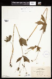 Sanicula gregaria E.P. Bicknell 422728[1035679]Lakela, Olga 77581948-08-22 United States, Minnesota, Saint Louis, Mission Creek Woods at Fond du Lac;;N;;, 46.68122 -92.28584 |
MIN:Plants | 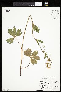 Sanicula gregaria E.P. Bicknell 443873[1035724]Myhre, K. 40331993-07-05 United States, Minnesota, Pine, Banning State Park. Pine Co.; Located 2 miles northeast of the town of Sandstone, along a west-facing sandstone escarpment of the Kettle Riv Pine Co.; Located 2 miles northeast of the town of Sandstone, along a west-facing sandstone escarpment of the Kettle River; T 43N R 20W NW1/4 of SE1/4 of sec 35. 043N 20W 35, 46.165145 -92.834884 |
MIN:Plants | 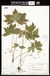 Sanicula gregaria E.P. Bicknell 445162[1035713]Moore, John; et al. 175191945-06-29 United States, Minnesota, Isanti, 4 mi. S of Braham;;;;, 45.664821 -93.170776 |
MIN:Plants | 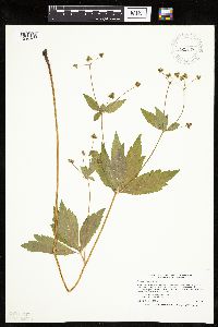 Sanicula gregaria E.P. Bicknell 445588[1035725]Smith, Welby 206121992-06-25 United States, Minnesota, Redwood, Redwood Falls; In Alexander Ramsey city park in Redwood Falls; in the Redwood River Valley; T 113N R 36W NW1/4 of SE1/4 of Sec 36. 113N 36W 36, 44.5480556 -95.1244444 |
MIN:Plants |  Sanicula gregaria E.P. Bicknell 446220[1035683]Moore, John; Huff, N. 188751946-08-01 United States, Minnesota, Benton, 2 mi. SW of Foley;;036N;29W;, 45.603678 -93.945583 |
Google Map
Google Maps is a web mapping service provided by Google that features a map that users can pan (by dragging the mouse) and zoom (by using the mouse wheel). Collection points are displayed as colored markers that when clicked on, displays the full information for that collection. When multiple species are queried (separated by semi-colons), different colored markers denote each individual species.