University of Minnesota
http://www.umn.edu/
612-625-5000
http://www.umn.edu/
612-625-5000
Minnesota Biodiversity Atlas
Bell Museum
Dataset: MIN-Plants
Taxa: Apiaceae
Search Criteria: excluding cultivated/captive occurrences
Bell Museum plants | |
 MIN:Plants | 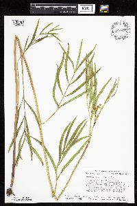 Oxypolis rigidior (L.) Rafinesque 724589[1035443]Smith, Welby 28431980-07-17 United States, Minnesota, Dodge, Dodge Co. T105N, R17W, SE1/4 SE1/4 Sec. 33. Between the Chicago and Northwestern R.R. tracks and Hwy. 56. 2 mi. S of H Dodge Co. T105N, R17W, SE1/4 SE1/4 Sec. 33. Between the Chicago and Northwestern R.R. tracks and Hwy. 56. 2 mi. S of Hayfield and 100 m N of Mower Co. line.. 105N 17W 33, 43.855991 -92.869084 |
MIN:Plants | 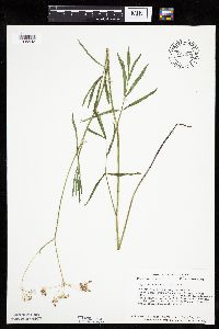 Oxypolis rigidior (L.) Rafinesque 725004[1035442]Smith, Welby 37041980-09-19 United States, Minnesota, Scott, About 1/2 mi. W of downtown Savage, and 1/4 mi. S of Hwy. 13. SE1/4 NE1/4 of section;Savage Fen Scientific Natural Area;115N;21W;17, 44.768126 -93.369003 |
MIN:Plants | 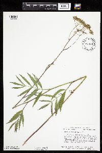 Oxypolis rigidior (L.) Rafinesque 726339[1035441]Smith, Welby 36361980-08-07 United States, Minnesota, Scott, Scott Co. T115N, R21W, SE1/4 SE1/4 Sec. 17. Ca. 1 mi. W of downtown Savage, and 1/2 mi. S of Hwy. 13.;Savage Fen Scientific Natural Area;115N;21W;17, 44.768126 -93.369003 |
MIN:Plants | 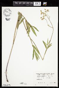 Oxypolis rigidior (L.) Rafinesque 732777[1035448]Heidel, B. 711981-07-22 United States, Minnesota, Olmsted, Olmsted Co. 1 1/4 mi E of Eyota;;106N;11W;, 43.977142 -92.139081 |
MIN:Plants |  Oxypolis rigidior (L.) Rafinesque 737304[1035467]Kachman, R. 4211980-08-19 United States, Minnesota, Mower, NW section of Adams Community Park.;;N;;, 43.56456 -92.72418 |
MIN:Plants |  Oxypolis rigidior (L.) Rafinesque 744851[1035476]Smith, Welby 52221981-08-04 United States, Minnesota, Mower, Ca. 5 mi. NNW of Le Roy. SW1/4 NE1/4 Sec. 5, T101N, R14W.;;101N;14W;5, 43.580048 -92.539234 |
MIN:Plants |  Oxypolis rigidior (L.) Rafinesque 744854[1035475]Smith, Welby 52581981-08-05 United States, Minnesota, Steele, In the town of Blooming Prairie. Between Hwy. 218 and the Chicago, Milwaukee, St. Paul and Pacific R.R. tracks.;;105N;19W;25, 43.870227 -93.055453 |
MIN:Plants |  Oxypolis rigidior (L.) Rafinesque 744861[1035478]Smith, Welby 52741981-08-05 United States, Minnesota, Steele, In the town of Blooming Prairie. Strip between Hwy. 218 and the Chicago, Milwaukee, St. Paul and Pacific R.R. tracks. In the town of Blooming Prairie. Strip between Hwy. 218 and the Chicago, Milwaukee, St. Paul and Pacific R.R. tracks. NW1/4 NE1/4 Sec. 25, T105N, R19W.. 105N 19W 25, 43.870227 -93.055453 |
MIN:Plants | 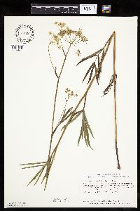 Oxypolis rigidior (L.) Rafinesque 744984[1035477]Smith, Welby 52401981-08-04 United States, Minnesota, Fillmore, Fillmore Co. About 9 mi SSE of Ostrander. SE1/4 Sec. 27, T101N, R13W.;;101N;13W;27, 43.522286 -92.379353 |
MIN:Plants | 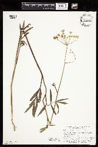 Oxypolis rigidior (L.) Rafinesque 745146[1035454]Smith, Welby 53421981-08-06 United States, Minnesota, Faribault, Ca. 3.5 mi. SE of Wells. Between Hwy. 109 and the Chicago, Milwaukee, St. Paul and Pacific R.R. tracks. SE1/4 SE1/4 Se Ca. 3.5 mi. SE of Wells. Between Hwy. 109 and the Chicago, Milwaukee, St. Paul and Pacific R.R. tracks. SE1/4 SE1/4 Sec. 14, T103N, R24W.. 103N 24W 14, 43.724342 -93.678266 |
MIN:Plants | 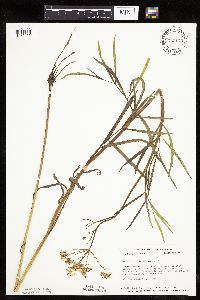 Oxypolis rigidior (L.) Rafinesque 745175[1035455]Smith, Welby 52861981-08-05 United States, Minnesota, Dodge, Dodge Co. About 2 mi N of the jct. of Hwy. 56 and Hwy. 24 in West Concord. Between Hwy. 56 and the Chicago and Northwes Dodge Co. About 2 mi N of the jct. of Hwy. 56 and Hwy. 24 in West Concord. Between Hwy. 56 and the Chicago and Northwestern R.R. tracks. NW1/4 NE1/4 Sec. 7, T108N, R17W.. 108N 17W 7, 44.175198 -92.912382 |
MIN:Plants | 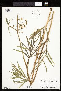 Oxypolis rigidior (L.) Rafinesque 745223[1035456]Smith, Welby 49741981-07-21 United States, Minnesota, Mower, Wild Indigo Scientific and Natural Area. Ca. 2 1/2 mi. W of Dexter. SW1/4 NE1/4 Sec. 16, T103N, R16W;Wild Indigo Scientific Natural Area;103N;16W;16, 43.724883 -92.759467 |
MIN:Plants |  Oxypolis rigidior (L.) Rafinesque 745251[1035461]Smith, Welby 56641981-09-03 United States, Minnesota, Freeborn, Ca. 1/2 mi. S of the jct. of Hwy. 13 and Hwy. 14. Strip between Hwy. 13 and the Chicago and Northwestern R.R. tracks. Ca. 1/2 mi. S of the jct. of Hwy. 13 and Hwy. 14. Strip between Hwy. 13 and the Chicago and Northwestern R.R. tracks. NW1/4 NE1/4 T103N, R22W.. 103N 22W 26, 43.694883 -93.438616 |
MIN:Plants |  Oxypolis rigidior (L.) Rafinesque 745297[1035472]Smith, Welby 52871981-08-05 United States, Minnesota, Waseca, Ca. 2 1/2 mi. WNW of the jct. of Hwy. 14 and Hwy. 13 in Waseca. Prairie strip between Hwy. 14 and the Chicago and North Ca. 2 1/2 mi. WNW of the jct. of Hwy. 14 and Hwy. 13 in Waseca. Prairie strip between Hwy. 14 and the Chicago and Northwestern R.R. tracks. NW1/4 NE1/4 Sec. 11, T107N, R23W.. 107N 23W 11, 44.087544 -93.557058 |
MIN:Plants |  Oxypolis rigidior (L.) Rafinesque 745319[1035444]Smith, Welby 56471981-09-02 United States, Minnesota, Dodge, Dodge Co. About 2 mi S of Hayfield and 100 m N of the Mower-Dodge Co. line. Strip between Hwy. 56 and the Chicago and N Dodge Co. About 2 mi S of Hayfield and 100 m N of the Mower-Dodge Co. line. Strip between Hwy. 56 and the Chicago and Northwestern R.R. tracks. SE1/4 SE1/4 Sec. 33, T105N, R17W.. 105N 17W 33, 43.855991 -92.869084 |
MIN:Plants |  Oxypolis rigidior (L.) Rafinesque 745353[1035453]Smith, Welby 53521981-08-06 United States, Minnesota, Freeborn, Ca. 4 mi. ENE of Hayward. Strip between Hwy. 46 and the Chicago, Milwaukee, St. Paul and Pacific R.R. NE1/4 SW1/4 Sec Ca. 4 mi. ENE of Hayward. Strip between Hwy. 46 and the Chicago, Milwaukee, St. Paul and Pacific R.R. NE1/4 SW1/4 Sec. 1, T102N, R20W.. 102N 20W 1, 43.666432 -93.179094 |
MIN:Plants |  Oxypolis rigidior (L.) Rafinesque 745405[1035468]Smith, Welby 52601981-08-05 United States, Minnesota, Steele, Ca. 3 mi. NW of Bixby and 200 m NW of Turtle Creek crossing. Strip between Hwy. 218 and the Chicago, Milwaukee, St. Pau Ca. 3 mi. NW of Bixby and 200 m NW of Turtle Creek crossing. Strip between Hwy. 218 and the Chicago, Milwaukee, St. Paul, and Pacific R.R. tracks. SE1/4 SE1/4 Sec. 17, T106N R19W.. 106N 19W 17, 43.986417 -93.13606 |
MIN:Plants |  Oxypolis rigidior (L.) Rafinesque 745409[1035469]Smith, Welby 52831981-08-05 United States, Minnesota, Steele, Ca. 1 1/2 mi. ESE of Havana. Strip between Hwy. 14 and the Chicago and Northwestern R.R. tracks. NE1/4 SW1/4 Sec. 21, Ca. 1 1/2 mi. ESE of Havana. Strip between Hwy. 14 and the Chicago and Northwestern R.R. tracks. NE1/4 SW1/4 Sec. 21, T107N, R19W.. 107N 19W 21, 44.059162 -93.116148 |
MIN:Plants |  Oxypolis rigidior (L.) Rafinesque 758234[1035446]Smith, Welby 71301982-08-08 United States, Minnesota, Dakota, Dakota Co. About 1 mi S of Black Dog Lake in the Minnesota Valley. NW1/4 NE1/4 Sec. 34, T27N, R24W.;Black Dog Preserve Scientific Natural Area;027N;24W;34, 44.783133 -93.278618 |
MIN:Plants |  Oxypolis rigidior (L.) Rafinesque 758255[1035445]Smith, Welby 71451982-08-10 United States, Minnesota, Dakota, Fort Snelling State Park. Dakota Co. Fort Snelling State Park. In the Minnesota Valley, 1/2 mi. E of Gun Club Lake. Se1/4 NW1/4 Sec. 4, T27N, R2 Dakota Co. Fort Snelling State Park. In the Minnesota Valley, 1/2 mi. E of Gun Club Lake. Se1/4 NW1/4 Sec. 4, T27N, R23W.. 027N 23W 4, 44.854997 -93.177298 |
MIN:Plants | 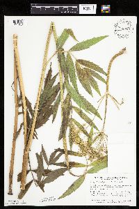 Oxypolis rigidior (L.) Rafinesque 759043[1035457]Smith, Welby 69771982-07-30 United States, Minnesota, Mower, Brandt-Larson Wildlife Management Area. Brandt-Larson State Wildlife Management Area. Ca. 4 mi. NE of Lyle. Along Otter Creek. NE1/4 SW1/4 Sec. 16, T101N, R1 Brandt-Larson State Wildlife Management Area. Ca. 4 mi. NE of Lyle. Along Otter Creek. NE1/4 SW1/4 Sec. 16, T101N, R17W.. 101N 17W 16, 43.550746 -92.878835 |
MIN:Plants | 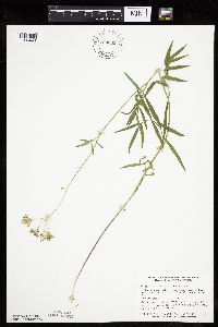 Oxypolis rigidior (L.) Rafinesque 759063[1035449]Smith, Welby 75911982-09-11 United States, Minnesota, Dakota, Dakota County...In the Minnesota Valley, about 1/4 mi. N of Nicols. NE1/4 SW1/4 Sec. 18, T27N, R23W.;Fort Snelling State Park;027N;23W;18, 44.825884 -93.216999 |
MIN:Plants | 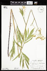 Oxypolis rigidior (L.) Rafinesque 759172[1035458]Smith, Welby 69221982-07-28 United States, Minnesota, Mower, Racine Prairie Scientific Natural Area. Racine Prairie State Scientific and Natural Area. Adjacent to the E side of Hwy. 63, ca. 2 mi. N of Racine. NE1/4 NE1/ Racine Prairie State Scientific and Natural Area. Adjacent to the E side of Hwy. 63, ca. 2 mi. N of Racine. NE1/4 NE1/4 Sec. 22, T104N, R14W.. 104N 14W 22, 43.797643 -92.499267 |
MIN:Plants | 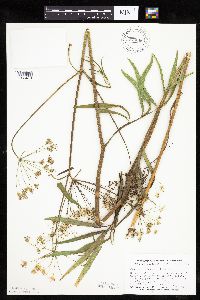 Oxypolis rigidior (L.) Rafinesque 770666[1035473]Smith, Welby 84721983-07-27 United States, Minnesota, Fillmore, Fillmore Co. About 3 mi SE of Spring Valley. NW1/4 SE1/4 Sec. 12, T102N, R13W;;102N;13W;12, 43.652708 -92.339378 |
MIN:Plants | 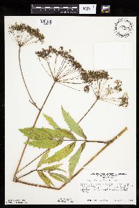 Oxypolis rigidior (L.) Rafinesque 775027[1035447]Morley, T. 15691984-09-23 United States, Minnesota, Rice, Cannon River Valley. E of river and house, directly E of sharp turn in river. Center of E1/4 of section;;111N;20W;22, 44.4066 -93.210944 |
MIN:Plants | 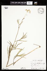 Oxypolis rigidior (L.) Rafinesque 787236[1035474]Smith, Welby 110161985-08-10 United States, Minnesota, Dodge, Iron Horse Prairie Scientific Natural Area. Dodge County...Iron Horse Prairie State Scientific and Natural Area, about 1 1/2 mi. S of Hayfield. NW1/4 SE1/4 Sec. 27, T105N, R17W. 105N 17W 27, 43.8675 -92.8486111 |
MIN:Plants | 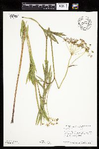 Oxypolis rigidior (L.) Rafinesque 789583[1035471]Smith, Welby 112811985-09-07 United States, Minnesota, Olmsted, Olmsted Co. About 2 mi SSE of Rock Dell and 1/4 mi N of Hwy. 30. NW1/4 SW1/4 SE1/4 Sec. 16, T105N, R15W;;105N;15W;16, 43.894722 -92.6255569 |
MIN:Plants | 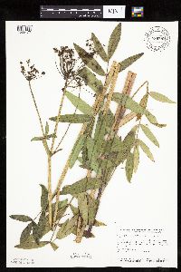 Oxypolis rigidior (L.) Rafinesque 789589[1035470]Smith, Welby 112971985-09-08 United States, Minnesota, Ramsey, Maplewood Nature Center. Ramsey County... In the city of Maplewood, about 1/2 mi. S of Larpenteur Ave. and 1/2 mi. E of McKnight Road. NW1/4 SE1/4 Sec. 24, T 29N, R 22W. 029N 22W 24, 44.9838889 -92.9936111 |
MIN:Plants | 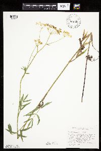 Oxypolis rigidior (L.) Rafinesque 805871[1035452]Cholewa, A. 18321989-09-01 United States, Minnesota, Dakota, Fort Snelling State Park. Dakota Co. 'Nicols Fen', ca. 100 yds. NE of jct. of Cedar Ave. and Chicago Northwestern R.R. T27N, R23W, Sec. 18, just SW of the center.. 027N 23W 18, 44.825884 -93.216999 |
MIN:Plants | 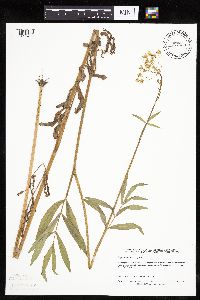 Oxypolis rigidior (L.) Rafinesque 827559[1035463]Almendinger, J. s.n.1990-08-09 United States, Minnesota, Ramsey, Ramsey Co.; about 200 yards E-SE of turn where Maryland St. turns N as Ruth St, S of tracks; Hazel Park Prairie. NW1/4 Ramsey Co.; about 200 yards E-SE of turn where Maryland St. turns N as Ruth St, S of tracks; Hazel Park Prairie. NW1/4 NW1/4 NE1/4 sec.26, T29N, R22W. 029N 22W 26, 44.970283 -93.015203 |
MIN:Plants | 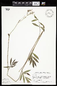 Oxypolis rigidior (L.) Rafinesque 828569[1035465]Delaney, B. 902471990-09-12 United States, Minnesota, Sherburne, Sherburne Co.; 1 mi W of St. Cloud airport on S side of Co.Rd.7. NW1/4 SW1/4 sec.4, T35N, R30W;;035N;30W;4, 45.551948 -94.079149 |
MIN:Plants | 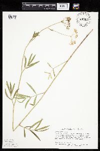 Oxypolis rigidior (L.) Rafinesque 830312[1035464]Delaney, B. 91268.11991-08-19 United States, Minnesota, Benton, Benton County...3 mi S of village of Popple Creek and 0.75 mi W of the Elk River...NW/14 NW1/4 sec. 14, T36N R30W;;036N;30W;14, 45.6158333 -94.0466667 |
MIN:Plants |  Oxypolis rigidior (L.) Rafinesque 832152[1035429]Morley, T. 17241992-08-08 United States, Minnesota, Dakota, Dakota Co.; W side of a drainage way; T114N, R20W, NE1/4 NE1/4 sec.13, Lakeville Twp.;;114N;20W;13, 44.681413 -93.166665 |
MIN:Plants |  Oxypolis rigidior (L.) Rafinesque 834171[1035480]Smith, Welby 197651991-07-24 United States, Minnesota, Winona, Whitewater Wildlife Management Area. Winona County...About 3.5 mi N of Elba. On the N side of Randall Pool in the White Water State Wildlife Management Area (on the W side of CSAH 74); T108N R10W SW1/4 of SE1/4 of Sec 22. 108N 10W 32, 44.1369438 -92.0063858 |
MIN:Plants |  Oxypolis rigidior (L.) Rafinesque 839137[1035431]Smith, Welby 176671990-08-02 United States, Minnesota, Dodge, Vorce Wildlife Management Area. Dodge Co. Vorce State Wildlife Management Area, about 2 mi N-NE of Claremont; Dodge Co. Vorce State Wildlife Management Area, about 2 mi N-NE of Claremont; T107N R18W SE1/4 of SW1/4 of Sec 15.. 107N 18W 15, 44.0686111 -92.9788895 |
MIN:Plants |  Oxypolis rigidior (L.) Rafinesque 919602[1035500]Anderson, Derek 14032009-09-02 United States, Minnesota, Dodge, Dodge County...About 4 km southeast of West Concord...T108N, R17W, SWSW27;;108N;17W;27, 44.1258333 -92.8583333 |
MIN:Plants | 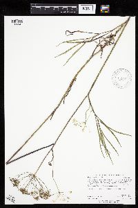 Oxypolis rigidior (L.) Rafinesque 919394[1035501]Anderson, Derek 13732009-08-26 United States, Minnesota, Dodge, Dodge County...On the east side of Eden just south of Highway 16...T107N, R17W, NESE08;;107N;17W;08, 44.0872222 -92.8805556 |
MIN:Plants | 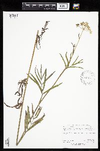 Oxypolis rigidior (L.) Rafinesque 919133[1035498]Anderson, Derek 13482009-08-19 United States, Minnesota, Freeborn, Freeborn County...about 2.25 miles south of the Freeborn-Steele County line on 890th Ave (east side)...T104N R19W NWNW14;;104N;19W;14, 43.8161111 -93.0894444 |
MIN:Plants |  Oxypolis rigidior (L.) Rafinesque 479238[1035466]Harris, Fred 960571996-06-13 United States, Minnesota, Olmsted, Goodhue Co.; T 105N R 15W NE1/4 of NW1/4 of Sec 23;;105N;15W;23, 43.884551 -92.588394 |
MIN:Plants | 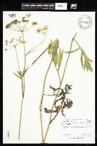 Oxypolis rigidior (L.) Rafinesque 913070[1035492]Anderson, Derek 10582008-08-19 United States, Minnesota, Freeborn, Magaksica Wildlife Management Area. Freeborn County ... Magaksica WMA, located in western Albert Lea, near the small stream feading [sic] the northwest corner of Pickerel Lake ... T102N, R22W, SESE 11. 102N 22W 11, 43.6472222 -93.4291667 |
MIN:Plants | 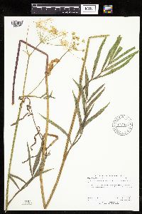 Oxypolis rigidior (L.) Rafinesque 913046[1035491]Anderson, Derek 9572008-08-04 United States, Minnesota, Freeborn, Freeborn County ...Ca. 3.25 mile west of Deer Creek on the north side of the Minnesota-Iowa State Line Road ... T101N, R20W, SESE36. 101N 20W 36, 43.5068423 -93.1791892 |
MIN:Plants | 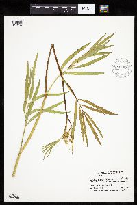 Oxypolis rigidior (L.) Rafinesque 911880[1035488]Smith, Welby 229451993-07-15 United States, Minnesota, Fillmore, Beaver Creek Wildlife Management Area. Fillmore County...Beaver Creek State Wildlife Management Area; about 9.5 miles south of Spring Valley...T 101N R 31W NE1/4 of SW1/4 of Sec 21. 101N 31W 21, 43.5341667 -92.4025 |
MIN:Plants | 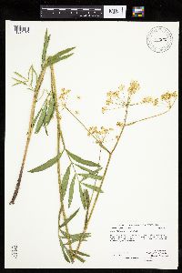 Oxypolis rigidior (L.) Rafinesque 912859[1035460]Anderson, Derek 9542008-08-02 United States, Minnesota, Mower, Mower County ... Cartney WMA, ca. 8.5 km north of Le Roy ... T101N, R14W, SWNE 05;Cartney Wildlife Management Area;101N;14W;05, 43.5808333 -92.5355556 |
MIN:Plants | 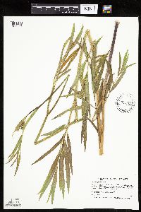 Oxypolis rigidior (L.) Rafinesque 477200[1035451]Smith, Welby 172241990-07-12 United States, Minnesota, Fillmore, Fillmore County ... On the southwest side of State Highway 63, about 6 miles northeast of LeRoy ... T 101N R 13W NW1/4 of NW1/4 of Sec 15. 101N 13W 15, 43.5558319 -92.3866653 |
MIN:Plants |  Oxypolis rigidior (L.) Rafinesque 920343[1035487]Smith, Welby 240251993-09-28 United States, Minnesota, Sherburne, Sand Prairie Wildlife Management Area. Sherburne County ... Sand Prairie State Wildlife Management Area, about 2 miles east-southeasst of St. Cloud ...T35N R30W NE1/4 of SW1/4 of Sec 4. 035N 30W 4, 45.5511111 -94.0811111 |
MIN:Plants |  Oxypolis rigidior (L.) Rafinesque 919604[1035486]Anderson, Derek 13552009-08-18 United States, Minnesota, Steele, Steele County...About 6 km east of Owatonna, on Maple Creek...T107N, R19W, NESW05;;107N;19W;05, 44.0991667 -93.1388889 |
MIN:Plants |  Oxypolis rigidior (L.) Rafinesque 913071[1035493]Anderson, Derek 10562008-08-19 United States, Minnesota, Freeborn, Freeborn County ... About 400 meters north of Manchester, along the railroad right-of-way ... T102N, R22W, NENE15;;102N;22W;15, 43.7280556 -93.4522222 |
MIN:Plants |  Oxypolis rigidior (L.) Rafinesque 919569[1035483]Anderson, Derek 13502009-08-18 United States, Minnesota, Steele, Steele County...About 6.25 km east-southeast of Medford, on a tributary to Medford Creek. About 1 km north of County Road 9...T108N, R20W, SESE13. 108N 20W 13, 44.1561111 -93.1711111 |
MIN:Plants |  Oxypolis rigidior (L.) Rafinesque 919215[1035484]Anderson, Derek 13352009-08-17 United States, Minnesota, Mower, Hormel Nature Center, on the northeast side of Austin. NWNW of section;<No data>;103N;17W;31, 43.6863889 -92.925 |
MIN:Plants |  Oxypolis rigidior (L.) Rafinesque 919583[1035485]Anderson, Derek 13662009-08-25 United States, Minnesota, Steele, Steele County...Beetween Hope and Lemond on County Road 4. About 2.5 km west of County Road 30...T106N R21W SWNE23;;106N;21W;23, 43.9719444 -93.325 |
MIN:Plants |  Oxypolis rigidior (L.) Rafinesque 919099[1035497]Anderson, Derek 13252009-08-04 United States, Minnesota, Dodge, Dodge County...Bud Jensen WMA, about 9 km southeast of Dodge Center, on Salem Creek...T106N R17W NESW25;Bud Jensen Wildlife Management Area;106N;17W;25, 43.9558333 -92.8105556 |
MIN:Plants |  Oxypolis rigidior (L.) Rafinesque 850378[1283565]Stork, H. E. s.n.1925-06-00 United States, Minnesota, Itasca, Bowstring, 47.537188 -93.905046 |
MIN:Plants | 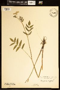 Oxypolis rigidior (L.) Rafinesque 850380[1283566]Stork, H. E. s.n.1925-06-00 United States, Minnesota, Itasca, Bowstring, 47.537188 -93.905046 |
MIN:Plants | 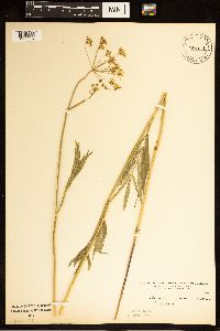 Oxypolis rigidior (L.) Rafinesque 850379[1283567]Kramer, Leona s.n.1927-00-00 United States, Minnesota, Mower, Mower Co., 43.67147 -92.752514 |
MIN:Plants | 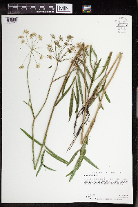 Oxypolis rigidior (L.) Rafinesque 963632[1352247]Graham, Dustin R. DRJG1532018-08-16 United States, Minnesota, Olmsted, Located on the Southwest side of Stewartville, MN., 43.85 -92.47, 1224m |
MIN:Plants | 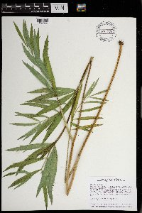 Oxypolis rigidior (L.) Raf. 970763[1394244]Smith, Welby R WRS357032017-06-13 United States, Minnesota, Dodge, 10.6 km (6.6 miles) east of approximate center of the town of Hayfield at heading of 86 degrees., 43.8968056 -92.7145556 |
MIN:Plants | 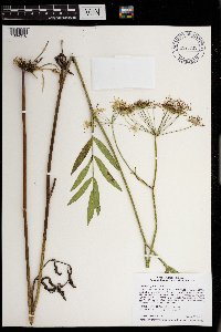 Oxypolis rigidior (L.) Raf. 970835[1394316]Smith, Welby R WRS357832017-08-23 United States, Minnesota, Dakota, In Burnsville, about 3 km (1.9 miles) W-SW of the junction of I35W and I35E., 44.7312306 -93.3191583 |
MIN:Plants | 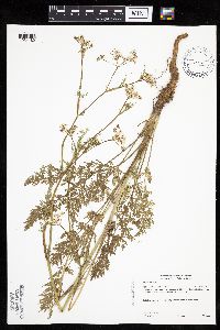 Carum carvi L. 492584[1034189]Gerdes, Lynden 49872005-06-09 United States, Minnesota, Lake, Superior National Forest. T60N R06W S25NENWNW Lake County...Superior National Forest. ENE of Isabella, MN, approximatetly 0.86 miles east of Wilson Lake at intersection of FR 170 and FR 348.. 060N 06W 25, 47.652407 -91.032996 |
MIN:Plants | 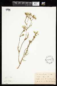 Carum carvi L. 162985[1034209]Wirkrrshrim, W. s.n.1891-06-00 United States, Minnesota, Lincoln, Idlewild [pioneer village in sec. 18 of Ash Lake Township]. Lincoln Co.;;111N;45W;18, 44.42271 -96.31291 |
MIN:Plants | 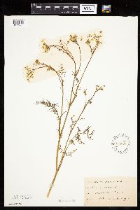 Carum carvi L. 162986[1034204]Moyer, Lycurgus s.n.1885-06-00 United States, Minnesota, Chippewa, Montevideo;;117N;40W;, 44.934626 -95.675774 |
MIN:Plants |  Carum carvi L. 162987[1034201]Frost, W. F1241892-06-00 United States, Minnesota, Meeker, Litchfield;;N;;, 45.127185 -94.528047 |
MIN:Plants |  Carum carvi L. 162988[1034211]Sheldon, Edmund S26101892-06-00 United States, Minnesota, Mille Lacs, Mille Lacs Reservation;Mille Lacs Indian Reservation;N;;, 46.107225 -93.716142 |
MIN:Plants |  Carum carvi L. 162989[1034196]Manning, Sara s.n.1898-05-29 United States, Minnesota, Wabasha, Lake City;;N;;, 44.4081 -92.252454 |
MIN:Plants |  Carum carvi L. 162991[1034220]Bergman, H. s.n.1912-06-22 United States, Minnesota, Becker, Detroit;;N;;, 46.847559 -95.858616 |
MIN:Plants |  Carum carvi L. 162992[1034221]Ballard, C. 28431901-06-05 United States, Minnesota, Clay, Moorhead;;N;;, 46.873852 -96.767581 |
MIN:Plants |  Carum carvi L. 267177[1034217]Anonymous 821912-06-00 United States, Minnesota, Kandiyohi, Willmar;;N;;, 45.121908 -95.043342 |
MIN:Plants |  Carum carvi L. 289412[1034192]Butters, F.; Buell, Murray 3471932-07-08 United States, Minnesota, Cook, near drain from house, Susie Island, T63N, R7E;North Shore / Susie Islands, The Nature Conservancy;063N;07E;, 47.973776 -89.578978 |
MIN:Plants |  Carum carvi L. 300927[1034203]Chandonnet, Z. s.n.1910-06-06 United States, Minnesota, Otter Tail, Perham;;N;;, 46.594404 -95.572542 |
MIN:Plants |  Carum carvi L. 348228[1034200]Moyle, J. s.n.1938-06-10 United States, Minnesota, Carver, roadside near Waconia;;116N;25W;, 44.8476 -93.827753 |
MIN:Plants |  Carum carvi L. 353575[1034199]Lakela, Olga 24871938-06-26 United States, Minnesota, Saint Louis, S19, Duluth;;N;;, 46.783273 -92.106579 |
MIN:Plants |  Carum carvi L. 354044[1034222]Lakela, Olga 25801938-07-23 United States, Minnesota, Saint Louis, 7th Ave W at Skyline Parkway, Duluth;;N;;, 46.78498 -92.11441 |
MIN:Plants |  Carum carvi L. 354588[1034190]Moyle, J. 13141934-07-18 United States, Minnesota, Pennington, Thief River Falls;;N;;, 48.137191 -96.175395 |
MIN:Plants |  Carum carvi L. 359222[1034223]Alaspa, E.; Alaspa, H. s.n.1940-07-15 United States, Minnesota, Carlton, ca 1 1/2 mi S of Scanlon;;N;;, 46.684895 -92.428246 |
MIN:Plants |  Carum carvi L. 370292[1034218]Moore, John; et al. 145061941-06-15 United States, Minnesota, Pennington, beside hwy 59, 1 mi SE of Thief River Falls;;;;, 48.137191 -96.175395 |
MIN:Plants |  Carum carvi L. 381154[1034202]Rosendahl, C.; et al. 75911942-06-17 United States, Minnesota, Winona, Schultz's yard, 2 mi N of Utica;;;;, 44.004486 -91.954879 |
MIN:Plants |  Carum carvi L. 381364[1034226]Moore, John; et al. 154771942-06-20 United States, Minnesota, Dodge, West Concord;;108N;17W;, 44.153161 -92.862109 |
MIN:Plants |  Carum carvi L. 401388[1034208]Butters, F.; et al. 108821939-07-05 United States, Minnesota, Cook, Cook County...upper road, 1 mi E of Grand Portage;Grand Portage Indian Reservation / North Shore;063N;06E;, 47.958468 -89.703576 |
MIN:Plants |  Carum carvi L. 420626[1034191]Lakela, Olga 105551950-06-29 United States, Minnesota, Saint Louis, Congdon River Terrace, below Superior St, Duluth;;N;;, 46.81662 -92.05412 |
MIN:Plants |  Carum carvi L. 440261[1034188]Myhre, K. 38901993-06-22 United States, Minnesota, Pine, Pine Co. Located 2 mi S of Sturgeon Lake. T45N R19W NE1/4 of SW1/4 of Sec 33;;045N;19W;33, 46.338863 -92.751249 |
MIN:Plants |  Carum carvi L. 446141[1034224]Moore, John; et al. 172901945-06-18 United States, Minnesota, Roseau, Roseau County...8 mi S of Roseau;;;;, 48.834515 -95.762766 |
MIN:Plants |  Carum carvi L. 448144[1034183]Gerdes, Lynden; et al. 34781999-06-23 United States, Minnesota, Cook, T65N R02W S19SENE. Cook Co. Superior National Forest. Northeast corner of the most southeastern bay of Gunflint Lake.;Superior National Forest;065N;02W;19, 48.098709 -90.630416 |
MIN:Plants |  Carum carvi L. 448936[1034206]Moore, John; Hall, Robert 163811944-06-09 United States, Minnesota, Pipestone, Pipestone Co.; village of Trosky;;105N;45W;, 43.892269 -96.245863 |
MIN:Plants |  Carum carvi L. 497536[1034212]Moore, John 202161949-06-21 United States, Minnesota, Lake of the Woods, near the mouth of Silver Creek W of Clementson;;N;;, 48.69578 -94.49092 |
MIN:Plants |  Carum carvi L. 531629[1034195]Bergman, H. s.n.1912-06-22 United States, Minnesota, Becker, Detroit;;N;;, 46.847559 -95.858616 |
MIN:Plants |  Carum carvi L. 554413[1034215]Moore, John 232591957-06-17 United States, Minnesota, Martin, 10 mi S of Fairmont;;N;;, 43.507331 -94.461083 |
MIN:Plants |  Carum carvi L. 554414[1034210]Moore, John 231671957-06-12 United States, Minnesota, Pipestone, Pipestone Co.; along rr at Woodstock;;106N;44W;, 43.979244 -96.124437 |
MIN:Plants |  Carum carvi L. 558417[1034205]Moore, John 238531958-06-12 United States, Minnesota, Kittson, along rr at Hallock;;N;;, 48.774426 -96.946447 |
MIN:Plants |  Carum carvi L. 560937[1034207]Ownbey, Gerald 27531959-06-30 United States, Minnesota, Clearwater, Itasca State Park, Biological Station;Itasca State Park;143N;36W;, 47.19557 -95.233216 |
MIN:Plants |  Carum carvi L. 572569[1034225]Moore, John; Baker, Gary 254631961-06-21 United States, Minnesota, Houston, Houston County...near upper end of Winnebago Valley, 3 mi SE of Caledonia;Dorer Memorial Hardwood State Forest;102N;05W;00, 43.630682 -91.431985 |
MIN:Plants |  Carum carvi L. 583263[1034193]Kellner, H. 4401956-07-20 United States, Minnesota, Cook, behind the stockade at Grand Portage;Grand Portage Indian Reservation / North Shore;063N;06E;, 47.958468 -89.703576 |
MIN:Plants |  Carum carvi L. 585337[1034197]Moore, John 262651963-05-22 United States, Minnesota, Blue Earth, 4 mi S of Mankato;;N;;, 44.105644 -93.9994 |
MIN:Plants |  Carum carvi L. 585564[1034216]Moore, John; et al. 260491962-06-08 United States, Minnesota, Houston, Houston County...3 mi SW of Caledonia;;;;, 43.631619 -91.501053 |
MIN:Plants | 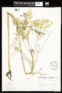 Carum carvi L. 594173[1034214]Thorne, Robert 311741962-07-20 United States, Minnesota, Clearwater, by Ice House Pond, Campus of Univ. of Minnesota Biol. Sta, Itasca State Park;Itasca State Park;143N;36W;, 47.19557 -95.233216 |
MIN:Plants | 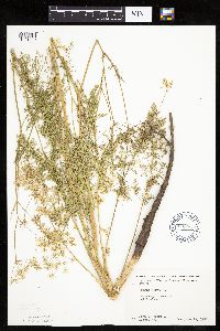 Carum carvi L. 603987[1034219]Moore, John; Hsi, Yu-tseng [Eugene] 272131967-06-19 United States, Minnesota, Winona, Lewiston;;106N;09W;, 43.977067 -91.899115 |
MIN:Plants | 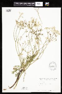 Carum carvi L. 614613[1034198]Westkaemper, Remberta s.n.1969-06-00 United States, Minnesota, Stearns, Stearns Co. School grounds Raymond Twp, Sauk Center;;125N;35W;, 45.628667 -95.077451 |
MIN:Plants | 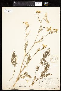 Carum carvi L. 708400[1034194]Manning, Sara s.n.1898-05-29 United States, Minnesota, Wabasha, Lake City;;N;;, 44.4081 -92.252454 |
MIN:Plants | 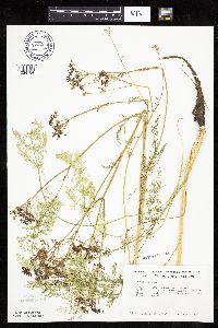 Carum carvi L. 724294[1034184]Smith, Welby 26861980-07-06 United States, Minnesota, Wright, Wright Co.; T121N, R26W, NW1/4 SW1/4 S10; S side of co rd 39, ca 1 1/4 mi WSW of Silver Creek;;121N;26W;10, 45.303961 -93.942892 |
MIN:Plants | 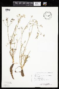 Carum carvi L. 834319[1034185]Monson, Paul 60921984-08-03 United States, Minnesota, Cook, Grand Portage National Monument. Cook Co. R-6E, T-63N, S-4, Visitor Center area;Grand Portage National Monument / North Shore;063N;06E;, 47.958468 -89.703576 |
MIN:Plants | 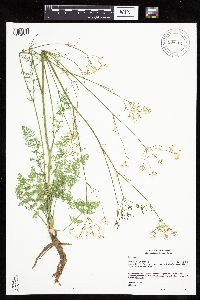 Carum carvi L. 908404[1034227]Gerdes, Lynden 54052007-06-18 United States, Minnesota, Lake, Superior National Forest. T60N R11W S08SWNWNE. Lake County, MN. Superior National Forest. Approximately 8.8 miles ESE of Babbitt, MN. Near the east side of FR 424E.. 060N 11W 8, 47.698978 -91.750445 |
MIN:Plants | 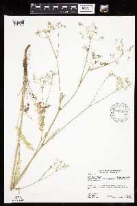 Carum carvi L. 917217[1034213]Gerdes, Lynden 55852008-07-07 United States, Minnesota, Saint Louis, Superior National Forest. T64N R12W S36SESW. St. Louis County, MN. Superior National Forest. Low Lake parking lot. Approximately 3.65 miles NNW of Winton, MN.. 064N 12W 36, 47.9788889 -91.8147222 |
Google Map
Google Maps is a web mapping service provided by Google that features a map that users can pan (by dragging the mouse) and zoom (by using the mouse wheel). Collection points are displayed as colored markers that when clicked on, displays the full information for that collection. When multiple species are queried (separated by semi-colons), different colored markers denote each individual species.