University of Minnesota
http://www.umn.edu/
612-625-5000
http://www.umn.edu/
612-625-5000
Minnesota Biodiversity Atlas
Bell Museum
Dataset: MIN-Plants
Taxa: Bolboschoenus
Search Criteria: excluding cultivated/captive occurrences
Bell Museum plants | |
 MIN:Plants |  Bolboschoenus fluviatilis (Torrey) Soj 841637[1006409]Smith, Welby 133471987-07-07 United States, Minnesota, Washington, Washington Co. Island in the St. Croix River, about 2 mi NE of Scandia; SE1/4 SE1/4 sec.7, T32N R19W;;032N;19W;7, 45.2675018 -92.7555542 |
MIN:Plants |  Bolboschoenus maritimus var. paludosus (A. Nelson) T. Koyama 268468[1006477]Kreuholz, R. 31929-08-14 United States, Minnesota, Yellow Medicine, 4 mi. N of Lake Henricks (W of Canby).;;N;;, 44.7038 -96.35628 |
MIN:Plants |  Bolboschoenus maritimus var. paludosus (A. Nelson) T. Koyama 297225[1006478]Hotchkiss, N.; et al. 39821930-07-23 United States, Minnesota, Lyon, Dennin slough. Lyon Co.;;;;, 44.239648 -95.896874 |
MIN:Plants |  Bolboschoenus maritimus var. paludosus (A. Nelson) T. Koyama 297229[1006470]Hotchkiss, N.; et al. 39871930-07-23 United States, Minnesota, Lyon, Dennin slough. Lyon Co.;;;;, 44.239648 -95.896874 |
MIN:Plants |  Bolboschoenus maritimus var. paludosus (A. Nelson) T. Koyama 338196[1006480]Moyle, J. 23171936-08-11 United States, Minnesota, Big Stone, Big Stone Lake, 6 mi. N of Ortonville.;;N;;, 45.38519 -96.49841 |
MIN:Plants |  Bolboschoenus maritimus var. paludosus (A. Nelson) T. Koyama 346251[1102278]Moyle, J. 32501938-09-23 United States, Minnesota, Swift, Swift Co. Long Lake.;;N;;, 45.282709 -95.681439 |
MIN:Plants |  Bolboschoenus maritimus var. paludosus (A. Nelson) T. Koyama 412464[1006469]Moore, John; Moore, Marjorie 115721939-08-09 United States, Minnesota, Kittson, N line of S. 36, St. Vincent twp.;;163N;50W;36, 48.897907 -97.073696 |
MIN:Plants |  Bolboschoenus maritimus var. paludosus (A. Nelson) T. Koyama 500653[1006476]Harris, S. 4291953-06-30 United States, Minnesota, Marshall, In Mud Lake, Mud Lake National Wildlife Refuge. Plot 21.;Agassiz National Wildlife Refuge;N;;, 48.313302 -96.01363 |
MIN:Plants | 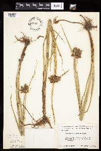 Bolboschoenus maritimus var. paludosus (A. Nelson) T. Koyama 507421[1006472]Moore, John 208161950-09-13 United States, Minnesota, Big Stone, E shore of Big Stone Lake, 6 mi. N of Ortonville.;;N;;, 45.38519 -96.49841 |
MIN:Plants | 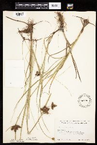 Bolboschoenus maritimus var. paludosus (A. Nelson) T. Koyama 541376[1006483]Scharf, J. s.n.1956-08-31 United States, Minnesota, Murray, 1/2 mi. E of Lake Wilson. On the southern portion of Lake Wilson.;;N;;, 43.996632 -95.94273 |
MIN:Plants | 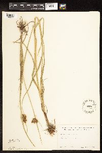 Bolboschoenus maritimus var. paludosus (A. Nelson) T. Koyama 541391[1102276]Scharf, J. s.n.1956-07-27 United States, Minnesota, Redwood, Redwood Co.;;N;;, 44.399019 -95.232147 |
MIN:Plants | 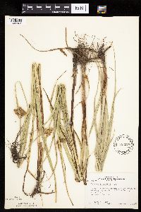 Bolboschoenus maritimus var. paludosus (A. Nelson) T. Koyama 553578[1006485]Moore, John; Heig, V. 240591958-09-09 United States, Minnesota, Kittson, 1 mi. N of Humboldt.;;163N;50W;, 48.93381 -97.128306 |
MIN:Plants |  Bolboschoenus maritimus var. paludosus (A. Nelson) T. Koyama 558122[1006473]Stevens, O. 21681959-08-30 United States, Minnesota, Clay, 1 mi. W of Downer.;;N;;, 46.754125 -96.508145 |
MIN:Plants |  Bolboschoenus maritimus var. paludosus (A. Nelson) T. Koyama 560674[1006479]Ownbey, Gerald; et al. 22641955-07-11 United States, Minnesota, Mahnomen, Mahnomen County...Sullivan Lake E of Waubun, hwy. 113.;White Earth Indian Reservation;;;, 47.194255 -95.869088 |
MIN:Plants |  Bolboschoenus maritimus var. paludosus (A. Nelson) T. Koyama 566514[1006474]Moore, John; Heig, V. 240591958-09-09 United States, Minnesota, Kittson, 1 mi. N of Humboldt.;;163N;50W;, 48.93381 -97.128306 |
MIN:Plants |  Bolboschoenus maritimus var. paludosus (A. Nelson) T. Koyama 573915[1006482]Stevens, O. 24211961-07-03 United States, Minnesota, Clay, Moorhead. Along a railroad.;;139N;48W;, 46.845648 -96.728846 |
MIN:Plants |  Bolboschoenus maritimus var. paludosus (A. Nelson) T. Koyama 628131[1006486]Ownbey, Gerald 46541972-08-17 United States, Minnesota, Mahnomen, Mahnomen Co. Sullivan Lake, Rt. 113, ca. 1 mi E of Waubun. S side of the hwy. Just across the W end of the lake.;White Earth Indian Reservation;N;;, 47.180514 -95.917914 |
MIN:Plants |  Bolboschoenus maritimus var. paludosus (A. Nelson) T. Koyama 689981[1006471]Ownbey, Gerald 58011977-08-11 United States, Minnesota, Mahnomen, Mahnomen Co. S side of Rt. 200, 10 mi E of its jct. with Rt. 59 at Mahnomen. T144N R40W Sec.4 NE1/4 of NW1/4.;White Earth Indian Reservation;144N;40W;4, 47.316812 -95.752842 |
MIN:Plants |  Bolboschoenus maritimus var. paludosus (A. Nelson) T. Koyama 707934[1006464]Smith, Welby 12531979-08-03 United States, Minnesota, Lac Qui Parle, Salt Lake. 3.5 mi. S-SW of Marietta.;Salt Lake Wildlife Management Area;117N;46W;8, 44.957871 -96.443745 |
MIN:Plants |  Bolboschoenus maritimus var. paludosus (A. Nelson) T. Koyama 709319[1006463]Wheeler, Gerald 43111979-07-10 United States, Minnesota, Lac Qui Parle, Salt Lake. Ca. 3 mi. SW of Marietta.;;117W;46W;5, 44.972372 -96.443681 |
MIN:Plants |  Bolboschoenus maritimus var. paludosus (A. Nelson) T. Koyama 789490[1006459]Smith, Welby 112211985-08-15 United States, Minnesota, Lac Qui Parle, Salt Lake Wildlife Management Area, ca. 4 mi. S-SW of Marietta. Along the S shore of Salt Lake.;Salt Lake Wildlife Management Area;117N;46W;8, 44.957871 -96.443745 |
MIN:Plants |  Bolboschoenus maritimus var. paludosus (A. Nelson) T. Koyama 795380[1006462]Dana, R. 870251987-06-13 United States, Minnesota, Clay, Between hwy. 9 and a cultivated field on the E side of the hwy.;;140N;46W;09, 46.9564 -96.495048 |
MIN:Plants |  Bolboschoenus maritimus var. paludosus (A. Nelson) T. Koyama 795537[1006456]Cholewa, A. 14571987-07-23 United States, Minnesota, Clay, Wildlife management area, 4 mi. S of Felton; E side of hwy. 9. At the N end of the WMA.;;141N;46W;22, 47.013438 -96.489328 |
MIN:Plants |  Bolboschoenus maritimus var. paludosus (A. Nelson) T. Koyama 812750[1006465]Wheeler, Gerald 121141988-09-10 United States, Minnesota, Traverse, Traverse Co.; Ca. 17 mi. E of Browns Valley; waterfowl area N of Rte. 2. T 125N R 46W Sec. 32;Geyer Wildlife Management Area;125N;46W;32, 45.592625 -96.479571 |
MIN:Plants |  Bolboschoenus maritimus var. paludosus (A. Nelson) T. Koyama 814613[1006455]Wheeler, Gerald 107021988-06-09 United States, Minnesota, Clay, Ca. 4.5 mi. N-NE of Barnesville; wildlife area N of Rte. 126.;;138N;45W;34, 46.724832 -96.353574 |
MIN:Plants |  Bolboschoenus maritimus var. paludosus (A. Nelson) T. Koyama 814758[1006454]Wheeler, Gerald 115781988-07-28 United States, Minnesota, Big Stone, Ca. 10.5 mi. N of Correll; SW of Rte. 10. NE side of Artichoke Lake.;;122N;44W;14, 45.377147 -96.148127 |
MIN:Plants |  Bolboschoenus maritimus var. paludosus (A. Nelson) T. Koyama 814783[1006468]Wheeler, Gerald 110131988-06-29 United States, Minnesota, Wilkin, Ca. 1.7 mi. W of the jct. of Rte. 55 and 75, N of Rte. 55.;;130N;47W;24, 46.058135 -96.523822 |
MIN:Plants |  Bolboschoenus maritimus var. paludosus (A. Nelson) T. Koyama 815708[1006460]Wheeler, Gerald 117451988-08-15 United States, Minnesota, Norman, Ca. 11 mi. NE of Gary; S of Rte. 107. Along the Sand Hill River (N bank). N1/2 NW1/4 Sec. 11 T146N R43W (Bear Rock Twp Ca. 11 mi. NE of Gary; S of Rte. 107. Along the Sand Hill River (N bank). N1/2 NW1/4 Sec. 11 T146N R43W (Bear Rock Twp.).. 146N 43W 11, 47.481286 -96.097659 |
MIN:Plants |  Bolboschoenus maritimus var. paludosus (A. Nelson) T. Koyama 815788[1006458]Wheeler, Gerald 112721988-07-22 United States, Minnesota, Lac Qui Parle, Ca. 5.5 mi. W-SW of Madison; wildlife area E of Rte. 13. NW1/4 Sec. 33 T118N R45W.;;118N;45W;33, 44.98695 -96.299017 |
MIN:Plants |  Bolboschoenus maritimus var. paludosus (A. Nelson) T. Koyama 816042[1006461]Wheeler, Gerald 122491988-09-20 United States, Minnesota, Traverse, Ca. 1.2 mi. N of the jct. of Rte. 27 and Rte. 28; W of Rte. 27. Along the shore of Lake Traverse (E bank). W1/2 NW1/4 Ca. 1.2 mi. N of the jct. of Rte. 27 and Rte. 28; W of Rte. 27. Along the shore of Lake Traverse (E bank). W1/2 NW1/4 NW1/4 Sec. 28, T125N, R49W, Folsom Twp.. 125N 49W 28, 45.607776 -96.833813 |
MIN:Plants |  Bolboschoenus maritimus var. paludosus (A. Nelson) T. Koyama 83375[1006484]Frost, W. F2641892-07-00 United States, Minnesota, Kandiyohi, Willmar.;;119N;35W;, 45.110139 -95.062995 |
MIN:Plants |  Bolboschoenus maritimus var. paludosus (A. Nelson) T. Koyama 83376[1102277]Ballard, C. 25391900-08-00 United States, Minnesota, Otter Tail, Fergus Falls.;;N;;, 46.283015 -96.077558 |
MIN:Plants | 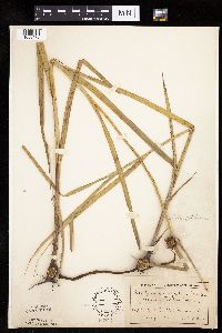 Bolboschoenus maritimus var. paludosus (A. Nelson) T. Koyama 83377[1006475]Ballard, C. 25441900-08-00 United States, Minnesota, Otter Tail, Fergus Falls.;;N;;, 46.283015 -96.077558 |
MIN:Plants | 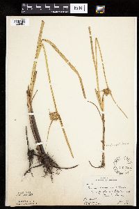 Bolboschoenus maritimus var. paludosus (A. Nelson) T. Koyama 83378[1006481]Butters, F.; et al. 40561921-06-18 United States, Minnesota, Traverse, Lake Traverse.;;;;, 45.69025 -96.745148 |
MIN:Plants | 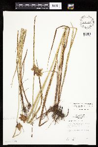 Bolboschoenus maritimus var. paludosus (A. Nelson) T. Koyama 835510[1006467]Monson, Paul 44321961-07-10 United States, Minnesota, Mahnomen, Mahnomen Co. R-41, T-143, SE corner S-21 & SW corner S-22; along Hwy.133, 3 mi E of Waubun.;White Earth Indian Reservation;143N;41W;, 47.194255 -95.869088 |
MIN:Plants | 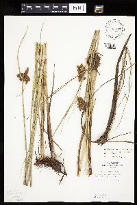 Bolboschoenus maritimus var. paludosus (A. Nelson) T. Koyama 836118[1006466]Monson, Paul 44401961-07-10 United States, Minnesota, Mahnomen, Mahnomen Co. R-41 T-145 S-20. Rush Lake;White Earth Indian Reservation;145N;41W;20, 47.361459 -95.900997 |
MIN:Plants |  Bolboschoenus maritimus var. paludosus (A. Nelson) T. Koyama 567156[1006489]Hunnewell, F. 108331928-08-10 United States, Utah, Washington, Washington County ... Zion Canyon;Zion National Park, 1250m |
MIN:Plants |  Bolboschoenus fluviatilis (Torrey) Soj 907764[1006382]Smith, Welby 311122008-08-13 United States, Minnesota, Le Sueur, Diamond Lake Wildlife Management Area. Le Sueur County ...Diamond Lake State Wildlife Management Area, about 0.5 mile north of Kilkenny ...T110N R23W SW1/4 of NE1/4 of Sec 22. 110N 23W 22, 44.3219444 -93.5719444 |
MIN:Plants |  Bolboschoenus robustus (Pursh) Soj 251504[1006492]Brainerd, E. s.n.1879-08-23 United States, Massachusetts, Barnstable, Cape Cod;Cape Cod National Seashore |
MIN:Plants |  Bolboschoenus maritimus var. paludosus (A. Nelson) T. Koyama 680318[1006490]Bright, R. 74-2301974-09-29 United States, Idaho, Franklin, Franklin Co. ... near old Del Rio Swimming pool and hot springs, 3 miles west of Preston., 1372m |
MIN:Plants |  Bolboschoenus fluviatilis (Torrey) Soj 896973[1006407]Smith, Welby 156891989-07-13 United States, Minnesota, Kanabec, Kanabek [sic] County...Along the north side of Mud Lake (Quamba Lake), about one mile south of Quamba... NW1/4 NE1/4 section 2, T 39N R 23W. 039N 23W 2, 45.897248 -93.173466 |
MIN:Plants |  Bolboschoenus fluviatilis (Torrey) Soj 477280[1006412]Myhre, K. 68341997-07-04 United States, Minnesota, Morrison, Morrison County ... Sullivan Lake. Located 15 miles northeast of the town Pierz. Plants occur along the north bay of the lake ... T 42N R 29W SW1/4 of NE1/4 of Sec 1. 042N 29W 1, 46.149496 -93.946975 |
MIN:Plants |  Bolboschoenus maritimus var. paludosus (A. Nelson) T. Koyama 443465[1102275]Bright, R. 73-2871973-00-00 United States, Idaho, Franklin, [no further data] |
MIN:Plants |  Bolboschoenus fluviatilis (Torrey) Soj 922195[1102269]Morantes, A.; et al. AFM2102009-08-06 United States, Minnesota, Saint Louis, Superior National Forest. Superior National Forest. Growing in St. Louis River...Easting: 567,141 Northing: 5,254,960 T 57N R 14W Sec SW3. 057N 14W 3, 47.4447222 -92.1094444 |
MIN:Plants |  Bolboschoenus fluviatilis (Torrey) Soj 934132[1102274]Smith, Welby R. 335652011-09-14 United States, Minnesota, Faribault, About 2 miles east of Winnebago. SE of NE of section;Rice Lake Wildlife Management Area;104N;27W;31, 43.7675667 -94.1077167 |
MIN:Plants |  Bolboschoenus fluviatilis (Torrey) Soj 935483[1102257]Smith, Welby R. 330932011-07-27 United States, Minnesota, Sherburne, On the west side of Zimmerman. SE of SE of section;Fremont Wildlife Management Area;034N;26W;18, 45.43 -93.6166106 |
MIN:Plants |  Bolboschoenus fluviatilis (Torrey) Soj 936099[1102256]Smith, Welby R. 324882011-06-09 United States, Minnesota, Sherburne, on the west side of Zimmerman. SE of SE of section;Fremont State Wildlife Management Area;034N;26W;18, 45.43 -93.6166106 |
MIN:Plants |  Bolboschoenus fluviatilis (Torrey) Soj 936798[1106786]Smith, Welby R. 297282006-07-27 United States, Minnesota, Pipestone, About 14 miles northeast of Pipestone (town). SE of SW of section;Woodstock Wildlife Management Area;107N;44W;01, 44.0976524 -96.0778851 |
MIN:Plants |  Bolboschoenus fluviatilis (Torrey) Soj 936812[1106785]Smith, Welby R. 297562006-08-03 United States, Minnesota, Chippewa, Along the southwest shore of Watson Sag. NW of NW of section;Lac Qui Parle Wildlife Management Area;118N;41W;08, 45.0487251 -95.8345794 |
MIN:Plants |  Bolboschoenus fluviatilis (Torrey) Soj 936830[1106784]Smith, Welby R. 297892006-08-11 United States, Minnesota, Goodhue, North Lake in the Mississippi River bottoms, about 9 miles southeast of Hastings.;;114N;16W;22, 44.66546 -92.722507 |
MIN:Plants |  Bolboschoenus fluviatilis (Torrey) Soj 936953[1106787]Smith, Welby R. 302332007-07-11 United States, Minnesota, Marshall, NW of NE of section;Agassiz National Wildlife Refuge;156N;41W;36, 48.2927902 -95.8587815 |
MIN:Plants |  Bolboschoenus fluviatilis (Torrey) Soj 722541[1102273]Smith, Welby R. 296032006-06-16 United States, Minnesota, Polk, About 6 miles northeast of Fosston. NW of NW of section;Tilberg County Park;148N;39W;21, 47.627498 -95.6348191 |
MIN:Plants |  Bolboschoenus fluviatilis (Torrey) Soj 538815[1102272]Smith, Welby R. 296382006-07-05 United States, Minnesota, Steele, About 6 miles northwest of Owatonna. SE of NW of section;Swan Lake Wildlife Management Area;108N;21W;34, 44.1196395 -93.3407073 |
MIN:Plants |  Bolboschoenus fluviatilis (Torrey) Soj 97664[1102271]Smith, Welby R. 296602006-07-10 United States, Minnesota, Waseca, At Reese Lake, about 6 miles west-northwest of Ellendale. NE of NW of section;Teal Wildlife Management Area;105N;22W;24, 43.8888984 -93.4205039 |
MIN:Plants |  Bolboschoenus fluviatilis (Torrey) Soj 405111[1102270]Smith, Welby R. 296692006-07-11 United States, Minnesota, Faribault, About 20 miles west of Albert Lea. SE of SE of section;Walnut Wildlife Management Area;102N;24W;01, 43.6616048 -93.6522241 |
MIN:Plants |  Bolboschoenus fluviatilis (Torrey) Soj 937616[1106783]Gerdes, Lynden B.; Bach, Melissa J. 65672012-06-24 United States, Minnesota, Lake, South Kawishiwi River. Approximately 12.77 miles east of Ely, MN and 1.33 miles southwest of the portage landing between Triangle Lake and the river.;Boundary Waters Canoe Area Wilderness / Superior National Forest;063N;10W;26, 47.907778 -91.566111 |
MIN:Plants |  Bolboschoenus fluviatilis (Torrey) Soj 388943[1118885]Smith, Welby R. 298112006-08-17 United States, Minnesota, Cottonwood, Sandy beach at the east end of Bingham Lake, about 8 miles north of Windom. NE of NE of section;;105N;35W;09, 43.9178459 -95.0427608 |
MIN:Plants |  Bolboschoenus fluviatilis (Torrey) Soj 455277[1118886]Smith, Welby R. 298292006-08-18 United States, Minnesota, Watonwan, South end of Sulem Lake, about 3.5 miles southwest of Butterfield. NW1/4 of SW1/4 of section;;105N;33W;05, 43.925 -94.8355556 |
MIN:Plants |  Bolboschoenus fluviatilis (Torrey) Soj 138512[1118884]Smith, Welby R. 298882006-09-06 United States, Minnesota, Scott, In the Minnesota River bottoms just west of Savage. SE of SE of section;;115N;22W;01, 44.7925242 -93.4024204 |
MIN:Plants |  Bolboschoenus fluviatilis (Torrey) Soj 943332[1290015]Holmstrom, Rebecca RMH #02412013-08-07 United States, Minnesota, Saint Louis, Lake Vermilion. Eastern shore of Wolf Bay approximately 4.3 km northeast of the Oak Narrows public access.; T063N R17W sec13, 47.94198 -92.44058 |
MIN:Plants |  Bolboschoenus fluviatilis (Torrey) Soj 943033[1291080]Smith, Welby R. 347772013-08-10 United States, Minnesota, Wright, In a federal Watrfowl Production Area, about 4.5 km (2.8 miles) W-SW of Howard Lake (town). NE of SW of section; T118N R27W sec07, 45.0428 -94.1268 |
MIN:Plants |  Bolboschoenus fluviatilis (Torrey) Soj 943024[1291088]Smith, Welby R. 347672013-08-08 United States, Minnesota, Goodhue, About 2.3 km (1.4 miles) northwest of Zumbrota. NW of NW of section; T110N R16W sec25, 44.3098833 -92.6879833 |
MIN:Plants |  Bolboschoenus fluviatilis (Torrey) Soj 942917[1291187]Smith, Welby R. 345532013-07-02 United States, Minnesota, Redwood, Delhi State Wildlife Management Area, about 2.2 km (1.3 miles) northwest of the approximate center of Redwood Falls. SE of SW of section; T113N R36W sec25, 44.55605 -95.13145 |
MIN:Plants |  Bolboschoenus fluviatilis (Torrey) Soj 942909[1291195]Smith, Welby R. 345452013-07-02 United States, Minnesota, Redwood, Luescher-Barnum State Wildlife Management Area, about 11.5 km (7 miles) S-SW of Redwood Falls. SE of NW of section; T111N R36W sec04, 44.4499833 -95.18315 |
MIN:Plants |  Bolboschoenus fluviatilis (Torrey) Soj 942908[1291196]Smith, Welby R. 345442013-07-02 United States, Minnesota, Redwood, Willow Lake State Wldlife Management Area, on the norheast side of the town of Wanda. SW of NW of section; T110N R36W sec20, 44.3212 -95.2067833 |
MIN:Plants |  Bolboschoenus fluviatilis (Torrey) Soj 942868[1291049]Smith, Welby R. 345012013-06-21 United States, Minnesota, Nobles, Groth State Wildlife Management Area, about 8 km (5 miles) east of Wilmont. NE of NW of section; T103N R41W sec02, 43.7591333 -95.7278833 |
MIN:Plants |  Bolboschoenus fluviatilis (Torrey) Soj 947900[1292331]Smith, Welby R. 305222007-08-09 United States, Minnesota, Lyon, On the east side of a small lake, about 2 miles north of Taunton. NW of NW of section; T113N R43W sec05, 44.6279583 -96.069404 |
MIN:Plants |  Bolboschoenus fluviatilis (Torrey) Soj 953238[1291742]Knight, Mary s.n.2016-08-16 United States, Minnesota, Marshall, Thief Lake Wildlife Management Area, Thief Lake, MPCA wetland monitoring site 16MARS313, 48.503945 -95.944818 |
MIN:Plants |  Bolboschoenus fluviatilis (Torrey) Soj 956069[1295893]Smith, Welby R. 35222 United States, Minnesota, Swift |
MIN:Plants |  Bolboschoenus fluviatilis (Torrey) Soj 950259[1296782]Smith, Welby R. 33739 United States, Minnesota, Cottonwood |
MIN:Plants |  Bolboschoenus fluviatilis (Torrey) Soj 946035[1296750]Smith, Welby R. 34651 United States, Minnesota, Renville |
MIN:Plants |  Bolboschoenus fluviatilis (Torrey) Soj 952043[1297035]Smith, Welby R. 349072014-06-17 United States, Minnesota, Yellow Medicine |
MIN:Plants | 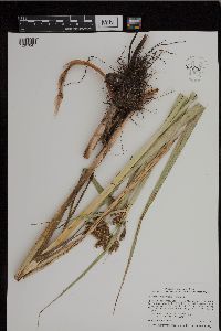 Bolboschoenus fluviatilis (Torrey) Soj 952055[1297047]Smith, Welby R. 349202014-06-18 United States, Minnesota, Yellow Medicine |
MIN:Plants | 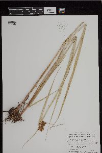 Bolboschoenus maritimus subsp. paludosus (A. Nelson) T. Koyama 952057[1297099]Smith, Welby R. 34922 United States, Minnesota, Yellow Medicine |
MIN:Plants | 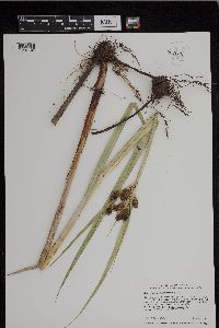 Bolboschoenus fluviatilis (Torrey) Soj 952065[1297107]Smith, Welby R. 34930 United States, Minnesota, Lac Qui Parle |
MIN:Plants | 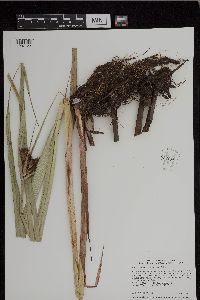 Bolboschoenus fluviatilis (Torrey) Soj 952081[1297123]Smith, Welby R. 34946 United States, Minnesota, Kandiyohi |
MIN:Plants |  Bolboschoenus fluviatilis (Torrey) Soj 952155[1297282]Smith, Welby R. 350692014-07-02 United States, Minnesota, Kandiyohi |
MIN:Plants |  Bolboschoenus fluviatilis (Torrey) Soj 949807[1297514]Smith, Welby R. 33674 United States, Minnesota, Freeborn |
MIN:Plants |  Bolboschoenus fluviatilis (Torrey) Soj 950226[1297545]Smith, Welby R. 33706 United States, Minnesota, Blue earth |
MIN:Plants |  Bolboschoenus fluviatilis (Torrey) Soj 962977[1346574]Whitfeld, T.J.S. 23912019-08-27 United States, Minnesota, Aitkin, US Army Corps of Engineers Big Sandy Lake Recreation Area, campground-marsh, 46.786395 -93.316545 |
MIN:Plants |  Bolboschoenus fluviatilis (Torrey) Soj 959177[1305385]Smith, Welby R. WRS353402015-06-28 United States, Minnesota, Hennepin, Crow-Hassan Regional Park, about 3 km (1.9 miles) southeast of St. Michael., 45.19035 -93.6417333 |
MIN:Plants |  Bolboschoenus fluviatilis (Torrey) Soj 963766[1352653]Welby R Smith 356052016-07-01 United States, Minnesota, St. Louis, In a bed of emergent vegtation on the downstream side of an island in the St. Louis River, just south of New Duluth. SW of SW of section, 46.6525278 -92.2330278 |
MIN:Plants |  Bolboschoenus robustus (Pursh) Soj 968050[1368703]Timothy J. S. Whitfeld 14832016-09-25 United States, Rhode Island, Providence, Siliman Cove, east of intersection of Chiswick Road and Naragansett Blvd., 41.7703583 -71.3900194 |
MIN:Plants |  Bolboschoenus maritimus subsp. paludosus (A. Nelson) T. Koyama 0968739[1391337]Matthews, W.A. 26771927-07-20 United States, New York, Cayuga |
MIN:Plants |  Bolboschoenus maritimus (L.) Palla 0968745[1391343]Matthews, W.A. 28401928-08-17 United States, New York, Monroe |
MIN:Plants | Bolboschoenus fluviatilis (Torrey) Soj []Timothy J. S. Whitfeld 33422022-07-06 United States, Minnesota, Swift, Fairfield 21-1 Native Prairie Bank, 7.8 miles north-north west of Holloway, 45.35837 -95.949446, 309m |
MIN:Plants | Bolboschoenus fluviatilis (Torrey) Soj []Gernes, Mark 2022-06-15 United States, Minnesota, Stevens, Lee Wildlife Protection Area; Site ID: 21STEV142; Visit Number: 2628, 45.46802621 -96.075014 |
MIN:Plants | Bolboschoenus fluviatilis (Torrey) Soj []Gernes, Mark 2022-06-15 United States, Minnesota, Traverse, Site ID: 21TRAV524; Visit Number: 2633, 45.6245226 -96.76987656 |
MIN:Plants |  Bolboschoenus fluviatilis (Torrey) Soj 973391[1398944]Lee, Michael MDL56652011-07-29 United States, Minnesota, Lake, Boundary Waters Canoe Area Wilderness; Strongly rolling bedrock terrain south of Basswood Lake, 12 miles northeast of Ely. Locally common on the shore at the western end of Good Lake., 48.00247025 -91.62464467, 396m |
MIN:Plants |  Bolboschoenus fluviatilis (Torrey) Soj 973393[1398946]Lee, Michael MDL57162011-08-27 United States, Minnesota, Lake, Boundary Waters Canoe Area Wilderness; Rugged bedrock terrain along the Canadian border, 35 miles east-northeast of Ely. In the South Arm of Knife Lake, near a campsite on the point north of the portage to Sema Lake., 48.09403164 -91.15332751, 421m |
MIN:Plants |  Bolboschoenus fluviatilis (Torrey) Soj 973699[1397254]Bezanson, Char A. 1821991-07-15 United States, Minnesota, Rice, in the Thomas West Unit of the Cannon River Wildlife Management Area. North of railroad grade and Highway 60, 1.8 miles northeast of Morristown, 44.243963 -93.41028 |
MIN:Plants | 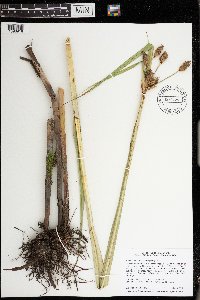 Bolboschoenus fluviatilis (Torrey) Soj 974554[1396918]Smith, Welby R WRS363702019-07-16 United States, Minnesota, McLeod, Phasianus Waterfowl Production Area. Just SE of the junction of 140th street and Nature Avenue, about 2 km (1.3 miles) SW of Biscay., 44.81573 -94.29491 |
MIN:Plants | 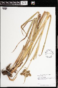 Bolboschoenus fluviatilis (Torrey) Soj 974678[1397445]Dunevitz, Hannah L. 4151990-08-15 United States, Minnesota, Goodhue, 6.5 miles northeast of Kenyon, 0.2 miles west of the Little Cannon River., 44.36 -92.93 |
Google Map
Google Maps is a web mapping service provided by Google that features a map that users can pan (by dragging the mouse) and zoom (by using the mouse wheel). Collection points are displayed as colored markers that when clicked on, displays the full information for that collection. When multiple species are queried (separated by semi-colons), different colored markers denote each individual species.