University of Minnesota
http://www.umn.edu/
612-625-5000
http://www.umn.edu/
612-625-5000
Minnesota Biodiversity Atlas
Bell Museum
Dataset: MIN-Plants
Taxa: Boraginaceae
Search Criteria: excluding cultivated/captive occurrences
Bell Museum plants | |
 MIN:Plants | Hackelia virginiana (L.) I.M. Johnston 657154[]Scanlan, M. 671973-06-13 United States, Minnesota, Swift, Swift Co. Coll. in SW-201 (Sec.19 T122N R39W).;;122N;39W;19, 45.3617284 -95.6135646 |
MIN:Plants | Hackelia virginiana (L.) I.M. Johnston 670654[]Heitlinger, M. 6371972-07-23 United States, Minnesota, McLeod, Schaefer Prairie; SE1/4 of SEc.34 T115N R29W; along Buffalo Creek.;Schaefer Prairie, The Nature Conservancy;115N;29W;34, 44.7250496 -94.3049103 |
MIN:Plants | Hackelia virginiana (L.) I.M. Johnston 697763[]Ownbey, Gerald 53951976-08-29 United States, Minnesota, Washington, T28N R20W SE1/4 Sec.26, ca. 1.3 mi SE of Afton village along St. Croix River where railway trestle crosses dry stream be T28N R20W SE1/4 Sec.26, ca. 1.3 mi SE of Afton village along St. Croix River where railway trestle crosses dry stream bed.. 028N 20W 26, 44.8826273 -92.7757006 |
MIN:Plants | Hackelia virginiana (L.) I.M. Johnston 701146[]Dorio, J. 5671977-07-16 United States, Minnesota, Stearns, Stearns Co. Partch woods, 4.5 mi NW of St. Joseph. Co. rd 3. T125N R29W Sec.19.;Partch Woods Scientific Natural Area;125N;29W;19, 45.6228979 -94.3771346 |
MIN:Plants | Hackelia virginiana (L.) I.M. Johnston 712073[]Smith, Welby 16031979-08-20 United States, Minnesota, Wright, Wright Co.; T121N R27W SW1/4 sec.9; in vacant lot between state hwy 24 and Clearwater Lake.;;121N;27W;9, 45.3165235 -93.8195109 |
MIN:Plants | Hackelia virginiana (L.) I.M. Johnston 721172[]Lustig, K. 7931979-07-26 United States, Minnesota, Sherburne, Clear Lake - Mississippi Scenic and Recreational River, SNA: 12 mi SE of St. Cloud, Sec. 14, 22, 23 T34N R30W.;Clear Lake Scientific Natural Area;T034N R30W T14, 45.436216 -94.037239 |
MIN:Plants | Hackelia virginiana (L.) I.M. Johnston 727874[]Lustig, K. 8071979-08-08 United States, Minnesota, Sherburne, Mississippi River Islands Scientific Natural Area. Sherburne & Wright Cos. ...Mississippi Scenic and Recreational River Islands SNA: Mississippi River Islands between Monticello and Elk River, Sec. 2, 3, 4, T32N R26, 27W; Sec.7, 9, 18, T121N R23, 24W.. 032N 26W 3, 45.297375 -93.667929 |
MIN:Plants | Hackelia virginiana (L.) I.M. Johnston 732753[]Heidel, B. 851981-07-21 United States, Minnesota, Winona, Whitewater State Park.;Whitewater State Park;N;;, 44.055336 -92.05019 |
MIN:Plants | Hackelia virginiana (L.) I.M. Johnston 735577[]Benson, Douglas 3371981-07-27 United States, Minnesota, Wilkin, E-central NE1/4 SE1/4 S.9. Anna Gronseth Prairie: T134N R45W.;Anna Gronseth Prairie, The Nature Conservancy;134N;45W;9, 46.4348561 -96.3542192 |
MIN:Plants | Hackelia virginiana (L.) I.M. Johnston 739731[]Converse, C. 19341982-08-07 United States, Minnesota, Douglas, Staffanson Prairie: T127N R40W NW1/4 NE1/4 and NE1/4 NW1/4 of Sec.18.;Staffanson Prairie, The Nature Conservancy;127N;40W;18, 45.810665 -95.748005 |
MIN:Plants | Hackelia virginiana (L.) I.M. Johnston 770600[]Smith, Welby 84251983-07-26 United States, Minnesota, Mower, Lake Louise State Park, about 1/5 mi NW of LeRoy. N bank of the Iowa River. NE1/4 NW1/4 sec.28 T101N R14W.;Lake Louise State Park;101N;14W;28, 43.5220987 -92.5189584 |
MIN:Plants | Hackelia virginiana (L.) I.M. Johnston 782321[]Tenney, M. 4321982-07-15 United States, Minnesota, Fillmore, Forestville State Park. Fillmore Co. T102N R11W Sec.7 NW1/4 NE1/4 SE1/4.;Forestville State Park;102N;11W;7, 43.652307 -92.199253 |
MIN:Plants |  Hackelia virginiana (L.) I.M. Johnston 796008[1348604]Smith, Welby 112291985-08-25 United States, Minnesota, Ramsey, Ramsey Co.; Crosby Farm Park in St. Paul; on the Mississippi River bottoms. NW1/4 NW1/4 sec. 23 T 28N R 23W.;Hidden Falls - Crosby Farm Regional Park;028N;23W;23, 44.903143 -93.143948 |
MIN:Plants | Hackelia virginiana (L.) I.M. Johnston 801013[]Smith, Welby 124451986-08-11 United States, Minnesota, Goodhue, Goodhue County...Hay Creek Recreation Area, about 2 mi S of Red Wing. NE1/4 NE1/4 sec.12 T112N R15W;Dorer Memorial Hardwood State Forest;112N;15W;12, 44.5247231 -92.5538864 |
MIN:Plants | Hackelia virginiana (L.) I.M. Johnston 805718[]Almendinger, J. MO-003-21987-07-17 United States, Minnesota, Washington, Afton State Park, Afton, T27N R20W NE1/4 NW1/4 of sec.3, just NW of bridge over gully, Trout Brook; 7 mi S town;Afton State Park;027N;20W;3, 44.8549031 -92.7913367 |
MIN:Plants | Hackelia virginiana (L.) I.M. Johnston 814622[]Wheeler, Gerald 110971988-07-16 United States, Minnesota, Traverse, Browns Valley (NE side); W of rt. 2. NW1/4 NW1/4 Sec.34 T125N R49W (Folsom Twp).;;125N;49W;34, 45.5933085 -96.813211 |
MIN:Plants | Hackelia virginiana (L.) I.M. Johnston 814681[]Wheeler, Gerald 113681988-07-25 United States, Minnesota, Lac Qui Parle, Lac Qui Parle State Park. Ca. 15 mi E of Madison; Lac Qui Parle State Park, N of rt. 33; bordering Lac Qui Parle River; N1/2 NE1/4 Sec.23 T118N R4 Ca. 15 mi E of Madison; Lac Qui Parle State Park, N of rt. 33; bordering Lac Qui Parle River; N1/2 NE1/4 Sec.23 T118N R42W (Lac Qui Parle Twp.). 118N 42W 23, 45.016154 -95.888369 |
MIN:Plants |  Hackelia virginiana (L.) I.M. Johnston 816388[1348601]Bender, J. s.n.1986-06-16 United States, Minnesota, Washington, Belwin Outdoor Education Laboratory, T28N R20W S10.;Belwin Outdoor Education Laboratory;028N;20W;10, 44.9271878 -92.7918522 |
MIN:Plants | Hackelia virginiana (L.) I.M. Johnston 817798[]Clem, K. 311990-08-29 United States, Minnesota, Anoka, Springbrook Nature Center, two mile trail. Between University Ave. & East river road on 85th Ave, Fridley.;<No data>;030N;24W;, 45.121798 -93.273541 |
MIN:Plants |  Hackelia virginiana (L.) I.M. Johnston 834236[1348598]Smith, Welby 198561991-07-31 United States, Minnesota, Todd, Grey Eagle Wildlife Management Area. Todd Co. Grey Eagle State Wildlife Management Area, about 4 mi W of Grey Eagle; T127N R33W SW1/4 of SE1/4 of Sec 9 Todd Co. Grey Eagle State Wildlife Management Area, about 4 mi W of Grey Eagle; T127N R33W SW1/4 of SE1/4 of Sec.9. 127N 33W 9, 45.8202782 -94.8366699 |
MIN:Plants |  Hackelia virginiana (L.) I.M. Johnston 839173[1348599]Smith, Welby 176841990-08-02 United States, Minnesota, Dodge, Dodge Co. About 1/2 mi E of Mantorville. Steep N-facing slope overlooking the South Branch Middle Fork Zumbro River; Dodge Co. About 1/2 mi E of Mantorville. Steep N-facing slope overlooking the South Branch Middle Fork Zumbro River; T107N R16W NE1/4 of NE1/4 of Sec 21.. 107N 16W 21, 44.0630569 -92.7416687 |
MIN:Plants | 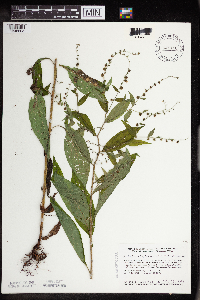 Hackelia virginiana (L.) I.M. Johnston 841110[1348603]Smith, Welby 134781987-07-13 United States, Minnesota, Scott, Murphy-Hanrahan County Park Reserve. Scott County...Murphy-Hanrahan Regional Park, on the S side of Hanrahan Lake, about 2 mi W of Burnsville SW1/4 NW1/4 sec. 34, T115N R21W. 115N 21W 34, 44.7277778 -93.3363889 |
MIN:Plants | Hackelia virginiana (L.) I.M. Johnston 896876[]Haferman, J. 2571996-07-10 United States, Minnesota, Scott, SCOTT CO. T115N R22W S36 SW of SW. Approximately 0.1 miles north-northeast of intersection of State Highway 13 and County Road 44 on north side of highway.. 115N 22W 36, 44.7245862 -93.4090306 |
MIN:Plants | Hackelia virginiana (L.) I.M. Johnston 915943[]Smith, Welby 224351993-06-18 United States, Minnesota, Grant, Grant County...On the south side of Ask Lake, about 1.5 miles east-southest of Ashby...T 130N R 41W NW1/4 of SW1/4 of Sec 12. 130N 41W 12, 46.0847222 -95.7886111 |
MIN:Plants | Hackelia virginiana (L.) I.M. Johnston 498967[]Juhnke, C. 438 CMJ FRO1999-07-13 United States, Minnesota, Goodhue, Frontenac State Park Goodhue County ... Along trail to Sand Point 80 meters beyond bridge ... T112N R13W NW NW NE 13;Frontenac State Park;112N;13W;13, 44.5053595 -92.3190924 |
MIN:Plants | Hackelia virginiana (L.) I.M. Johnston 906877[]Smith, Welby 312322008-08-20 United States, Minnesota, Marshall, Marshall County...Old Mill State Park about 4 mi east-northeast of Alma...T156N R46W SW1/4 of NE1/4 of Sec 4;Old Mill State Park;156N;46W;04, 48.3655556 -96.5722222 |
MIN:Plants | Hackelia virginiana (L.) I.M. Johnston 920475[]Smith, Welby 257991995-08-01 United States, Minnesota, Kandiyohi, Kandiyohi County ... Sibley State Park, about 5 miles west of New London ... T121N R35W SW1/4 of NE1/4 of Sec 1;Sibley State Park;121N;35W;01, 45.32 -95.0161111 |
MIN:Plants | Hackelia virginiana (L.) I.M. Johnston 920483[]Smith, Welby 235061993-08-10 United States, Minnesota, Murray, Murray County ... Lake Shetek State Park, about 3 miles northwest of Currie ... T107N R40W NW1/4 of NW1/4 of Sec 6;Lake Shetek State Park;107N;40W;06, 44.1061111 -95.7005556 |
MIN:Plants | Hackelia virginiana (L.) I.M. Johnston 920308[]Smith, Welby 239651993-09-16 United States, Minnesota, Brown, Brown County...Flandrau State Park, about one mile south of New Ulm...T110N R30W NW1/4 of SE1/4 of Sec 32;Flandrau State Park;110N;30W;34, 44.2877778 -94.4611111 |
MIN:Plants | 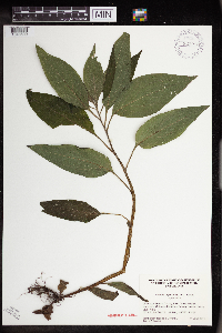 Hackelia virginiana (L.) I.M. Johnston 923918[1348600]Jacobs, Tamberlain; Liu, O. s.n.2011-06-11 United States, Minnesota, Dakota, Inver Grove Heights, Macalester College's Katherine Ordway Natural History Study Area.;;027N;22W;22, 44.81187 -93.03436 |
MIN:Plants | Hackelia virginiana (L.) I.M. Johnston 923950[]Anderson, Derek 12632009-07-22 United States, Minnesota, Freeborn, South side of Albert Lea Lake, south of County Road 19. About 10 km southeast of the city of Albert Lea. NWNW of section;Albert Lea Wildlife Management Area;102N;20W;30, 43.6130128 -93.2862033 |
MIN:Plants | Hackelia virginiana (L.) I.M. Johnston 923846[]Smith, Welby 236891993-08-27 United States, Minnesota, Sibley, About 2.5 miles N-NW of Henderson; in Valley of High Island Creek ca. 2.5 miles SW of its confluence with the Minn[esota] River. NE1/4 of SW1/4 of section.;Vale Wildlife Management Area;113N;26W;27, 44.5625 -93.9427778 |
MIN:Plants | Hackelia virginiana (L.) I.M. Johnston 923321[]Smith, Welby 216341992-08-26 United States, Minnesota, Nicollet, About 7 miles north of Mankato; bank of Seven Mile Creek. NW1/4 of NE1/4 of section.;Seven Mile Creek County Park;109N;27W;11, 44.2680556 -94.0344444 |
MIN:Plants | Hackelia virginiana (L.) I.M. Johnston 922685[]Smith, Welby 235331993-08-11 United States, Minnesota, Isanti, about 13 miles southwest of Cambridge. NW1/4 of SW1/4 of Sec;Lyndon Cedarglade County Park;034N;25W;13, 45.4377778 -93.4075 |
MIN:Plants | Hackelia virginiana (L.) I.M. Johnston 922944[]Smith, Welby 237321993-08-27 United States, Minnesota, McLeod, Lake Marion County Park. Lake Marion County Park; on the south side of Lake Marion, about 6 miles south of Hutchinson... T 115N R 30W NE1/4 of NE1/4 of Sec 12. 115N 30W 12, 44.7877778 -94.3811111 |
MIN:Plants | Hackelia virginiana (L.) I.M. Johnston 922154[]Smith, Welby 232741993-08-03 United States, Minnesota, Renville, in the Minnesota Valley about 4 miles southwest of Sacred Heart. SW1/4 of SE1/4 of Sec;Skalbakken County Park;115N;38W;27, 44.7338889 -95.4097222 |
MIN:Plants | Hackelia virginiana (L.) I.M. Johnston 929697[]Smith, Welby 161901989-08-23 United States, Minnesota, Nobles, West Grahm Lake, about one mile southwest of Kinbrae. NW of SW of section;;104N;39W;15, 43.8086111 -95.5105556 |
MIN:Plants | Hackelia virginiana (L.) I.M. Johnston 930041[]Smith, Welby 159991989-07-31 United States, Minnesota, Kanabec, About 4 miles north of Ogilvie. NW1/4 of SW1/4 of section;Ann Lake Wildlife Management Area;039N;25W;02, 45.8944444 -93.4308333 |
MIN:Plants | Hackelia virginiana (L.) I.M. Johnston 934925[]Whitfeld, T. J. S.; et al. 7652011-09-09 United States, Minnesota, Washington, [no further data];Warner Nature Center;;;, 45.04 -92.89 |
MIN:Plants | 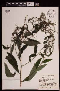 Hackelia virginiana (L.) I.M. Johnston 953237[1291741]Gernes, Mark C. s.n.2016-08-03 United States, Minnesota, Norman, Approx. 14 miles northeast of Ada, MPCA wetland monitoring site 16NORM273, 47.43004 -96.268373 |
MIN:Plants | 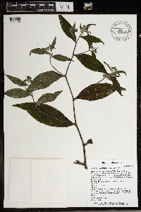 Hackelia virginiana (L.) I.M. Johnston 966270[1359109]T. J. S. Whitfeld 26402020-06-22 United States, Minnesota, Washington, Lost Valley Prairie Scientific and Natural Area, 2 miles east north east of intersection of State Highway 95 and 110th Street, at dead-end of Nyberg Avenue South., 44.803863 -92.818429, 264m |
MIN:Plants | 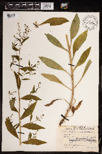 Hackelia virginiana (L.) I.M. Johnston 967876[1368459]Drew, L.A. s.n.1969-06-20 United States, Minnesota, Lyon, 14 miles S Marshall, 44.254967 -95.789727 |
MIN:Plants | Hackelia virginiana (L.) I.M. Johnston []Timothy J. S. Whitfeld 32842022-07-01 United States, Minnesota, Washington, Crystal Spring Scientific and Natural Area, 0.4 miles northeast of the intersection of Scandia Trail North and Hwy 95, 45.261166 -92.764251, 239m |
MIN:Plants | 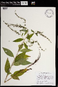 Hackelia virginiana (L.) I.M. Johnston 970873[1394341]Smith, Welby R WRS358122017-09-04 United States, Minnesota, Ramsey, On the east side of Sucker Lake in Shoreview., 45.07385 -93.094 |
MIN:Plants | 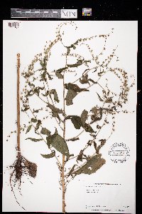 Hackelia virginiana (L.) I.M. Johnston 973613[1397167]Bezanson, Char A. 2361991-07-25 United States, Minnesota, Rice, 44.318989 -93.433188 |
MIN:Plants | 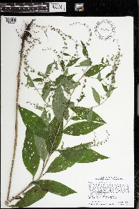 Hackelia virginiana (L.) I.M. Johnston 974560[1396924]Smith, Welby R WRS364202019-08-07 United States, Minnesota, McLeod, Liable Woods (Nature Conservancy preserve), about 4.8 km (3 miles) east of Biscay at a heading of 80 degrees., 44.834664 -94.215364 |
MIN:Plants |  Hackelia virginiana (L.) I.M. Johnston 976062[1373615]Smith, Welby R WRS367842020-08-02 United States, Minnesota, Dakota, Pine Bend State Scientific and Natural Area, in Inver Grove Heights., 44.790986 -93.030597 |
MIN:Plants | Phacelia hydrophylloides Torrey ex A. Gray 235529[]Congdon, J. s.n.1890-08-10 United States, California, Mariposa, Crescent Lake, Mariposa County;Yosemite National Park;;;, 37.56466 -119.53348 |
MIN:Plants | Phacelia hydrophylloides Torrey ex A. Gray 235532[]Congdon, J. s.n.1885-06-30 United States, California, Mariposa, Glacier Point Turnpike;Yosemite National Park;;;, 37.73083 -119.57278 |
MIN:Plants | Nama lobbii A. Gray 499355[]Went, F. s.n. United States, California, Nevada, Donner Pass, Nevada Co. |
MIN:Plants | Romanzoffia sitchensis Bongard 600235[]Cooper, William 1801929-07-14 United States, Alaska, Glacier Bay, Station 7;Glacier Bay National Park;;;, 58.607862 -135.84184 |
MIN:Plants |  Mertensia paniculata var. paniculata (Aiton) G. Don 510963[1348689]Gerdes, Lynden; et al. 24781998-05-23 United States, Minnesota, Cook, Boundary Waters Canoe Area Wilderness / Superior National Forest. T65N R03E S27NENW. Cook County ... Superior National Forest, BWCAW ... creek/drainage south of the Moose Lake/North Fowl Lake portage.. 065N 03E 27, 48.09144 -90.04648 |
MIN:Plants | Mertensia paniculata var. paniculata (Aiton) G. Don 910647[]Perry, Ethan 080222008-07-24 United States, Minnesota, Itasca, Itasca County...830 meters S of Battle Lake...T62N R24W SE1/4 NE1/4 Sec36;George Washington State Forest;062N;24W;36, 47.8158333 -93.3422222 |
MIN:Plants | Mertensia paniculata var. paniculata (Aiton) G. Don 179630[]Wood, F. s.n.1899-06-00 United States, Minnesota, Saint Louis, Fond du Lac;;N;;, 46.664494 -92.27136 |
MIN:Plants | Mertensia paniculata var. paniculata (Aiton) G. Don 179638[]Sandberg, John s.n.1885-06-00 United States, Minnesota, Saint Louis, Tower;;N;;, 47.810087 -92.283188 |
MIN:Plants | Mertensia paniculata var. paniculata (Aiton) G. Don 179639[]Sandberg, John s.n.1890-06-00 United States, Minnesota, Lake, Two Harbors;;N;;, 47.028562 -91.671762 |
MIN:Plants | Mertensia paniculata var. paniculata (Aiton) G. Don 179640[]Cheney, L. s.n.1891-06-16 United States, Minnesota, Saint Louis, Fond du Lac;;N;;, 46.664494 -92.27136 |
MIN:Plants |  Mertensia paniculata var. paniculata (Aiton) G. Don 490434[1348684]Lee, Michael MDL27422000-06-22 United States, Minnesota, Lake, Superior National Forest. Lake County...in the Superior National Forest 2-1/2 miles north of Cramer...northeast of Paccini Lake...T59N R6W SW1/4 of SE1/4 of SE1/4 Sec. 27. 059N 06W 27, 47.560269 -91.068728 |
MIN:Plants | Mertensia paniculata var. paniculata (Aiton) G. Don 179641[]Sandberg, John s.n.1891-00-00 United States, Minnesota, N shore of Lake S.;North Shore;;;, 47.483605 -91.02175 |
MIN:Plants | Mertensia paniculata var. paniculata (Aiton) G. Don 179642[]Sheldon, Edmund S41781893-06-00 United States, Minnesota, Lake, Two Harbors;North Shore;052N;11W;01, 47.01954 -91.67918 |
MIN:Plants | Mertensia paniculata var. paniculata (Aiton) G. Don 179643[]Herrick, C. s.n.1884-06-26 United States, Minnesota, Carlton, St. Louis River [prob near WI state line];Jay Cooke State Park;048N;15W;, 46.649665 -92.330748 |
MIN:Plants | Mertensia paniculata var. paniculata (Aiton) G. Don 179644[]Sandberg, John 30351885-06-00 United States, Minnesota, Lake, Agate Bay;North Shore;052N;11W;01, 47.01954 -91.67918 |
MIN:Plants | Mertensia paniculata var. paniculata (Aiton) G. Don 179645[]Sandberg, John s.n.1891-07-00 United States, Minnesota, Lake, Two Harbors;North Shore;052N;11W;01, 47.01954 -91.67918 |
MIN:Plants | Mertensia paniculata var. paniculata (Aiton) G. Don 179646[]Roberts, Thomas s.n.1878-06-19 United States, Minnesota, Saint Louis, Duluth;;N;;, 46.780452 -92.109326 |
MIN:Plants | Mertensia paniculata var. paniculata (Aiton) G. Don 179647[]Arthur, J.; et al. B2681886-07-23 United States, Minnesota, Saint Louis, Vermilion Lake;;;;, 47.881451 -92.326999 |
MIN:Plants | Mertensia paniculata var. paniculata (Aiton) G. Don 229446[]Butters, F.; et al. 44771924-06-29 United States, Minnesota, Lake, Near Two Harbors, North Shore Lake Superior;;;;, 47.029732 -91.674509 |
MIN:Plants | Mertensia paniculata var. paniculata (Aiton) G. Don 246755[]Sheldon, Edmund s.n.1893-06-00 United States, Minnesota, Lake, Two Harbors;;N;;, 47.028562 -91.671762 |
MIN:Plants | Mertensia paniculata var. paniculata (Aiton) G. Don 276782[]Huff, N. s.n.1925-07-10 United States, Minnesota, Cook, Grand Marais;North Shore;061N;01E;, 47.752886 -90.336714 |
MIN:Plants | Mertensia paniculata var. paniculata (Aiton) G. Don 278277[]Roberts, Thomas s.n.1877-07-00 United States, Minnesota, Saint Louis, Duluth;;N;;, 46.780452 -92.109326 |
MIN:Plants | Mertensia paniculata var. paniculata (Aiton) G. Don 346109[]Lakela, Olga 19481937-06-06 United States, Minnesota, Saint Louis, Lester Park, Duluth;North Shore;050N;13W;05, 46.8440162 -92.0161028 |
MIN:Plants | Mertensia paniculata var. paniculata (Aiton) G. Don 352331[]Benner, F.; Benner, J. 4791929-07-27 United States, Minnesota, Cook, 1/2 mi. E of E Grand Portage;Grand Portage Indian Reservation / North Shore;063N;06E;, 47.958468 -89.703576 |
MIN:Plants | Mertensia paniculata var. paniculata (Aiton) G. Don 353449[]Lakela, Olga 23891938-05-28 United States, Minnesota, Lake, At foot of Silver Creek Cliff, lakeside, on Hwy. 61;North Shore;053N;10W;21, 47.068308 -91.592203 |
MIN:Plants | Mertensia paniculata var. paniculata (Aiton) G. Don 353672[]Lakela, Olga 23961938-05-28 United States, Minnesota, Lake, At the base of Palisade Head;North Shore / Palisade Head;056N;07W;22, 47.323378 -91.211297 |
MIN:Plants | Mertensia paniculata var. paniculata (Aiton) G. Don 353736[]Lakela, Olga 24711938-06-21 United States, Minnesota, Saint Louis, Along old r.r. track, next to Anna Kilpela's;;057N;15W;, 47.4153244 -92.2397132 |
MIN:Plants | Mertensia paniculata var. paniculata (Aiton) G. Don 356391[]Lakela, Olga 29481939-06-09 United States, Minnesota, Saint Louis, Fond du Lac;;N;;, 46.664494 -92.27136 |
MIN:Plants | Mertensia paniculata var. paniculata (Aiton) G. Don 356472[]Lakela, Olga 28891939-05-28 United States, Minnesota, Saint Louis, On Grand Rapids Road, ca. 1/2 mi. from its jct. of Miller Trunk Hwy. 11 mi. N of Duluth;;N;;, 46.96314 -92.445782 |
MIN:Plants | Mertensia paniculata var. paniculata (Aiton) G. Don 360607[]Lakela, Olga 34991940-06-10 United States, Minnesota, Lake, Ca. 2 mi. N of Two Harbors on Brimson Road;;N;;, 47.068503 -91.667299 |
MIN:Plants | Mertensia paniculata var. paniculata (Aiton) G. Don 362023[]Moyle, J. 35411940-06-23 United States, Minnesota, Lake, Near Two Harbors;;N;;, 47.022711 -91.670732 |
MIN:Plants | Mertensia paniculata var. paniculata (Aiton) G. Don 362784[]Benner, F.; Benner, J. 6631929-08-23 United States, Minnesota, Cook, about 5 mi N of Hovland;Grand Portage State Forest / North Shore;063N;04E;, 47.93199 -89.97803 |
MIN:Plants | Mertensia paniculata var. paniculata (Aiton) G. Don 380196[]Lakela, Olga 53321943-07-05 United States, Minnesota, Saint Louis, Woods of the North Shore of Lake Superior, near the pumping station, Duluth;;N;;, 46.719655 -92.197581 |
MIN:Plants | Mertensia paniculata var. paniculata (Aiton) G. Don 391753[]Lakela, Olga 59471945-05-26 United States, Minnesota, Lake, Shorewoods of Lake Superior at the Jacobson's Landing, East Beaver Bay;;N;;, 47.2677 -91.282943 |
MIN:Plants | Mertensia paniculata var. paniculata (Aiton) G. Don 391956[]Lakela, Olga 63321946-06-16 United States, Minnesota, Cook, North Shore, Hwy. 61, near Tofte. Cook Co.;North Shore / Superior National Forest;059N;04W;, 47.57653 -90.8317 |
MIN:Plants | Mertensia paniculata var. paniculata (Aiton) G. Don 393305[]Lakela, Olga 69081947-07-05 United States, Minnesota, Saint Louis, Terrace of Whiteface River, 1 mi. W of Cotton;;N;;, 47.174221 -92.498451 |
MIN:Plants | Mertensia paniculata var. paniculata (Aiton) G. Don 393312[]Lakela, Olga 68671947-06-28 United States, Minnesota, Saint Louis, Near Fish Lake, ca. 15 mi. N of Duluth;;N;;, 46.947013 -92.268627 |
MIN:Plants | Mertensia paniculata var. paniculata (Aiton) G. Don 393824[]Butters, F.; Abbe, E.; Abbe, L. 2391937-07-02 United States, Minnesota, Cook, At W end of Mountain Lake. T65N, R01E;Boundary Waters Canoe Area Wilderness / Superior National Forest;065N;01E;, 48.10113 -90.29852 |
MIN:Plants | Mertensia paniculata var. paniculata (Aiton) G. Don 393825[]Dahl, A. 81945-06-16 United States, Minnesota, Cook, Along trails, etc. Base South Lake Trail, near Poplar Lake. T64N, R02W, Sec. 1;Superior National Forest;064N;02W;1, 48.055732 -90.522779 |
MIN:Plants | Mertensia paniculata var. paniculata (Aiton) G. Don 393826[]Butters, F.; et al. 191938-07-05 United States, Minnesota, Cook, 1/2 way across portage along international boundary between Mountain and Watab Lakes.;Boundary Waters Canoe Area Wilderness / Superior National Forest;065N;01E;, 48.10316 -90.30109 |
MIN:Plants | Mertensia paniculata var. paniculata (Aiton) G. Don 393827[]Butters, F.; et al. 821938-07-09 United States, Minnesota, Cook, 1/2 mi. from the E end of Mountain Lake.;Boundary Waters Canoe Area Wilderness / Superior National Forest;065N;02E;, 48.10606 -90.17235 |
MIN:Plants | Mertensia paniculata var. paniculata (Aiton) G. Don 393828[]Burns, G.; Hendrickson, M. 2911938-07-28 United States, Minnesota, Cook, On portage around the upper rapids of Royal River. T64N, R3E.;Boundary Waters Canoe Area Wilderness / Superior National Forest;064N;03E;, 48.05525 -90.02416 |
MIN:Plants | Mertensia paniculata var. paniculata (Aiton) G. Don 393829[]Burns, G.; Hendrickson, M. 3621938-07-29 United States, Minnesota, Cook, 3/8 mi. E of the source of the Royal River. T64N, R3E;Boundary Waters Canoe Area Wilderness / Superior National Forest;064N;03E;, 48.05212 -90.01519 |
MIN:Plants | Mertensia paniculata var. paniculata (Aiton) G. Don 393830[]Nielsen, E.; Breckenridge, Walter 32191935-06-08 United States, Minnesota, Cook, Cook Co.; Naniboujou Club, near Grand Portage;Grand Portage Indian Reservation / North Shore;062N;03E;, 47.849836 -90.064949 |
MIN:Plants | Mertensia paniculata var. paniculata (Aiton) G. Don 393948[]Butters, F.; Abbe, E.; Burns, G. 6281940-06-29 United States, Minnesota, Cook, W shore of South Fowl Lake;Superior National Forest;064N;03E;, 48.053566 -90.003137 |
MIN:Plants | Mertensia paniculata var. paniculata (Aiton) G. Don 393950[]Butters, F.; Abbe, E. 2101936-06-30 United States, Minnesota, Cook, Near Grand Portage. T63N, R06E;Grand Portage Indian Reservation / North Shore;063N;06E;, 47.958468 -89.703576 |
MIN:Plants | Mertensia paniculata var. paniculata (Aiton) G. Don 404960[]Moyle, J.; et al. 36841941-06-29 United States, Minnesota, Fillmore, Near Wykoff, Fillmore Co.;Dorer Memorial Hardwood State Forest;103N;12W;, 43.7174101 -92.2692781 |
MIN:Plants | Mertensia paniculata var. paniculata (Aiton) G. Don 404962[]Moyle, J.; et al. 36841941-06-29 United States, Minnesota, Fillmore, Near Wykoff, Fillmore Co.;Dorer Memorial Hardwood State Forest;103N;12W;, 43.7174101 -92.2692781 |
MIN:Plants | Mertensia paniculata var. paniculata (Aiton) G. Don 405401[]Lakela, Olga 80931949-05-22 United States, Minnesota, Saint Louis, North Shore Woods, ca. 18 mi. from Duluth;;N;;, 47.111089 -92.018822 |
MIN:Plants | Mertensia paniculata var. paniculata (Aiton) G. Don 413126[]Moore, John; Moore, Marjorie 111061939-07-24 United States, Minnesota, Lake of the Woods, Angle Inlet;Northwest Angle;168N;34W;, 49.345274 -95.062738 |
MIN:Plants | Mertensia paniculata var. paniculata (Aiton) G. Don 419243[]Briggs, John De Q.; Moore, Marjorie 511945-08-03 United States, Minnesota, Cook, Sawbill Trail;Superior National Forest;062N;04W;, 47.845796 -90.829882 |
MIN:Plants | Mertensia paniculata var. paniculata (Aiton) G. Don 419353[]Lakela, Olga 103371950-06-11 United States, Minnesota, Saint Louis, Near Gappa's Landing, Lake Kabetogama;Voyageurs National Park;N;;, 48.440542 -93.022396 |
MIN:Plants | Mertensia paniculata var. paniculata (Aiton) G. Don 419456[]Lakela, Olga 103661950-06-13 United States, Minnesota, Saint Louis, Side of Hwy. 53, Ash Lake area;Kabetogama State Forest;N;;, 48.213452 -92.937287 |
Google Map
Google Maps is a web mapping service provided by Google that features a map that users can pan (by dragging the mouse) and zoom (by using the mouse wheel). Collection points are displayed as colored markers that when clicked on, displays the full information for that collection. When multiple species are queried (separated by semi-colons), different colored markers denote each individual species.