University of Minnesota
http://www.umn.edu/
612-625-5000
http://www.umn.edu/
612-625-5000
Minnesota Biodiversity Atlas
Bell Museum
Dataset: MIN-Plants
Taxa: Caprifoliaceae
Search Criteria: excluding cultivated/captive occurrences
Bell Museum plants | |
 MIN:Plants | 904490[]Smith, Welby 273681998-07-10 United States, Minnesota, Otter Tail, Bluff Creek Wildlife Management Area. Otter Tail County ... Bluff Creek State Wildlife Management Area, about 11 miles west of Sebeka ... T136N R37W NE1/4 of NW1/4 of Sec 2. 136N 37W 2, 46.6286111 -95.3144444 |
MIN:Plants | 429285[]Smith, Welby 256361995-06-01 United States, Minnesota, Mower, Mower County ... Lake Louise State Park, about 1.5 miles northwest of LeRoy ... T 101N R 14W NW1/4 of NW1/4 of Sec 28;Lake Louise State Park;101N;14W;28, 43.522099 -92.518958 |
MIN:Plants | 912875[]Smith, Welby 241961994-05-31 United States, Minnesota, Koochiching, Franz Jevne State Park. Koochiching County...Franz Jevne State Park. In the Rainy River Valley, about 2 miles northeast of Birchdale...upper floodplain of the Rainy River...T 160N R 27W SW1/4 of SW1/4 of Sec 26. 160N 27W 26, 48.6427778 -94.0783333 |
MIN:Plants | 194920[]Sheldon, Edmund s.n.1895-05-00 United States, Minnesota, Ramsey, Lake Vadnais. Ramsey Co.;;030N;22W;, 45.079894 -93.045502 |
MIN:Plants | 194922[]Sheldon, Edmund s.n.1895-05-00 United States, Minnesota, Ramsey, Lake Vadnais. Ramsey Co.;;030N;22W;, 45.079894 -93.045502 |
MIN:Plants | 194951[]Tilden, Josephine Tn.231893-06-00 United States, Minnesota, Cass, Gull Lake. Cass Co.;;;;, 46.446379 -94.35099 |
MIN:Plants | 195169[]Goldsmith, G. G.1401912-00-00 United States, Minnesota, Rice, Northfield;;;;, 44.45833 -93.16139 |
MIN:Plants | 278030[]Roberts, Thomas s.n.1880-05-18 United States, Minnesota, Hennepin, Minneapolis;;;;, 44.98 -93.26361 |
MIN:Plants | 288115[]Jahnke, E. s.n.1914-05-20 United States, Minnesota, Ramsey, Como Park;;029N;23W;, 44.992077 -93.166387 |
MIN:Plants | 332552[]Grant, Martin 66481935-08-17 United States, Minnesota, Clearwater, Itasca Park ... County: Clearwater. Loc.: Bohall Trail. Sec. NE-SW-10 T.143 R.36.;Itasca State Park;143N;36W;10, 47.217267 -95.223034 |
MIN:Plants | 459124[]Smith, Welby 130711987-06-19 United States, Minnesota, Washington, Washington County ... About 7 miles west of Marine on St. Croix ... NW1/4 NE1/4 sec. 2, T 31N R 21W;;031N;21W;02, 45.207222 -92.9238892 |
MIN:Plants | 463693[]Myhre, K. 43751993-08-07 United States, Minnesota, Pine, General C C Andrews State Forest. Pine Co.; located in the campground on the Willow River near the town of Willow River; T 44N R 20W SE1/4 of NE1/4 of Sec Pine Co.; located in the campground on the Willow River near the town of Willow River; T 44N R 20W SE1/4 of NE1/4 of Sec 2. 044N 20W 2, 46.323799 -92.837611 |
MIN:Plants | 473821[]Smith, Welby 206071992-06-25 United States, Minnesota, Redwood, Redwood Co.; In Alexander Ramsey city park in Redwood Falls; in the Redwood River Valley; T113N R36W NW1/4 of SE1/4 of Sec 36. 113N 36W 36, 44.5480556 -95.1244444 |
MIN:Plants | 506160[]Lee, Michael; et al. MDL8651995-05-09 United States, Minnesota, Wabasha, Wabasha Co.; terrace along the Zumbro River 1 1/2 mi NE of Hammond; T109N R13W NESWNW 23;Dorer Memorial Hardwood State Forest;109N;13W;23, 44.230316 -92.340677 |
MIN:Plants | 506688[]Parker, L. 861992-06-24 United States, Minnesota, Lake, Collected on the shore of Murphy Creek, app. 10 mi E of Fairbanks [in St. L. Co.] ... County: Lake;Superior National Forest;057N;11W;27, 47.393058 -91.712647 |
MIN:Plants | 520146[]Smith, Welby 132551987-06-29 United States, Minnesota, Washington, Washington County ... Corries Swamp; large wetland about 8 miles west of Marine on St. Croix ... NW1/4 SE1/4 etc.;;032N;21W;26, 45.2161102 -92.9244461 |
MIN:Plants | 566733[]Lang, H. 531878-05-16 United States, Minnesota, Ramsey, St. Paul;;;;, 44.949027 -93.097731 |
MIN:Plants | 566750[]Lang, H.; et al. 551878-05-09 United States, Minnesota, Ramsey, St. Paul;;;;, 44.949027 -93.097731 |
MIN:Plants | 594416[]Thorne, Robert 310201962-07-11 United States, Minnesota, Polk, Norman County ... ca. 1 mi. SW of Fertile. Sec. 32, T 147 N, R 44 W, Garfield Twp. [this is actually Polk Co.];Agassiz Dunes Scientific Natural Area;147N;44W;32, 47.50708 -96.291418 |
MIN:Plants | 750297[]Almendinger, J. 27001980-09-23 United States, Minnesota, Hubbard, Hubbard County ... 1/2 mi. SE of Dorset, SW of SW of Sec. 11, T140N, R34W.;;140N;34W;11, 46.957384 -94.942191 |
MIN:Plants | 750315[]Almendinger, J. 25131980-09-22 United States, Minnesota, Hubbard, Hubbard County ... 1 mi. east of Moran Lake, SE of SW S. 13, T 139 N, R 35 W.;;139N;35W;13, 46.856191 -95.047978 |
MIN:Plants | 750347[]Almendinger, J. 20021980-07-27 United States, Minnesota, Hubbard, Hubbard County ... west shore of Shrinker Lake, SW of NW S. 31, T 140 N, R 33 W;;140N;33W;31, 46.89921 -94.902238 |
MIN:Plants | 750403[]Almendinger, J. 15021980-07-23 United States, Minnesota, Hubbard, Hubbard County ... east shore of Moran Lake, NE of SE of S. 14, T 139 N, R 35 W.;;139N;35W;14, 46.856079 -95.068924 |
MIN:Plants | 750482[]Almendinger, J. 36061981-08-19 United States, Minnesota, Beltrami, Beltrami County ... 3-1/2 mi. north of Wilton, SW of NW of S. 10, T 147 N, R 34 W.;;147N;34W;10, 47.563653 -94.981442 |
MIN:Plants | 802836[]Smith, Welby 114721986-05-17 United States, Minnesota, Anoka, Lamprey Pass Wildlife Management Area. Anoka County ... Lamprey Pass State Wildlife Management Area, about 2 mi. southwest of Forest Lake ... SW1/4 NE1/4 Sec. 13, T32N, R22W. 032N 22W 13, 45.26283 -93.027476 |
MIN:Plants | 830104[]Wennerstrand, R. 451992-08-02 United States, Minnesota, Roseau, Roseau County ... SW1/4 NE1/4 Sec 34 T163N R37W;Lost River State Forest;163N;37W;34, 48.893832 -95.40735 |
MIN:Plants | 831987[]Sutton, S. s.n.1981-06-19 United States, Minnesota, Saint Louis, County: St. Louis ... R-12W T-64N Sec. 36;Superior National Forest;064N;12W;36, 47.984107 -91.81009, 427m |
MIN:Plants | 840676[]Smith, Welby 126791987-05-09 United States, Minnesota, Scott, Murphy-Hanrahan County Park Reserve. Scott County ... Murphy-Hanrahan Regional Park; on the south side of Hanrahan Lake, about 2 mi west of ... Burnsville ... SW1/4 NW1/4 sec. 34, T 115N R 21W. 115N 21W 34, 44.7277794 -93.3363876 |
MIN:Plants | 194909[]Aiton, G. s.n.1890-05-00 United States, Minnesota, Hennepin, Vic. [Minneapolis];;;;, 44.979965 -93.263836 |
MIN:Plants | 194913[]Sandberg, John s.n.1890-06-00 United States, Minnesota, Hennepin, [no further data];;;;, 45 -93.47 |
MIN:Plants | 194918[]Burglehaus, F. s.n.1891-05-21 United States, Minnesota, Hennepin, Hennepin Co..;;;;, 45 -93.47 |
MIN:Plants | 194934[]Sheldon, Edmund S23981892-06-00 United States, Minnesota, Aitkin, Farm Island Lake. Aitkin Co.;;046N;27W;, 46.460889 -93.748606 |
MIN:Plants | 194941[]Sandberg, John s.n.1881-05-00 United States, Minnesota, Goodhue, Cannon Falls;;112N;17W;18, 44.507071 -92.90512 |
MIN:Plants | 194942[]Holzinger, John 471886-05-14 United States, Minnesota, Winona, Winona bluffs;;;;, 44.0333 -91.6333 |
MIN:Plants | 194946[]Taylor, B. T371891-06-00 United States, Minnesota, Le Sueur, Elysian. Le Sueur Co.;;109N;24W;, 44.239498 -93.707142 |
MIN:Plants | 194948[]Frost, W. F1131892-06-00 United States, Minnesota, Meeker, Litchfield, Meeker Co.;;120N;31W;, 45.196121 -94.568246 |
MIN:Plants | 194955[]Ballard, C. B6841891-07-00 United States, Minnesota, Carver, Waconia;;116N;25W;, 44.8476 -93.827753 |
MIN:Plants | 194956[]Wheeler, William 1901899-06-13 United States, Minnesota, Houston, Winnebago Valley;Dorer Memorial Hardwood State Forest;;;, 43.66667 -91.50056 |
MIN:Plants | 194959[]Taylor, B. T9081891-07-00 United States, Minnesota, Pope, Glenwood;;125N;37W;, 45.62853 -95.32519 |
MIN:Plants | 194960[]Sheldon, Edmund S.37641892-08-00 United States, Minnesota, Otter Tail, Lake Lida, Otter Tail Co.;;136N;42W;, 46.586287 -95.968922 |
MIN:Plants | 194961[]Sheldon, Edmund S8011891-07-00 United States, Minnesota, Brown, Sigel Twp. Brown Co.;;109N;31W;, 44.23941 -94.55827 |
MIN:Plants | 194963[]Ballard, C. B2291891-06-00 United States, Minnesota, Scott, Jordan, Scott Co.;;114N;23W;, 44.674435 -93.582701 |
MIN:Plants | 194964[]Ballard, C. B3861891-07-00 United States, Minnesota, Scott, Jordan, Scott Co.;;114N;23W;, 44.674435 -93.582701 |
MIN:Plants | 194966[]Bergman, H. 31921914-09-04 United States, Minnesota, Hubbard, Benedict;;143N;32W;35, 47.15729 -94.6957 |
MIN:Plants | 194968[]Sheldon, Edmund S2351891-06-00 United States, Minnesota, Blue Earth, Lake Washington. B.E. Co.;;109N;25W;, 44.239469 -93.828345 |
MIN:Plants | 225036[]Butters, F.; et al. 49451926-05-24 United States, Minnesota, Winona, North end of Gwinns Bluff. Winona County;Great River Bluffs State Park;106N;05W;, 43.963328 -91.43962 |
MIN:Plants | 271203[]Tierney, Dillon s.n.1913-05-24 United States, Minnesota, Dakota, Farmington;;114N;19W;, 44.673933 -93.095705 |
MIN:Plants | 282493[]Lakela, Olga 5561933-05-10 United States, Minnesota, Anoka, along road to New Brighton, from Anoka Sand dunes;;;;, 45.197743 -93.387176 |
MIN:Plants | 371073[]Moore, John; et al. 13886A1941-05-10 United States, Minnesota, Mower, north bank of Deer Creek; along Highway 63, Frankford Township, Mower County;;103N;14W;, 43.717809 -92.50951 |
MIN:Plants | 680876[]Wheeler, Gerald; Glaser, Paul 10751977-05-07 United States, Minnesota, Olmsted, Dorer Memorial Hardwood State Forest. Olmsted County ... Approx. 3 mi south of Simpson on Hwy. 1, and about 1/2 mi. SSE of the bridge over the Root River following the S bank of the river ... T 105 N, R 13 W, Sec. 20.. 105N 13W 20, 43.884292 -92.408371 |
MIN:Plants | 696741[]Smith, Welby 8321978-06-02 United States, Minnesota, Wright, Wright County ... T. 121N, R. 27W, S.W.1/4 sec. 9. SE corner of Clearwater Lake.;;121N;27W;09, 45.30094 -94.091601 |
MIN:Plants | 715372[]Farrell, P. 471979-06-28 United States, Minnesota, Beltrami, Beltrami County ... Lake Bemidji Bog SNA: 1 mi. northwest of Lake Bemidji, N1/2 NW1/4 Sec. 24, T 147N, R 33W.;Lake Bemidji State Park;147N;33W;24, 47.533209 -94.810311 |
MIN:Plants | 763485[]Lugger, O. 29951895-05-16 United States, Minnesota, Washington, Newport [Washington Co. pencilled later];;029N;21W;, 44.992361 -92.923695 |
MIN:Plants | 770584[]Smith, Welby 84091983-07-26 United States, Minnesota, Mower, Lake Louise State Park. Mower County ... Lake Louise State Park, about 1 mi. north-northwest of LeRoy ... Upper Iowa River ... NW1/4 NE1/4 Sec. 28, T 101N, R 14W.. 101N 14W 28, 43.522099 -92.518958 |
MIN:Plants | 194911[]Ainslie, G. s.n.1904-05-28 United States, Minnesota, Olmsted, Rochester;;106N;14W;, 43.97834 -92.49834 |
MIN:Plants | 194912[]Taylor, B. T391891-06-00 United States, Minnesota, Le Sueur, Elysian - LeSueur Co.;;109N;24W;, 44.239498 -93.707142 |
MIN:Plants | 194916[]Rosendahl, C.; Butters, F. 25571912-05-25 United States, Minnesota, Ramsey, near White Bear;;030N;22W;, 45.079894 -93.045502 |
MIN:Plants | 194940[]Ainslie, G. 34581902-05-24 United States, Minnesota, Olmsted, Rochester;;106N;14W;, 43.97834 -92.49834 |
MIN:Plants | 194943[]Sheldon, Edmund s.n.1891-05-00 United States, Minnesota, Ramsey, Ramsey Co.;;;;, 45.008836 -93.08764 |
MIN:Plants | 194958[]Sheldon, Edmund S.33531892-08-00 United States, Minnesota, Otter Tail, Battle Lake;;133N;40W;, 46.32559 -95.717658 |
MIN:Plants | 225037[]Holzinger, John s.n.1905-05-00 United States, Minnesota, Winona, Bluff back of Buck bungalow, etc. ... in Winona Co.;;;;, 44.05 -91.6333 |
MIN:Plants | 282311[]Rosendahl, C. 61801930-05-25 United States, Minnesota, on Anoka-Isanti Co. line, about 1-1/2 mi. E of Hwy. 5 [hwy 65?];;034N;23W;00, 45.428063 -93.203997 |
MIN:Plants | 282312[]Rosendahl, C. 61751930-05-20 United States, Minnesota, Ramsey, In Rice St. tamarack swamp, Ramsey Co.;;;;, 45.01623 -93.10604 |
MIN:Plants | 288519[]Erickson, Lawrence s.n.1915-05-00 United States, Minnesota, Hennepin, Near r.r. tracks at Ft. Snelling;Fort Snelling Military Reservation;028N;23W;, 44.905162 -93.166462 |
MIN:Plants | 301908[]Himebaugh, W. s.n.1928-05-00 United States, Minnesota, Chisago, Taylors Falls;Saint Croix National Riverway;034N;19;, 45.426028 -92.716274 |
MIN:Plants | 351226[]Seashore, Mauritz s.n.1932-05-20 United States, Minnesota, Scott, Savage;;115N;21W;, 44.753605 -93.344349 |
MIN:Plants | 366463[]Rosendahl, C. 71281939-07-11 United States, Minnesota, Houston, Riceford Creek Valley, Houston County;Dorer Memorial Hardwood State Forest;;;, 43.605113 -91.707515 |
MIN:Plants | 374015[]Linnaean Club, U of M, 761939-05-21 United States, Minnesota, Rice, Nerstrand Woods. Rice Co. ... Along road near falls.;Nerstrand Woods State Park;110n;19W;, 44.327064 -93.100886 |
MIN:Plants | 375353[]Lakela, Olga 49421942-06-07 United States, Minnesota, Carlton, near Holyoke. Carlton Co.;;046N;16W;, 46.460785 -92.362893 |
MIN:Plants | 393302[]Lakela, Olga 68701947-06-28 United States, Minnesota, Saint Louis, border on #48, about 10 mi. N.W. of Duluth;;;;, 46.783273 -92.106579 |
MIN:Plants | 720292[]Ottoson, S. 421979-06-20 United States, Minnesota, 2 miles southwest of Fertile.;Agassiz Dunes Scientific Natural Area;;;, 47.51564 -96.31032 |
MIN:Plants | 729561[]Cutler, S. 1391980-07-16 United States, Minnesota, Pine, Pine County ... St. Croix Natural Area: 21 mi. east of Hinckley. NW1/4 SE1/4 Sec. 33, T41, R17W.;Saint Croix State Park;041N;17W;33, 45.990519 -92.498401 |
MIN:Plants | 772941[]Boe, J. 4141979-06-27 United States, Minnesota, Lake of the Woods, Lady Slipper Rest, roadside rest area in Williams. NE 1/4 of section;<No data>;161N;34W;13, 48.764296 -94.96955 |
MIN:Plants | 773638[]Boe, J. 3821979-06-24 United States, Minnesota, Lake of the Woods, Lake of the Woods County ... Near Norris Camp ... Sec. 8, R35W, T159N.;Beltrami Island State Forest;159N;35W;08, 48.605309 -95.181076 |
MIN:Plants | 505313[]Smith, Welby 222931993-06-03 United States, Minnesota, Sibley, Vale Wildlife Management Area. Sibley County ... Vale State Wildlife Management Area; in the valley of High Island Creek, about 2.5 miles southwest of its confluence with the Minnesota River ... T 113N R 26W NE1/4 of SW1/4 of Sec 27. 113N 26W 27, 44.5625 -93.9427795 |
MIN:Plants | 436895[]Smith, Welby 270461998-05-12 United States, Minnesota, Koochiching, Koochiching County...Where County Road 5 crosses the Big Fork River at Craigville...T 63N R 26W SE1/4 of NW1/4 of Sec 36;Koochiching State Forest;063N;26W;36, 47.9069443 -93.6108322 |
MIN:Plants | 905850[]Smith, Welby 274961998-08-11 United States, Minnesota, Itasca, Itasca County...On the west side of Little Ball Club Lake...T146N R26W NW1/4 of SE1/4 of Sec 32;Chippewa National Forest / Leech Lake Indian Reservation;146N;26W;32, 47.4188889 -93.9986111 |
MIN:Plants | 428914[]Smith, Welby 265721997-06-04 United States, Minnesota, Renville, Beaver Falls County Park. Renville County ... Beaver Falls County Park, about 4 miles northeast of Redwood Falls ... T 113N R 35W SW1/4 of NW1/4 of Sec 22. 113N 35W 22, 44.582222 -95.0533371 |
MIN:Plants | 905658[]Smith, Welby 272821998-06-25 United States, Minnesota, Anoka, Anoka County...Rum River North County Park, about 7 miles NW of East Bethel...T134N [sic] R24W NW1/4 of NE1/4 of Sec 32;Rum River County Park;034N;24W;32, 45.3902778 -93.355 |
MIN:Plants | 920833[]Smith, Welby 222931993-06-03 United States, Minnesota, Sibley, Vale Wildlife Management Area. Sibley County ... Vale State Wildlife Management Area; in the valley of High Island Creek, about 2.5 miles southwest of its confluence with the Minnesota River ... T113N R26W NE1/4 of SW1/4 of Sec 27. 113N 26W 27, 44.5625 -93.9427778 |
MIN:Plants | 912971[]Smith, Welby 243481994-06-14 United States, Minnesota, Lyon, Lyon County...Camden State Park, about 3 miles north-northeast of Russell...T 110N R 42W NE1/4 of SW1/4 of Sec 5;Camden State Park;110N;42W;05, 44.36 -95.9294444 |
MIN:Plants | 921036[]Smith, Welby 249591994-07-27 United States, Minnesota, Crow Wing, Crow Wing State Park, about 4 miles southwest of Barrows...T 44N R 32W NW1/4 of SE1/4 of Sec 23;Crow Wing State Park;044N;32W;23, 46.2772222 -94.3391667 |
MIN:Plants | 931182[]Gerdes, Lynden B.; Walewski, Joe W. 62632011-06-16 United States, Minnesota, Lake, Superior National Forest. West end Topaz Lake. Approximately 0.30 miles NNW of the portage between Amoeber Lake and Topaz Lake. SWNWSENW. 065N 06W 8, 48.13 -91.1344444 |
MIN:Plants | 930731[]Gerdes, Lynden B. 59742010-05-26 United States, Minnesota, Cook, Magnetic Rock Hiking Trail area. Approximately 0.28 miles east of the Gunflint Trail. NWSWSESE of section;Superior National Forest;065N;04W;22, 48.0930556 -90.82 |
MIN:Plants | 931678[]Smith, Welby R. 202481992-05-20 United States, Minnesota, Marshall, about 11 miles east of Argyle NW of SE of section;Old Mill State Park;156N;46W;04, 48.3602778 -96.5702778 |
MIN:Plants | 931660[]Smith, Welby R. 201981992-05-20 United States, Minnesota, Pennington, On the east bank of the Red Lake River, just across the river (southeast) from St. Hilare SE of SE of section;;152N;43W;06, 48.0072222 -96.2011111 |
MIN:Plants | 934267[]Partch, M. s.n.1957-05-03 United States, Minnesota, Kandiyohi, Mud Lake Huron Colony, Island 2, north of New London.;<No data>;121N;34W;, 45.282291 -94.947684 |
MIN:Plants | 937011[]Smith, Welby R. 302942007-07-12 United States, Minnesota, Beltrami, About 2 miles west of Four Town on Hwy 89. SW of SW of section;;156N;37W;35, 48.283528 -95.3751462 |
MIN:Plants | 941658[]Smith, Welby R. 315432010-05-25 United States, Minnesota, Aitkin, About a half mile east of Dam Lake, and 3 miles south of the town of Kimberly. NW of NE of section;;047N;25W;36, 46.5169551 -93.4387279 |
MIN:Plants | 392789[]Anderson, Derek S. 22882014-06-15 United States, Minnesota, Pennington, Higinbotham Wildlife Management Area, approximately 6.5km southwest of St. Hilaire. From County Road 15, then 800 meters west on County Road 54. T152N R44W SW1/4 of SE1/4 Sec. 09, 47.992584 -96.298144 |
MIN:Plants | 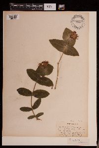 479781[1290102]Rummels, Amy s.n.1896-05-16 United States, Minnesota, Goodhue, Zumbrota [T110N;R15W;S31], 44.294132 -92.669081 |
MIN:Plants | 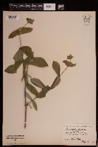 952585[1291754]Stork, H.E. United States, Minnesota, Goodhue |
MIN:Plants | 952578[1292255]Harrigan, A. s.n.1924-06-00 United States, Minnesota, Saint Louis, Greaney, 47.967145 -93.021006 |
MIN:Plants | 952577[1292256]Kramer, Leona s.n.1927-00-00 United States, Minnesota, Mower, [no further data], 43.67147 -92.752514 |
MIN:Plants | 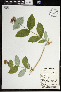 0968483[1368024]T. J. S. Whitfeld 20872019-06-14 United States, Minnesota, Lake, Boundary Waters Canoe Area Wilderness, southern end of Lake Insula in the area burned during 2011 Pagami Creek Fire, 47.901361 -91.2845, 454m |
MIN:Plants | 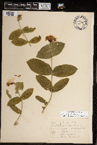 968851[1391526]Gammon, Inaz 1903-07-15 United States, Minnesota, Hennepin, 44.903296 -93.566346 |
MIN:Plants | []Timothy J. S. Whitfeld 31692022-06-03 United States, Minnesota, Washington, Crystal Spring Scientific and Natural Area, 0.4 miles northeast of the intersection of Scandia Trail North and Hwy 95, 45.26226 -92.765461, 270m |
MIN:Plants |  971269[1394746]M. H. Nee 658302020-06-24 United States, Wisconsin, Oneida, 17 km (straight line) WNW of Heafford Junction, along Village Road and Little Somo River. T 36 N; R 4 E; SW¼SE¼ sect. 24, 45.5875 -89.926944, 465m |
MIN:Plants |  973588[1397142]Lee, Michael MDL55912011-06-15 United States, Minnesota, Lake, Along the Snowbank Hiking Trail in strongly rolling bedrock terrain on the west side of Snowbank Lake, 19 miles east-northeast of Ely., 47.99222479 -91.4556772, 442m |
MIN:Plants |  973031[1398584]Lee, Michael MDL58562012-05-30 United States, Minnesota, Lake, Boundary Waters Canoe Area Wilderness; On the shores of Moose Lake in rugged bedrock terrain 17 miles east-northeast of Ely. Local on the northernmost island in Section 28., 47.9986625403 -91.4959759599, 411m |
Google Map
Google Maps is a web mapping service provided by Google that features a map that users can pan (by dragging the mouse) and zoom (by using the mouse wheel). Collection points are displayed as colored markers that when clicked on, displays the full information for that collection. When multiple species are queried (separated by semi-colons), different colored markers denote each individual species.