University of Minnesota
http://www.umn.edu/
612-625-5000
http://www.umn.edu/
612-625-5000
Minnesota Biodiversity Atlas
Bell Museum
Dataset: MIN-Plants
Taxa: Convolvulaceae
Search Criteria: excluding cultivated/captive occurrences
Bell Museum plants | |
 MIN:Plants |  Calystegia sepium (L.) R. Brown 966369[1359208]Timothy J. S. Whitfeld 27982021-06-24 United States, Minnesota, Washington, Lost Valley Prairie Scientific and Natural Area, 2 miles east north east of intersection of State Highway 95 and 110th., 44.798115 -92.822709, 284m |
MIN:Plants |  Calystegia sepium (L.) R. Brown 966749[1359384]Lee, Jeffrey G. 2662018-07-24 United States, Minnesota, Koochiching, Access by canoe at the Sturgeon River public water carry-in on the Big Fork River, at the terminus of NFR-170 from County Road 30. Specimen is located 520 m south of water access. Big Falls is the nearest town 6 km to the east-southeast., 48.21 -93.88, 347m |
MIN:Plants | Calystegia sepium (L.) R. Brown []Timothy J. S. Whitfeld 33602022-07-07 United States, Minnesota, Lac qui parle, Salt Lake, 3.25 miles south southeast of Marietta, 44.974252 -96.434262, 340m |
MIN:Plants |  Calystegia sepium (L.) R. Brown 972444[1395993]Janssens, J. 75/1941975-07-22 Belgium, Antwerp, Sint-Job-in-'t-Goor, Turnhout |
MIN:Plants |  Calystegia sepium (L.) R. Brown 972445[1395994]Janssens, J. 1931974-06-13 Belgium, Kiel |
MIN:Plants | Cuscuta pentagona Engelmann 510818[]Bright, R. s.n.1972-00-00 United States, Idaho, Franklin, [no further data] |
MIN:Plants | Cuscuta pentagona var. pentagona Engelmann 430318[]Lee, Michael D. MDL18981997-08-01 United States, Minnesota, Stearns, Along Frostview Road three miles west of Cold Spring; granite outcrop; T123N R30W NW1/4 of NW1/4 Sec. 29, 45.434841 -94.475712 |
MIN:Plants | Cuscuta pentagona var. pentagona Engelmann 225361[]Stevenson, J. 1731912-07-15 United States, Minnesota, Beltrami, Bemidji;;146N;33W;, 47.453829 -94.863614 |
MIN:Plants | Cuscuta pentagona var. pentagona Engelmann 174841[]Illegible name L51 United States, Minnesota, Blue Earth, [no further data];;;;, 44.005311 -94.079226 |
MIN:Plants | Cuscuta pentagona var. pentagona Engelmann 174954[]Moyer, Lycurgus 29581901-06-25 United States, Minnesota, Big Stone, Ortonville;;121N;46W;, 45.284263 -96.412452 |
MIN:Plants | Cuscuta pentagona var. pentagona Engelmann 174955[]Sheldon, Edmund S72281893-09-00 United States, Minnesota, Big Stone, Graceville;;124N;46W;, 45.542392 -96.431449 |
MIN:Plants | Cuscuta pentagona var. pentagona Engelmann 174958[]Sheldon, Edmund S72941892-09-00 United States, Minnesota, Traverse, Browns Valley;;125N;49W;, 45.625176 -96.801725 |
MIN:Plants | Cuscuta pentagona var. pentagona Engelmann 494458[]Huff, N. s.n.1941-09-01 United States, Minnesota, Yellow Medicine, Granite Falls;;116N;39W;, 44.80874 -95.556561 |
MIN:Plants | Cuscuta pentagona var. pentagona Engelmann 574703[]Moore, John 247731959-07-31 United States, Minnesota, Kittson, Kittson County ... along county road grade 9 miles north of Lancaster Along co. rd. grade 9 mi. N of Lancaster. , 48.988558 -96.804215 |
MIN:Plants | Cuscuta pentagona var. pentagona Engelmann 586452[]Moore, John 265451963-09-10 United States, Minnesota, Pipestone, Pipestone County ... west of the museum building, Pipestone National Monument;Pipestone National Monument;106N;46W;, 43.979723 -96.367859 |
MIN:Plants | Cuscuta pentagona var. pentagona Engelmann 622330[]Westkaemper, Remberta s.n.1970-07-00 United States, Minnesota, Stearns, Stearns County ... St. Johns U ... Collegeville;;125N;29W;, 45.630249 -94.325498 |
MIN:Plants | Cuscuta pentagona var. pentagona Engelmann 782124[]Dana, R. 850391985-07-11 United States, Minnesota, Clay, Clay County ... S1/2 NE1/4 Sec. 15, T139N, R46W. Bluestem Prairie ... former beach ridge of Glacial Lake Agassiz.;Bluestem Prairie Scientific Natural Area;139N;46W;15, 46.854948 -96.473403 |
MIN:Plants | Cuscuta pentagona var. pentagona Engelmann 174951[]MacMillan, C.; et al. MS561890-08-00 United States, Minnesota, Crow Wing, Brainerd;;133N;28W;03, 46.34845 -94.24059 |
MIN:Plants | Cuscuta pentagona var. pentagona Engelmann 174952[]Menzel, Max s.n.1892-07-00 United States, Minnesota, Pipestone, Pipestone [assuming the quarry area; town generally noted as Pipestone City by collector];Pipestone National Monument;106N;46W;01, 44.01585 -96.31767 |
MIN:Plants | Cuscuta pentagona var. pentagona Engelmann 174953[]Sheldon, Edmund S14351891-08-00 United States, Minnesota, Pipestone, Pipestone. Pipestone Co.;;106N;46W;, 43.979723 -96.367859 |
MIN:Plants | Cuscuta pentagona var. pentagona Engelmann 174956[]Sheldon, Edmund s.n.1891-08-00 United States, Minnesota, Pipestone, Pipestone. Pipestone Co.;;106N;46W;, 43.979723 -96.367859 |
MIN:Plants | Cuscuta pentagona var. pentagona Engelmann 174957[]Menzel, Max s.n.1894-07-00 United States, Minnesota, Pipestone, Pipestone [assuming the quarry area; town generally noted as Pipestone City by collector];Pipestone National Monument;106N;46W;01, 44.01585 -96.31767 |
MIN:Plants | Cuscuta pentagona var. pentagona Engelmann 174960[]Sheldon, Edmund S71981892-09-00 United States, Minnesota, Traverse, Browns Valley;;N;;, 45.625176 -96.801725 |
MIN:Plants | Cuscuta pentagona var. pentagona Engelmann 174961[]Menzel, Max s.n.1895-07-00 United States, Minnesota, Pipestone, Pipestone [assuming the quarry area; town generally noted as Pipestone City by collector];Pipestone National Monument;106N;46W;01, 44.01585 -96.31767 |
MIN:Plants | Cuscuta pentagona var. pentagona Engelmann 174962[]Wheeler, William 10811901-09-10 United States, Minnesota, Rock, On the Mound, Luverne;;N;;, 43.694691 -96.190584 |
MIN:Plants | Cuscuta pentagona var. pentagona Engelmann 174963[]MacMillan, C.; et al. 376Sk1900-08-00 United States, Minnesota, Polk, Holmes [historic railroad station at Melvin], Polk Co.;;148N;45W;22, 47.622952 -96.377032 |
MIN:Plants | Cuscuta pentagona var. pentagona Engelmann 174993[]Ballard, C. 26741900-08-00 United States, Minnesota, Kittson, St. Vincent;;163N;51W;, 48.945898 -97.210703 |
MIN:Plants | Cuscuta pentagona var. pentagona Engelmann 174994[]Ballard, C. 26741900-08-00 United States, Minnesota, Kittson, St. Vincent;;163N;51W;, 48.945898 -97.210703 |
MIN:Plants | Cuscuta pentagona var. pentagona Engelmann 337897[]Moyle, J. 23321936-08-15 United States, Minnesota, Otter Tail, On shore of Ottertail Lake;;N;;, 46.399132 -95.661637 |
MIN:Plants | Cuscuta pentagona var. pentagona Engelmann 337898[]Moyle, J. 23321936-08-15 United States, Minnesota, Otter Tail, Shore of Ottertail Lake;;N;;, 46.399132 -95.661637 |
MIN:Plants | Cuscuta pentagona var. pentagona Engelmann 338258[]Moyle, J. 23321936-08-15 United States, Minnesota, Otter Tail, Shore of Otter Tail Lake;;N;;, 46.399132 -95.661637 |
MIN:Plants | Cuscuta pentagona var. pentagona Engelmann 412851[]Moore, John; Moore, Marjorie 115311939-08-07 United States, Minnesota, Kittson, Along the Red River at St. Vincent;;N;;, 48.96624 -97.22591 |
MIN:Plants | Cuscuta pentagona var. pentagona Engelmann 413089[]Moore, John; Moore, Marjorie 113241939-07-31 United States, Minnesota, Lake of the Woods, S side of American Point;Northwest Angle;168N;33W;, 49.33962 -94.925446 |
MIN:Plants | Cuscuta pentagona var. pentagona Engelmann 619272[]Westkaemper, Remberta s.n.1970-07-00 United States, Minnesota, Stearns, Stearns Co. Collegeville;;125N;29W;, 45.630249 -94.325498 |
MIN:Plants | Cuscuta pentagona var. pentagona Engelmann 828260[]Dana, Robert 910501991-08-17 United States, Minnesota, Kittson, Skull Lake WMA; SE1/4 NE1/4 Sec.23 T163N R47W, 48.927 -96.695 |
MIN:Plants | Cuscuta pentagona var. pentagona Engelmann 430227[]Lee, Michael D. MDL19181997-08-18 United States, Minnesota, Stearns, Quarry Park Natural Area on the south side of Waite Park; on large granite outcrop. T124N R28W NE1/4 of NE1/4 Sec., 45.522862 -94.250075 |
MIN:Plants | Cuscuta pentagona var. pentagona Engelmann 225360[]Stevenson, J. 1731912-07-15 United States, Minnesota, Beltrami, Bemidji;;146N;33W;, 47.453829 -94.863614 |
MIN:Plants | Cuscuta pentagona var. pentagona Engelmann 923097[]Anderson, Derek 13342009-08-17 United States, Minnesota, Mower, Hormel Nature Center. On the northeast side of the city of Austin along Dobbins Creek. NENW of section;<No data>;103N;17W;31, 43.6855556 -92.9238889 |
MIN:Plants |  Cuscuta pentagona Engelmann 953859[1294906]Wible, Paul G. s.n.1928-07-23 United States, Indiana, Lawrence, Northeastern Lawrence County |
MIN:Plants | Cuscuta californica Hooker & Arnot 232598[]Congdon, J. s.n.1891-07-29 United States, California, Mariposa, Wawona;Yosemite National Park;;;, 37.53694 -119.65528 |
MIN:Plants |  Cuscuta indecora Choisy 490258[1299073]Stevens, O. 12251950-08-05 United States, North Dakota, Barnes, Valley City |
MIN:Plants | Ipomoea hederacea Jacquin 175226[]Holzinger, John s.n.1886-08-00 United States, Minnesota, Winona, [no further data];;;;, 44.0479 -91.6404 |
MIN:Plants | Ipomoea hederacea Jacquin 175227[]Holzinger, John s.n.1886-08-00 United States, Minnesota, Winona, [no further data];;;;, 44.0479 -91.6404 |
MIN:Plants |  Ipomoea hederacea Jacquin 953789[1294696]Jenkins, F. E. s.n.1894-08-00 United States, Illinois, Montgomery, Butler |
MIN:Plants |  Ipomoea hederacea Jacquin 953791[1294697]Wible, Paul G. s.n.1928-07-27 United States, Indiana, Lawrence, Northeastern Lawrence County |
MIN:Plants | 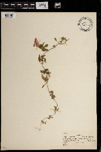 Ipomoea hederacea Jacquin 0967753[1368302] s.n.1938-05-08 United States, Texas |
MIN:Plants | 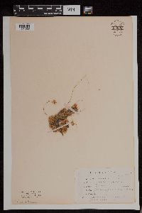 Cuscuta cuspidata Engelm. 953862[1294903]Jenkins, F. E. s.n.1894-08-00 United States, Illinois, Montgomery, Raymond |
MIN:Plants | Calystegia macounii (Greene) Brummitt 477093[]Hammer, W. s.n.2002-07-02 United States, Minnesota, Ramsey, Arden Hills. Twin Cities Army Ammunition Plant-Arden Hills Army Training Site. Grassland management unit 12. SW1/4 NE1/4 SE1/4 of section;;030N;23W;15, 45.086451 -93.15755 |
MIN:Plants | Calystegia macounii (Greene) Brummitt 174683[]Butters, F.; et al. 41621921-06-18 United States, Minnesota, Traverse, Lake Traverse;;;;, 45.691689 -96.752701 |
MIN:Plants | Calystegia macounii (Greene) Brummitt 174684[]Ballard, C. 28651901-06-11 United States, Minnesota, Clay, Sabin [later pencilled note indicates 'about 10 mi SE of Moorhead'] Sabin. 138N 47W , 46.761139 -96.610232 |
MIN:Plants | Calystegia macounii (Greene) Brummitt 265908[]Skinner, S. 671902-06-11 United States, Minnesota, Jackson, Heron Lake region;;;;, 43.772775 -95.345306 |
MIN:Plants | Calystegia macounii (Greene) Brummitt 370231[]Moore, John; Thatcher, E. 141801941-06-10 United States, Minnesota, Wilkin, Champion Township. SE1/4 of section;;130N;45W;32, 46.02875 -96.359298 |
MIN:Plants | Calystegia macounii (Greene) Brummitt 371145[]Moore, John 131161940-06-20 United States, Minnesota, Yellow Medicine, 2 mi. W of Granite Falls;;;;, 44.80995 -95.586401 |
MIN:Plants | Calystegia macounii (Greene) Brummitt 371191[]Moore, John 131371940-06-21 United States, Minnesota, Lincoln, Along the rrailroad right-of-way, W of Hendricks;;;;, 44.507186 -96.424213 |
MIN:Plants | Calystegia macounii (Greene) Brummitt 437211[]Moore, John; Hall, Robert 166251944-06-14 United States, Minnesota, Renville, Railroad right-of-way, 3 mi. E of Franklin.;;113N;33W;, 44.585918 -94.812735 |
MIN:Plants | Calystegia macounii (Greene) Brummitt 444889[]Moore, John; Tryon, R. 176071945-07-09 United States, Minnesota, Nobles, Along the r.r. right-of-way at Reading;;;;, 43.703575 -95.713068 |
MIN:Plants | Calystegia macounii (Greene) Brummitt 550568[]Cotter Tucker, Shirley 41651957-06-27 United States, Minnesota, Polk, Along the Great Northern railroad, E of the Northwest School of Agriculture, Crookston.;;;;, 47.774138 -96.608121 |
MIN:Plants | Calystegia macounii (Greene) Brummitt 568537[]Moore, John 250501960-06-18 United States, Minnesota, Kittson, At Hallock;;;;, 48.774426 -96.946447 |
MIN:Plants | Calystegia macounii (Greene) Brummitt 574661[]Moore, John 246381959-06-17 United States, Minnesota, Pipestone, 3 mi east of Pipestone;;106N;45W;, 43.979365 -96.246045 |
MIN:Plants | Calystegia macounii (Greene) Brummitt 585424[]Moore, John; Jensen, J. 263551963-06-19 United States, Minnesota, Pipestone, Along the railroad. 6 mi. west of Pipestone;;106N;47W;, 43.980149 -96.440828 |
MIN:Plants | Calystegia macounii (Greene) Brummitt 585581[]Moore, John 263391963-06-18 United States, Minnesota, Pipestone, East pasture.;Pipestone National Monument;106N;46W;01, 44.015848 -96.317669 |
MIN:Plants | Calystegia macounii (Greene) Brummitt 712001[]Smith, Welby 9471979-06-24 United States, Minnesota, Wright, 0.2 mi. N of Hwy. 75, 5.5 mi. NW of its jct. with Hwy. 25 in Monticello. SE1/4 NW1/4 of section;;122N;25W;30, 45.345989 -93.884027 |
MIN:Plants | Calystegia macounii (Greene) Brummitt 715220[]Severson, M. 431979-07-03 United States, Minnesota, Polk, 4.5 mi. S of Fischer. W1/2 of NW1/4 of section;Malmberg Prairie Scientific Natural Area;149N;48W;16, 47.72417 -96.813965 |
MIN:Plants | Calystegia macounii (Greene) Brummitt 727185[]Herman, J. 831979-07-10 United States, Minnesota, Norman, 5 mi W of Syre. ;Twin Valley Prairie Scientific Natural Area;143N;45W;23, 47.187516 -96.353808 |
MIN:Plants | Calystegia macounii (Greene) Brummitt 730598[]Petron, T. 671980-06-09 United States, Minnesota, Wilkin, 6.5 mi NW of Rothsay. NE1/4 NW1/4 of section;Western Prairie South Scientific Natural Area;135N;46W;12, 46.521816 -96.414416 |
MIN:Plants | Calystegia macounii (Greene) Brummitt 730807[]Benson, Douglas 1251981-06-22 United States, Minnesota, Wilkin, S-central SE1/4 SW1/4 of section;Pembina Trail Preserve Scientific Natural Area;133N;45W;24, 46.318653 -96.290714 |
MIN:Plants | Calystegia macounii (Greene) Brummitt 732707[]Severson, M. 4131980-06-26 United States, Minnesota, Becker, 10 mi W of Ogema. NE1/4 SW1/4 of section;Zimmerman Prairie [TNC];142N;43W;16, 47.115026 -96.14142 |
MIN:Plants | Calystegia macounii (Greene) Brummitt 735741[]Benson, Douglas 3301981-07-23 United States, Minnesota, Wilkin, W edge of preserve; near NW corner. SW1/4 NW1/4 of section;Kettledrummer Prairie, The Nature Conservancy;133N;45W;12, 46.347907 -96.290982 |
MIN:Plants | Calystegia macounii (Greene) Brummitt 739789[]Converse, C. 15041982-07-07 United States, Minnesota, Pope, NE1/4 SW1/4 of section;Ordway Prairie, The Nature Conservancy;123N;36W;19, 45.448674 -95.245019 |
MIN:Plants | Calystegia macounii (Greene) Brummitt 741480[]Converse, C. 12361982-06-21 United States, Minnesota, Chippewa, NW1/4 NW1/4 of section;Chippewa Prairie, The Nature Conservancy;119N;43W;01, 45.144714 -95.990404 |
MIN:Plants | Calystegia macounii (Greene) Brummitt 741520[]Converse, C. 16681982-07-20 United States, Minnesota, Otter Tail, E1/2 of section;Ottertail Prairie Scientific Natural Area;131N;44W;17, 46.159244 -96.235363 |
MIN:Plants | Calystegia macounii (Greene) Brummitt 753596[]Duxbury, Alexis 21401983-08-12 United States, Minnesota, Redwood, S1/2 NW1/4 of section;Wahpeton Prairie, The Nature Conservancy;110N;38W;29, 44.304782 -95.440813 |
MIN:Plants | Calystegia macounii (Greene) Brummitt 753606[]Duxbury, Alexis 14251983-07-02 United States, Minnesota, Lincoln, [no further data];Hole-in-the-Mountain Prairie, The Nature Conservancy;109N;45W;, 44.241082 -96.261721 |
MIN:Plants | Calystegia macounii (Greene) Brummitt 781284[]Smith, Welby 95071984-06-28 United States, Minnesota, Lyon, About 4 mi NNW of Russell. SE1/4 SW1/4 of section;Prairie Marshes Wildlife Management Area;111N;43W;36, 44.378119 -95.968102 |
MIN:Plants | Calystegia macounii (Greene) Brummitt 781496[]Smith, Welby 94631984-06-28 United States, Minnesota, Yellow Medicine, About 8 mi WSW of Canby. NW1/4 SW1/4 of section;Sioux Nationalion Wildlife Management Area;114N;46W;17, 44.681835 -96.429592 |
MIN:Plants | Calystegia macounii (Greene) Brummitt 753669[]Duxbury, Alexis 15521983-07-13 United States, Minnesota, Lincoln, [no further data];Hole-in-the-Mountain Prairie, The Nature Conservancy;109N;45W;, 44.241082 -96.261721 |
MIN:Plants | Calystegia macounii (Greene) Brummitt 492728[]Wheeler, Gerald 163751997-06-28 United States, Minnesota, Swift, Ca. 10 mi. NNE of Kerkhoven. Monson Lake. W1/2 NE1/4 NW1/4 of section;Monson Lake State Park;121N;37W;01, 45.318174 -95.265442 |
MIN:Plants | Cuscuta obtusiflora var. glandulosa Engelmann 264311[]Holzinger, John M. s.n.1897-07-00 United States, Minnesota, Winona, [no further data], 44.0479 -91.6404 |
MIN:Plants | 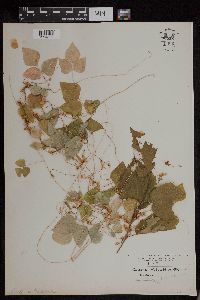 Cuscuta obtusiflora var. glandulosa Engelmann 955981[1294833]Kaliher, Earl L. s.n.1927-08-24 United States, Minnesota, Todd, Ward Springs, 45.791389 -94.808333 |
MIN:Plants | Calystegia sepium subsp. angulata Brummitt 174686[]Campbell, Jennie E. s.n.1895-07-00 United States, Minnesota, Stearns, Waite Park [T124N;R28W], 45.541667 -94.205126 |
MIN:Plants | Calystegia sepium subsp. angulata Brummitt 560909[]Ownbey, Gerald B. 28201959-07-12 United States, Minnesota, Clearwater, NE1/4 Sec. 4, T149N, R36W. 2.5 mi. due W of Clearwater Lake. Co. Rd. 14., 47.753352 -95.269634 |
MIN:Plants | Calystegia sepium subsp. angulata Brummitt 670611[]Heitlinger, Mark E. 2941971-07-13 United States, Minnesota, McLeod, Schaefer Prairie, E of Buffalo Creek; SE1/4 Sec. 34 T115N R29W, 44.72505 -94.30491 |
MIN:Plants | Calystegia sepium subsp. angulata Brummitt 817651[]Engels, Audrey s.n.1991-06-30 United States, Minnesota, Aitkin, T49N, R25W, Sec. 33, NW1/4. Engels Farm, ca. 2 1/2 mi. SW of Palisade, Mississippi River., 46.688685 -93.516311 |
MIN:Plants | Calystegia spithamaea subsp. stans (Michs.) Brunnitt 480800[]Gerdes, Lynden B. 25691998-06-01 United States, Minnesota, Cook, Superior National Forest, northwest of the Gunflint Trail (Cty. 12)/FR 1347 junction. Superior National Forest; T65N R04W S26NWSE, 48.084497 -90.803753 |
MIN:Plants | Calystegia spithamaea subsp. stans (Michs.) Brunnitt 914186[]Lee, Michael D. MDL43732007-06-13 United States, Minnesota, Wadena, 5.5 miles southeast of Menahga. Right of way of County Highway 23 just north of 324th Street. T137N R34W SW1/4 of SW1/4 of NW1/4 Sec.8. UTM: 5173352N 345832E, 46.695953 -95.016458 |
MIN:Plants | Calystegia spithamaea subsp. stans (Michs.) Brunnitt 178764[]Rosendahl, C. 4761902-06-13 United States, Minnesota, Houston, Spring Grove;;101N;07W;11, 43.56565 -91.64095 |
MIN:Plants | Calystegia spithamaea subsp. stans (Michs.) Brunnitt 291832[]Fryklund, P. O. s.n.1925-07-05 United States, Minnesota, Roseau, [no further data], 48.791028 -95.795207 |
MIN:Plants | Calystegia spithamaea subsp. stans (Michs.) Brunnitt 462962[]Lakela, Olga 142091952-07-18 United States, Minnesota, Saint Louis, Namakan Narrows [Voyageurs National Park; T69N;R17W], 48.428244 -92.527018 |
MIN:Plants | Calystegia spithamaea subsp. stans (Michs.) Brunnitt 532306[]Lakela, Olga 199601956-06-22 United States, Minnesota, Saint Louis, Hwy. 7, S of Payne, 47.086699 -92.599358 |
MIN:Plants | Calystegia spithamaea subsp. stans (Michs.) Brunnitt 532883[]Lakela, Olga 200201956-06-24 United States, Minnesota, Saint Louis, S of Hwy. 23, Pelican Lake, Orr [Kabetogama State Forest], 48.06099 -92.89713 |
MIN:Plants | Calystegia spithamaea subsp. stans (Michs.) Brunnitt 583404[]Kellner, Harriet M. 2501956-07-05 United States, Minnesota, Lake, Encampment Forest [T53N;R10W], 47.081385 -91.622118 |
MIN:Plants | Calystegia spithamaea subsp. stans (Michs.) Brunnitt 831349[]Engels, Audrey s.n.1992-06-25 United States, Minnesota, Aitkin, Approx. 2 airmiles due NW of McGregor. T48N R24W, NE1/4 NW1/4 Sec.23, 46.630494 -93.348886 |
MIN:Plants | Calystegia spithamaea subsp. stans (Michs.) Brunnitt 435188[]Boe, Janet 970625061997-06-25 United States, Minnesota, Aitkin, McGregor Airport. T48N; R23W NW1/4 of NW1/4 of sec 30, 46.61596 -93.306121 |
MIN:Plants | Calystegia spithamaea subsp. stans (Michs.) Brunnitt 454396[]Lee, Michael D. MDL27292000-06-21 United States, Minnesota, Lake, Superior National Forest two miles north-northeast of Cramer. Above Paccini Lake ... T59N R6 W NW1/4 of NE1/4 Sec. 34, 47.551556 -91.07583 |
MIN:Plants | 724591[]Smith, Welby R. 33611981-08-17 United States, Minnesota, Wright, T119N, R25W, NW1/4 NE1/4 Sec. 15. Between Hwy. 55 and Soo Line Railroad tracks, about 1/4 mi. NW of the springs Wright Co.; T119N, R25W, NW1/4 NE1/4 Sec. 15. Between Hwy. 55 and Soo Line R.R. tracks, about 1/4 mi. NW of the springs wayside., 45.115773 -93.817185 |
MIN:Plants | Cuscuta umbrosa Beyrich ex Hooker 430042[]Myhre, Karen M. 32521992-09-01 United States, Minnesota, Cass, Located on the west shore of Headquarters Bay in Leech Lake, T142N R30W NE1/4 of NW1/4 of sec 22 [Chippewa National Forest / Leech Lake Indian Reservation], 47.102298 -94.459786 |
MIN:Plants | Cuscuta umbrosa Beyrich ex Hooker 459423[]Dana, Robert 921371992-08-27 United States, Minnesota, Kittson, North Branch Two Rivers at Lancaster. SE1/4 of SW1/4 of section 7, 48.869345 -96.787789 |
MIN:Plants | Cuscuta umbrosa Beyrich ex Hooker 697911[]Ownbey, Gerald 55201976-09-10 United States, Minnesota, Dakota, T 115 N R 17 W SE 1/4 Sect. 27. At bridge across Vermillion River, Rte. No. 54 (91), Hastings. N of river, W of bridge., 44.738359 -92.842783 |
MIN:Plants | Cuscuta umbrosa Beyrich ex Hooker 728507[]Lustig, K. 10371979-08-27 United States, Minnesota, Sherburne, Mississippi Scenic and Recreational River Islands SNA: Mississippi River islands between Monticello and Elk River, sec. 2, 3, 4, T32N R26, 27W; sec. 7, 9, 18, T121N R23, 24W, 45.296327 -93.667474 |
MIN:Plants | Cuscuta umbrosa Beyrich ex Hooker 824512[]Cholewa, A. F. 20221991-07-18 United States, Minnesota, Ramsey, Fort Snelling State Park. S side of Pike Island. T28N;23W;21, 44.891458 -93.167129 |
Google Map
Google Maps is a web mapping service provided by Google that features a map that users can pan (by dragging the mouse) and zoom (by using the mouse wheel). Collection points are displayed as colored markers that when clicked on, displays the full information for that collection. When multiple species are queried (separated by semi-colons), different colored markers denote each individual species.